
What You Missed
Summer 2018
Summer 2018
![]()
![]()
![]()
![]()
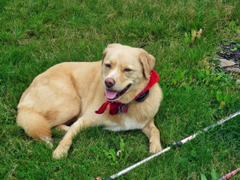
![]() On Saturday, September 22nd, I had scheduled a hike up Table with my brother-in-law Jeff, Son Karl and grandsons Bryce and Lucas. Bryce and I have been working on his 3500's and I though Table was close and might have fewer people hiking compared to the Devil's Path or the Blacks. The weather report was for cloudy skies with some sun in the afternoon. I began to get dressed at 8:00 AM and Sheila knew we were going on a hike. She didn't leave my side and was underfoot for most of the time. The temperature was in the high 50's with a stiff breeze. I got dressed in a long-sleeved Mammut crew top which is a little heaver than what I have been wearing. I put on a short-sleeved baselayer and a light windbreaker. I wore a pair of RailRiders hiking pants which are expensive but last along time and have features like deep pockets and a generous cut which I really like. The pants have Velcro closures at the ankles which I hoped would mean I did not need gaiters. I decided to wear my keen Glarus hiking boots which fit well and, of course, have been discontinued. Jeff arrived at 8:40 AM and we loaded our gear into my car and left Livingston Manor. We headed out the DeBruce Road at 8:45 AM. At the end I turned right onto Route 47 and drove to the intersection with the road to the Denning trailhead. I turned left and drove through Claryville and on toward the end of the road. We arrived at the trailhead parking area at 9:15 AM. Karl was already there with the two boys and I was surprised to see that the parking area was almost full! It seemed most people had already left but the man in the car next to us was still getting ready. He informed me he was going to bushwhack in the area to hunt bear! We got our gear ready and I set my electronics as we set out on the trail at 9:25 AM. The first 1.3 miles of the trail is almost flat rolling a little along a woods road. The trail was very wet with both standing and running water. We all talked to each other and the walk to the turn toward Table went quickly. At the turn I pointed out the sign that designates the eastern terminus of the Finger Lakes Trail. We walked down through the rocks toward the river and I took a few pictures of the boys and Sheila perched on a big rock. We had to cross a deep little stream just before the first bridge but we all made it safely. The first bridge was in good shape even after several storms and someone had replaced a few of the boards. I took some pictures from one end and then some from the middle of the bridge. I also took a few after I crossed. I knew the second bridge would be tricky as it was constructed of two logs with just a cable to hold onto. When we arrived at the bridge, I was surprised to see that the two logs now had planks that formed decking and a nice wooden handrail. These additions looked new. I stopped to take pictures of the bridge before catching up to the others. As we continued, we passed by a cairn that marked the turn off to the Fisherman's Path and I mentioned the significance to the group. We continued along the trail passing some legal campsites before getting to the start of what would be a climb of over 1700 feet during the next 2.1 miles. At this point the "bear hunter" came toward us and I asked him how he was doing. He said he was looking for the Fisherman's Path along the river. I told him how to find it and we continued on.
On Saturday, September 22nd, I had scheduled a hike up Table with my brother-in-law Jeff, Son Karl and grandsons Bryce and Lucas. Bryce and I have been working on his 3500's and I though Table was close and might have fewer people hiking compared to the Devil's Path or the Blacks. The weather report was for cloudy skies with some sun in the afternoon. I began to get dressed at 8:00 AM and Sheila knew we were going on a hike. She didn't leave my side and was underfoot for most of the time. The temperature was in the high 50's with a stiff breeze. I got dressed in a long-sleeved Mammut crew top which is a little heaver than what I have been wearing. I put on a short-sleeved baselayer and a light windbreaker. I wore a pair of RailRiders hiking pants which are expensive but last along time and have features like deep pockets and a generous cut which I really like. The pants have Velcro closures at the ankles which I hoped would mean I did not need gaiters. I decided to wear my keen Glarus hiking boots which fit well and, of course, have been discontinued. Jeff arrived at 8:40 AM and we loaded our gear into my car and left Livingston Manor. We headed out the DeBruce Road at 8:45 AM. At the end I turned right onto Route 47 and drove to the intersection with the road to the Denning trailhead. I turned left and drove through Claryville and on toward the end of the road. We arrived at the trailhead parking area at 9:15 AM. Karl was already there with the two boys and I was surprised to see that the parking area was almost full! It seemed most people had already left but the man in the car next to us was still getting ready. He informed me he was going to bushwhack in the area to hunt bear! We got our gear ready and I set my electronics as we set out on the trail at 9:25 AM. The first 1.3 miles of the trail is almost flat rolling a little along a woods road. The trail was very wet with both standing and running water. We all talked to each other and the walk to the turn toward Table went quickly. At the turn I pointed out the sign that designates the eastern terminus of the Finger Lakes Trail. We walked down through the rocks toward the river and I took a few pictures of the boys and Sheila perched on a big rock. We had to cross a deep little stream just before the first bridge but we all made it safely. The first bridge was in good shape even after several storms and someone had replaced a few of the boards. I took some pictures from one end and then some from the middle of the bridge. I also took a few after I crossed. I knew the second bridge would be tricky as it was constructed of two logs with just a cable to hold onto. When we arrived at the bridge, I was surprised to see that the two logs now had planks that formed decking and a nice wooden handrail. These additions looked new. I stopped to take pictures of the bridge before catching up to the others. As we continued, we passed by a cairn that marked the turn off to the Fisherman's Path and I mentioned the significance to the group. We continued along the trail passing some legal campsites before getting to the start of what would be a climb of over 1700 feet during the next 2.1 miles. At this point the "bear hunter" came toward us and I asked him how he was doing. He said he was looking for the Fisherman's Path along the river. I told him how to find it and we continued on.
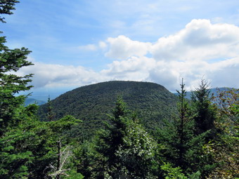
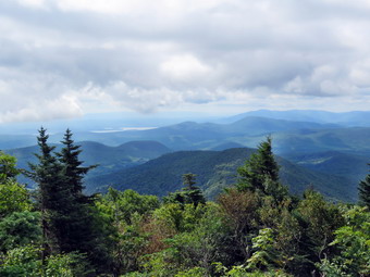
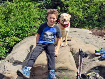
 We met three women coming down the trail with three dogs. We all put our dogs on their leashes as we passed each other. The women (and the dogs) had stayed at the lean-to overnight and were on their way out. We walked and talked and both boys seemed to be doing well. Bryce is seven and has been out with me before. Lucas is only five but he was doing well. There are two "bumps" before the final climb to the summit and several sets of rocks to work through. Some of the climbs are a little steep but they are followed by gentler grades. I was feeling a little tired as we worked our way up the mountain but Bryce was doing fine. Jeff told me he was beginning to feel like he might want to turns around before the summit and Lucas was beginning to lag. I suggested we get to the lookout on the way up the mountain and make a decision there. After the second bump at 2.75 miles and just before the final ascent, we walked along a path to the right that led to a lookout to the south. The sun was out and the view was beautiful! We could see the summit of Table to our left and then Peekamoose almost straight ahead. There were mountains in the background and Van Wyck Mountain was very prominent to the right. It has an unmistakable profile. I took some pictures of everything and a couple of the boys and the dog. We decided that Bryce and I would go on to the summit and I would then bring him home. Everybody else would return to the car and Karl would bring Jeff back to his truck in Livingston Manor. Bryce, Sheila and I left the lookout and returned to the main trail. We turned right and got ready for the final ascent to the summit. We passed over one more "bump" and then started the last climb which is .7 miles but gains over 600 feet. This final ascent up the mountain is not one of my favorites. In several places the trail hugs the side of the hill and is pretty rocky. We passed the spring and the lean-to and then started up the steepest part to the flat summit. We met two young men coming down the trail. They had started at the Peekamoose trailhead so that they could traverse both peaks. They said "Hello" as I pulled Sheila to the side of the trail so that they could pass. They were moving very quickly! I knew this would be an interesting descent as it was steep and wet. Once on the top we came to a path on the right that led to another viewpoint. We turned onto the path and walked out to the rock that makes up the lookout. The views were still good and at a little different angle than the previous spot whet we had stopped. I took more pictures and then packed up and walked back to the main trail. We turned right and continued to ascend toward the summit. I was surprised when the summit came up so quickly and that it was marked by a cairn. We walked a little passed that point to make sure the trail started to descend. We walked back to the summit to get a drink and a snack. I debated whether or not to remove the cairn and in the end I did what I always do. I don't build cairns but I don't knock them down either. It was 12:30 PM and it had taken us over 3 hours to cover the 3.8 miles.
 We turned around and started our descent knowing there were still a few short climbs along the way. We met a man coming up the trail with what looked like a poodle! For a small dog it was doing quite well. The steep descent was slow as I suspected it would be but we made up some time and were soon neat the lean-to. The two young men we had met on our ascent were coming out of the spur trail to the lean-to. We never saw them again! We passed the spring and continued to descend through the rocks. I had to admit that going down WAS easier than going up but not as easy as I would have liked. The two "bumps" on the way back were not appreciated by either of us but both look a lot more imposing than they really are. We met a few people coming up the mountain and I thought it was rta5ther late to go for the summit. Soon we were down to the last descent toward the river which is very rocky and took its toll. We crossed both bridges without incident and then had to work our way up the hill back to the trail to the parking area. We turned left at the top of the hill and headed back to the car. Along the way we met several groups of people including some young men looking for the nearest campsite and dragging large cooler. By this time we both had a sense of urgency to get back to the car and get home. The walk back was more pleasant with hiking buddy Bryce. The hike back on the woods road seemed to go faster than previous trips and we were both glad to see the gate and the parking lot. We arrived back at the car at 3:15 PM having covered 7.6 miles and 2325 vertical feet in 5 hours and 50 minutes with almost an hour of stopped time. I look forward to climbing Peekamoose with Bryce!
![]()
![]()
![]()
![]()
![]() On Wednesday, September 19th I decided to hike despite a morning appointment and cloudy skies. When I arrived home from my appointment, I checked the weather report and found there was no rain in the forecast. I decided to go to the Frick Pond area and hike the Flynn Trail to the Hodge Pond Lookout and Flynn's Point, the highest point in Sullivan County. I could then take the Flynn Trail back or head down the Big Rock Trail to Frick Pond. As I started to get ready at 10:15 AM, the temperature was in the mid 70's. I got dressed in a long-sleeved crew top with a short-sleeved baselayer. I put on a pair of RailRiders hiking pants which are expensive but last along time and have features like deep pockets and a generous cut which I really like. The pants have Velcro closures at the ankles which I hoped would mean I did not need gaiters. The ticks have been very numerous so far this season especially farther south. I decided to wear my Vasque Taku hiking boots which fit well and, of course, have been discontinued. Sheila seemed extra energetic as if she didn't want to get left behind. I loaded Sheila and my gear into the car and headed out the DeBruce Road. At 6 miles I turned left on the Mongaup Pond Road. Where the road splits I stayed left on the Beech Mountain Road and parked in the smaller at Frick Pond. There were no other cars in either of the lots as I got my gear ready and crossed the road to start our hike at 10:40 AM. The erosion at the beginning of the trail made it obvious that there had been a lot of water running down the trail. We set a quick pace up the Flynn Trail. I noticed very few new branches on the trail but I did stop to remove a few. The mosquitoes that I had hoped would be absent were fewer in number but still biting. At 11:20 AM we arrived at the junction with the Big Rock Trail. We continued straight ahead on the Flynn Trail passing the gate that separates state land from the OSI property. At 2 miles we turned right on a woods road toward the ruins of the Beech Mountain Boy Scout Camp. At 2.25 miles we passed the woods road leading down to Hodge Pond and stayed right at the split to start the hike up the hill to the lookout. The woods road is dirt and was wet and muddy in places from the recent rain.
On Wednesday, September 19th I decided to hike despite a morning appointment and cloudy skies. When I arrived home from my appointment, I checked the weather report and found there was no rain in the forecast. I decided to go to the Frick Pond area and hike the Flynn Trail to the Hodge Pond Lookout and Flynn's Point, the highest point in Sullivan County. I could then take the Flynn Trail back or head down the Big Rock Trail to Frick Pond. As I started to get ready at 10:15 AM, the temperature was in the mid 70's. I got dressed in a long-sleeved crew top with a short-sleeved baselayer. I put on a pair of RailRiders hiking pants which are expensive but last along time and have features like deep pockets and a generous cut which I really like. The pants have Velcro closures at the ankles which I hoped would mean I did not need gaiters. The ticks have been very numerous so far this season especially farther south. I decided to wear my Vasque Taku hiking boots which fit well and, of course, have been discontinued. Sheila seemed extra energetic as if she didn't want to get left behind. I loaded Sheila and my gear into the car and headed out the DeBruce Road. At 6 miles I turned left on the Mongaup Pond Road. Where the road splits I stayed left on the Beech Mountain Road and parked in the smaller at Frick Pond. There were no other cars in either of the lots as I got my gear ready and crossed the road to start our hike at 10:40 AM. The erosion at the beginning of the trail made it obvious that there had been a lot of water running down the trail. We set a quick pace up the Flynn Trail. I noticed very few new branches on the trail but I did stop to remove a few. The mosquitoes that I had hoped would be absent were fewer in number but still biting. At 11:20 AM we arrived at the junction with the Big Rock Trail. We continued straight ahead on the Flynn Trail passing the gate that separates state land from the OSI property. At 2 miles we turned right on a woods road toward the ruins of the Beech Mountain Boy Scout Camp. At 2.25 miles we passed the woods road leading down to Hodge Pond and stayed right at the split to start the hike up the hill to the lookout. The woods road is dirt and was wet and muddy in places from the recent rain.
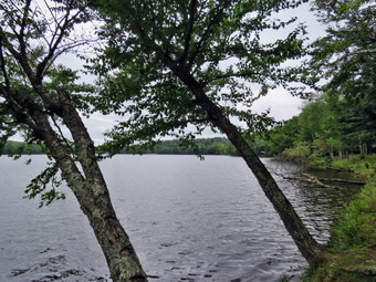
 The trail rises .4 miles gaining 270 feet for a 13% grade. As we hiked, Sheila alerted and I looked up to see a pickup truck and a surveyor's transit. I put Sheila on her leash and continued on the road. We met the surveyor and I stopped to talk. He said he was simply surveying the road for the surveyor who works for Larry Rockefeller. He indicated to me that he thought the road was on private property. I told him that I was continuing to the lookout but would research the ownership issue when I returned home. We continued up the trail passing the surveyor's assistant. At 2.65 miles the trail turns sharply right and there is a limited lookout to the north and west. We stopped and I took a few pictures before packing up and continuing on the road. We immediately turned right on another woods road which was much more well-defined than the last time I had hiked there. The trail over the next .3 miles was almost flat and very wet. At 2.9 miles we arrived at the rock that is the lookout over Hodge Pond. The trees have grown up and the view from the lookout is very limited. I took a few shots, made sure I got a drink and bar and then packed up for the return trip. I had decided that I would not hike up to the high point since it was very wet and the time was getting late. We walked back out the trail to the woods road and turned left to head back down the hill. The sun had come out so I stopped to take a few shots from the viewpoint and the continued. The surveyor's equipment was still in place but I did not see them men. Once we were off the hill we continued straight ahead and then turned right on the woods road down to Hodge Pond. We followed the road down to the field at the south end of Hodge Pond. We walked over to the edge of the pond where I dropped my pack and got out the camera. I took pictures of the pond and the blue skies with puffy white clouds. I also took a few pictures of Sheila next to my pack. Strangely, Sheila did not take a swim! I packed up and we walked up the Flynn Trail. This walk often seems long but in this day we set a rapid pace and this section went quickly. At the top of the hill we stayed to the right on the Flynn Trail heading toward the junction with the Big Rock Trail. At the junction I decided to simply continue straight ahead on the Flynn Trail rather than walk down the Big Rock trail to Frick Pond. The final 1.7 miles down the Flynn Trail often seem long and boring especially on an out and back hike. On this day the return trip seemed to fly by. At the gate we stayed left on the Flynn Trail to avoid the private property around the cabin. We arrived back at the car at 1:20 PM after hiking 6.4 miles in 2 hours and 35 minutes with a total elevation gain of 1180 feet.
![]()
![]()
![]()
![]()
![]() On Saturday, September 15th I was scheduled to go to a cross, country meet at Bear Mountain. The night before I had two bouts of leg cramps so I decided to stay home from the meet. By the afternoon I was feeling better and knew I had to get out for a hike. I asked Cindy and we both decided a short hike would be good. The temperature was in the mid 80's and the humidity very uncomfortable as we started getting ready at 2:15 PM. We decided that Trout Pond might be a little too long and settled on Huggins lake which is about a 4 hour round trip. I got dressed in a short-sleeved crew top with a short-sleeved baselayer. It was only 83 degrees and I knew I would be warm from hiking. I put on a pair of RailRiders hiking pants which are expensive but last along time and have features like deep pockets and a generous cut which I really like. The pants have Velcro closures at the ankles which I hoped would mean I did not need gaiters. The ticks have been very numerous so far this season especially farther south. I decided to wear my Keen Glarus hiking boots which fit well and, of course, have been discontinued. Sheila seemed extra energetic as if she didn't ant to get left behind in the confusion. We loaded Sheila and our gear into the car and headed out. I have come to the realization that Sheila would like to be out everyday! I drove up the Beaverkill Road and down the Campsite Road to cross the covered bridge. At the end of the road I turned right and followed Berry Brook Road to the trailhead. We arrived at the road to the parking area to find it very rough with some erosion and a few branches in the way. I chose to chance it and easily made it to the small lot parking at 2:45 PM. I got my equipment ready and set my GPS. There were no other cars in the lot when we headed out on the wide woods road to the lake. The temperature was in the mid 80's but the humidify was high making it a little uncomfortable to hike. There was some sun and the skies were mostly blue as we started the climb up the hill. The hike isn't long and the trail is well-maintained although there were a few blowdowns along the way. The first 1.2 miles is all uphill and gains almost 700 feet. Sheila was running up and down the trail and following game paths into the woods. After the initial climb, the trail descends, levels some and then climbs again until the final descent to Huggins Lake. The trail makes a sharp turn from southeast to north at about 1.6 miles. We enjoyed the downhill trek to the shores of the pond but I knew we would soon have to turn around and climb back up the hill.
On Saturday, September 15th I was scheduled to go to a cross, country meet at Bear Mountain. The night before I had two bouts of leg cramps so I decided to stay home from the meet. By the afternoon I was feeling better and knew I had to get out for a hike. I asked Cindy and we both decided a short hike would be good. The temperature was in the mid 80's and the humidity very uncomfortable as we started getting ready at 2:15 PM. We decided that Trout Pond might be a little too long and settled on Huggins lake which is about a 4 hour round trip. I got dressed in a short-sleeved crew top with a short-sleeved baselayer. It was only 83 degrees and I knew I would be warm from hiking. I put on a pair of RailRiders hiking pants which are expensive but last along time and have features like deep pockets and a generous cut which I really like. The pants have Velcro closures at the ankles which I hoped would mean I did not need gaiters. The ticks have been very numerous so far this season especially farther south. I decided to wear my Keen Glarus hiking boots which fit well and, of course, have been discontinued. Sheila seemed extra energetic as if she didn't ant to get left behind in the confusion. We loaded Sheila and our gear into the car and headed out. I have come to the realization that Sheila would like to be out everyday! I drove up the Beaverkill Road and down the Campsite Road to cross the covered bridge. At the end of the road I turned right and followed Berry Brook Road to the trailhead. We arrived at the road to the parking area to find it very rough with some erosion and a few branches in the way. I chose to chance it and easily made it to the small lot parking at 2:45 PM. I got my equipment ready and set my GPS. There were no other cars in the lot when we headed out on the wide woods road to the lake. The temperature was in the mid 80's but the humidify was high making it a little uncomfortable to hike. There was some sun and the skies were mostly blue as we started the climb up the hill. The hike isn't long and the trail is well-maintained although there were a few blowdowns along the way. The first 1.2 miles is all uphill and gains almost 700 feet. Sheila was running up and down the trail and following game paths into the woods. After the initial climb, the trail descends, levels some and then climbs again until the final descent to Huggins Lake. The trail makes a sharp turn from southeast to north at about 1.6 miles. We enjoyed the downhill trek to the shores of the pond but I knew we would soon have to turn around and climb back up the hill.
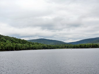
 When we arrived at the lake, I noticed that the water level was very high. There was a wet area and patches of mud on the trail just before it goes out along the shore. We avoided the mud and walked out along the dam. The leaves had not really changed colors but a few leaves were beginning to show some color. It was still sunny and the skies were blue with puffy white clouds. The clouds and trees were reflected in the pond which was very placid. I dropped my pack and got out the camera to take some pictures of the blue sky with some white clouds in one direction. I also got some shots of the colorful leaves and the reeds around the dam. At the outlet I could immediately see that the beavers had dammed the water flow and that reeds had grown to all but block the outlet flow. I took a few more pictures of the lake before returning to my pack and stowing the camera. Sheila decided to dive into the pond water several times until a stern warning stopped her. I made sure to drink a half bottle of water and get a bar before heading back to the car. The only negative point about Huggins Lake is that there is only one trail and so there are no variations available. The ascent went smoothly for the most part as we climbed the hill back to the highest point on the trail. From there we started down the other side of the hill. I was surprised that I had labored a little climbing the hill at the beginning of the hike but felt very fresh on the way back. Sheila seemed very interested in something that was on the ridge to the left of the trail and I had to keep calling her back. We arrived back at the car at 4:40 PM after hiking 3.9 miles in 1 hour and 55 minutes with a total elevation gain of 935 feet.
![]()
![]()
![]()
![]() On Wednesday, September 12th I had not been out hiking for FIVE days due to cross country and other commitments and the threat of rain showers. The forecast for Wednesday included showers in the afternoon so I decided to go out in the late morning after the fog had burned off and before the showers came. The skies were cloudy but there was no rain. Around 10:30 AM I decided to take Sheila across the street to hike on Round Top thinking that if it did start to rain we could make it back home quickly. As I started to get ready, Sheila was frenzied. Her excitement seems to be in direct proportion to how long it has been since she has hiked. I got dressed in a long-sleeved crew top with no baselayer as the temperature in the high 60's with high humidity. I put on a pair of RailRiders hiking pants which are expensive but last along time and have features like deep pockets and a generous cut which I really like. The pants have Velcro closures at the ankles which I hoped would mean I could fend off the ticks which have been very numerous so far this season. I put on a new pair of Keen Targhee II boots which I recently purchased. The boots are light as they are fabric and leather and they seem to fit OK. We crossed the street with Sheila on her leash and walked to the back of the church to begin the ascent of the steepest hill behind the church. The hill is short but really gets the circulation pumping and is the steepest and longest climb on the "trail". Sheila responds well to the command "Pull" and the Siberian husky in her makes her well-suited for the job. When we got to the top of the hill, we started out on the trail by turning left at the trailhead. I let Sheila off her leash and she bounded ahead of me following her nose. The trails were wet and muddy in spots. At the first trail junction I followed Sheila as she turned right and continued up the less steep part of the trail. Everything was very green but the humidity was high and I sweating almost immediately. We followed the blazes for the yellow trail up to the trail junction. We turned left at the trail junction and followed the yellow trail along the base of Round Top. At the next trail junction, we turned right on the blue trail and headed up the steepest hill to the summit of Round Top. On the summit we followed the trail over the top. We continued down the other side and at the yellow trail we turned right. At the next trail junction we stayed left to head down to the lookout. At the lookout we turned left and descended the hill to the first trail junction. The skies were still cloudy but there was some sun so I decided to go for four complete figure 8's. This is not as demanding as some of the 3500 foot peaks I have been doing the grandson Bryce but it is much better than sitting at home!
On Wednesday, September 12th I had not been out hiking for FIVE days due to cross country and other commitments and the threat of rain showers. The forecast for Wednesday included showers in the afternoon so I decided to go out in the late morning after the fog had burned off and before the showers came. The skies were cloudy but there was no rain. Around 10:30 AM I decided to take Sheila across the street to hike on Round Top thinking that if it did start to rain we could make it back home quickly. As I started to get ready, Sheila was frenzied. Her excitement seems to be in direct proportion to how long it has been since she has hiked. I got dressed in a long-sleeved crew top with no baselayer as the temperature in the high 60's with high humidity. I put on a pair of RailRiders hiking pants which are expensive but last along time and have features like deep pockets and a generous cut which I really like. The pants have Velcro closures at the ankles which I hoped would mean I could fend off the ticks which have been very numerous so far this season. I put on a new pair of Keen Targhee II boots which I recently purchased. The boots are light as they are fabric and leather and they seem to fit OK. We crossed the street with Sheila on her leash and walked to the back of the church to begin the ascent of the steepest hill behind the church. The hill is short but really gets the circulation pumping and is the steepest and longest climb on the "trail". Sheila responds well to the command "Pull" and the Siberian husky in her makes her well-suited for the job. When we got to the top of the hill, we started out on the trail by turning left at the trailhead. I let Sheila off her leash and she bounded ahead of me following her nose. The trails were wet and muddy in spots. At the first trail junction I followed Sheila as she turned right and continued up the less steep part of the trail. Everything was very green but the humidity was high and I sweating almost immediately. We followed the blazes for the yellow trail up to the trail junction. We turned left at the trail junction and followed the yellow trail along the base of Round Top. At the next trail junction, we turned right on the blue trail and headed up the steepest hill to the summit of Round Top. On the summit we followed the trail over the top. We continued down the other side and at the yellow trail we turned right. At the next trail junction we stayed left to head down to the lookout. At the lookout we turned left and descended the hill to the first trail junction. The skies were still cloudy but there was some sun so I decided to go for four complete figure 8's. This is not as demanding as some of the 3500 foot peaks I have been doing the grandson Bryce but it is much better than sitting at home!
We turned around and headed up the steep section of trail to the viewpoint and followed the yellow trail to the right up a more gentle grade. At the junction with the blue trail we stayed to the right on the yellow. We walked along the base of Round Top to the next junction with the blue trail and turned left. We followed the blue trail up and over the summit of Round Top and down the other side. I noticed that the steeper descents were tricky due to the slippery ground. Constant high humidity and intermittent rain showers have kept the trails damp and muddy in places. At the junction with the yellow trail we turned left and followed it to the next junction. This time we turned right and followed the yellow trail down to the woods road and back to the very first trail junction. I was feeling much fresher now and turned to repeat the very first loop. Sheila was headed out to the trailhead but came back to accompany me. She immediately picked up a stick and began to carry it along the trail. I called "Bring it" and she brought the stick to me. I threw it several times as we walked up the trail to the next junction. We turned right at the junction with the blue trail and hiked up to the summit and down the other side. At the junction we turned right to follow the yellow trail along the base of round Top. When we reached the next junction, we turned left and walked downhill to the lookout. Somewhere along the way Sheila started her "Mad Dash". She sprinted away from me along the trail at top speed and then turned into the woods to sprint back around behind me. She then sprinted toward me just missing me! She continued this for quite some time as I walked and laughed. Eventually she stopped as we got to the view point and hike back down to the first trail junction. Once more we turned around and repeated the route from our second figure 8. This time when we returned to the first trail junction, we headed out to the trailhead. I out Sheila on her leash as we headed down the cemetery hill and out to the main road. We walked to our driveway and headed home. The noon siren was sounding. We had spent and hour and a half hiking 3.5 miles at a good pace without stopping.
![]()
![]()
![]()
![]() On Thursday, September 6th I decided that I would go to the Frick Pond area to do some trail maintenance that I knew needed to be done. On my last trip with Brad and Jeff I had noticed several trees down across the trail which were a little too big to move without cutting. There were also a few places where some branches needed to be removed. I decided to travel light and only take my Silky Sugowaza saw since I thought it would serve best for all the work. I began to get my gear together around 9:30 AM which made Sheila watch me very closely. I got dressed in a short-sleeved crew top with a short-sleeved baselayer. It was only 65 degrees but I knew I wield be warm from hiking and workings. I did worry about the mosquitoes which had been vicious the last two times I had been in this area. I put on a pair of RailRiders hiking pants which are expensive but last along time and have features like deep pockets and a generous cut which I really like. The pants have Velcro closures at the ankles which I hoped would mean I did not need gaiters. The ticks have been very numerous so far this season especially farther south. I decided to wear my Vasque Taku hiking boots which fit well and, of course, have been discontinued. I got my gear and Sheila in the car and headed out the DeBruce Road at 9:45 AM. After 6 miles, at Mongaup Pond Road, I turned left and continued to follow the road bearing left onto Beech Mountain Road at the fork. When we arrived in the parking area there were no other cars parked in either lot. Sheila was acting as if she hadn't hiked in a month as she ran around and headed for the trail. The temperature was 68 degrees and the skies were overcast with high humidity. I got my gear ready to go and set my electronics before we headed across the road to get on the Flynn Trail at 10:00 AM. Almost immediately we ran into the first obstruction which was a small evergreen tree which I quickly cut and removed. I had decided not to take any pictures unless they were spectacular. The next blowdown was a bigger problem. A very large tree had fallen across that path and was hung up in another tree. Fortunately the tree across the trail was above my head and well supported. I knew I could not cut it but I felt it would be safe for some time. I cut all the low-hanging branches until the path beneath it was completely clear. I walked farther up the trail and cut some small trees and branches that were hanging down into the trail. After I was done, I walked back to my pack, pout the saw away and continued out to the woods road which was ounce the Beech Mountain Road leading to the Beech Mountain Boy Scout Camp. We turned right and started up the Flynn Trail. The grass on the Flynn Trail was wet from the heavy dew but the trail was otherwise dry. I once again noticed that although the Flynn Trail ascends to the junction with the Big Rock trail, it seemed much easier now that I have recently hiked several 3500 foot peaks. As we walked up the trail, I removed some loose branches and cut a few small blowdowns. I cut one slightly larger blowdown and thought I would have to cut it again but I was able to pivot it off the trail. By this time I began to notice a cloud of mosquitoes around me. I decided to try some Naturpel with Picardin and sprayed some liberally on arms, hands, neck and face. It seemed to do the job so I moved on.
On Thursday, September 6th I decided that I would go to the Frick Pond area to do some trail maintenance that I knew needed to be done. On my last trip with Brad and Jeff I had noticed several trees down across the trail which were a little too big to move without cutting. There were also a few places where some branches needed to be removed. I decided to travel light and only take my Silky Sugowaza saw since I thought it would serve best for all the work. I began to get my gear together around 9:30 AM which made Sheila watch me very closely. I got dressed in a short-sleeved crew top with a short-sleeved baselayer. It was only 65 degrees but I knew I wield be warm from hiking and workings. I did worry about the mosquitoes which had been vicious the last two times I had been in this area. I put on a pair of RailRiders hiking pants which are expensive but last along time and have features like deep pockets and a generous cut which I really like. The pants have Velcro closures at the ankles which I hoped would mean I did not need gaiters. The ticks have been very numerous so far this season especially farther south. I decided to wear my Vasque Taku hiking boots which fit well and, of course, have been discontinued. I got my gear and Sheila in the car and headed out the DeBruce Road at 9:45 AM. After 6 miles, at Mongaup Pond Road, I turned left and continued to follow the road bearing left onto Beech Mountain Road at the fork. When we arrived in the parking area there were no other cars parked in either lot. Sheila was acting as if she hadn't hiked in a month as she ran around and headed for the trail. The temperature was 68 degrees and the skies were overcast with high humidity. I got my gear ready to go and set my electronics before we headed across the road to get on the Flynn Trail at 10:00 AM. Almost immediately we ran into the first obstruction which was a small evergreen tree which I quickly cut and removed. I had decided not to take any pictures unless they were spectacular. The next blowdown was a bigger problem. A very large tree had fallen across that path and was hung up in another tree. Fortunately the tree across the trail was above my head and well supported. I knew I could not cut it but I felt it would be safe for some time. I cut all the low-hanging branches until the path beneath it was completely clear. I walked farther up the trail and cut some small trees and branches that were hanging down into the trail. After I was done, I walked back to my pack, pout the saw away and continued out to the woods road which was ounce the Beech Mountain Road leading to the Beech Mountain Boy Scout Camp. We turned right and started up the Flynn Trail. The grass on the Flynn Trail was wet from the heavy dew but the trail was otherwise dry. I once again noticed that although the Flynn Trail ascends to the junction with the Big Rock trail, it seemed much easier now that I have recently hiked several 3500 foot peaks. As we walked up the trail, I removed some loose branches and cut a few small blowdowns. I cut one slightly larger blowdown and thought I would have to cut it again but I was able to pivot it off the trail. By this time I began to notice a cloud of mosquitoes around me. I decided to try some Naturpel with Picardin and sprayed some liberally on arms, hands, neck and face. It seemed to do the job so I moved on.
We passed by the path that leads to an interesting clearing on the right. I cleared a few more blowdowns along the trail. Some had quite a few branches but they were easily removed. It didn't seem long at all until we were approaching the junction with the Big Rock Trail at 1.7 miles into the hike. By the time we were at the junction, we had already gained 600 feet. I had thought about continuing to Hodge Pond as I wasn't tired but the clouds were gathering and a wind was coming up making me think the rain might be moving in quicker than expected. I turned left on the Big Rock Trail and started down toward Times Square. There wasn't much to trim on this trail. There were some large but rotten trunks on the trail. I removed some pieces to clear the trail but left the trunks for the snowmobile club to remove later. I again began to notice that the mosquitoes had returned with a vengeance so I applied another repellant I had with me. This didn't seem to do much good and my plan no became to finish as quickly as possible. I increased my speed on the downhill which made Sheila very happy. The hike from the junction to Times Square is 1.1 miles and drops 580 feet. We made the descent in 25 minutes including few minutes of stopped time to do a little trail work. I decided to turn left on the Logger's Loop since it is a little shorter and a little more exposed to the sun. I though these conditions might limit the mosquitoes. I was wrong! We kept a very fast pace back to Gravestone Junction where we turned left on the Quick lake Trail. The mosquitoes did seem to abate somewhat as we hiked back to the car but they never disappeared and most seemed to disregard the "natural" repellant I had used. The trail was a little damp with some mud. We were back at the car at noon. We had hiked 4 miles in 1 hour and 55 minutes with 25 minutes of stopped time for maintainable. Our moving speed was 2.7 mph and the elevation gain was 705 feet.
![]()
![]()
![]()
![]() On Tuesday, September 4th, I knew grandson Bryce was coming to the house early to hike. Even though the forecast was for higher temperatures and Humidity, I thought that if we started early we could hike Twin. We had been talking about doing this mountain for some time and I knew Bruce would love the rock scrambles and views! When I got up at 7:00 AM the temperatures was only 57 degrees but I knew it would warm up during the day. I filled my water bottles and put some bars in the pack. Bryce arrived at 7:35 AM but did not have his Camelbak so I knew I would be carrying the water! He put on his new hiking boots but Cindy wanted me to carry his old shoes just in case. That was more in the pack. As I began to get ready, Sheila was ready to go and stayed close so that I would not forget her. I got dressed in a short-sleeved crew top with a short-sleeved baselayer. I put on a pair of RailRiders hiking pants which are expensive but last along time and have features like deep pockets and a generous cut which I really like. The pants have Velcro closures at the ankles which I hoped would mean I did not need gaiters. The ticks have been very numerous so far this season especially farther south. I decided to wear my old Keen Glarus hiking boots on this longer hike since they fit so well. I got my gear together and put Sheila and Bryce in the back seat and headed out the DeBruce Road at 8:00 AM. At the end I turned left onto Route 47. We immediately ran into the road crews who were trying to restore the right lane of the road which had been washed away by the high waters of the Neversink River. The wait wasn't long and we were soon passing by the Frost Valley YMCA. I continued on Rt 47 passing the trailheads at Biscuit Brook, Slide Mountain and Giant Ledge/Panther. There were a few cars at each spot but they didn't look very crowded. At Route 28 I turned right and drove a few miles before turning left and heading north on Route 42 toward Lexington. I drove all the way to Lexington with a short wait at the bridge which is being repaired. I turned right on Route 23A heading toward Hunter and then Tannersville. After passing through Hunter, I continued passed the junction with Route 214 and turned right on Bloomer Road. At the end of Bloomer Road, I turned right on Platte Clove Road and continued for 4.3 miles to Prediger Road. I turned right and drove to the end of the road. I turned right on the access road to the parking area and drove to the lot where I parked at 9:30 AM. There were no other cars in the lot as we got ready.
On Tuesday, September 4th, I knew grandson Bryce was coming to the house early to hike. Even though the forecast was for higher temperatures and Humidity, I thought that if we started early we could hike Twin. We had been talking about doing this mountain for some time and I knew Bruce would love the rock scrambles and views! When I got up at 7:00 AM the temperatures was only 57 degrees but I knew it would warm up during the day. I filled my water bottles and put some bars in the pack. Bryce arrived at 7:35 AM but did not have his Camelbak so I knew I would be carrying the water! He put on his new hiking boots but Cindy wanted me to carry his old shoes just in case. That was more in the pack. As I began to get ready, Sheila was ready to go and stayed close so that I would not forget her. I got dressed in a short-sleeved crew top with a short-sleeved baselayer. I put on a pair of RailRiders hiking pants which are expensive but last along time and have features like deep pockets and a generous cut which I really like. The pants have Velcro closures at the ankles which I hoped would mean I did not need gaiters. The ticks have been very numerous so far this season especially farther south. I decided to wear my old Keen Glarus hiking boots on this longer hike since they fit so well. I got my gear together and put Sheila and Bryce in the back seat and headed out the DeBruce Road at 8:00 AM. At the end I turned left onto Route 47. We immediately ran into the road crews who were trying to restore the right lane of the road which had been washed away by the high waters of the Neversink River. The wait wasn't long and we were soon passing by the Frost Valley YMCA. I continued on Rt 47 passing the trailheads at Biscuit Brook, Slide Mountain and Giant Ledge/Panther. There were a few cars at each spot but they didn't look very crowded. At Route 28 I turned right and drove a few miles before turning left and heading north on Route 42 toward Lexington. I drove all the way to Lexington with a short wait at the bridge which is being repaired. I turned right on Route 23A heading toward Hunter and then Tannersville. After passing through Hunter, I continued passed the junction with Route 214 and turned right on Bloomer Road. At the end of Bloomer Road, I turned right on Platte Clove Road and continued for 4.3 miles to Prediger Road. I turned right and drove to the end of the road. I turned right on the access road to the parking area and drove to the lot where I parked at 9:30 AM. There were no other cars in the lot as we got ready.
 I set my electronics and we were hiking by 9:35 AM. The temperature was 73 degrees and I had taken off my light windbreaker as the humidity was also high. The Jimmy Dolan Notch Trail is one of my least favorite trails in the Catskills due to the constant poor footing. There are roots and rocks and loose dirt the entire way to the col between Indian Head and Twin. The beginning of the trail was very muddy but the walk was relatively dry aver that. At .3 miles we crossed a stream that had some water but also had some stepping stones. I thought that a week before this would not have been as easy. This was also the point where we headed right on the Jimmy Dolan Notch Trail while the Devil's Path went left to the east side of Indian Head. The trail was a slight uphill and we were well into the rocks and roots but had not yet begun to climb. At 1.5 miles we began to climb over the rocks and over the next .6 miles we gained 580 feet to the notch. Bryce who had been acting a little tired perked up when he saw the rocks and took the most difficult path up and over the rocks. It was 11:00 AM and we had made 2.0 miles and 1105 feet of elevation gain. Of course, once you are in the col, there is still the climb to the peak. We stopped for a few minutes to rest and get a drink. I knew the most "interesting" climbs lay ahead of us. We turned right on the Devil's Path and started up the mountain. There are several very steep places on the climb to Twin and more than one requires some hand or hand to get up. Sheila does not have hands but she made all the climbs with no problem! Bryce again was picking the hardest way up most of the climbs and I worried a little at times about his ability to pull himself up! After a few climbs, we were approaching the viewpoint toward Indian Head which I had heard the DEC had cut out so I was anxious to see the view. We stopped at the small break in the trees and I got my camera out. It did not seem that the lookout had been cleared recently and some of the views I remembered were blocked by the trees. I did get some pictures of Indian Head and of the Hudson River. We got a drink and started out to finish the climb to the eastern peak of Twin. We reached the flat part just before the viewpoint and I was wondering what Bryce's reaction would be to the views. We broke out onto the open rocks that form one of the best viewpoints on the Catskills at 11:20 AM. Bryce was VERY impressed by the views and so was I. Once again, I didn't see that much had been cut out recently but I did see some places where trees had been removed. I took lots of shots of the higher peak of Twin, Sugarloaf, the open valleys, Overlook and the Hudson River. We rested for a few minutes taking in the views. I took a few shots of Bryce and Sheila and then the higher peak of Twin.
 My plan was to hike over to the higher peak and then just reverse our route to get back. I had though of hiking down to Pecoy Notch and then walking the roads back to the car but this would add more mileage. The walk over to the west peak requires a drop of about 100 feet and then an ascent of around 150 feet. The distance, however, is only .7 miles. When we reached the west peak we stopped so that Bryce could eat his sandwich while I grabbed a bar. We both had a drink. I took a picture of Sheila and Bryce and then some more shots of Sugarloaf and some billowing clouds. We started back at 12:20 PM and I hoped to make some good time. We found that because the trail was very dry which made it impossible to gain any speed on the descent. Careful foot and pole placement was required in many places to prevent a spill for me although Bryce and Sheila seemed to be doing just fine! As we neared the col, we passed by a huge rock formation with a cap rock on top. I had Bryce pose underneath the rock with Sheila while I took a few shots. We continued down the devil's Path to the col. It was By 1:15 PM when we were back at the col and I judged the worst part of the descent was over as it was only about 2 miles back to the parking area. We turned left to head back down to the car but I forgot how interesting the descent can be. Parts of the trail were damp and the rocks here were slippery. Other parts of the trail were dry and the dirt and gravel had us slipping. We met a few people coming up the trail as we came to the end of the steeper section. The remaining part of the hike through the loose rocks, dirt and roots seemed to take forever. I relay thought it would never end. We met another couple coming up the trail in this section. I was very glad when we came to the small stream since I knew the parking area was just ahead. There were a few more cars in the lot. We were back at the car by 2:25 PM having covered 6.0 miles and 1850 feet of elevation gain in 4 hours and 45 minutes including an hour and 10 minutes of stopped time. The temperature was only 84 degrees and the humidity was not as high as I had expected. We had experienced a breeze for most of the day on the mountain and were comfortable as long as we were out of the direct sun.
![]()
![]()
![]()
![]()
![]() On Saturday, September 1st Brad, my son-in-law, was at the house and Jeff, my brother-in-law, had contacted me to see if I wanted to hike. I certainly wanted to hike but I was at a loss to try to find a place to hike. This seemed odd to me as I know every trail in the Catskills. I wanted somewhere where Brad and Jeff had not hiked and a place that would not be too wet. I thought about the Frick Pond area as there were some trees that needed to be cleared but the mosquitoes there had been unbearable on my last trip. I told Jeff to come to the house and (:00 AM and thought we could decide at that time. When I got up at 7:00 AM it was extremely foggy so I emailed Jeff and we agreed on 10:00 AM. Jeff arrived a little before 10:00 AM and we discussed the possibilities. We finally decided we would go to the Frick Pound area and hike a loop to Mongaup Pond using the Flynn trail on the way out and the roads to return. We would take some tools with us but I doubted we would use them in this day. We began to get our gear together which made Sheila watch us very closely. I got dressed in a long-sleeved crew top with a short-sleeved baselayer. It was only 60 degrees and I thought the long sleeves might dissuade the mosquitoes. I put on a pair of RailRiders hiking pants which are expensive but last along time and have features like deep pockets and a generous cut which I really like. The pants have Velcro closures at the ankles which I hoped would mean I did not need gaiters. The ticks have been very numerous so far this season especially farther south. I decided to wear my Vasque Taku hiking boots which fit well and have been discontinued. We got our gear and Sheila in the car and headed out the DeBruce Road a little after 10:00 AM. After 6 miles, at Mongaup Pond Road, I turned left and continued to follow the road bearing left onto Beech Mountain Road at the fork. When we arrived in the parking area there were two other cars parked in the small lot. Sheila was acting as if she hadn't hiked in a month as she ran around and headed for the trail. The temperature was 64 degrees and the skies were completely overcast with high humidity. I got my gear ready to go and set my electronics leaving the tools in the car. We headed across the road to get on the Flynn Trail at 10:30 AM. The grass on the Flynn Trail was wet from the rain the day before and from the dew but the trail was otherwise dry. I once again noticed that although the Flynn Trail ascends to the junction with the Big Rock trail, it seemed much easier now that I have recently hiked several 2500 foot peaks. We walked and talked and the time seemed to pass very quickly. At just less than a mile something caught my eye on the left side of the trail. Someone had cleared a space and constructed a ring of rocks. They had added moss, a few statuettes and a cross. I was surprised since this mess had not been there a few days before. I was annoyed that someone felt they could do this on public land which is against all regulations. When I hike, I like nature to be as natural as possible. I want to see as little evidence of human alterations as possible. I am sure whoever did this had the best of intentions but it just shows how inconsiderate people have become. After a brief pause, we continued our hike up the trail.
On Saturday, September 1st Brad, my son-in-law, was at the house and Jeff, my brother-in-law, had contacted me to see if I wanted to hike. I certainly wanted to hike but I was at a loss to try to find a place to hike. This seemed odd to me as I know every trail in the Catskills. I wanted somewhere where Brad and Jeff had not hiked and a place that would not be too wet. I thought about the Frick Pond area as there were some trees that needed to be cleared but the mosquitoes there had been unbearable on my last trip. I told Jeff to come to the house and (:00 AM and thought we could decide at that time. When I got up at 7:00 AM it was extremely foggy so I emailed Jeff and we agreed on 10:00 AM. Jeff arrived a little before 10:00 AM and we discussed the possibilities. We finally decided we would go to the Frick Pound area and hike a loop to Mongaup Pond using the Flynn trail on the way out and the roads to return. We would take some tools with us but I doubted we would use them in this day. We began to get our gear together which made Sheila watch us very closely. I got dressed in a long-sleeved crew top with a short-sleeved baselayer. It was only 60 degrees and I thought the long sleeves might dissuade the mosquitoes. I put on a pair of RailRiders hiking pants which are expensive but last along time and have features like deep pockets and a generous cut which I really like. The pants have Velcro closures at the ankles which I hoped would mean I did not need gaiters. The ticks have been very numerous so far this season especially farther south. I decided to wear my Vasque Taku hiking boots which fit well and have been discontinued. We got our gear and Sheila in the car and headed out the DeBruce Road a little after 10:00 AM. After 6 miles, at Mongaup Pond Road, I turned left and continued to follow the road bearing left onto Beech Mountain Road at the fork. When we arrived in the parking area there were two other cars parked in the small lot. Sheila was acting as if she hadn't hiked in a month as she ran around and headed for the trail. The temperature was 64 degrees and the skies were completely overcast with high humidity. I got my gear ready to go and set my electronics leaving the tools in the car. We headed across the road to get on the Flynn Trail at 10:30 AM. The grass on the Flynn Trail was wet from the rain the day before and from the dew but the trail was otherwise dry. I once again noticed that although the Flynn Trail ascends to the junction with the Big Rock trail, it seemed much easier now that I have recently hiked several 2500 foot peaks. We walked and talked and the time seemed to pass very quickly. At just less than a mile something caught my eye on the left side of the trail. Someone had cleared a space and constructed a ring of rocks. They had added moss, a few statuettes and a cross. I was surprised since this mess had not been there a few days before. I was annoyed that someone felt they could do this on public land which is against all regulations. When I hike, I like nature to be as natural as possible. I want to see as little evidence of human alterations as possible. I am sure whoever did this had the best of intentions but it just shows how inconsiderate people have become. After a brief pause, we continued our hike up the trail.
 It didn't seem long at all until we were approaching the junction with the Big Rock Trail at 1.7 miles into the hike. By the time we were at the junction, we had already gained 600 feet and only had a little more elevation gain until we would start downhill. We turned right at the junction on the snowmobile trail and climbed another 120 feet to the highest point on the hike at a little over 1.9 miles. After hitting the high point, most of the rest of the hike was downhill. The Flynn Trail heads directly north from the trailhead but the snowmobile trail wanders first east, then south, the east, then north before finally heading southeast and south toward Mongaup Pond. As we descended from the high point we found evidence that there had been a stream of water flowing down most of the trail. The trail has become highly eroded and difficult to hike. Many of the rocks were covered with a thin film of water making them very slippery. Sheila was wandering off trail and then returning to us never getting very far away. At 3.1 miles we followed the trail as it turned southeast and then east still descending toward the pond. We finally hit a woods road and the trail leveled out. Just before getting to the roads that runs through the campground we passed by a swamp on the left and crossed a few small streams across the trail and some standing water. When we got to the roads, I purr Sheila on her leash as I expected the campgrounds to be packed. We turned right and walked out to the main loop road. We turned right and walked south on the loop road. After a short walk, we turned left and walked over to a bench. I took off my pack and was about to put it on the bench until I noticed a brown slime on the bench. I put my pack on the ground and took a few shots of the bench. I took pictures of the pond from the shore including some of the surrounding hills. I stowed the camera and shouldered my pack to walk out to the loop road. After walking a little more than half a mile, we came to the observation deck and found a few people enjoying the view. I took a few more pictures and then we continued on the loop road out to the entrance of the campground. We walked out the access road to begin the walk back to the car. The access road is easy to walk but is always longer than I remember. From the booth at the campground entrance to the intersection with Beech Mountain Road it is only 1.1 miles and on this day it seemed shorter as we pushed the pace. At the intersection we turned right and walked up the hill for .3 miles to the car. One car that had been in the lot was gone but another car had taken its place. It was 1:30 PM and we had spent 3 hours hiking 6.4 miles for an overall average speed of 2.2 mph and a total climb of 950 feet.
![]()
![]()
![]()
![]()
![]() On Wednesday, August 29th I decided that I wanted to go hiking despite the forecast for temperatures in the high 80's with high humidity driving the heat index above 90 degrees! I knew I would not be able to start hiking until after XC practice which would put me at the beginning of the hottest part of the day. When I got home at 10:45 AM the temperature on the back porch registered 100 degrees! I knew that the temperature was actually lower and tried to convince Cindy to go hiking at Frick Pond. She refused but Sheila was more than eager to go. I thought we might do the longer loop around Hodge and Frick Ponds which would give Sheila a chance to swim in the cool water. As I began to get ready, Sheila was ready to go and stayed close so that I would not forget her. I got dressed in a short-sleeved crew top with a short-sleeved baselayer. I put on a pair of RailRiders hiking pants which are expensive but last along time and have features like deep pockets and a generous cut which I really like. The pants have Velcro closures at the ankles which I hoped would mean I did not need gaiters. The ticks have been very numerous so far this season especially farther south. I decided to wear my new Keen Targhee II hiking boots on this longer hike to see how they felt. I got my gear together and put Sheila in the back seat and headed out the DeBruce Road at 11:05 AM. After six miles, I turned left on Mongaup Pond Road and stayed to the left on Beech Mountain Road when it split. When we arrived at the trailhead, there were two vehicles in the larger parking area. The temperature was 83 degrees when I set my GPS and we crossed the road at 11:30 AM to begin our hike. As we quickly walked along the Flynn Trail, we came to several blowdowns which had not been there a few weeks before. This continued throughout the hike and I knew I would have too make the trip again with tools to get rid of these problems. We turned right on the woods road that was once the extension of Beech Mountain Road and started the long climb toward the junction with the Big Rock Trail. It seemed to me we were moving very quickly and I was feeling full of energy. I knew that this was partly due to hiking 3500 foot peaks which made the smooth trail surface and easy grade feel so much easier. At one point I looked up to see a couple walking toward us. I took Sheila by the collar and walked off the trail to allow the others to pass. As long as I was stopped I decided to get a drink and apply some insect repellant as the mosquitoes were swarming around me. At about 1.25 miles we came to the point where I sometimes turn off the trail to visit an interesting clearing. We continued up the trail to the Big Rock Junction at 12:10 PM after hiking 1.7 miles.
On Wednesday, August 29th I decided that I wanted to go hiking despite the forecast for temperatures in the high 80's with high humidity driving the heat index above 90 degrees! I knew I would not be able to start hiking until after XC practice which would put me at the beginning of the hottest part of the day. When I got home at 10:45 AM the temperature on the back porch registered 100 degrees! I knew that the temperature was actually lower and tried to convince Cindy to go hiking at Frick Pond. She refused but Sheila was more than eager to go. I thought we might do the longer loop around Hodge and Frick Ponds which would give Sheila a chance to swim in the cool water. As I began to get ready, Sheila was ready to go and stayed close so that I would not forget her. I got dressed in a short-sleeved crew top with a short-sleeved baselayer. I put on a pair of RailRiders hiking pants which are expensive but last along time and have features like deep pockets and a generous cut which I really like. The pants have Velcro closures at the ankles which I hoped would mean I did not need gaiters. The ticks have been very numerous so far this season especially farther south. I decided to wear my new Keen Targhee II hiking boots on this longer hike to see how they felt. I got my gear together and put Sheila in the back seat and headed out the DeBruce Road at 11:05 AM. After six miles, I turned left on Mongaup Pond Road and stayed to the left on Beech Mountain Road when it split. When we arrived at the trailhead, there were two vehicles in the larger parking area. The temperature was 83 degrees when I set my GPS and we crossed the road at 11:30 AM to begin our hike. As we quickly walked along the Flynn Trail, we came to several blowdowns which had not been there a few weeks before. This continued throughout the hike and I knew I would have too make the trip again with tools to get rid of these problems. We turned right on the woods road that was once the extension of Beech Mountain Road and started the long climb toward the junction with the Big Rock Trail. It seemed to me we were moving very quickly and I was feeling full of energy. I knew that this was partly due to hiking 3500 foot peaks which made the smooth trail surface and easy grade feel so much easier. At one point I looked up to see a couple walking toward us. I took Sheila by the collar and walked off the trail to allow the others to pass. As long as I was stopped I decided to get a drink and apply some insect repellant as the mosquitoes were swarming around me. At about 1.25 miles we came to the point where I sometimes turn off the trail to visit an interesting clearing. We continued up the trail to the Big Rock Junction at 12:10 PM after hiking 1.7 miles.
 We continued along the Flynn Trail and I noticed that the trail needed some serious lopping. At the next trail junction, we stayed to the left to follow the Flynn Trail down to Hodge Pond. The grass on the trail had been mowed which was a big improvement from the tall grass on the first part of the Flynn Trail. As we walked out into the sun, I noticed the apparent increase in temperature. I also noticed there was a breeze which helped offset the sun. As we approached Hodge Pond, I saw two hikers approaching so I leashed Sheila. One of the hikers was Terry Schulz who I have hiked with before and he had a friend with him. We talked briefly before continuing in our opposite directions. We walked out into the field by Hodge Pound and then over to the shore. Sheila immediately went for a swim while I took some pictures of the pond. The sky was blue and there were nice white clouds to increase the contrast with the rest of the sky. I threw a stick for Sheila and she retried it several times. After a drink and a bar, we walked back to the Flynn Trail and continued on the west side of Hodge Pond. The bars I am using now are Quest which have 20 grams of protein and only 4 grams of carbs. The flavors are good but the consistency is the same as most other high protein bars. The trail was wet and muddy in places especially where Open Spaces had decided to remove the grass! At the next trail junction we stayed to the left to take the Flynn Trail up the hill rather than the jeep road around the back of the pond. We passed through the gate and found the trail was a little damper with more muddy spots. The trees and bushes were beginning to close in on the trail and really needed several people with loppers to cut them back. Soon we came to the Quick Lake Trail at Junkyard Junction. It was 12:55 M and we had hiked 3.3 miles which is almost exactly halfway through the hike. We turned left to start the loop back. The trail initially rolls some but eventually descends toward Iron Wheel Junction. The trail was damp and muddy in several places. There were also several new blowdowns.
 At 1:35 PM we turned right at Iron Wheel Junction after hiking 4.9 miles. The turn allowed us to stay on the Quick Lake Trail heading for Frick Pond. As we walked, I noticed that the mosquitoes had returned so I stopped and sprayed on more repellant. We came to and crossed the small stream through the woods although I had to walk upstream to cross without getting too wet. Sheila took a moment to swim in the water even though the volume was very low. We walked out of the spruce tunnel and found some more branches on the trail and two blowdowns. I noticed that I was much warmer in the sunlight. This part of the trail was wet and muddy. We passed by the junction with the Big Rock Trail on the left and were soon at the bridge over the Frick Pond Outlet. I dropped my pack and got out the camera. I have taken hundreds of pictures form the bridge but can't resist stopping to take a few more. The beaver dam was still out but it looked like a few sticks had been replaced. I took some pictures of Sheila on the bridge before packing up to leave. We walked up the hill from Frick Pond to Gravestone Junction and continued straight ahead on the Quick Lake Trail. The trail was wet for almost the entire way back to the car and muddy in spots. We passed by the register and continued straight ahead on the woods road back to the car. There was now one other cars in the lot. We were back at the car at 2:10 PM having hiked 6.4 miles in 2 hours and 40 minutes with a vertical gain of 900 feet. This was an average of 2.4 mph overall with about 10 minutes of stopped time. The temperature at the car was only 83 degrees. By the time we got back to the house the temperature was 91 degrees.
![]()
![]()
![]()
![]() On Tuesday, August 28th I had not planned to hike as Bryce and I had done Plateau the day before and it tired me out. When I got home from XC practice, Bryce was at the house and wanted to go hiking across the street on Round Top. I thought a few figure 8's would be a good idea and I agreed to go despite the high temperature and oppressive humidity. I started to get ready at about 10:0$% AM when the temperature was already in the high 80's with bright sun. I got dressed in a short-sleeved crew top with a short-sleeved baselayer. I put on a pair of RailRiders hiking pants which are expensive but last along time and have features like deep pockets and a generous cut which I really like. The pants have Velcro closures at the ankles which I hoped would mean I could fend off the ticks which have been very numerous so far this season. I wore a new pair of Keen Targhee II boots in a 9W. They seemed a little short but the pair I had in 9.5W were too long. Sheila would not leave my side as I was getting ready as she wanted to make sure she was going too! We left the house at 11:00 AM and crossed the street with Sheila on her leash. We walked to the back of the church to begin the ascent of the steepest hill behind the church. The hill is short but really gets the circulation pumping and is the steepest and longest climb on the "trail". Sheila responds well to the command "Pull" and the Siberian husky in her makes her well-suited for the job. When we got to the top of the hill, we started out on the trail by turning left at the trailhead. I let Sheila off her leash and she bounded ahead of us following her nose. Whenever I pass by the first major blowdown that I cleared on the trail, I am proud that I was able to do the work by myself with only hand tools. At the first trail junction we followed Sheila as she continued straight ahead on the steeper path to the viewpoint. We both noticed that it seemed cooler in the shade of the trees but that the humidity was more noticeable. At the lookout I noted that there was no garbage and everything was in order. From the upper part of the lookout the trees block most of the view despite the efforts of the Town of Rockland sawyer crew to cut down some trees. The problem is that getting to the lower lookout is a little difficult for the average person.We followed the trail to the right and started the gentle climb through the woods. The trail was really beautiful and clear of most branches. The trail bed was lined with very green ferns and pretty clearly delineated.
On Tuesday, August 28th I had not planned to hike as Bryce and I had done Plateau the day before and it tired me out. When I got home from XC practice, Bryce was at the house and wanted to go hiking across the street on Round Top. I thought a few figure 8's would be a good idea and I agreed to go despite the high temperature and oppressive humidity. I started to get ready at about 10:0$% AM when the temperature was already in the high 80's with bright sun. I got dressed in a short-sleeved crew top with a short-sleeved baselayer. I put on a pair of RailRiders hiking pants which are expensive but last along time and have features like deep pockets and a generous cut which I really like. The pants have Velcro closures at the ankles which I hoped would mean I could fend off the ticks which have been very numerous so far this season. I wore a new pair of Keen Targhee II boots in a 9W. They seemed a little short but the pair I had in 9.5W were too long. Sheila would not leave my side as I was getting ready as she wanted to make sure she was going too! We left the house at 11:00 AM and crossed the street with Sheila on her leash. We walked to the back of the church to begin the ascent of the steepest hill behind the church. The hill is short but really gets the circulation pumping and is the steepest and longest climb on the "trail". Sheila responds well to the command "Pull" and the Siberian husky in her makes her well-suited for the job. When we got to the top of the hill, we started out on the trail by turning left at the trailhead. I let Sheila off her leash and she bounded ahead of us following her nose. Whenever I pass by the first major blowdown that I cleared on the trail, I am proud that I was able to do the work by myself with only hand tools. At the first trail junction we followed Sheila as she continued straight ahead on the steeper path to the viewpoint. We both noticed that it seemed cooler in the shade of the trees but that the humidity was more noticeable. At the lookout I noted that there was no garbage and everything was in order. From the upper part of the lookout the trees block most of the view despite the efforts of the Town of Rockland sawyer crew to cut down some trees. The problem is that getting to the lower lookout is a little difficult for the average person.We followed the trail to the right and started the gentle climb through the woods. The trail was really beautiful and clear of most branches. The trail bed was lined with very green ferns and pretty clearly delineated.
When we reached the next trail junction, we stayed to the right to follow the lower trail around the base of Round Top to the next junction. At the next junction we turned left and started up to the summit of Round Top on the steeper blue trail. This time the slightly steep but short uphill went quickly but I was really sweating. We walked across the summit of Round Top and down the other side which is also a little steep. I noticed that the new boots allowed my toes to hit he front of the toebox on the way down but retying the shoes seemed to help. When we got to the yellow trail, we turned left to follow it to the second trail junction. This time we turned right and followed the yellow trail back to the very first trail junction. At the trail junction we turned around and retraced our steps taking the more gentle path this time. When the yellow trail turned left, we followed it to the next trail junction were we turned right and headed up the blue trail to the summit. As we got to the top Bryce mentioned that he was sorry we didn't bring some water and I agreed. We walked over the top and down the other side to the yellow trail again. We turned right and followed the trail along the base of Round Top. Where the yellow trail turned left, we followed it to the left and down to the lookout. As we walked we could hear the noon siren signaling lunchtime. Although we had talked about doing four loops, we both agreed that two was enough! From the lookout we walked down hill to the first trail junction. We walked out to the trailhead where I put Sheila on her leash and we walked down the cemetery hill. We crossed the field and the street to our driveway. It was about 12:15 PM and we had hiked a little less than 2 miles in a little more than an hour.
![]()
![]()
![]()
![]()
![]() On Monday, August 27th I was itching to get out after resting for two days. Climbing Dry Brook Ridge from Hill Road on Thursday followed by Giant Ledge and Panther on Friday had left me needing to take a little time off. My grandson Bryce is great fun as a hiking partner and seems to be interested in climbing the 3500 foot peaks or any other mountains around! Although he is only 7 years old, he is in great shape and he is a great conversationalist. In addition, his optimistic outlook is encouraging and helps me when I feel I might just want to turn around. Bryce was available on Monday so I suggested he come and that we could hike Plateau from Notch Lake. I had not done this is some time and it is a little closer than some other choices. The trail from the Notch Lake is one of the steepest climbs around. I knew the temperatures were forecast to rise again this week so I wanted to get an early start. When I got up at 7:00 AM the temperature was already in the high 60's. Bryce arrived at 7:45 AM and I finished getting ready as he ate a little breakfast. I got dressed in a short-sleeved crew top with a short-sleeved baselayer. I put on a pair of RailRiders hiking pants which are expensive but last along time and have features like deep pockets and a generous cut which I really like. The pants have Velcro closures at the ankles which I hoped would mean I could fend off the ticks which have been very numerous so far this season. I put on my Keen Glarus hiking boots which fit nicely and are now discontinued. All the while I was getting ready, Sheila was hovering around me making sure I did not forget her. When we left the house at 8:30 AM, the skies were bright and sunny, and the humidity was high. We got our gear in the car and Sheila in the backseat and left Livingston Manor. I drove out the DeBruce Road and eventually passed Round Pond. At the end of the road, I turned left on Route 47 and immediately ran into a red light! The construction project to try to keep the Neversink from destroying Rt 47 was still in progress. The wait was short and we were soon back in motion headed toward the Frost Valley YMCA. I continued out Rt 47 to Rt 28 where I turned right and drove east to the turn for Phoenicia. I pointed out to Bryce the turns for Fox Hollow and Woodland Valley and explained how they related to our hikes to Panther and Slide Mountain. Bryce seemed anxious to try hiking Wittenberg! I turned left to head into Phoenicia and then turned left on Rt 214 after crossing the bridge in town. I continued north on Rt 214 and ran into a crew patching the road. I turned into the parking area at Notch Lake although it was almost full of trucks and paving equipment with only one other car. I noticed that I was supposed to pay $6 for a "day use" fee but the flagger said they would come around and put a note on the car if they wanted the payment. I didn't feel too bad since all I was "using" was the parking space. Bryce and I got ready to go and left the parking area at 9:50 AM. I out Sheila on her leash as we crossed the road to follow the Devil's Path up Plateau.
On Monday, August 27th I was itching to get out after resting for two days. Climbing Dry Brook Ridge from Hill Road on Thursday followed by Giant Ledge and Panther on Friday had left me needing to take a little time off. My grandson Bryce is great fun as a hiking partner and seems to be interested in climbing the 3500 foot peaks or any other mountains around! Although he is only 7 years old, he is in great shape and he is a great conversationalist. In addition, his optimistic outlook is encouraging and helps me when I feel I might just want to turn around. Bryce was available on Monday so I suggested he come and that we could hike Plateau from Notch Lake. I had not done this is some time and it is a little closer than some other choices. The trail from the Notch Lake is one of the steepest climbs around. I knew the temperatures were forecast to rise again this week so I wanted to get an early start. When I got up at 7:00 AM the temperature was already in the high 60's. Bryce arrived at 7:45 AM and I finished getting ready as he ate a little breakfast. I got dressed in a short-sleeved crew top with a short-sleeved baselayer. I put on a pair of RailRiders hiking pants which are expensive but last along time and have features like deep pockets and a generous cut which I really like. The pants have Velcro closures at the ankles which I hoped would mean I could fend off the ticks which have been very numerous so far this season. I put on my Keen Glarus hiking boots which fit nicely and are now discontinued. All the while I was getting ready, Sheila was hovering around me making sure I did not forget her. When we left the house at 8:30 AM, the skies were bright and sunny, and the humidity was high. We got our gear in the car and Sheila in the backseat and left Livingston Manor. I drove out the DeBruce Road and eventually passed Round Pond. At the end of the road, I turned left on Route 47 and immediately ran into a red light! The construction project to try to keep the Neversink from destroying Rt 47 was still in progress. The wait was short and we were soon back in motion headed toward the Frost Valley YMCA. I continued out Rt 47 to Rt 28 where I turned right and drove east to the turn for Phoenicia. I pointed out to Bryce the turns for Fox Hollow and Woodland Valley and explained how they related to our hikes to Panther and Slide Mountain. Bryce seemed anxious to try hiking Wittenberg! I turned left to head into Phoenicia and then turned left on Rt 214 after crossing the bridge in town. I continued north on Rt 214 and ran into a crew patching the road. I turned into the parking area at Notch Lake although it was almost full of trucks and paving equipment with only one other car. I noticed that I was supposed to pay $6 for a "day use" fee but the flagger said they would come around and put a note on the car if they wanted the payment. I didn't feel too bad since all I was "using" was the parking space. Bryce and I got ready to go and left the parking area at 9:50 AM. I out Sheila on her leash as we crossed the road to follow the Devil's Path up Plateau.
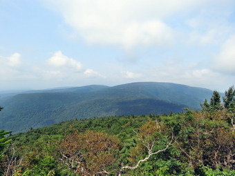 After the first .2 miles the entire hike to the Plateau lookout and the plateau is all up. There are a few switchbacks but they don't do much to help. There isn't much of a view on the way up except in two or three areas where there are slides. We could hear the water in the reek that runs parallel to the trail but couldn't see much of it as we ascended. After a short ascent, Bryce climbed on a big rock and Sheila hopped up beside him. I took some shots before we started to tackle the trail in earnest. It was already getting warmer and the humidity was increasing. I was seating profusely but most of it was from the physical exertion. The trail is shaded in most places and there was a slightly breeze which help. There are some Stine steps on the lower ascent but much of the trail is eroded and covered in gavel which slips underfoot. As we neared the top, the trail leveled out some and there were a few springs where Sheila could get a drink. The final ascent was steeper with plenty of large rocks to scramble over which Bryce enjoyed. We finally arrived at the area just below the lookout. There is a vertical ascent that Sheila and Bryce both Made without a problem. I took off my pack and put it and my poles on top. I was able to work my way up but not without some difficulty. The views from the lookout were good even if they were a little hazy. We could see Hunter and the Hunter Ski area. There were also views up and down the notch. I took some picture and then had Bryce and Sheila sit on the viewpoint while I took pictures. It was 11:20 AM and we had taken 90 minutes to do the 1.25 mile ascent. This was slow but the average grade was over 25% with some section approaching 40%! We got a drink and then continued on the Devil's Path toward the summit of Plateau which was 1.9 miles away. We got back on the trail and headed along the plateau which is mostly flat with a few undulations. In about 5 minutes we were at the next lookout looking north toward Kaaterskill High Peak and Round Top. I took some shots of the mountains and another of Bryce perched on a rock. When we returned to the trail, we found a blowdown which seemed to have been across the trail for some time but had not been cleared. It could have easily been cut back with hand tools but no one had bothered. This seems to be the case with more and more Catskill trails!
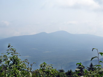 The trail was a little muddy as we walked toward the summit. My intent was to walk passed the Warner Creek Trail to the summit. If we had time, I thought we might walk to the viewpoint toward Sugarloaf. From here we would turn around and retrace our route. After walking about 1.5 miles from the lookout, we came to the Warner Creek Trail on the right. One sign said "Mount Tremper Fire Tower 10.4 miles". I decided this might an interesting car shuttle at some point since the trail head for Mount Tremper is just outside Phoenicia! We passed the turn off and continued about .5 miles to the highest point on the trail. I decided we needed to turn around at this point as I needed to get back for XC practice. We got a drink and a snack before starting back. On the way back I noticed the temperature seemed warmer than ever. Bryce and I were both quite on the return trip as we tried to walk as quickly as possible. I don't know what Bryce was thinking about but I was contemplating the long descent from the lookout. I hoped we could go down more quickly than we had ascended but I knew safety was the primary concern. When we got to the lookout, I noticed that the view was even more hazy than before. I took off my pack and lowered myself down the vertical rock face. I had Bryce lower my pack and poles. He was eager to descend as he likes the rock scrambles and I positioned myself to help but none was needed. From there we tried to hurry down the steep descent just because there isn't much to see. The top part went rather quickly but the steeper sections were miserable. Both Bryce and I slipped several times. I never fell but came very close to several nasty falls. I know I could not do these descents without poles! A few times my right knee let me know that I should be careful about my foot placement. I was very glad when the trail leveled for the final time and we walked out to Rt 214. We crossed the road and were back at the car by 2:45 PM having covered 6.3 miles in 5 hours with and elevation gain of 2170 feet. These times tell me I need to get in better shape to hike the 35's!
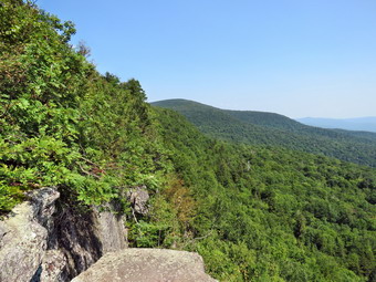
![]()
![]()
![]()
![]()
![]() On Friday, August 24th, I had a hiking date with my grandson Bryce. When I got up in the morning, I was definitely feeling the effects of hiking Dry Brook Ridge the day before with Cindy. We had tried to hurry the return trip to avoid the rain and this had taken a toll on my feet and Achilles tendons. I had planned to take Bryce to Twin Mountain on the Devil's Path but began to think of taken a much shorter, flatter and local hike. Although Bryce was at the house by 8:30 AM, it always seems to take us a while to get ready. I noticed that the temperature was 59 degrees and contemplated wearing long sleeves. In the end, I got dressed in a short-sleeved crew top with a short-sleeved baselayer. I put on a pair of RailRiders hiking pants which are expensive but last along time and have features like deep pockets and a generous cut which I really like. The pants have Velcro closures at the ankles which I hoped would mean I could fend off the ticks which have been very numerous so far this season. I put on my Vasque Taku hiking boots which fit nicely and are now discontinued. I also wore a light windbreaker that I new I could take off at any time. All the while I was getting ready, Sheila was hovering around me making sure I did not forget her. When we left the house at 9:30 AM, the skies were bright and sunny, the humidity was low and there was a slight breeze. We got our gear in the car and Sheila in the backseat and left Livingston Manor. I drove out the DeBruce Road and eventually passed Round Pond. At the end of the road, I turned left on Route 47 and immediately ran into a red light! The construction project to try to keep the Neversink from destroying Rt 47 was still in progress. The wait was short and we were soon back in motion headed toward the Frost Valley YMCA. As I drove I began to think about getting back from Twin in time for XC practice and wondered if this was the day for the long trip. I decided that if there weren't too many cars at the parking area for Giant Ledge we would hike to Giant Ledge and Panther. I had two cell phone apps that help spot the peaks you are viewing and this would give me a good chance to try them out. Panther Mountain itself has limited views but to get there from Route 47 the trail passes over Giant ledge which was a great view of Panther Mountain, the entire Burroughs Range and the valleys below. There were two cars parked at the Biscuit Brook trailhead and about six at the Slide Mountain trailhead. When we arrived at the parking area on Route 47 at 10:05 AM there were only two cars parked there so I pulled in to park and explained the change to Bryce. He didn't mind at all and neither did Sheila. We got started pretty quickly by crossing the road and headed out on the trail at 10:15 AM. A check of the temperature on the car showed 68 degrees so I ditched my jacket but Bryce elected to keep his on. The trail was pretty wet from the rains the previous few days and there were definitely areas of deep mud. I let Sheila off the leash almost immediately after crossing the road and she was behaving by staying on the trail. As we crossed the bridge over the small stream, there was a good volume of water running in the stream. Bryce and Sheila were setting a good pace but I was feeling the effects of the day before! I forgot how annoying the many rocks that cover the trail to the turnoff can be! In addition, there are several short climbs and each one seems to be the last. Despite the fact that I had been hiking, I noticed that making good time up the climbs was tiring although I enjoyed the elevation gain. We finished the sixth short climb and arrived at the turn to Giant Ledge and Panther at about 10:50 AM. I didn't feel like we were going slow but it took 35 minutes to walk the .75 miles from the road, one of our slower times. We turned left to head toward Giant Ledge.
On Friday, August 24th, I had a hiking date with my grandson Bryce. When I got up in the morning, I was definitely feeling the effects of hiking Dry Brook Ridge the day before with Cindy. We had tried to hurry the return trip to avoid the rain and this had taken a toll on my feet and Achilles tendons. I had planned to take Bryce to Twin Mountain on the Devil's Path but began to think of taken a much shorter, flatter and local hike. Although Bryce was at the house by 8:30 AM, it always seems to take us a while to get ready. I noticed that the temperature was 59 degrees and contemplated wearing long sleeves. In the end, I got dressed in a short-sleeved crew top with a short-sleeved baselayer. I put on a pair of RailRiders hiking pants which are expensive but last along time and have features like deep pockets and a generous cut which I really like. The pants have Velcro closures at the ankles which I hoped would mean I could fend off the ticks which have been very numerous so far this season. I put on my Vasque Taku hiking boots which fit nicely and are now discontinued. I also wore a light windbreaker that I new I could take off at any time. All the while I was getting ready, Sheila was hovering around me making sure I did not forget her. When we left the house at 9:30 AM, the skies were bright and sunny, the humidity was low and there was a slight breeze. We got our gear in the car and Sheila in the backseat and left Livingston Manor. I drove out the DeBruce Road and eventually passed Round Pond. At the end of the road, I turned left on Route 47 and immediately ran into a red light! The construction project to try to keep the Neversink from destroying Rt 47 was still in progress. The wait was short and we were soon back in motion headed toward the Frost Valley YMCA. As I drove I began to think about getting back from Twin in time for XC practice and wondered if this was the day for the long trip. I decided that if there weren't too many cars at the parking area for Giant Ledge we would hike to Giant Ledge and Panther. I had two cell phone apps that help spot the peaks you are viewing and this would give me a good chance to try them out. Panther Mountain itself has limited views but to get there from Route 47 the trail passes over Giant ledge which was a great view of Panther Mountain, the entire Burroughs Range and the valleys below. There were two cars parked at the Biscuit Brook trailhead and about six at the Slide Mountain trailhead. When we arrived at the parking area on Route 47 at 10:05 AM there were only two cars parked there so I pulled in to park and explained the change to Bryce. He didn't mind at all and neither did Sheila. We got started pretty quickly by crossing the road and headed out on the trail at 10:15 AM. A check of the temperature on the car showed 68 degrees so I ditched my jacket but Bryce elected to keep his on. The trail was pretty wet from the rains the previous few days and there were definitely areas of deep mud. I let Sheila off the leash almost immediately after crossing the road and she was behaving by staying on the trail. As we crossed the bridge over the small stream, there was a good volume of water running in the stream. Bryce and Sheila were setting a good pace but I was feeling the effects of the day before! I forgot how annoying the many rocks that cover the trail to the turnoff can be! In addition, there are several short climbs and each one seems to be the last. Despite the fact that I had been hiking, I noticed that making good time up the climbs was tiring although I enjoyed the elevation gain. We finished the sixth short climb and arrived at the turn to Giant Ledge and Panther at about 10:50 AM. I didn't feel like we were going slow but it took 35 minutes to walk the .75 miles from the road, one of our slower times. We turned left to head toward Giant Ledge.
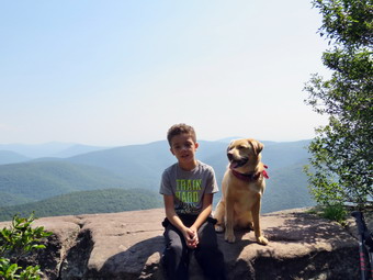 The trail after the turn was also wet and muddy in spots but we made use of the stepping stones along the way. When the climb began I pushed my pace as best I could to keep up with Bryce and Sheila. I pointed out to Bryce some areas where thee are limited views which are better in the winter. When we got to the last field of rocks with the a rocky climb after it, Bryce was impressed but really liked it. It seemed he was trying to take the more difficult paths while I was just trying to survive. We climbed up the last rocky ascent and walked to the first lookout arriving at about 11:25 AM after the 1.5 mile climb. There were two women relaxing on the first viewpoint so I leashed Sheila to a tree. I got out my camera to take some pictures as the skies were mostly clear and full of puffy white clouds. I took variety of pictures and then got out my iPhone to test out the Peak Finder and Peakvisor apps. Both apps produce an outline of the peaks visible from your viewpoint by using the GPS coordinates and compass heading of your phone. Peak Finder seemed to be a little office can be due to the inaccuracies of the GPS system and the compass declination. Peakvisor produces a transparent outline which it overlays on the view from your camera. The overlay can be adjusted so that it matches the view more accurately. Both apps need some instructions and a way to filter out peaks of certain heights and distances. They both showed Mount Frisell, the highest point in Connecticut, which is out there somewhere but certainly too far away to see! I liked Peakvisor a little better. I found that the "bump" visible between Slide and Cornell is Friday. As I suspected the most prominent peaks from Panther eastward are those found on the Devil's Path. The database for these apps must be pretty big because many smaller hills were listed. We got a drink and were ready to leave when I could hear other hikers approaching. Two teenage boys appeared to take in the view. I talked to them and found out they lived on Long Island less than a mile from where we lived when I taught there! I put Sheila on her leash and we left the first lookout to go back to the main trail along the ledges. Sheila is fearless about heights and sometimes scares me a little when she walks right to the edge of the cliffs and looks down! As we hiked along the ledges, we stopped at a few more of the major lookouts but I limited my photography as the views do not change much. Sheila walked to the edge of most of the lookouts. I decided that although I was tired we would go over to Panther which pleased Bryce. We descended into the col between Giant Ledge and Panther, walked flat for a little while and then started the climb up Panther. Bryce loved the descent through the rocks and I pointed out a spot where I had bushwhacked down below the ledges several times. Parts of the Panther trail get a little steep at times but there always seems to be a switchback or flatter area. The trail was mostly dry with a few muddy spots and some slippery rocks. I seemed to me that it had gotten warmer and more humid but that may just have been me being very tired. We continued up the trail with Sheila checking out some of the paths that lead to limited viewpoints along the way. We stopped at one and walked out to a rock which had a good view of Giant Ledge and Slide with only a few small trees in the way. I took some pictures before we went back to the main trail. We were soon up the steeper climbs with only a final, short ascent of Panther to go. We met a group of three Asian hikers headed down the mountain. We acknowledged each other. I was surprised that they all were wearing long sleeves! The last part of the ascent on Panther isn't too long or steep but it was all I could manage. Along the way we had to avoid some more mud. As we
passed the lookout just before the summit, I saw a pack on the rock. Sheila went to inspect which is when I saw a camper in a hammock on the lookout! I am not surprised much any more about how inconsiderate people are but this did cause me to wonder! There is no explaining these actions except to understand that people are only concerned about themselves. We arrived at the summit of Panther at 1:05 PM after hiking 3.2 miles. The view from the summit has been improved by the removal of some of the trees blocking the view. I took a couple of shots of the scenery. Bryce and I ate some lunch and got a drink. We walked back to the viewpoint just below the summit and I leashed Sheila to a tree so she would not disturb the person in the hammock. We ascended the rock which acts as the lookout and I took a few shots of the scenery. We descended the rock and went back to where Sheila was tethered. I released here and consulted my watch. I knew we had to make good time on the way down and limit the number of stops. Bryce and Sheila were very energetic as we turned back to head down the mountain.
The trail after the turn was also wet and muddy in spots but we made use of the stepping stones along the way. When the climb began I pushed my pace as best I could to keep up with Bryce and Sheila. I pointed out to Bryce some areas where thee are limited views which are better in the winter. When we got to the last field of rocks with the a rocky climb after it, Bryce was impressed but really liked it. It seemed he was trying to take the more difficult paths while I was just trying to survive. We climbed up the last rocky ascent and walked to the first lookout arriving at about 11:25 AM after the 1.5 mile climb. There were two women relaxing on the first viewpoint so I leashed Sheila to a tree. I got out my camera to take some pictures as the skies were mostly clear and full of puffy white clouds. I took variety of pictures and then got out my iPhone to test out the Peak Finder and Peakvisor apps. Both apps produce an outline of the peaks visible from your viewpoint by using the GPS coordinates and compass heading of your phone. Peak Finder seemed to be a little office can be due to the inaccuracies of the GPS system and the compass declination. Peakvisor produces a transparent outline which it overlays on the view from your camera. The overlay can be adjusted so that it matches the view more accurately. Both apps need some instructions and a way to filter out peaks of certain heights and distances. They both showed Mount Frisell, the highest point in Connecticut, which is out there somewhere but certainly too far away to see! I liked Peakvisor a little better. I found that the "bump" visible between Slide and Cornell is Friday. As I suspected the most prominent peaks from Panther eastward are those found on the Devil's Path. The database for these apps must be pretty big because many smaller hills were listed. We got a drink and were ready to leave when I could hear other hikers approaching. Two teenage boys appeared to take in the view. I talked to them and found out they lived on Long Island less than a mile from where we lived when I taught there! I put Sheila on her leash and we left the first lookout to go back to the main trail along the ledges. Sheila is fearless about heights and sometimes scares me a little when she walks right to the edge of the cliffs and looks down! As we hiked along the ledges, we stopped at a few more of the major lookouts but I limited my photography as the views do not change much. Sheila walked to the edge of most of the lookouts. I decided that although I was tired we would go over to Panther which pleased Bryce. We descended into the col between Giant Ledge and Panther, walked flat for a little while and then started the climb up Panther. Bryce loved the descent through the rocks and I pointed out a spot where I had bushwhacked down below the ledges several times. Parts of the Panther trail get a little steep at times but there always seems to be a switchback or flatter area. The trail was mostly dry with a few muddy spots and some slippery rocks. I seemed to me that it had gotten warmer and more humid but that may just have been me being very tired. We continued up the trail with Sheila checking out some of the paths that lead to limited viewpoints along the way. We stopped at one and walked out to a rock which had a good view of Giant Ledge and Slide with only a few small trees in the way. I took some pictures before we went back to the main trail. We were soon up the steeper climbs with only a final, short ascent of Panther to go. We met a group of three Asian hikers headed down the mountain. We acknowledged each other. I was surprised that they all were wearing long sleeves! The last part of the ascent on Panther isn't too long or steep but it was all I could manage. Along the way we had to avoid some more mud. As we
passed the lookout just before the summit, I saw a pack on the rock. Sheila went to inspect which is when I saw a camper in a hammock on the lookout! I am not surprised much any more about how inconsiderate people are but this did cause me to wonder! There is no explaining these actions except to understand that people are only concerned about themselves. We arrived at the summit of Panther at 1:05 PM after hiking 3.2 miles. The view from the summit has been improved by the removal of some of the trees blocking the view. I took a couple of shots of the scenery. Bryce and I ate some lunch and got a drink. We walked back to the viewpoint just below the summit and I leashed Sheila to a tree so she would not disturb the person in the hammock. We ascended the rock which acts as the lookout and I took a few shots of the scenery. We descended the rock and went back to where Sheila was tethered. I released here and consulted my watch. I knew we had to make good time on the way down and limit the number of stops. Bryce and Sheila were very energetic as we turned back to head down the mountain.
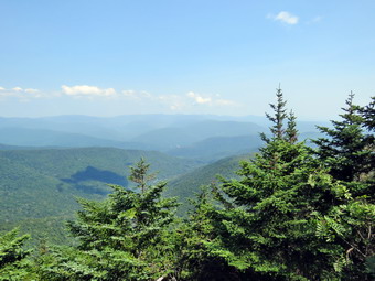 As we descended Panther, Sheila alerted and I saw one woman headed toward us with her dog on a leash. We spoke and she asked me for the distance to the summit and how she would recognize it. I gave her the information and we headed off in opposite directions. I tried to keep a good pace but found the descent almost as difficult as the climb up! It didn't help that Bryce and Sheila were bouncing from rock to rock! We finally made it down to the col and negotiated the muddy areas. Just before the climb back up to Giant Ledge, we stopped to get a drink. As we made the ascent, Bryce was talking freely and I asked him to suspend his questions until we made it to the top. We did meet a dog coming toward us with his owner right behind. She apologized and, in this case, everything was OK. When we had finally made the ascent to Giant Ledge I was happy because I knew that everything else was down or flat. We met a group of people hiking and visiting the various lookouts and they asked about the viewpoints. I gave them some information knowing that there could be more groups along the way as Giant Ledge is very popular. As we passed the first lookout, we could hear a large number of people talking. We finally got to the descent off the Ledge and I could see a young couple ahead of us coming up the rocky climb. They seemed to be arguing about which way to go which was funny since there is no "right" way. We passed them and continued down the rocky slope. We met two young ladies headed up the trail and I directed Sheila off the trail and told her to sit until they passed us. The flatter portion of the trail seemed to last a long time as we used the stepping stones to avoid the mud as much as possible. We made the right turn at the trail and started down the numerous rocky descents. By this time my feet were screaming and the descents were agony. As we neared the bridge over the small stream, we met two young men coming up the trail. As soon as we neared the bridge, Sheila ran toward the stream and jumped in to cool herself and get a drink. I let her have a few minutes before calling her back up to the trail. We walked out to near the trail register where I out her on her leash. We walked out to the road and crossed to the parking lot which was now full with some cars parked along the road. We were back at the car at 3:45 PM having covered 6.4 miles in 5 hours and 30 minutes including numerous stops adding up to just over and hour. The elevation gain was 2150 feet.I was satisfied at the accomplishment but knew I needed at least a day to recover!
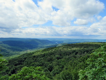
![]()
![]()
![]()
![]()
![]() On Thursday, August 23rd, I had some time to hike on what was forecast to be a beautiful, sunny day with highs near 80 degrees. I asked Cindy if she wanted to go and she said "Yes"> We decided to go to Margaretville and hike to the viewpoint on Dry Brook Ridge from Hill Road. I returned from my men's Bible study group at 8:30 AM and wanted to get going immediately. I began to get ready but somehow we didn't leave Livingston Manor until just after 10:00 AM. I got dressed in a short-sleeved crew top with a short-sleeved baselayer. I put on a pair of RailRiders hiking pants which are expensive but last along time and have features like deep pockets and a generous cut which I really like. The pants have Velcro closures at the ankles which I hoped would mean I could fend off the ticks which have been very numerous so far this season. I put on my Vasque Taku hiking boots which fit nicely and are now discontinued. All the while I was getting ready, Sheila was hovering around me making sure I did not forget her. When we left the house, the skies were bright and sunny, the humidity was low and there was a slight breeze. We got our gear in the car and Sheila in the backseat and left Livingston Manor. I knew Cindy wanted to avoid the back roads as much as possible so I headed toward Roscoe on State Route 17. I got off at the Roscoe exit and headed north toward Downsville on Route 206. The road was in good shape and we were soon at the Pepacton Reservoir. Here I turned right onto Route 30 and continued to the Shavertown Bridge. I turned right on BWS 8 and followed it until it became BWS 9. Where the road changed to BWS 10 at the intersection with Barkaboom Road, I turned left. I followed BWS 10 until it changed to Southside Road just outside Margaretville. I continued on Southside Road to Huckleberry Brook Road where I turned right. Shortly after the turn I turned left on Hill Road and 1.3 miles to the parking pulloff on the right. The temperature was 68 degrees when I parked and there was a breeze blowing. The skies were still blue with some bright sun and puffy white clouds. As we were getting ready another car pulled into the lot and a couple began to get ready to hike the same trail we were doing. We wanted to get ahead of the other couple so that I did not have to keep Sheila on her leash so we started off at a very quick pace. We were both surprised that the trail was soaked with standing water at the beginning which is something I had never seen before. We crossed the road and began our hike at 11:00 AM. The first part of the hike is a nice wide trail that ascends through a red pine plantation. The ascent continues for about 1.9 miles when the trail levels off after gaining 1130 feet. I began to warm up immediately because of the climb and also found I was a little winded from the lack of hiking Fast and on steeper trails. From the sound of Cindy's breathing she was having a similar reaction. As we walked, there were several blowdowns across the trail from near the bottom until the trail leveled. We moved some branches off the trail but others required tools to remove. It was also obvious that there had been a lot of rain on the trail as there were huge piles of pine needles in several spots. The trail had drained nicely and was almost dry on the steeper grades. The sun through the pines was beautiful but the breeze kept the temperature down and the low humidity completed the almost perfect conditions. After passing through the pines, we entered a predominantly hardwood forest before passing again through some pines. Sheila seemed to delight in racing away from me and then careening headlong back toward me. There were a lot of animal tracks along the trail and some crossing it and Sheila was busy investigating these tracks. After 1.9 miles, the trail leveled off and turned almost 90 degrees from northeast to southeast. We were glad the climbing was done at least for a few minutes. We walked across a flat area dipping down a little to the junction with the blue Dry Brook Ridge Trail at 2.3 miles. We stopped and we got a much needed drink and a bar.
On Thursday, August 23rd, I had some time to hike on what was forecast to be a beautiful, sunny day with highs near 80 degrees. I asked Cindy if she wanted to go and she said "Yes"> We decided to go to Margaretville and hike to the viewpoint on Dry Brook Ridge from Hill Road. I returned from my men's Bible study group at 8:30 AM and wanted to get going immediately. I began to get ready but somehow we didn't leave Livingston Manor until just after 10:00 AM. I got dressed in a short-sleeved crew top with a short-sleeved baselayer. I put on a pair of RailRiders hiking pants which are expensive but last along time and have features like deep pockets and a generous cut which I really like. The pants have Velcro closures at the ankles which I hoped would mean I could fend off the ticks which have been very numerous so far this season. I put on my Vasque Taku hiking boots which fit nicely and are now discontinued. All the while I was getting ready, Sheila was hovering around me making sure I did not forget her. When we left the house, the skies were bright and sunny, the humidity was low and there was a slight breeze. We got our gear in the car and Sheila in the backseat and left Livingston Manor. I knew Cindy wanted to avoid the back roads as much as possible so I headed toward Roscoe on State Route 17. I got off at the Roscoe exit and headed north toward Downsville on Route 206. The road was in good shape and we were soon at the Pepacton Reservoir. Here I turned right onto Route 30 and continued to the Shavertown Bridge. I turned right on BWS 8 and followed it until it became BWS 9. Where the road changed to BWS 10 at the intersection with Barkaboom Road, I turned left. I followed BWS 10 until it changed to Southside Road just outside Margaretville. I continued on Southside Road to Huckleberry Brook Road where I turned right. Shortly after the turn I turned left on Hill Road and 1.3 miles to the parking pulloff on the right. The temperature was 68 degrees when I parked and there was a breeze blowing. The skies were still blue with some bright sun and puffy white clouds. As we were getting ready another car pulled into the lot and a couple began to get ready to hike the same trail we were doing. We wanted to get ahead of the other couple so that I did not have to keep Sheila on her leash so we started off at a very quick pace. We were both surprised that the trail was soaked with standing water at the beginning which is something I had never seen before. We crossed the road and began our hike at 11:00 AM. The first part of the hike is a nice wide trail that ascends through a red pine plantation. The ascent continues for about 1.9 miles when the trail levels off after gaining 1130 feet. I began to warm up immediately because of the climb and also found I was a little winded from the lack of hiking Fast and on steeper trails. From the sound of Cindy's breathing she was having a similar reaction. As we walked, there were several blowdowns across the trail from near the bottom until the trail leveled. We moved some branches off the trail but others required tools to remove. It was also obvious that there had been a lot of rain on the trail as there were huge piles of pine needles in several spots. The trail had drained nicely and was almost dry on the steeper grades. The sun through the pines was beautiful but the breeze kept the temperature down and the low humidity completed the almost perfect conditions. After passing through the pines, we entered a predominantly hardwood forest before passing again through some pines. Sheila seemed to delight in racing away from me and then careening headlong back toward me. There were a lot of animal tracks along the trail and some crossing it and Sheila was busy investigating these tracks. After 1.9 miles, the trail leveled off and turned almost 90 degrees from northeast to southeast. We were glad the climbing was done at least for a few minutes. We walked across a flat area dipping down a little to the junction with the blue Dry Brook Ridge Trail at 2.3 miles. We stopped and we got a much needed drink and a bar.
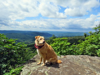 As we turned right on this trail, I noticed that all the signs were in poor condition and had incorrect distances. One sign that was broken in half said the Hill Road parking was 1.7 miles away. I had to laugh! I expect distances to vary some but .5 miles is a pretty big gap. Another sign stated it was 5.5 miles to Millbrook Road which is pretty close but also indicated that the lean-to was 3.3 miles away. This is about .8 miles short! We started along the ridge trail which follows the edge until about 2.7 miles where it veers away and heads a little to the east and northeast. Initially the trail ascends a small bump and then descends the other side before leveling off for a while. The level area of the trail was very wet with standing water and mud and we had to negotiate around several of these areas. This would continue to be a problem for most of the rest of the way to the lookouts. The first two ascents were slippery from the rain and mud but soon we were climbing the last of three short ascents to the area of the lookout. The total elevation gain from the trail junction to the lookouts is 285 feet. From 2.95 miles to the lookout the trail gains just under 200 feet in elevation and begins to follow the edge of the escarpment turning almost due south. Just short of the lookouts Cindy decided she was not going to go any further. I knew it was less than a quarter mile but I also knew it was no use to try to convince her. I was very disappointed as Sheila and I headed off toward the viewpoint. The brush, briars and nettles had been overgrowing the trail in many spots but we had to push our way through the brush to get to the spur trail to the viewpoint. When we arrived at the viewpoint at 1:10 PM, the breeze was blowing slightly and the sky was blue with puffy white clouds. The Pepacton Reservoir was clearly visible and the view showed the high volume of water. Everything was very green I got out my camera to take some pictures including a few of Sheila posed on the rocks. I took some shots in all directions and zoomed in on the reservoir. I got a drink and then started the walk back to the car which was all flat or downhill. In a short distance I met the couple who had started after us and seemed glad they were at the lookout. A little further on I found Cindy sitting on a rock and she joined us for the trip back. The trip back to the trail junction went more quickly than I had expected but avoiding the small ponds along the way was annoying. We began to notice that the skies were getting darker but I knew the forecast had not mentioned even the possibility of rain. At that moment it began to sprinkle, the it began to rain. I decided to put on my pack cover and Cindy donned a light rain jacket. I never wear rainware unless it OS cold since I would rather be bathed in the fresh rain rather than my own sweat. Sometimes putting on the pack cover "causes" the rain to stop but this time it had the opposite effect. It started to pour! We didn't bother to stop again at the trail junction but simply turned left to head back down the trail to the parking area. The skies looked bluer up ahead but it seemed the rain clouds were following us. Despite the danger of descending quickly we both set very quick pace using our poles to maximum advantage. It wasn't too long until the rain abated and then stopped but by this time I was very wet an the vegetation along the trail was also soaked. The water on the plants transferred directly to my pants and boots as the trail desperately needed trimming. We entered the red pines as the skies began to cloud up again. I could see the road ahead and hoped the rain would hold off but it poured one more time before we got to the car. We arrived back at the car at 2:45 PM. We had hiked 6.5 miles in 3 hours and 40 minutes with an elevation gain of 1640 feet. The trip down was about 30 minutes shorter than the trip up! I decided to use the same route home that I had used on the way out. I had planned to stop to take some pictures of the reservoir but I was just too tired to do that and drove straight home.
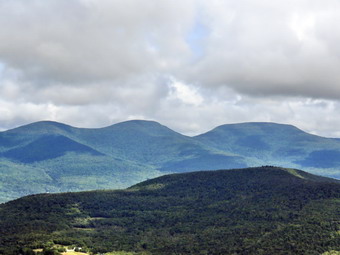
![]()
![]()
![]()
![]()
![]() On Monday, August 20thI wanted to do a 3500 foot peak with my grandson Bryce. We had already hiked Slide Mountain, the highest peak in the Catskills, and I thought hiking the second highest would be appropriate. I had planned to hike this peak last Wednesday but we visited a series of waterfalls instead which proved to be quite interesting. Hunter has a fire tower at the summit which is necessary as there are no views from the ground. I decided we would use the trail from Spruceton which is relatively easy and has a nice view from the John Robb lean-to along the way. The forecast was for early morning clouds which were supposed to clear by the late morning and there was no rain predicted. Bryce arrived around 7:30 AM and had a little more breakfast as I got ready to go. The temperature was in the high 50's as I was getting ready so Bryce and I both decided to wear light windbreakers. I got dressed in a short-sleeved crew top with a short-sleeved baselayer. I put on a pair of RailRiders hiking pants which are expensive but last along time and have features like deep pockets and a generous cut which I really like. The pants have Velcro closures at the ankles which I hoped would mean I could fend off the ticks which have been very numerous so far this season. I put on my Vasque Taku hiking boots which fit nicely and are now discontinued. We got our gear in the car and got Sheila and Bryce in the backseat. Bryce insisted on taking a pair of poles which I didn't think he would need but I knew he wanted to be equipped like his grandfather. I had wanted to leave as early as possible but we didn't leave Livingston Manor until around 8:30 AM with the temperature in the lower 60's. I drove out DeBruce Road all the way to the end and the turned left onto Route 47. We immediately ran into the road crews who were trying to restore the right lane of the road which had been washed away by the high waters of the Neversink River. The wait wasn't long and we were soon passing by the Frost Valley YMCA. I continued on Rt 47 passing the trailheads at Biscuit Brook, Slide Mountain and Giant Ledge/Panther. There were a few cars at each spot but they didn't look very crowded. At Route 28 I turned right and drove a few miles before turning left and heading north on Route 42 toward Lexington. We passed the parking area for Halcott and I turned right on Spruceton Road to head out to the parking area for Hunter. I drove out Spruceton Road and turned left into the parking area. There was only one car as we got ready to hike with the temperature at 62 degrees. The cool temperature and low humidity seemed ideal for a hike. I set my Suunto Traverse GPS watch and my Garmin 64st handheld unit and we were ready to go.
On Monday, August 20thI wanted to do a 3500 foot peak with my grandson Bryce. We had already hiked Slide Mountain, the highest peak in the Catskills, and I thought hiking the second highest would be appropriate. I had planned to hike this peak last Wednesday but we visited a series of waterfalls instead which proved to be quite interesting. Hunter has a fire tower at the summit which is necessary as there are no views from the ground. I decided we would use the trail from Spruceton which is relatively easy and has a nice view from the John Robb lean-to along the way. The forecast was for early morning clouds which were supposed to clear by the late morning and there was no rain predicted. Bryce arrived around 7:30 AM and had a little more breakfast as I got ready to go. The temperature was in the high 50's as I was getting ready so Bryce and I both decided to wear light windbreakers. I got dressed in a short-sleeved crew top with a short-sleeved baselayer. I put on a pair of RailRiders hiking pants which are expensive but last along time and have features like deep pockets and a generous cut which I really like. The pants have Velcro closures at the ankles which I hoped would mean I could fend off the ticks which have been very numerous so far this season. I put on my Vasque Taku hiking boots which fit nicely and are now discontinued. We got our gear in the car and got Sheila and Bryce in the backseat. Bryce insisted on taking a pair of poles which I didn't think he would need but I knew he wanted to be equipped like his grandfather. I had wanted to leave as early as possible but we didn't leave Livingston Manor until around 8:30 AM with the temperature in the lower 60's. I drove out DeBruce Road all the way to the end and the turned left onto Route 47. We immediately ran into the road crews who were trying to restore the right lane of the road which had been washed away by the high waters of the Neversink River. The wait wasn't long and we were soon passing by the Frost Valley YMCA. I continued on Rt 47 passing the trailheads at Biscuit Brook, Slide Mountain and Giant Ledge/Panther. There were a few cars at each spot but they didn't look very crowded. At Route 28 I turned right and drove a few miles before turning left and heading north on Route 42 toward Lexington. We passed the parking area for Halcott and I turned right on Spruceton Road to head out to the parking area for Hunter. I drove out Spruceton Road and turned left into the parking area. There was only one car as we got ready to hike with the temperature at 62 degrees. The cool temperature and low humidity seemed ideal for a hike. I set my Suunto Traverse GPS watch and my Garmin 64st handheld unit and we were ready to go.
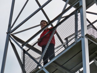 The initial part of the trail has a gentle grade and parallels Hunter Brook which had quite a bit of water. The trail crosses the brook on a bridge at .5 miles and shortly after that makes a more than 90 degree turn as the grade begins to increase. I pointed out the well-defined head path at the turn and told Bryce that there was a bushwhack to Rusk Mountain in that direction. I wondered how well defined it remained further toward the summit. As we made the turn and the grade increased the trail got a little wetter but there still wasn't much mud or water. There were a few blowdowns across the trail which looked recent. I told Bryce to look to our right to see if he could spot the Westkill Ridge through the trees. It was hard to see much and when we could get a glimpse there was a lot of haze hanging on the mountains. I took off my windbreaker as I was getting warm but Bryce kept his on. I set a steady but slow pace and had to slow Bryce down several times. He is capable of doing the entire hike at an accelerated pace but I am not! The sun was out and the temperature was beginning to rise as we hiked up the trail. As we hiked Sheila was following animal tracks in many different directions. The trail was a little longer than I remembered but we made the saddle between Hunter and the Rusk ridge at 10:50 AM after hiking 1.7 miles. I contemplated the fact that we were half way through the trip as far as mileage went but I knew that the hardest part was yet to come. The trail from the turn to the summit averages a 12% grade but this includes spots where trail levels off. Some pieces of the ascent are around 20%! We made the right turn up the mountain and I immediately noticed that the grade increased. In a short distance we began to encounter water flowing down the trail and areas where the trail was highly eroded from the recent rains. We kept a good pace which had me sweating and breathing a little more than I had been. We continued to climb and came to the area just below the spring which was wet from the overflow. The spur trail to the lean-to was a little father away than I remembered and when we came to it I decided to stick to the original plan and continue to the summit. At 11:30 AM we passed the trail to the left that goes to the Colonel's Chair, the top of the Hunter Mountain ski complex. We had hiked 2.5 miles and still had about a mile and 450 feet of elevation to go! Even though we had stopped several times there were no signs of anyone following us on the trail. Bryce pointed out an almost perfect spider web just under the sign and I took a shot before continuing on the trail.
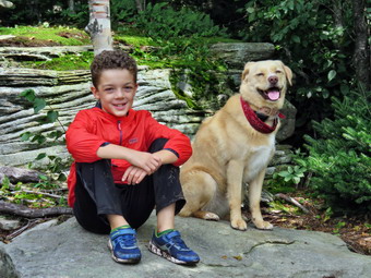 The final mile has a few spots where the trail levels off and a few where there are some sustained climbs. All of the flatter places had standing water and a lot of mud. We walked on the side of the trail as much as we could to stay out of the mud. At one point Bryce pointed out some colorful mushroom on the side of the trail. I took a few pictures of them and also of the trail which was now passing through pine trees as we were above 3500 feet. We passed by a small lookout on the left since I knew better things were to come. We continued on our way hiking the last ascent which was a little steeper and longer than I remembered. Bryce decided to challenge Sheila to a race to the top and they were off. They waited for me at the top and we continued on to the tower clearing. As we approached the tower clearing, I could see there was no one at the cabin but there was one hiker at the top of the tower just under the cab. We walked to the cabin where I dropped my pack by the picnic table. It was noon and we had hiked 3.5 miles. Since I had forgotten a leash for Sheila I connected her to a hiking pole to give Bryce more control. I took my camera and walked to the tower and started to ascend. I could tell when I was just above the treeline as a stiff breeze made me feel very cool. I stopped just below the other hiker and we exchanged a few comments. There was much less haze and clouds than I had expected and the views were very good. I took quite a few pictures in all directions. I took some of the ski slopes and a few of Bryce and Sheila below me. The other hiker and I began to descend together and I walked over to the picnic table. Bryce wanted to climb the tower so I made him promise to be careful and let him do it by himself. I knew that if we went up together Sheila would follow us all the way to the top as she is fearless about ascended and descending steep stairs and seems to love heights! Bryce climbed very deliberately and carefully until he was as far up as he could go. I took a few pictures of him at the top and a few more of him on the way down. Bryce walked back over to the picnic table and we ate some lunch and had a drink. Another hiker arrived and explained she had come up from the ski area. The first male hiker was from Salt Point in Duchess County while the woman was from White Plains! We talked for a while and another group of four hikers arrived and got their views from the tower. After talking to this group for a few minutes Bryce and I decided to leave. We said "Goodbye" and started back down the mountain at 12:30 PM. I thought about doing the loop through the Devil's Acre but decided that trail might be too wet and dangerous. As we started down, we noticed Bryce had forgotten his poles. He ran to get them and it seemed he was back as son as he had left!
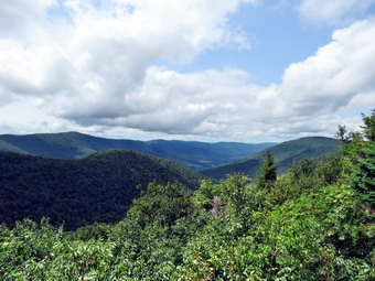 We didn't get very far down the trail before I could hear a group approaching. This group was eight girls and a counselor ROM a Jewish girls camp. We said "Hello" and they asked how much further. I assured them it was much less than a mile. We walked a little farther and another group from the same camp approached asking for the same information. After answering, we continued on the trail avoiding the numerous ponds and mud pits and being careful to watch our step on the loose and wet gravel and rocks. As we approached the trail to the ski lifts, the woman we met at the summit caught up to us and a family group approached. The kids in the group were whining about hiking and I hoped they would pass by quickly. I had to grad Sheila each time because I had forgotten a leash. Once the family passed I let her go and we continued down the slope. To our surprise another member of the group, a teenage boy, came running up the trail toward me. Sheila took exception and barked at him but we passed by quickly. Soon we came to the spur trail to the lean-to and I decided we had to make the visit to let Bryce see the great views. We turned left to visit the lean-to and the lookout over true Spruceton Valley. Bryce enjoyed the fact that the trail squeezes between some rocks and then passes under and overhang. When we got to the lean-to, I dropped my pack to walk out to the lookout. I noticed some sawdust and several carpenter ants apparently working to destroy the lean-to! The view from the lookout was beautiful and I took pictures of the valley. I also snapped some shots of Westkill and Rusk. I had Bryce and Sheila sit on the rocks and took a few photographs of them. After returning to the lean-to for a few more pictures, I shouldered my pack and we headed back out to the main trail. We turned left and carefully made my way down the wet and eroded trail meeting a few more people on the way down. We were soon at the left turn where we picked up the pace down the wide woods road. On the descent to the sharp left turn we met a father an son hiking up with backpacking packs. I told them the lean-to was clear and they said that was where they were headed. We made the left turn and eventually crossed the bridge. I took a few pictures of the brook and some small "falls" along the way. Sheila alerted again and a man approached us pushing mountain bike. I was going to ask what he was doing but decided to continue down the trail. We were back at the parking area at 2:30 PM after hiking 7.1 miles in 4 hours and 35 minutes with an elevation gain of 2040 feet. Our total stopped time was 55 minutes.
On Saturday, August 17th the weather appeared unsettled and I didn't want to go too far from home. My brother-in-law Jeff wanted to get in some hiking so I suggested he come to Livingston Manor. My plan was to go across the street and hike on Round Top perhaps doing some light maintenance that I knew should be done. Jeff agreed to be at my house at 10:00 Am so I got some chores done before he arrived. Jeff arrived a few minutes after 10:00 AM with a complete array of trail maintenance tools! We went inside so that I could get ready. Sheila had rushed out to greet Jeff who is now considered part of her pack and she was reluctant to come back inside. I got ready quickly so that we could get to work. I got dressed in a short-sleeved crew top and a pair of RailRiders hiking pants. These are expensive but last along time and have features like deep pockets and a generous cut which I really like. The pants have Velcro closures at the ankles which I hoped would mean I could fend off the ticks which have been very numerous so far this season. I put on my Vasque Taku hiking boots which fit nicely and are now discontinued. I decided just to carry the tools and forego the pack and hiking poles. Jeff brought his Fiskars loppers and I brought my Fiskars axe and Silky Sugowaza saw. I put Sheila on her leash as we walked out the driveway and crossed the street. We headed for the road behind the church and walked up the hill toward the trailhead. This hill is steep but short and the walk is quite aerobic. Sheila helped me by pulling on her leash. We turned left at the trailhead onto the trail system. I released Sheila from her leash since she always stays close especially on these trails. At the first trail junction we turned right and walked up the gently sloping woods road. Along the way we cut some branches and removed some that were already lying on the trail. At the next trail junction we continued straight ahead toward the summit on the blue trail. This trail had more branches on the ground and more leaning into the trail. We arrived at a larger white birch that I knew was down on the trail. Jeff lopped a few branches and I made one cut through the tree trunk. I removed the upper part of the tree and Jeff pivoted the other section off the trail. We cut a few more branches as we worked our way to the top of the hill and across the summit. We walked down the other side of the hill which was steep and slippery from the rain. When we reached the lower yellow trail junction, we turned right and walked downhill toward the lookout. There wasn't much work to do on this part of the trail. We did stop at the upper lookout and found we could get a limited view through the trees. After a few minutes, we continued down the trail to the first trail junction. The skies appeared to be growing cloudy but I decided we should turn around and walk a small loop to make sure that part of the trail was clear. We walked back up the hill to the viewpoint and followed the yellow trail to the right around the base of Round Top. At the next trail junction we turned right and followed the trail downhill on the old woods road as the skies grew darker. By the time we arrived at the first trail junction, the rain was beginning to fall. We turned left and walked out to the trailhead where I put Sheila on her leash. As we walked down the cemetery hill, the rain began top fall harder and it was clear we were going to get soaked. We walked across the field by the church and down the driveway to the house. We headed inside to dry off. Jeff decided he was going to head home so we said goodbye. By the time he had reached the end of the driveway, the rain had stopped and the sun was shining brightly.
![]() On Wednesday, August 15th we finished visiting and taking pictures at Platte Clove and headed west on Route 23A toward Prattsville. Just east of Prattsville I turned right on Route 23 and rove about a mile north to Red Falls on the Batavia Kill. The falls is easily visible from the road and impossible to miss even when the water level is low. On this day the water level was high and the falls were roaring but the water was a little muddy. I pulled over at the side of the road to park even though the signs indicated no parking was allowed. Once again Cindy elected to stay in the car which was fortunate as there is no alternative parking area. I grabbed my camera and Bryce and I walked back down the road and hopped over the guard rail. Decided to leave Sheila in the car as the roaring water made me nervous! We made our way down an informal path to the edge of the Batavia Kill. There are several levels of rock ledges next to the falls that allow viewing and they were all relatively dry. Bryce voluntarily decided to sit on some rocks as I worked my way down the ledges and downstream until I was almost beyond the bottom of the falls. I decided to take a 40 second video to record the power of the falls. After taking the video, I took some still shots and then worked my way back upstream taking a few pictures as I went including a few of Bryce. At the top of the falls I took a few more shots and then we headed back to the car. I drove west on Route 30 through Grand Gorge, Roxbury and Margaretville and continued on Route 30 toward Downsville. We crossed the Pepacton Reservoir noting that it was filling nicely from the recent rains. I turned left on Route 206 and drove to Roscoe where I picked up State Route 17 for the final get of the journey home. We were back in Livingston Manor at 4:30 PM having left at 9:00 AM. Bryce said he though our 7.5 hour adventure was great!
On Wednesday, August 15th we finished visiting and taking pictures at Platte Clove and headed west on Route 23A toward Prattsville. Just east of Prattsville I turned right on Route 23 and rove about a mile north to Red Falls on the Batavia Kill. The falls is easily visible from the road and impossible to miss even when the water level is low. On this day the water level was high and the falls were roaring but the water was a little muddy. I pulled over at the side of the road to park even though the signs indicated no parking was allowed. Once again Cindy elected to stay in the car which was fortunate as there is no alternative parking area. I grabbed my camera and Bryce and I walked back down the road and hopped over the guard rail. Decided to leave Sheila in the car as the roaring water made me nervous! We made our way down an informal path to the edge of the Batavia Kill. There are several levels of rock ledges next to the falls that allow viewing and they were all relatively dry. Bryce voluntarily decided to sit on some rocks as I worked my way down the ledges and downstream until I was almost beyond the bottom of the falls. I decided to take a 40 second video to record the power of the falls. After taking the video, I took some still shots and then worked my way back upstream taking a few pictures as I went including a few of Bryce. At the top of the falls I took a few more shots and then we headed back to the car. I drove west on Route 30 through Grand Gorge, Roxbury and Margaretville and continued on Route 30 toward Downsville. We crossed the Pepacton Reservoir noting that it was filling nicely from the recent rains. I turned left on Route 206 and drove to Roscoe where I picked up State Route 17 for the final get of the journey home. We were back in Livingston Manor at 4:30 PM having left at 9:00 AM. Bryce said he though our 7.5 hour adventure was great!
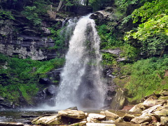
![]() On Wednesday, August 15th we finished visiting and taking pictures at Kaaterskill Falls and headed west on Route 23A toward Hunter. We stopped in Tannersville to refuel the car and ourselves and then continued on Route 23A. Just outside of Tannersville, I turned left on Bloomer Road and then right on County Route 16 or Platte Clove Road. I continued driving passing the Dale Road and Prediger Road trailheads and the Catskill Community. Just after this I pulled over at the side of the road by the Platte Clove Preserve. Parking is no longer allowed here but Cindy was not interested in hiking anymore so she agreed to stay in the car. Unattended vehicles should be parked in the DEC lot about .2 miles east of the Preserve on the left hand side. I grabbed my camera and Bryce and I headed down the Preserve Waterfalls Trail which ends at the bottom of Plattekill Falls. The trail was wet and muddy but we were used to that by now. A short distance form the top the trail turned sharply right. A lookout had been cut out at this point and there was a beautiful view down the clove. There were also some signs that explained the geology and human history of the area. I took pictures of the clove and of Bryce reading the signs. We then followed the trail as it went through some switchbacks down to the creek. The trail had been redone and was good most of the way. The final descent to the stream was a little steep and very wet. I got out the camera and took some photographs of the falls which, like the others on this day, was flowing with a good volume. We walked back up the trail to the cabin and then started out on the Long Path toward the kingpost bridge.
On Wednesday, August 15th we finished visiting and taking pictures at Kaaterskill Falls and headed west on Route 23A toward Hunter. We stopped in Tannersville to refuel the car and ourselves and then continued on Route 23A. Just outside of Tannersville, I turned left on Bloomer Road and then right on County Route 16 or Platte Clove Road. I continued driving passing the Dale Road and Prediger Road trailheads and the Catskill Community. Just after this I pulled over at the side of the road by the Platte Clove Preserve. Parking is no longer allowed here but Cindy was not interested in hiking anymore so she agreed to stay in the car. Unattended vehicles should be parked in the DEC lot about .2 miles east of the Preserve on the left hand side. I grabbed my camera and Bryce and I headed down the Preserve Waterfalls Trail which ends at the bottom of Plattekill Falls. The trail was wet and muddy but we were used to that by now. A short distance form the top the trail turned sharply right. A lookout had been cut out at this point and there was a beautiful view down the clove. There were also some signs that explained the geology and human history of the area. I took pictures of the clove and of Bryce reading the signs. We then followed the trail as it went through some switchbacks down to the creek. The trail had been redone and was good most of the way. The final descent to the stream was a little steep and very wet. I got out the camera and took some photographs of the falls which, like the others on this day, was flowing with a good volume. We walked back up the trail to the cabin and then started out on the Long Path toward the kingpost bridge.
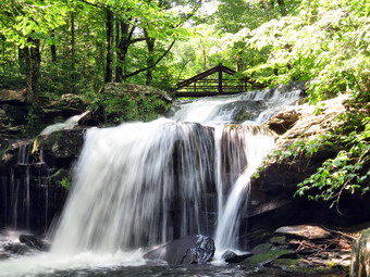 After hiking a short distance, we turned left and followed a path down to the streambed. Again, the last few feet were very steep so I asked Bryce to stay higher on the bank. I worked my way down to a rock shelf that jutted out into stream and carefully positioned myself to take pictures of Old Mill Falls. The falls has two steps which drop about 16 feet. Upstream from the falls is the kingpost bridge that crosses the stream. The lighting was such that I could take pictures with a stetting that allowed me to soften the water flowing over the falls. I took some wider angle shots and then zoomed in on the falls. I hoped some of the shots would show the "softer water and the bridge in the background. I carefully turned around on the rock and was surprised to see how close I was to the top of Plattekill Falls. These falls drop more than 50 feet onto jagged rocks. I took a few shots and then returned to Bryce. We walked back up to the marked trail and then back to the car. I had at least three more waterfalls in mind in Delaware County but decided the last one we would visit would be Red Falls just east of Prattsville. I retraced my route to Route 23A and drove west through Hunter toward Prattsville.

![]() On Wednesday, August 15th we finished visiting and taking pictures at Diamond Notch Falls and headed north on Route 42 toward Lexington. In Lexington a highway crew was working on the beige but we only had to wait a few minutes. I turned right on Route 23A and headed toward Hunter and Tannersville. Both towns were moderately busy but we passed through both without trouble. After driving through Haines Falls we began to descend the hill toward where Spruce Creek crosses the road. I wanted to park in the area just above this so that we could hike up to the falls ROM the bottom rather than down from the top. This way we could also take in Bastion Falls which is adjacent to the bridge over the creek on Route 23A. When we arrived at the parking area, we found it overflowing with cars so I turned around and headed back up the hill. I turned right on North Lake Road which leads to North-South Lake Campgrounds. I watched for Laurel House Road and turned right to drive down to the newer upper parking area. This parking area was also full but I was able to find a spot. I thought perhaps we would just visit the viewing platform to see what the falls looked like and then leave due to the number of people that were visiting the falls. We got out of the car and immediately noticed that it was both hot and humid! We began our walk following the signs on the wide paths which are covered in small gravel over a hard base. The paths have been constructed to have a very gradual grade and are ADA compliant. On the way to the platform I could see that the bridge to the other side of the creek had been completed. Previously hikers would have to pick their way across the stream which would have been almost impossible on this day given the high water level. The only other choice was to park in the Schutt Road lot but that would mean being unable to access the platform. Soon we were at the viewing platform and I was surprised there were so few people there. I attached Sheila to a tree by her leash, put down my pack and took out the camera. I walked down to the platform and got a great view of the upper falls which had so much volume that the water was shooting off into mid-air. I took pictures of the falls from several angles and with different settings. I also took some pictures down the clove with the Devil's Path to the west and Kaaterskill High Peak across from the falls. After taking the pictures, I put the camera back in my pack and retried Sheila. We began to walk up the trail turning right at the junction so that we could cross the creek on the bridge. I had made the decision to hike down to the lower falls!
On Wednesday, August 15th we finished visiting and taking pictures at Diamond Notch Falls and headed north on Route 42 toward Lexington. In Lexington a highway crew was working on the beige but we only had to wait a few minutes. I turned right on Route 23A and headed toward Hunter and Tannersville. Both towns were moderately busy but we passed through both without trouble. After driving through Haines Falls we began to descend the hill toward where Spruce Creek crosses the road. I wanted to park in the area just above this so that we could hike up to the falls ROM the bottom rather than down from the top. This way we could also take in Bastion Falls which is adjacent to the bridge over the creek on Route 23A. When we arrived at the parking area, we found it overflowing with cars so I turned around and headed back up the hill. I turned right on North Lake Road which leads to North-South Lake Campgrounds. I watched for Laurel House Road and turned right to drive down to the newer upper parking area. This parking area was also full but I was able to find a spot. I thought perhaps we would just visit the viewing platform to see what the falls looked like and then leave due to the number of people that were visiting the falls. We got out of the car and immediately noticed that it was both hot and humid! We began our walk following the signs on the wide paths which are covered in small gravel over a hard base. The paths have been constructed to have a very gradual grade and are ADA compliant. On the way to the platform I could see that the bridge to the other side of the creek had been completed. Previously hikers would have to pick their way across the stream which would have been almost impossible on this day given the high water level. The only other choice was to park in the Schutt Road lot but that would mean being unable to access the platform. Soon we were at the viewing platform and I was surprised there were so few people there. I attached Sheila to a tree by her leash, put down my pack and took out the camera. I walked down to the platform and got a great view of the upper falls which had so much volume that the water was shooting off into mid-air. I took pictures of the falls from several angles and with different settings. I also took some pictures down the clove with the Devil's Path to the west and Kaaterskill High Peak across from the falls. After taking the pictures, I put the camera back in my pack and retried Sheila. We began to walk up the trail turning right at the junction so that we could cross the creek on the bridge. I had made the decision to hike down to the lower falls!
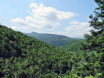 As I crossed the bridge I could see some irresponsible people wading and swimming in the creek below. The DEC has done a good job of putting up fencing, posting signs and installing steps but it is impossible to eliminate the stupidity of some people. Visitors are still being rescued from the falls area, some with serious injuries, because they ignore warnings and lack common sense. After crossing the bridge, we started out on the blue Escarpment Trail which is a more typical Catskill trail with rocks and roots. It was very wet and muddy and all the rocks and roots were slippery. There were people walking ahead of us and some coming toward us. Most understood that it is best to walk to the right but a few did not know this "rule". I was not surprised but had to shake my head that so many people were wearing sandals or some other inappropriate footwear. Two girls passed us in what looked like new, white tennis shoes! I had Sheila on her leash and she was behaving very well obeying all my commands. There aren't too many other dogs but as we were hiking a dog did approach us with the owner right behind apologizing for not catching her dog in time. I remained quiet but wanted to point out that the rules in this area REQUIRED that dogs be leashed at all times! We continued on the Escarpment trail gaining a little elevation until we were about .15 miles from the creek. At this point the yellow spur trail to the falls turned off to the right and we started down the trail which continued to be wet and muddy. In some spots water ran down the trail and in others smalls reams crossed the trail. There was a steady stream of people coming up and a number, like us, headed down the path. We had been headed east but eventually the trail turned almost 180 degrees to head west.
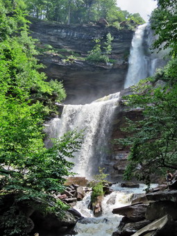 Somewhere in this area we began to encounter the stone steps that had been installed until eventually the trail was all steps. Almost a mile from the creek another spur trail turned right. The trail was narrow, slippery and hugged the rock on the right. It lead out to the area at the bottom on the upper falls and the top of the lower drop. We walked out to the end of this path where quite a few people were gathered. The spray was coming off the upper falls and being blown by the wind so that it was getting us pretty wet. I took a couple of quick shots but the camera lese was almost immediately covered in spray! We packed up and went back to look for Cindy who had not followed us out. She was not at the junction so we turned right and began to descend the steps to the foot of the lower falls. On the way down I spotted her sitting on a rock waiting for us. I gave Sheila's leash to Cindy and got the camera out of my pack. I cleaned and dried the lens and then walked out to the viewing area at the base of the falls. There was less spray here so I took pictures of both the upper and lower falls and then each individually. I played around with angles and settings until I had enough shots. I noticed there were people in the pictures because they had walked beyond the warning signs that tell visitors to walk no farther! I put the camera away and we started back to the car. I started up the steps with great energy which ran out near the top of the first "flight". We paused at the top and then I allowed Sheila to assist me by pulling me up the remaining steps and the rest of the trail. From the lowest point at the base of the falls to the junction with the Escarpment rail is only .8 miles but the elevation gain is 600 feet. We passed a few people headed toward us and a few people who had paused on the side of the trail to catch their breath. Initially a large group had trailed us up from the lower falls but they disappeared the higher we climbed. We followed the Escarpment Trail back to the bridge and crossed the creek. I took a few shots of the bridge and a few downstream on Spruce Creek. We then walked back to the car to get ready for a drive to Platte Clove to take a look at Plattekill Falls and Old Mill Falls.
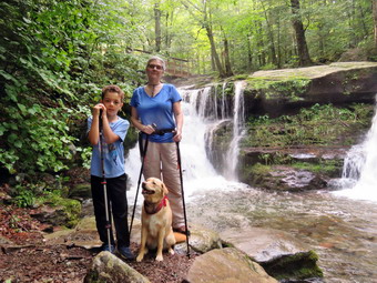
![]() On Wednesday, August 15th we finished visiting and taking pictures at Halcott Falls on Route 42 and headed north to Spruceton. I turned right on Spruceton Road and drove all the way to the end. There were some DEC crews replacing the signs at the two parking areas. I drove to the snowplow turnaround and parked there. Even though this is a "No Parking Area", the unwritten agreement is that parking is allowed when there is no possibility there will be any snowplows turning around. There were no cars parked in this area and only pen or two in the other lots. The temperature was 80 degrees when we all got out of the car. Sheila was happy to be finally released and ran around sniffing everything. I set my GPS out of habit and we started up the trail at 10:15 AM. The trail was very wet with both standing and running water and mud in many places. Cindy and I both had on hiking boots but Bryce only had sneakers. He is growing so fast it is hard to keep him in appropriate footwear. The stream was high but the water was crystal clear where it wasn't white from rolling over the rocks. There were several places where I thought about taking pictures but decided to wait for the return trip. The trail is slightly uphill and a little longer than I remembered but after a little less than a mile we were at the falls. We could see from the trail that there was a good volume of water going overt he falls. We all worked our way down the steep and eroded path to the base of the falls.
On Wednesday, August 15th we finished visiting and taking pictures at Halcott Falls on Route 42 and headed north to Spruceton. I turned right on Spruceton Road and drove all the way to the end. There were some DEC crews replacing the signs at the two parking areas. I drove to the snowplow turnaround and parked there. Even though this is a "No Parking Area", the unwritten agreement is that parking is allowed when there is no possibility there will be any snowplows turning around. There were no cars parked in this area and only pen or two in the other lots. The temperature was 80 degrees when we all got out of the car. Sheila was happy to be finally released and ran around sniffing everything. I set my GPS out of habit and we started up the trail at 10:15 AM. The trail was very wet with both standing and running water and mud in many places. Cindy and I both had on hiking boots but Bryce only had sneakers. He is growing so fast it is hard to keep him in appropriate footwear. The stream was high but the water was crystal clear where it wasn't white from rolling over the rocks. There were several places where I thought about taking pictures but decided to wait for the return trip. The trail is slightly uphill and a little longer than I remembered but after a little less than a mile we were at the falls. We could see from the trail that there was a good volume of water going overt he falls. We all worked our way down the steep and eroded path to the base of the falls.
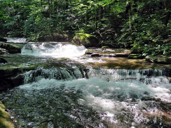 Once at the base of the falls, I got out my camera to take pictures. I ran into a problem that would plague me all day. The great volume of water created a spray and a slight breeze was blowing the spray toward me and it was titling on the camera lens. I cleaned off the else and began to develop a technique of quickly taking a picture in between the gusts. I took pictures of both falls and tried to include the bridge above. I took a few shots downstream and tried several different setting on the camera. The last pictures I took were of Bryce, Cindy and Sheila with then falls in the background. We worked our way back up the bank and walked toward the bridge. I took some more shots of the falls from above and some of the bridge. I also took pictures from the bridge across the top of the falls and upstream. I walked off the end of the bridge and took some more shots of the top if the falls. Cindy and I looked at the sign and were puzzled. The sign indicated that the Buck Ridge lookouts were farther away than the summit of Westkill Mountain. This, of course, is incorrect and the DEC should be embarrassed to post these incorrect signs! Once we were finished at the falls, we headed back down the trail to the car. I stopped twice and worked my way down the slippery rocks to the streambed to take pictures. The sun was upstream but still rather low and there was a haze hanging over the stream. I hoped that some of the shots I took would capture this. The walk back down the trail seemed to go quickly despite the water on the trail and we were soon back at the car. It was 11:15 AM when we got back in the car and headed back out the Spruceton Road. At the end I turned right on Route 42 to head toward Lexington and Route 23A. Our next stop would be Kaaterskill Falls.
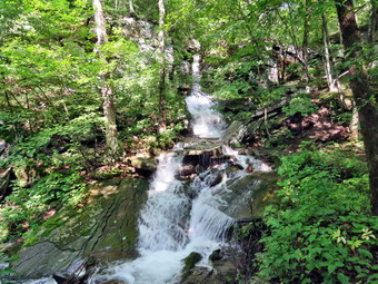
![]() On Wednesday, August 15th I was ready to get out after 4 days of rain had made getting out to hike almost impossible. Since my grandson Bryce was available, I thought about hiking Hunter from Spruce since I knew that even though that trail would be wet it would be relatively safe both on the ascent and descent. I asked Cindy about doing the hike which we have done before but she declined. I began to think about all the rain that had fallen and decided to take advantage of it and visit as many waterfalls as we could. Cindy liked this idea and when Bruce arrived at our house at 7:45 AM he was enthusiastic about the plan. The skies were blue in spots but there were still a lot of clouds. We began to get ready to leave at about 8:30 AM which is when Sheila began to watch my every move. I got dressed in a short-sleeved crew top with a short-sleeved baselayer. I put on a pair of RailRiders hiking pants which are expensive but last along time and have features like deep pockets and a generous cut which I really like. The pants have Velcro closures at the ankles which I hoped would mean I could fend off the ticks which have been very numerous so far this season. I put on my Vasque Taku hiking boots which fit nicely and are now discontinued. We got our gear in the car and got Sheila and Bryce in the backseat. I had wanted to leave as early as possible but we didn't leave Livingston Manor until around 9:00 AM with the temperature in the upper 70's. I drove out DeBruce Road all the way to the end and the turned left onto Route 47. We immediately ran into the road crews who were trying to restore the right lane of the road which had been washed away by the high waters of the Neversink River. The wait wasn't long and we were soon passing by the FrosTvalley YMCA. I continued on Rt 47 passing the trailheads at Biscuit Brook, Slide Mountain and Giant Ledge/Panther. There were a few cars at each spot but they didn't look very crowded. At Route 28 I turned right and drove a few miles before turning left and heading north on Route 42 toward Lexington. There was another road crew doing some patching but we went passed them quickly.
On Wednesday, August 15th I was ready to get out after 4 days of rain had made getting out to hike almost impossible. Since my grandson Bryce was available, I thought about hiking Hunter from Spruce since I knew that even though that trail would be wet it would be relatively safe both on the ascent and descent. I asked Cindy about doing the hike which we have done before but she declined. I began to think about all the rain that had fallen and decided to take advantage of it and visit as many waterfalls as we could. Cindy liked this idea and when Bruce arrived at our house at 7:45 AM he was enthusiastic about the plan. The skies were blue in spots but there were still a lot of clouds. We began to get ready to leave at about 8:30 AM which is when Sheila began to watch my every move. I got dressed in a short-sleeved crew top with a short-sleeved baselayer. I put on a pair of RailRiders hiking pants which are expensive but last along time and have features like deep pockets and a generous cut which I really like. The pants have Velcro closures at the ankles which I hoped would mean I could fend off the ticks which have been very numerous so far this season. I put on my Vasque Taku hiking boots which fit nicely and are now discontinued. We got our gear in the car and got Sheila and Bryce in the backseat. I had wanted to leave as early as possible but we didn't leave Livingston Manor until around 9:00 AM with the temperature in the upper 70's. I drove out DeBruce Road all the way to the end and the turned left onto Route 47. We immediately ran into the road crews who were trying to restore the right lane of the road which had been washed away by the high waters of the Neversink River. The wait wasn't long and we were soon passing by the FrosTvalley YMCA. I continued on Rt 47 passing the trailheads at Biscuit Brook, Slide Mountain and Giant Ledge/Panther. There were a few cars at each spot but they didn't look very crowded. At Route 28 I turned right and drove a few miles before turning left and heading north on Route 42 toward Lexington. There was another road crew doing some patching but we went passed them quickly.
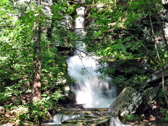 Near the top of the hill in the notch, I pulled over and parked at the trailhead for Halcott and Sleeping Lion. Both are bushwhacks and on the Catskill Highest Hundred list with Halcott being a Catskill 3500 peak. We would not be climbing the mountains today but just looking at the waterfall which is within 100 feet of the parking area! Bryce and I got out of the car and I grabbed my Camera to walk over to the waterfall. There was a good volume going over the falls which ideally only a trickle. I took several shots from different angles. I explained to Bruce that I had bushwhacked parallel to the road several times in wet conditions and found several different waterfalls. Some of these only exist after heavy rains and dry up afterwards. I also explain to him the route up the side of the water fall and to Sleeping Lion and then Halcott. He is always very interested and asks a lot of questions. I answer them as best I can. We walked back to the car where I stowed my camera. I continued north on Route 42 toward Spruceton.
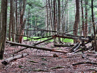
![]()
![]()
![]()
![]()
![]() On Friday, August 10th I was ready to do a longer hike with son-in-law Brad after two days of rain had kept us inside and off the trails. Brad and I had done a late night ambulance call so we both slept in later than we normally would. The forecast for the day included some late day thunderstorms but the chance of rain up to 5:00 PM was near 0%. I decided that we would go to Ashokan High Point and when I checked my records I found I had not been there in three years! I thought that this was one of the lookouts that was to be "cut out" to restore the view that had diminished over time as the trees had grown up. When I got up at 9:30 AM the temperature on the back porch registered 94 degrees but I expected that was because it was in direct sunlight! The skies were blue in spots but there were a lot of clouds gathering especially to the north and west. We began to get ready to leave at about 10:30 AM which is when Sheila began to watch my every move. I got dressed in a short-sleeved crew top with a short-sleeved baselayer. I put on a pair of RailRiders hiking pants which are expensive but last along time and have features like deep pockets and a generous cut which I really like. The pants have Velcro closures at the ankles which I hoped would mean I could fend off the ticks which have been very numerous so far this season. I put on my Vasque Taku hiking boots which fit nicely and are now discontinued. Brad and I got our gear in the car and Sheila in the backseat. At 11:00 AM we pulled out of Livingston Manor and headed to Liberty on Route 17. I took Route 55 toward Grahamsville passing over the Neversink dam where water was still going over the spillway. Just after the TriValley schools, I turned left on Route 55A and continued straight ahead on the Sundown Road. I continued on this road through Sundown and passed the Peekamoose parking area. There were a few cars parked there but I suspected more people were going to the Blue Hole to swim than were hiking the mountains. The Blue Hole has become so popular and overused that the DEC is now requiring free permits on weekends and holidays. The drive to the trailhead parking was longer than I remembered and there was a long descent which I had forgotten. I pulled into the Ashokan High Point parking area at about 11:45 AM and found several cars parked there. It also looked like there was some construction going on near the trail on the other side but I assumed we could get through to hike. The skies were a little dark but there were some blue spots and Brad and I decided we would try the hike as long as we had traveled so far. We got our gear ready and I set both my Garmin 64st handheld unit and my Suunto Traverse watch. I put Sheila on her leash and we quickly crossed the road to begin our hike. The temperature was 73 degrees but the humidity seemed high and the bugs were swarming. It was hard to determine what the construction workers were doing but there were many large blacks of rock and several machines present. There was a fence to prevent people from entering the construction area but it allowed us access to the trail. We crossed Kanape Brook on the bridge and started up the trail. The trail is rocky and on this day it was very wet which made all the rocks slippery. There was some standing water and some running water on the trail but we set a good pace on the flatter parts. The trail parallels Kanape Brook and we could hear the water as it cascaded over the rocks. There was water in the stream but I had expected it to be much higher than it was. We crossed several small streams and eventually a larger one that required a small foot bridge.
On Friday, August 10th I was ready to do a longer hike with son-in-law Brad after two days of rain had kept us inside and off the trails. Brad and I had done a late night ambulance call so we both slept in later than we normally would. The forecast for the day included some late day thunderstorms but the chance of rain up to 5:00 PM was near 0%. I decided that we would go to Ashokan High Point and when I checked my records I found I had not been there in three years! I thought that this was one of the lookouts that was to be "cut out" to restore the view that had diminished over time as the trees had grown up. When I got up at 9:30 AM the temperature on the back porch registered 94 degrees but I expected that was because it was in direct sunlight! The skies were blue in spots but there were a lot of clouds gathering especially to the north and west. We began to get ready to leave at about 10:30 AM which is when Sheila began to watch my every move. I got dressed in a short-sleeved crew top with a short-sleeved baselayer. I put on a pair of RailRiders hiking pants which are expensive but last along time and have features like deep pockets and a generous cut which I really like. The pants have Velcro closures at the ankles which I hoped would mean I could fend off the ticks which have been very numerous so far this season. I put on my Vasque Taku hiking boots which fit nicely and are now discontinued. Brad and I got our gear in the car and Sheila in the backseat. At 11:00 AM we pulled out of Livingston Manor and headed to Liberty on Route 17. I took Route 55 toward Grahamsville passing over the Neversink dam where water was still going over the spillway. Just after the TriValley schools, I turned left on Route 55A and continued straight ahead on the Sundown Road. I continued on this road through Sundown and passed the Peekamoose parking area. There were a few cars parked there but I suspected more people were going to the Blue Hole to swim than were hiking the mountains. The Blue Hole has become so popular and overused that the DEC is now requiring free permits on weekends and holidays. The drive to the trailhead parking was longer than I remembered and there was a long descent which I had forgotten. I pulled into the Ashokan High Point parking area at about 11:45 AM and found several cars parked there. It also looked like there was some construction going on near the trail on the other side but I assumed we could get through to hike. The skies were a little dark but there were some blue spots and Brad and I decided we would try the hike as long as we had traveled so far. We got our gear ready and I set both my Garmin 64st handheld unit and my Suunto Traverse watch. I put Sheila on her leash and we quickly crossed the road to begin our hike. The temperature was 73 degrees but the humidity seemed high and the bugs were swarming. It was hard to determine what the construction workers were doing but there were many large blacks of rock and several machines present. There was a fence to prevent people from entering the construction area but it allowed us access to the trail. We crossed Kanape Brook on the bridge and started up the trail. The trail is rocky and on this day it was very wet which made all the rocks slippery. There was some standing water and some running water on the trail but we set a good pace on the flatter parts. The trail parallels Kanape Brook and we could hear the water as it cascaded over the rocks. There was water in the stream but I had expected it to be much higher than it was. We crossed several small streams and eventually a larger one that required a small foot bridge.
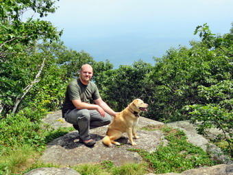 I was surprised that the trail was so poorly maintained with many old blowdowns and several new ones. Some were relatively easy to step over but others block the trail and required a detour. This is becoming a real problem even on some of the more popular trails in the Catskills. Several times we could hear rain falling on the trees but the drops never seemed to get through to us. At 1.5 miles the trail flattened a little and then started a somewhat steeper climb. We crossed another small bridge and entered a tunnel of pine trees. The ground was covered with small twigs broken from the trees and these formed a sort of carpet on the ground. From this point on the trail became much rockier as more water flowed on the trail eroding the soil between the stones. This trail is marked on some maps as the Kanape Jeep Trail. Along the way we met one solo hiker who had been hiking on Mombaccus Mountain. At 2.7 miles we reached the turn to the left where the trail begins the 1 mile climb to the High Point. It was 1:15 PM and I began to weigh our options once we reached the top. I remembered that the trail to the High Point was rocky and steep in places and that there were several places where there were steep climbs followed by more level spots. Some of the these climbs even had a series of stone steps. We came to a wide spot in the trail and stopped to get a drink and a bar. This improved my mood a little but I was still a little tired and beaten down by the humidity. A little farther up the trail, there were some switchbacks and then a small path went off to the right. I remembered following this path before and not finding any real views so we skipped it this time. We continued climbing toward the top with me questioning my fitness level! The overall grade averages about 17% with some flatter and some steeper areas. There are no real views along the way until near the very top. There are five different short climbs several of which have stone steps. At one point there is a rock overhang which forms a small shelter. I had passed this many times but this time I noticed I tree seemingly growing out of the very top of the rock. I made a note to stop on the way back to take a few pictures. By this time I had decided we would do an out and back hike since the loop adds over a mile and has few attractions. As we climbed the last ascent I remembered there used to be some nice views of Mombacus and Little Rocky from a rock outcrop on the trail. The skies were hazy and the view was now mostly blocked by the trees.
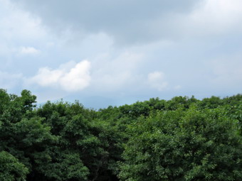 We finished the climb to the High point and found no one else there. I was VERY disappointed that the lookout had NOT been improved and that the trees had all but obscured the view of anything. I took a few pictures from the High Point but the views were too hazy to be really nice. I did take a shot of Brad and Sheila. We got a drink and found the USGS seal and the anchor points for a tower which had been removed a long time ago. I though about going to Little Ashokan High Point but decided that would have to be another day. Before turning around to head back, I decided we should walk a little farther along the trail to see if any of the other views remained. We walked over to the next lookout in the opposite direction but the views were much the same with trees blocking the view. We continued along the trail heading for an open field with a fire ring that always had good views. There are several small depressions along the way that collect water. They appear to be manmade but no one has been able to tell me anything about them. When we got to the open field, I was VERY disappointed that the views her were also blocked by the trees. Some mountains were just barely visible above the tree tops but they were covered in haze! I dropped my pack and took out the camera to try to take some shots of the Burroughs Range. I now knew that this was not a hike I would recommend to people unless they found their way to Little Ashokan High Point as the views are nonexistent! We turned around and returned on the trail to the High Point and began the descent back to the trail junction. I was worried that it would be a difficult descent but it went rather quickly. We did have to be careful as there were some slippery rocks and spots where it was easy to slip on the gravel. I did stop to take some pictures of the rock with the tree on it. We reached the trail junction in about the same time it had taken to do the ascent! Once we made the turn we quickened our pace on the downhill spurred on by the showers that kept appearing and disappearing. On the way back we concentrated on speed and were soon nearing the end of the trail as the showers became more persistent. We walked across the bridge and I stopped to take a few shots of the stream, the bridge and the construction project. We were back at the car at 4:25 PM having spent 4.5 hours hiking 7.8 miles and we had spent almost 5 hours hiking the 9.1 mile loop with about 30 minutes of stopped time. The vertical gain was 2130 feet. I had hiked Slide Mountain with Bryce on Monday and the vertical gain was only 1750 feet! The temperature at the car was 77 degrees and the rain was falling rather heavily.
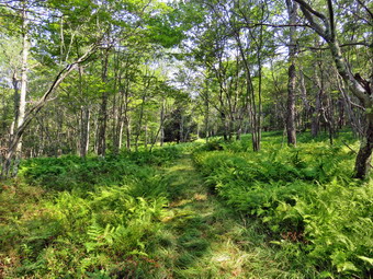
![]()
![]()
![]()
![]()
![]() On Tuesday, August 7th I had planned to go hiking somewhere close to home as I had hiked Slide Mountain the day before with my grandson Bryce. I decided I would hike a loop on the east side of Mongaup Pond. This was a loop that Cindy and I had started a few weeks ago but aborted. The temperature was in the high 70's at 9:00 AM when I started to get ready and the forecast called for it to get even warmer and more humid later in the day. There was also a chance of thunderstorms later in the day. Sheila was happy as I got my gear together and stayed close to me to make sure I knew she wanted to go. I got dressed in a short-sleeved crew top with a short-sleeved baselayer. I put on a pair of RailRiders hiking pants which are expensive but last along time and have features like deep pockets and a generous cut which I really like. The pants have Velcro closures at the ankles which I hoped would mean I could fend off the ticks which have been very numerous so far this season. I put on my Vasque Taku hiking boots which fit nicely and are now discontinued. I got my gear in the car and Sheila in the backseat. I started out the DeBruce Road at 9:15 AM and turned left after six miles on Mongaup Pond Road. As I drove up the road, I could see the sky was blue with white puffy clouds. At the split in the road I stayed to the right on Mongaup Pond Road and pulled into the small parking area on the right side of the road. There were no other cars in the lot and none parked at Mongaup Falls. The temperature on the car read 77 degrees and as I got out of the car I could feel the humidity hit me like a wall. I got my GPS set and then let a frantic Sheila out of the car so that we could begin our hike at 9:40 AM. I put Sheila on her leash and we walked back toward the intersection to turn left to hike down what used to be Hunter Road. I let Sheila off her leash and we walked across the small bridge over the stream. We continued up the rocky hill toward the snowmobile trails that make up most of this hiking loop.
On Tuesday, August 7th I had planned to go hiking somewhere close to home as I had hiked Slide Mountain the day before with my grandson Bryce. I decided I would hike a loop on the east side of Mongaup Pond. This was a loop that Cindy and I had started a few weeks ago but aborted. The temperature was in the high 70's at 9:00 AM when I started to get ready and the forecast called for it to get even warmer and more humid later in the day. There was also a chance of thunderstorms later in the day. Sheila was happy as I got my gear together and stayed close to me to make sure I knew she wanted to go. I got dressed in a short-sleeved crew top with a short-sleeved baselayer. I put on a pair of RailRiders hiking pants which are expensive but last along time and have features like deep pockets and a generous cut which I really like. The pants have Velcro closures at the ankles which I hoped would mean I could fend off the ticks which have been very numerous so far this season. I put on my Vasque Taku hiking boots which fit nicely and are now discontinued. I got my gear in the car and Sheila in the backseat. I started out the DeBruce Road at 9:15 AM and turned left after six miles on Mongaup Pond Road. As I drove up the road, I could see the sky was blue with white puffy clouds. At the split in the road I stayed to the right on Mongaup Pond Road and pulled into the small parking area on the right side of the road. There were no other cars in the lot and none parked at Mongaup Falls. The temperature on the car read 77 degrees and as I got out of the car I could feel the humidity hit me like a wall. I got my GPS set and then let a frantic Sheila out of the car so that we could begin our hike at 9:40 AM. I put Sheila on her leash and we walked back toward the intersection to turn left to hike down what used to be Hunter Road. I let Sheila off her leash and we walked across the small bridge over the stream. We continued up the rocky hill toward the snowmobile trails that make up most of this hiking loop.
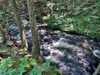 At .4 miles we passed by a snowmobile trail that we could use on the return trip. I knew this trail would be very wet and thought we might use the roads to walk back. After a short descent, we again began to climb on the rocky and rather wet woods road toward Terwilliger Road. At 1 mile we turned left as the snowmobile trail turned into the woods. Here the trail was drier with some muddy spots along the way but the surface was flat which made walking go very quickly. I stopped in an open glade covered in ferns and I took some pictures before moving on. A little farther along a bridge crossed a small stream and I again stopped to take a few shots. The trail dropped a little as we headed northeast and then at 1.4 miles we began to climb again. At 2.35 miles we were still climbing as the trail headed southeast to reach the highest point on the trail at 2.7 miles. From here the trail began to descend and at 2.9 miles the trail again turned northeast and continued dropping in elevation. The trail had been wet and muddy in places. All the rocks were covered in water from the condensed humidity in the air making them very slippery. At 3.8 miles we reached the Mongaup Willowemoc Trail where we turned left and started heading northwest. We started climbing again over some very rocky terrain until we reached the top of a hill at 4.5 miles and started to descend the other side. There had been several blowdown along the trails which were just the size to remove with hand tools. I don't know who is responsible for these trails but I do know it would be fun to remove these obstacles. It was getting much warmer and more humid so I stopped several times to get a drink. The trail was wet and muddy and showed evidence that there had been a lot of water flowing over them. We continued our descent until at 5.2 miles the Mongaup Willowemoc Trail ended at a snowmobile trail. I knew that turning left on the snowmobile trail would be a wet experience. The trail is often very wet as it is lower than the land to the east and water draining from the higher land floods the trail. I decided we would walk straight ahead at this junction to access the roads at Mongaup State Campgrounds. This trail was VERY wet and muddy where a small stream spread out across the land. At 5.9 miles we walked across an empty campsite and out onto the campground roads. I put Sheila on her leash as we turned right and walked out to the loop road where we turned right again. We walked out to the entrance of the park and continued out to Mongaup Pond Road at 6.2 miles. As we walked along the road, the outlet stream ran parallel to us. As it came closer to the road, I decided to stop and take a few pictures. I took my shots and then we continued on the road to walk back to the car. We arrived at the car at 12:45 PM after having hiked 7.3 miles in 3 hours and 5 minutes with an elevation gain of 1095 feet. I considered walking down to Mongaup Falls to take some pictures but in the end I just in the car. The temperature was 82 degrees and it was still humid.
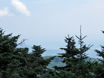
![]()
![]()
![]()
![]()
![]() On Monday, August 6th, I decided I wanted to hike Slide Mountain as I had not been there is a year and it is close to home. I like to throw in a 3500 foot peak every now and then for the challenge and to prove to myself I can still hike elevation as well as distance. The night before I made arrangements for my grandson Bryce to hike with me. I knew Bryce wouldn't arrive until after 9:00 AM and that the temperatures were expected to rise into the high 80's by noon but I was willing to wait as hiking with Bryce is so interesting. The start of the day was very foggy but Bryce and I were aiming to get out as quickly as possible. Bryce arrived and as I started to get ready Sheila was very excited and indicated she didn't care where we went as long as we got out of the house. I got dressed in a short-sleeved crew top with a short-sleeved baselayer. I put on a pair of RailRiders hiking pants which are expensive but last along time and have features like deep pockets and a generous cut which I really like. The pants have Velcro closures at the ankles which I hoped would mean I could fend off the ticks which have been very numerous so far this season. I put a pair of keen Glarus boots which fit nicely and have been discontinued! I headed out the DeBruce Road at about 10:00 AM and drove passed Round Pond and down to Route 47. I turned left and drove toward Frost Valley. Almost immediately we ran into a stop light on the road. Construction crews were working to repair the road where the Neversink River had washed away a lane of the road. The wait wasn't long and after waiting at another construction project I drove by the Frost Valley YMCA camp. The Biscuit Brook parking area had only one car in it and I wondered if Slide would be crowded. I pulled in just before 10:30 AM and found a half dozen cars in the lot. Another car pulled in just as we were getting ready to leave. I set my Garmin GPS unit and we got on the trail right away. Starting out on the main trail we immediately came to the Neversink River which had a good volume of water flowing in it. Bryce was wearing low sneakers so we looked round for a way to get him across without getting wet. He saw a large tree down across the river and Bryce decided to use it to cross. I assumed he would sit on the trunk and shimmy across it so I looked for a route to get myself across. I used stepping stones to get across to a middle ground and the looked over to see how Bryce was doing. Bryce was on all fours nimbly crawling across the trunk! I wanted to take some pictures but decided I could OD that on the way back. I worked my way across to the other side of the river. The trail was damp and muddy in many places but initially there was no water on the trail. We crossed two more small streams and were soon climbing through a very rocky area. In just less than half a mile we had worked our way through the rocky ascent and turned right on the woods road.
On Monday, August 6th, I decided I wanted to hike Slide Mountain as I had not been there is a year and it is close to home. I like to throw in a 3500 foot peak every now and then for the challenge and to prove to myself I can still hike elevation as well as distance. The night before I made arrangements for my grandson Bryce to hike with me. I knew Bryce wouldn't arrive until after 9:00 AM and that the temperatures were expected to rise into the high 80's by noon but I was willing to wait as hiking with Bryce is so interesting. The start of the day was very foggy but Bryce and I were aiming to get out as quickly as possible. Bryce arrived and as I started to get ready Sheila was very excited and indicated she didn't care where we went as long as we got out of the house. I got dressed in a short-sleeved crew top with a short-sleeved baselayer. I put on a pair of RailRiders hiking pants which are expensive but last along time and have features like deep pockets and a generous cut which I really like. The pants have Velcro closures at the ankles which I hoped would mean I could fend off the ticks which have been very numerous so far this season. I put a pair of keen Glarus boots which fit nicely and have been discontinued! I headed out the DeBruce Road at about 10:00 AM and drove passed Round Pond and down to Route 47. I turned left and drove toward Frost Valley. Almost immediately we ran into a stop light on the road. Construction crews were working to repair the road where the Neversink River had washed away a lane of the road. The wait wasn't long and after waiting at another construction project I drove by the Frost Valley YMCA camp. The Biscuit Brook parking area had only one car in it and I wondered if Slide would be crowded. I pulled in just before 10:30 AM and found a half dozen cars in the lot. Another car pulled in just as we were getting ready to leave. I set my Garmin GPS unit and we got on the trail right away. Starting out on the main trail we immediately came to the Neversink River which had a good volume of water flowing in it. Bryce was wearing low sneakers so we looked round for a way to get him across without getting wet. He saw a large tree down across the river and Bryce decided to use it to cross. I assumed he would sit on the trunk and shimmy across it so I looked for a route to get myself across. I used stepping stones to get across to a middle ground and the looked over to see how Bryce was doing. Bryce was on all fours nimbly crawling across the trunk! I wanted to take some pictures but decided I could OD that on the way back. I worked my way across to the other side of the river. The trail was damp and muddy in many places but initially there was no water on the trail. We crossed two more small streams and were soon climbing through a very rocky area. In just less than half a mile we had worked our way through the rocky ascent and turned right on the woods road.
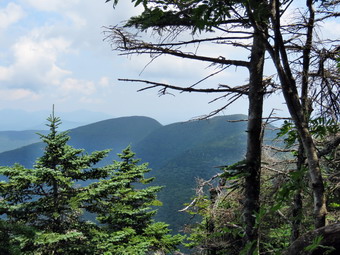 Almost immediately the trail became wet with standing and running water. At .7 miles we turned left and started up the main trail to Slide Mountain which, according to the sign, was 2 miles away. The trailhead for Slide has a relatively high elevation so, although it is the highest peak in the Catskills, the elevation gain and grade are relatively modest. The temperature seemed high as did the humidity and I was feeling a little down which was not helped by watching Bryce easily bound up the trail. We continued up the trail working around the wet areas. We passed by the designated campsite to the right of the trail and as we started up the steeper climb Sheila alerted. The hiker who had pulled into the parking area after us was catching up. He was setting a fast pace and we said "hello" as he passed us. I was feeling a little tired and very warm and sweaty. We stopped for a drink and then continued up the trail. The trail was every bit as rocky as it ever was which makes ascending difficult and descending worse. Bryce was still setting a good pace and I was slowing him down! I kept looking for the 3500 foot sign but did not see it. Soon we started to enter the transition zone from hardwoods to evergreens and I knew we were passed 3500 feet. Bryce and I both noticed that we could smell the strong odor of balsam fir and we also noticed that the temperature had dropped noticeably. At 1.7 miles the trail started to level some as the grade became more shallow and all these factors combined to raise my spirits. Bryce pointed out the sand on the trail and we talked about why it was there. The glimpses I could get of the sky showed bright blue with white clouds and plenty of sun. We continued up the trail and I began to notice that some of the blowdowns had been cleared from the trail by chainsaw. I assumed that a DEC crew had been assigned to clear the trail after the heavy storm in May. There were still quiet a few trees leaning over the trail which I do not think is a good situation. Some trees were low and had branches cut in such a way that the remaining pieces formed "spears" that pointed downward. I imagine some taller hikers may have had problems with these. There were several lookouts along the way but most were not interesting and what I could see was very hazy. There were one or two that did have possibilities but I decided to wait until the return trip to take any pictures. Somewhere along the way a young man came up behind us running up the trail! He quickly passed us and disappeared. Soon the trail leveled again as we had done most of the climbing. At 2 miles we passed the Curtis-Ormsbee Trail as it came in from the left from the Denning trailhead. The trail leveled some here and Bryce and I enjoyed walking along the path strewn with pine needles. The trail continued to be muddy which was unusual this high up on Slide. Soon we were approaching the last climb and I found a viewpoint that clearly showed Cornell and Wittenberg and the col between them. At 2.6 miles we were at the viewpoint toward Panther and Giant Ledge. I decided to stop and take a look and found the trees in front of the lookout had all but obscured the view.
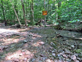 We returned to the main trail and soon were passing by the highest point on Slide. Cement blocks mark the location where a fire tower once stood. We continued to the rock outcropping to find theater who had passed us, another male hiker and about 20 young women. It was 12:25 PM and we had covered 2.7 miles. Bryce sat down to eat his lunch as I got put the camera to take some pictures. I tried to take a few pictures of the Ashokan Reservoir, Cornell and Wittenberg and found the views were mostly blocked by the trees. There was a haze hanging over the far peaks but I still took a few pictures. I had considered going down the other side to the spring but wanted to make sure Bryce and I were fresh to walk back down the mountain. I got a drink and ate a bar to prepare for the return trip. I found out that the girls were from a Jewish camp. On Sunday they had hiked from Woodland Valley over Wittenberg and Cornell and camped in the designated camping area in the Col. On Monday they had hiked up Slide and were now heading for Denning on The Curtis-Ormsbee Trail. Their plan was to camp somewhere along the Neversink on Monday night and then hike over Table and Peekamoose on Tuesday. We said "Goodbye" and headed back done the mountain at 12:40 PM. We stopped at the first viewpoint on the right and I took a few pictures. The views of Giant Ledge and Panther were blocked but I got some pictures of Cornell and Wittenberg despite the haze. We stopped again at a lower lookout and I took a few more shots before we got back to the trail. I had hoped to make quick work of the descent but the rocks make the descent difficult to accomplish safely. The hiker who had pulled in just after us passed us on his way down. Soon a few of the girls from the group that had been at the summit caught up to us. I spoke to one about their plans and told them about the Avenza app. As we hiked own we met several groups of people headed up the mountain. Some seemed well-equipped but others were carrying a single small bottle of water. I always hike with poles even when it seems I don't need them. On this hike I was very glad I had them with me. Sheila was staying with us for the most part and alerting every time she saw someone coming toward us. We passed the 3500 foot level and continued down the trail. On the ascent I thought there seemed to be less rolling rocks than I remembered but they were all there on the descent. The water was more bothersome on the way down sine it made all the rocks slippery and we both knew that slipping on the Wat down was worse than on the ascent. We stopped to get a drink and then made the push to get back to the trail junction. When we arrived at the junction, we turned right on the woods road and hiked along the wet and muddy trail that leads back to the parking area. We turned left and started to descend through the very rocky area but we made good time back to the river bed. I stopped to take a few pictures of the water in the river. I asked Bryce to again cross on the log while I took a video. He made the crossing slipping in one spot but recovering nicely to make it to the other side. We crossed the last small bit of water and walked back to the car. There were fewer cars now in the parking area. We arrived at the car at 2:40 PM having covered 5.5 miles in 4 hours and 10 minutes with 1794 feet of elevation gain. Bryce was fresh and never complained about the hike!
![]()
![]()
![]()
![]()
![]() On Saturday, August 4th I wanted to get in a hike where there was a waterfall that might have been augmented by the recent rain. I had hiked the day before on Round Top but had to cut it short as a thunderstorm rolled in. I asked Cindy if she wanted to go hiking in the Trout Pond area and she agreed. The forecast was calling for some morning showers so we decided to wait until noon to leave even though we knew the temperature and humidity would be higher at that time. We also knew that the trails in the Trout Pond area would probably be very wet due to the recent rains in the area. The showers never did materialize and as we began to get ready to leave home the temperature was already in the high 70's with high humidity. As I started to get ready, Sheila was frenzied. She gets especially excited when both Cindy and I go on the hike. I got dressed in a short-sleeved crew top with a short-sleeved baselayer. I put on a pair of RailRiders hiking pants which are expensive but last along time and have features like deep pockets and a generous cut which I really like. The pants have Velcro closures at the ankles which I hoped would mean I could fend off the ticks which have been very numerous so far this season. I put a pair of Vasque Taku boots which fit nicely and have been discontinued! Sheila was ready to go and stayed close so that I would not forget her. Cindy and I put our packs in the trunk and Sheila in the backseat and headed for Roscoe on the Quickway a little after noon. I drove out the Rockland Flats on Route 206. Just after the Roscoe Nursing Home I turned left on Morton Hill Road and followed it for 3 miles to the intersection with Russell Brook Road. I turned around and parked on the side of the road avoiding the private parking area. When I opened the car door, I was hit my a blast of hot and humid air. I checked the car thermometer and found that it was only 80 degrees with the hint of a breeze. I set the my Garmin GPS unit and my Suunto Traverse GPS watch and started down Russell Brook Road. The road was wet in several places. I listened for the sound of the water in the brook and heard a good amount of noise. There were no cars parked at the campsites along the road which surprised me a little. When we came to the viewpoint over the upper falls, I could see there was a large volume of water going over the falls so I headed down the bank to a viewpoint. The steep path was slippery and I had to watch my step. I put down my pack and got out the camera. I took some shots of the falls with different settings. The sunlight was shining directly on the water making photography difficult. I took a few shots of the water passing through the narrow channel to the lower falls before packing up and climbing back up to the road. We walked down the road to the lower parking area and found it nearly full of cars. One or two people were at their car and seemed to be getting ready to leave. We continued down the road and just before we crossed the bridge over Russell Brook there was a fisherman in the brook. As we crossed the bridge we met three people heading toward us. We greeted each other and one of the others told us it was a fine day for a hike. We found that the Japanese knotweed that I had cut down had managed to grow back and had started to encroach on the trail once more. We continued on the road turning right on the path to the falls walking between the tall grass and the knotweed. We walked over to the path down the bank to the streambed and carefully descended to the brook. The falls were flowing with a volume almost as great as during the spring rains. The breeze blowing toward us from the falls was bringing the spray with it and wetting down all the rocks and roots. I got out my camera and took some pictures of the falls and then some of the stream. I took a few more pictures of the falls before putting away the camera and walking back out to the main trail.
On Saturday, August 4th I wanted to get in a hike where there was a waterfall that might have been augmented by the recent rain. I had hiked the day before on Round Top but had to cut it short as a thunderstorm rolled in. I asked Cindy if she wanted to go hiking in the Trout Pond area and she agreed. The forecast was calling for some morning showers so we decided to wait until noon to leave even though we knew the temperature and humidity would be higher at that time. We also knew that the trails in the Trout Pond area would probably be very wet due to the recent rains in the area. The showers never did materialize and as we began to get ready to leave home the temperature was already in the high 70's with high humidity. As I started to get ready, Sheila was frenzied. She gets especially excited when both Cindy and I go on the hike. I got dressed in a short-sleeved crew top with a short-sleeved baselayer. I put on a pair of RailRiders hiking pants which are expensive but last along time and have features like deep pockets and a generous cut which I really like. The pants have Velcro closures at the ankles which I hoped would mean I could fend off the ticks which have been very numerous so far this season. I put a pair of Vasque Taku boots which fit nicely and have been discontinued! Sheila was ready to go and stayed close so that I would not forget her. Cindy and I put our packs in the trunk and Sheila in the backseat and headed for Roscoe on the Quickway a little after noon. I drove out the Rockland Flats on Route 206. Just after the Roscoe Nursing Home I turned left on Morton Hill Road and followed it for 3 miles to the intersection with Russell Brook Road. I turned around and parked on the side of the road avoiding the private parking area. When I opened the car door, I was hit my a blast of hot and humid air. I checked the car thermometer and found that it was only 80 degrees with the hint of a breeze. I set the my Garmin GPS unit and my Suunto Traverse GPS watch and started down Russell Brook Road. The road was wet in several places. I listened for the sound of the water in the brook and heard a good amount of noise. There were no cars parked at the campsites along the road which surprised me a little. When we came to the viewpoint over the upper falls, I could see there was a large volume of water going over the falls so I headed down the bank to a viewpoint. The steep path was slippery and I had to watch my step. I put down my pack and got out the camera. I took some shots of the falls with different settings. The sunlight was shining directly on the water making photography difficult. I took a few shots of the water passing through the narrow channel to the lower falls before packing up and climbing back up to the road. We walked down the road to the lower parking area and found it nearly full of cars. One or two people were at their car and seemed to be getting ready to leave. We continued down the road and just before we crossed the bridge over Russell Brook there was a fisherman in the brook. As we crossed the bridge we met three people heading toward us. We greeted each other and one of the others told us it was a fine day for a hike. We found that the Japanese knotweed that I had cut down had managed to grow back and had started to encroach on the trail once more. We continued on the road turning right on the path to the falls walking between the tall grass and the knotweed. We walked over to the path down the bank to the streambed and carefully descended to the brook. The falls were flowing with a volume almost as great as during the spring rains. The breeze blowing toward us from the falls was bringing the spray with it and wetting down all the rocks and roots. I got out my camera and took some pictures of the falls and then some of the stream. I took a few more pictures of the falls before putting away the camera and walking back out to the main trail.
 At the trail junction just after the register we continued straight ahead to walk up to Trout Pond. The trail was damp in some spots and wet and muddy in others. Some small stream ran down the trail and others crossed it. When we arrived at the pond, we heard voices so I put Sheila on her leash as we turned left and walked out to the "beach" at the outlet end of the pond. The voices were coming from some people camping a the illegal campsite on the other side of the pond. The water level was high but not high enough for water to be flowing over the spillway. The skies were very blue with billowing white clouds so I knew I had to take some pictures. I took some panoramic pictures and then zoomed in on different parts of the scene. Sheila jumped into the water and began to swim around. I picked up a stick and threw it into the water for Sheila to retrieve. I did this several times and took some pictures each time. Each time Sheila came up out of the water she shook herself off usually next to one of us. After getting a drink and a snack, we packed up and headed back to the main trail. We continued on the main trail on the east side of Trout Pond walking toward the inlet end and the lean-tos. The trail was not as wet as I had expected with most of the water confined to the ruts on either side of a "hump" in the middle. No one was camping at the large campsite on the right side of the rail before the lean-tos. There was a large tent at the lower lean-to with several people present. As we crossed the bridge at the inlet end of the pond, I noticed that the inlet stream was very high. I stopped to take some pictures of the pond from the bridge and then continued on the trail. At this point the trail turns right and starts up a hill which is the shoulder of Cherry Ridge. At the turn the trail was covered in several inches of water from the overflow of the inlet stream and from a stream running down the trail. We stepped quickly through this area and started up the trail. The trail was acting as a very effective stream bed and we had to walk on the sides of the trail to stay out of the water. After some time, the running water abated only to start in a little farther along. At some places there was a stream to the right of the trail. These streams are normally running at only a trickle but they now had a large enough volume to have their own small falls! Walking was difficult as all the rocks were wet and everything was slippery. After we had walked for some time, I noticed a few large trees that had been cut with a chainsaw. I then remembered that there were places on the trail which previously had large blowdowns that were no longer present! I assumed a DEC crew had been sent through to clear the trail. Of course, since the crew had done there work there had been more storms and there were several smaller blowdowns across the trail. Soon we were at the highest point on Cherry Ridge and starting down the other side. I anticipated that the trail would have quite a bit of water but there was much more than I expected. There were areas where the trail was simply a stream that overflowed on either side making it difficult to find a dry place to walk. In other places there was standing water with pools over a foot deep. As we walked the trail, Sheila alerted and we saw a man walking toward us. As he approached, I saw he was wearing wading boots used for fishing and carrying a fly fishing pole. We greeted each other as we passed. I though afterwards that I should have taken a picture of a man carrying a fishing pole on a trail that looked like a stream!
 We continued on the trail picking our way around the wet areas which wasn't always easy. Soon we were at the woods road and snowmobile trail that runs by Mud Pond. I had considered walking down to Mud Pond but the walk on the wet trail was tiring. We turned left and start the short walk uphill. This part of the trail was also wet but we found places to walk including places on the trail that were wet but with only a shallow covering of water. At the top of the hill we began the long descent back to the trail junction where we had started. The descent lasts for .7 miles and drops 385 feet to a bridge that crosses the outlet stream from Trout Pond. This part of the trail was just as wet as the other sections. The water was spread across the trail in a shallow covering making for wet and muddy conditions. As we descended, we came to a spot where a small stream crosses. The stream is usually just a trickle and easy to cross but this time it was a small torrent. We decided to just cross even if it meant getting our feet a little wet. I was able to find one dry stepping stone and place my foot on another one with only a few inches of water. Once we crossed the stream I decided to take some pictures of the trail and the stream. I even was able to take some shots of some small waterfalls upstream from the trail! We continued down the hill on the main trail carefully picking our way. We crossed another small stream and walked toward the campsite at the bottom of the hill on the left side of the trail. There were several tents at the campsite with people relaxing. We said "Hello" and had short conversation about the trails. We continued on the trail crossing the bridge over a stream and walking back out to the trail register. We turned right adhered back toward the lower parking area on the main trail. As we approached the parking area, I noticed a large group of people at the kiosk so I put Sheila on her leash and waited for them to pass by us. As they passed, they asked questions about the water fall which we answered. We walked up the short path to the lower parking area. Every spot in the parking lot was taken and some cars were parked along the road! This was as full as I have ever seen this parking area. Sometimes the walk back up Russell Brook Road seems long and tedious but walking on a relatively dry and even surface made the hike go more quickly. We arrived back at the car at 3:45 PM after hiking 5.6 miles in 3 hours and 5 minutes with a 1130 foot total ascent. The temperature on the car thermometer was 84 degrees and the humidity was still high. After leaving the trailhead, we stopped by Northern Farmhouse Pasta to pick up some ravioli for dinner.
![]()
![]()
![]()
![]() On Friday, August 3rd I had not been out hiking for two days due to the rain showers and threat of rain showers. The forecast for Friday included showers and thunderstorms so I waited around the house all morning to see what would happen. The skies were cloudy but there was no rain. Around 11:30 AM I decided to take Sheila across the street to hike on Round Top thinking that if it did start to rain we could make it back home quickly. As I started to get ready, Sheila was frenzied. Her excitement seems to be in direct proportion to how long it has been since she has hiked. I asked Cindy if she wanted to go across the street but she declined. I got dressed in a short-sleeved crew top with a short-sleeved baselayer. I put on a pair of RailRiders hiking pants which are expensive but last along time and have features like deep pockets and a generous cut which I really like. The pants have Velcro closures at the ankles which I hoped would mean I could fend off the ticks which have been very numerous so far this season. I put a pair of Vasque Taku boots which fit nicely and have been discontinued! We crossed the street with Sheila on her leash and walked to the back of the church to begin the ascent of the steepest hill behind the church. The hill is short but really gets the circulation pumping and is the steepest and longest climb on the "trail". Sheila responds well to the command "Pull" and the Siberian husky in her makes her well-suited for the job. When we got to the top of the hill, we started out on the trail by turning left at the trailhead. I let Sheila off her leash and she bounded ahead of me following her nose. The trails were wet and muddy in spots. At the first trail junction I followed Sheila as she turned right and continued up the less steep part of the trail. Everything was very green but the humidity was high and I sweating almost immediately. We followed the blazes for the yellow trail up to the trail junction. We turned left at the trail junction and followed the yellow trail along the base of Round Top. At the next trail junction, we turned right on the blue trail and headed up the steepest hill to the summit of Round Top. On the summit we followed the trail over the top. We continued down the other side and I found a birch tree that had fallen across the trail. It was hung up in another tree but I was able to loosen it and get it down to the ground. I knew this would make it easier to cut it the next time I visited. At the yellow trail we turned right and then left at the next trail junction to head down to the lookout. At the lookout we turned left and descended the hill to the first trail junction. The skies were getting very dark and the wind was coming up nut I decided we could get in at least one more figure 8. We turned around and started back up the hill to the lookout. When we arrived at the top of the hill, thunder began to sound. I decided we should turn around and head home before the storm hit. We walked down the hill and continued out to the trailhead. At the trailhead I put Sheila on her leash and we turned right to descend the hill. We walked across the field to the driveway and home. The skies were even darker and the thunder claps more frequent. We made it home before it rained or any lightning strikes could be seen. We were home at 12:30 PM having spent 40 minutes walking a little more than a mile and doing some light trail maintenance. A few raindrops fell but most of the storm went around us!
On Friday, August 3rd I had not been out hiking for two days due to the rain showers and threat of rain showers. The forecast for Friday included showers and thunderstorms so I waited around the house all morning to see what would happen. The skies were cloudy but there was no rain. Around 11:30 AM I decided to take Sheila across the street to hike on Round Top thinking that if it did start to rain we could make it back home quickly. As I started to get ready, Sheila was frenzied. Her excitement seems to be in direct proportion to how long it has been since she has hiked. I asked Cindy if she wanted to go across the street but she declined. I got dressed in a short-sleeved crew top with a short-sleeved baselayer. I put on a pair of RailRiders hiking pants which are expensive but last along time and have features like deep pockets and a generous cut which I really like. The pants have Velcro closures at the ankles which I hoped would mean I could fend off the ticks which have been very numerous so far this season. I put a pair of Vasque Taku boots which fit nicely and have been discontinued! We crossed the street with Sheila on her leash and walked to the back of the church to begin the ascent of the steepest hill behind the church. The hill is short but really gets the circulation pumping and is the steepest and longest climb on the "trail". Sheila responds well to the command "Pull" and the Siberian husky in her makes her well-suited for the job. When we got to the top of the hill, we started out on the trail by turning left at the trailhead. I let Sheila off her leash and she bounded ahead of me following her nose. The trails were wet and muddy in spots. At the first trail junction I followed Sheila as she turned right and continued up the less steep part of the trail. Everything was very green but the humidity was high and I sweating almost immediately. We followed the blazes for the yellow trail up to the trail junction. We turned left at the trail junction and followed the yellow trail along the base of Round Top. At the next trail junction, we turned right on the blue trail and headed up the steepest hill to the summit of Round Top. On the summit we followed the trail over the top. We continued down the other side and I found a birch tree that had fallen across the trail. It was hung up in another tree but I was able to loosen it and get it down to the ground. I knew this would make it easier to cut it the next time I visited. At the yellow trail we turned right and then left at the next trail junction to head down to the lookout. At the lookout we turned left and descended the hill to the first trail junction. The skies were getting very dark and the wind was coming up nut I decided we could get in at least one more figure 8. We turned around and started back up the hill to the lookout. When we arrived at the top of the hill, thunder began to sound. I decided we should turn around and head home before the storm hit. We walked down the hill and continued out to the trailhead. At the trailhead I put Sheila on her leash and we turned right to descend the hill. We walked across the field to the driveway and home. The skies were even darker and the thunder claps more frequent. We made it home before it rained or any lightning strikes could be seen. We were home at 12:30 PM having spent 40 minutes walking a little more than a mile and doing some light trail maintenance. A few raindrops fell but most of the storm went around us!
![]()
![]()
![]()
![]()
![]() On Tuesday, July 31st I planned to hike somewhere with my grandson Bryce. I wasn't sure where we would go but I thought about doing the snowmobile trail loop on the east side of Mongaup Pond. This was the hike Cindy and I had failed to complete the day before because it is about 8 miles. Bryce arrived shortly after 9:00 AM but I dragged my feet and was not ready to leave until 10:00 AM. I got my gear together under the watchful eye of Sheila who was particularly excited that Bryce was going with us. The temperature was in the low 70's but the humidity was rather high. I knew the trails might be wet but I was not going to let this stop us. I got dressed in a short-sleeved crew top with a short-sleeved baselayer. I put on a pair of RailRiders hiking pants which are expensive but last along time and have features like deep pockets and a generous cut which I really like. The pants have Velcro closures at the ankles which I hoped would mean I could fend off the ticks which have been very numerous so far this season. I put on my Keen Glarus hiking boots which have become my "go to" boots which Keen has now discontinued. We got our gear in the car and Sheila in the backseat and saw to it that Bryce was in his car seat. I started out the DeBruce Road and turned left after six miles on Mongaup Pond Road. As I drove up the road, I could see the clouds gathering and wondered if the showers forecast might arrive earlier. I also thought that 8 miles might be a little too far for Bryce. I decided to change my plans and hike a shorter route with some elevation gain. At the split in the road I stayed to the left on Beech Mountain Road following another car up to the parking areas. When we arrived, there were no other cars present which pleased me as I would rather hike deserted trails. I immediately noticed that the insects were swarming and considered putting on a repellant. We started our hike at 10:20 AM by walking out the woods road to the trail register. The trail was wet and muddy in many places that had to be avoided. The woods road out to Frick Pond was also very wet with some areas of standing and running water. The grass was also very wet and I knew that my boots would soon wet through. We stayed left at Graveyard Junction to stay on the Quick Lake Trail. When we arrived at the bridge across the outlet, I decided to stop and take pictures despite the fact that I have hundreds from this location. The water level in the pond was higher than it had been after the recent rains. There was a very blue sky with plenty of billowing white clouds. I took some shots of the pond and several of Bryce and Sheila on the bridge. We continued on around the pond staying left at the trail junction on the Quick Lake Trail. The trail was still wet but with less standing water. We continued on our hike passing through the "Spruce Tunnel". The small stream through the woods was running freely and was very high. Sheila simply jumped across but Bryce and I walked upstream a little to a narrower and more shallow area to cross. By 11:05 AM we had walked the 1.5 miles to Iron Wheel Junction. We turned right and headed out on the Logger's Loop Trail which was also very wet.
On Tuesday, July 31st I planned to hike somewhere with my grandson Bryce. I wasn't sure where we would go but I thought about doing the snowmobile trail loop on the east side of Mongaup Pond. This was the hike Cindy and I had failed to complete the day before because it is about 8 miles. Bryce arrived shortly after 9:00 AM but I dragged my feet and was not ready to leave until 10:00 AM. I got my gear together under the watchful eye of Sheila who was particularly excited that Bryce was going with us. The temperature was in the low 70's but the humidity was rather high. I knew the trails might be wet but I was not going to let this stop us. I got dressed in a short-sleeved crew top with a short-sleeved baselayer. I put on a pair of RailRiders hiking pants which are expensive but last along time and have features like deep pockets and a generous cut which I really like. The pants have Velcro closures at the ankles which I hoped would mean I could fend off the ticks which have been very numerous so far this season. I put on my Keen Glarus hiking boots which have become my "go to" boots which Keen has now discontinued. We got our gear in the car and Sheila in the backseat and saw to it that Bryce was in his car seat. I started out the DeBruce Road and turned left after six miles on Mongaup Pond Road. As I drove up the road, I could see the clouds gathering and wondered if the showers forecast might arrive earlier. I also thought that 8 miles might be a little too far for Bryce. I decided to change my plans and hike a shorter route with some elevation gain. At the split in the road I stayed to the left on Beech Mountain Road following another car up to the parking areas. When we arrived, there were no other cars present which pleased me as I would rather hike deserted trails. I immediately noticed that the insects were swarming and considered putting on a repellant. We started our hike at 10:20 AM by walking out the woods road to the trail register. The trail was wet and muddy in many places that had to be avoided. The woods road out to Frick Pond was also very wet with some areas of standing and running water. The grass was also very wet and I knew that my boots would soon wet through. We stayed left at Graveyard Junction to stay on the Quick Lake Trail. When we arrived at the bridge across the outlet, I decided to stop and take pictures despite the fact that I have hundreds from this location. The water level in the pond was higher than it had been after the recent rains. There was a very blue sky with plenty of billowing white clouds. I took some shots of the pond and several of Bryce and Sheila on the bridge. We continued on around the pond staying left at the trail junction on the Quick Lake Trail. The trail was still wet but with less standing water. We continued on our hike passing through the "Spruce Tunnel". The small stream through the woods was running freely and was very high. Sheila simply jumped across but Bryce and I walked upstream a little to a narrower and more shallow area to cross. By 11:05 AM we had walked the 1.5 miles to Iron Wheel Junction. We turned right and headed out on the Logger's Loop Trail which was also very wet.
 The Logger's Loop is mostly downhill in this direction and we made good time but occasionally encountered some small blowdowns along the way. The Logger's Loop really is a loop which starts north, turns east and eventually heads south towards Times Square. The walk went quickly as Bryce and I talked about many things. Just before starting the descent to Times Square, I pointed out the area that is sometimes and pond and sometimes a wetland on the left side of the trail. This pond is seasonal but has been growing in size for several years. By 11:40 AM we were at Times Square and about 2.7 miles into the hike. The area was wet but we worked around the muddy areas and turned left to walk uphill on the Big Rock Trail. The Big Rock Trail gains 600 feet to the Flynn Trail over 1.1 miles for an average grade of only 10%. However, the route has three different climbs and can seem long. We set a pretty fast pace on the climb and I found that although my heart rate was elevated I felt good. Bryce doesn't mind hiking uphill too much but I knew he was not aware of the length of this uphill. Not very far up the trail we encountered a very large tree that had been across the trail. The snowmobile club had cleared this earlier in the season and I had done some finishing work with axe and saw. There was another large blowdown further up the trail which had also been cleared. Each time we ascended and uphill Bryce was sure it was the last but there always seems to be another climb. We reached the Flynn Trail at 12:20 PM after hiking 3.8 miles and we stopped for a drink and to eat lunch. After a short break, we turned right and began the descent back to the car. We were both glad to be hiking downhill even though there were a few large branches on or near the trail. Sheila was still excited at this point and was running up the trail and back to us. She was taking a few excursions off the trail to follow animal tracks but was pretty close so I let her explore. At 4.35 miles I asked Bryce if he would like to take a short trip off the trail. We walked up the steep bank to the clearing on the left side of the trail. I took a few pictures of the clearing. No one I have spoken to knows exactly why this clearing exists. There is a woods road leading from the Flynn Trail to the clearing. We walked out to the Flynn Trail and turned left to continue our hike. The trip down the Flynn Trail went quickly and we were soon at the arch Cindy and I had cut through a huge evergreen tree. We soon arrived at the gate that blocks Beech Mountain Road. We turned left to stay on the Flynn Trail as it continues through the woods to avoid the private property around the cabin. Some hikers cannot read the signs and have annoyed the property owner by trespassing! We continued down to the parking area on the trail. We were back at 11:05 AM having covered 5.6 miles in 2 hours and 55 minutes with a vertical gain of 925 feet. There were now 4 cars parked in the larger parking area.
On Monday, July 30th I had a meeting in the morning and some other things to accomplish before hiking. I arrived home around 11:30 AM and decided to do some kind of loop in the Frick Pond area. I asked Cindy if she would like to go and she agreed. I got my gear together under the watchful eye of Sheila who was particularly excited that Cindy was going with us. The temperature was in the low 70's but the humidity was rather high. I knew the trails might be wet but I was not going to let this stop me. I got dressed in a short-sleeved crew top with a short-sleeved baselayer. I put on a pair of RailRiders hiking pants which are expensive but last along time and have features like deep pockets and a generous cut which I really like. The pants have Velcro closures at the ankles which I hoped would mean I could fend off the ticks which have been very numerous so far this season. I put on my Keen Glarus hiking boots which have become my "go to" boots which Keen has now discontinued. We got our gear in the car and Sheila in the backseat and started out the DeBruce Road. I drove out the DeBruce Road and turned left after six miles on Mongaup Pond Road. At the split in the road I stayed to the left on Beech Mountain Road following another car up to the parking areas. I remembered that Cindy had talked about hiking the loop on the other side of Mainland Pond Road and asked her if she wanted to go there to hike. She said "Yes" which was the beginning of a hiking disaster. I assumed "Yes" meant that Cindy WANTED to hike the loop. Cindy assumed that I knew how far she wanted to hike. I turned around and drove back to the intersection and turned right toward Mongaup Pond. I pulled into the small parking area just passed the intersection taking up the second parking space next to a car that was already there. We got out of the car. I set my GPS, put Sheila on her leash and we headed toward the path down toward Mongaup Falls at 12:25 PM. We met a group of four people coming up from the stream and said "Hello" as we passed. We crossed the stream on an old road bridge and met another group of three people. We continued straight ahead on a path marked with yellow trail markers. The trail is not named on the map as many of the trails on the east side of Mongaup Pond are snowmobile trails. The trail continued uphill and was rocky and very wet. As we came to the top of the hill, the trail was almost obscured by brush. At .45 miles we turned left on a snowmobile trail heading northeast. The trail opened up into a small field with a fire ring. The trail continued across the field and reentered the woods. We were walking on a wide woods road through mixed hardwood and evergreen forest. The trail rolled over a few small hills and then dropped to a low area near a wetland. The trail was very wet and muddy from water running off the ledges on the right. After 2 miles, we came to a branch in the trail where we turned right to continue to the northeast on the snowmobile trail. The trail continued to be wet and muddy as we began to ascend over the next .7 miles to the junction with the yellow Mongaup Willowemoc Trail. We turned right on the trail and started up a rocky streambed. After a short distance, we stopped for a water break and I ate a bar. We continued up the trail and Cindy asked me if we were half way. I knew hat this meant and told here that we were not quite half way as the hike is about 8 miles. At this point she told me she could not hike 8 miles meaning she did not want to complete the hike! I was very disappointed as we turned around to return to the car. We walked back down the yellow Mongaup Willowemoc Trail to the snowmobile trail and turned left to retrace our route. When we came to the next junction, I decided to continue straight ahead and walk out to the road and follow it back to the car. I was not interested in returning on the wet and muddy trails. We crossed a wet area and were soon on the campsite roads. We turned left on the loop road and walked out to the entrance passing the booth. The 1.1 mile walk back to the car took only 20 minutes. I arrived back at the car at 2:40 Pm after hiking 5.1 miles in 2 hours and 15 minutes. The elevation gain was 505 feet.
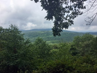
![]()
![]()
![]()
![]()
![]() On Saturday, July 28th I planned to hike somewhere with my brother-in-law Jeff. We agreed to meet at 8:30 AM at the parking area on Route 206 between Roscoe and the Pepacton Reservoir. My plan was to meet at the parking area and then drive to the trailhead on Holiday Brook Road where the Finger Lakes Trail crosses. We would then hike back to the car on Route 206. The hike is about 6.4 miles and has two significant climbs. We also knew the trails would be wet from the rain during the week. In addition, the forecast called for some rain showers using the day. I went to bed too late after working on the website and had two instances of leg cramps during the night. When I awoke at 7:00 AM, I was not sure I wanted to follow through on the plan that I had developed and began considering alternate hikes. The forecast had improved so that the only showers were supposed to be around 8:00 AM. As I began to get ready to go, Sheila seemed pleased that we were hiking and stayed near me so that I would not "forget" to take her. Although the temperature was 68 degrees the humidity was high. The temperatures were forecast to be warm with highs in the 80's and high humidity. I dressed in a long-sleeved crew top with a short-sleeved baselayer. I put on a pair of RailRiders hiking pants which are expensive but last along time and have features like deep pockets and a generous cut which I really like. The pants have Velcro closures at the ankles which I hoped would mean I could fend off the ticks which have been very numerous so far this season. I put on my Keen Glarus hiking boots which have become my "go to" boots which Keen has discontinued. I made sure I had two full bottles of water and got my gear and Sheila in the car. I left Livingston Manor at 8:10 AM and drove west and north on Route 17 to exit 94 for Roscoe. From here I drove north toward Downsville of Route 206. After passing over the top of Brock Mountain, I began watching for the place where the trail crosses the road just down the hill from Jug Tavern Road. I pulled into the small parking area where Jeff was waiting for me. He put his gear in my car and said "Hello" to Sheila. I drove north toward the Pepacton Reservoir and turned right on Route 30. After 4.6 miles, I turned right on Holiday Brook Road and drove another 2.8 miles to the trailhead parking. There were no other cars in the lots when we parked at 8:45 AM. We got our gear ready and both Jeff and I set our GPS units before crossing the road to begin the hike. We immediately ran into a large puddle across the trail which would set the theme for much of the hike! We walked around it and soon found more standing water on the trail. The trail as a whole was wet with areas of standing water and areas where the trail acted as a streambed. We crossed a powerline right-of-way and then entered the woods and started to climb toward the Pelnor Hollow Trail. In 1.1 miles the trail ascended over 500 ft to the top of a hill. Along the way we worked through some steeper areas and some rock scrambles. We began to notice that there were a lot of obstructions in the trail. There were some bushes leaning over and some weeds and nettles but mostly there were many trees lying across the trail. Some of these were easy to step over but others effectively blocked the trail requiring detours.
On Saturday, July 28th I planned to hike somewhere with my brother-in-law Jeff. We agreed to meet at 8:30 AM at the parking area on Route 206 between Roscoe and the Pepacton Reservoir. My plan was to meet at the parking area and then drive to the trailhead on Holiday Brook Road where the Finger Lakes Trail crosses. We would then hike back to the car on Route 206. The hike is about 6.4 miles and has two significant climbs. We also knew the trails would be wet from the rain during the week. In addition, the forecast called for some rain showers using the day. I went to bed too late after working on the website and had two instances of leg cramps during the night. When I awoke at 7:00 AM, I was not sure I wanted to follow through on the plan that I had developed and began considering alternate hikes. The forecast had improved so that the only showers were supposed to be around 8:00 AM. As I began to get ready to go, Sheila seemed pleased that we were hiking and stayed near me so that I would not "forget" to take her. Although the temperature was 68 degrees the humidity was high. The temperatures were forecast to be warm with highs in the 80's and high humidity. I dressed in a long-sleeved crew top with a short-sleeved baselayer. I put on a pair of RailRiders hiking pants which are expensive but last along time and have features like deep pockets and a generous cut which I really like. The pants have Velcro closures at the ankles which I hoped would mean I could fend off the ticks which have been very numerous so far this season. I put on my Keen Glarus hiking boots which have become my "go to" boots which Keen has discontinued. I made sure I had two full bottles of water and got my gear and Sheila in the car. I left Livingston Manor at 8:10 AM and drove west and north on Route 17 to exit 94 for Roscoe. From here I drove north toward Downsville of Route 206. After passing over the top of Brock Mountain, I began watching for the place where the trail crosses the road just down the hill from Jug Tavern Road. I pulled into the small parking area where Jeff was waiting for me. He put his gear in my car and said "Hello" to Sheila. I drove north toward the Pepacton Reservoir and turned right on Route 30. After 4.6 miles, I turned right on Holiday Brook Road and drove another 2.8 miles to the trailhead parking. There were no other cars in the lots when we parked at 8:45 AM. We got our gear ready and both Jeff and I set our GPS units before crossing the road to begin the hike. We immediately ran into a large puddle across the trail which would set the theme for much of the hike! We walked around it and soon found more standing water on the trail. The trail as a whole was wet with areas of standing water and areas where the trail acted as a streambed. We crossed a powerline right-of-way and then entered the woods and started to climb toward the Pelnor Hollow Trail. In 1.1 miles the trail ascended over 500 ft to the top of a hill. Along the way we worked through some steeper areas and some rock scrambles. We began to notice that there were a lot of obstructions in the trail. There were some bushes leaning over and some weeds and nettles but mostly there were many trees lying across the trail. Some of these were easy to step over but others effectively blocked the trail requiring detours.
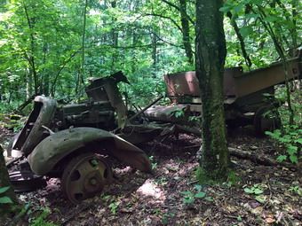 When we reached the Pelnor Hollow Trail, we turned right and began a steep descent to the Splitrock viewpoint. The descent was tricky but at 1.3 miles we were at the lookout. I had left my camera at home when I believed it would rain but now wished I had brought it along. The view was hazy but much clearer than I expected so I took some pictures with my iPhone which seemed to be effective. We stayed at the viewpoint long enough to get a drink and a quick snack and then headed out on the trail again. My boots were starting to wet through from the constant wetness on the trail. Over the next 1.1 miles we descended 470 feet over some difficult ground to a trail junction. The signs at the junction had been vandalized and the area was under water but we soon determined we should turn right on the blue Campbell Mountain Trail which is also a snowmobile trail. The trail was very eroded and covered in running water. We decided to walk a route parallel to the trail and were soon at a point where the trail turned left heading northwest off the snowmobile trail. Just after the trail we began to ascend and eventually the trail swung to the south. At 3.9 miles we began a serious ascent toward the top of an unnamed hill gaining 470 feet over .7 miles. The forests varied between hardwood and evergreen trees with the two often mixed. At 4.2 miles we ascended to an open area called Flat Rock which lived up to its name. I took a few pictures and we again got a drink and a bar. We continued on the trail reaching the highest point at 4.6 miles and then began to descend 300 feet over .5 miles heading northwest. When we reached 5.2 miles, we could see the beginnings of an old quarry on the right. There was a road that turned right off the trail to the quarry. There were obvious placed where stone had been removed and I took a few shots. On the ascent to Brock Mountain we made a short but steep ascent through an area where the trail was completely obscured by brush emphasizing the need for some trail maintenance. There was also the remains of an old truck probably used in the quarrying effort. I took a few pictures of it. Sheila had been following various animal tracks off the trail for the whole hike and at this point she heard something below us and took off. I called her back and encouraged her to return with her electronic collar. She came back but kept heading back in that direction. Jeff and I returned to the trail to begin the last section out to Route 206. The trail was slightly serpentine but we were heading west and descending through mostly hardwood forest. Over the final 1.1 miles we lost a total of 670 feet traveling over well-maintained trail. We came to Route 206 and crossed the road to the parking area. It was 1:20 PM and we had hiked 6.3 miles in 4 and a half hours. Our overall speed was 1.4 mph which seemed slow but the trail was in very poor shape. Our ascent was 1530 feet with a descent of 1800 feet. We got in Jeff's truck and he drove back to my car at the parking area on Holiday Brook Road. Jeff followed me back Livingston Manor where we parted company.
![]()
![]()
![]()
![]() On Friday, July 27th Cindy and I wanted to get in some hiking close to home after a week of rainy weather. We had visited some falls the day before but only hiked a little more than a mile. I was planning on hiking a longer hike with my brother-in-law Jeff the next day. We both had things we needed to accomplish in the morning so we didn't get started until 1:00 PM when the temperature was in the mid 70's and the humidity was increasing. We decided to just go across the street and hike on Round Top. I got dressed in a short-sleeved crew top with a short-sleeved baselayer. I put on a pair of RailRiders hiking pants which are expensive but last along time and have features like deep pockets and a generous cut which I really like. The pants have Velcro closures at the ankles which I hoped would mean I could fend off the ticks which have been very numerous so far this season. I wore a new pair of Keen Targhee II boots in a 9.5W since the 9W had seemed a little short. Sheila would not leave my side as I was getting ready as she wanted to make sure she was going too! We left the house at 1:00 PM and crossed the street with Sheila on her leash. We walked to the back of the church to begin the ascent of the steepest hill behind the church. The hill is short but really gets the circulation pumping and is the steepest and longest climb on the "trail". Sheila responds well to the command "Pull" and the Siberian husky in her makes her well-suited for the job. When we got to the top of the hill, we started out on the trail by turning left at the trailhead. I let Sheila off her leash and she bounded ahead of me following her nose. Whenever I pass by the first major blowdown that I cleared on the trail, I am proud that I was able to do the work by myself with only hand tools. At the first trail junction we followed Sheila as she continued straight ahead on the steeper path to the viewpoint. At the lookout I noted that there was no garbage and everything was in order. From the upper part of the lookout the trees block most of the view despite the efforts of the Town of Rockland sawyer crew to cut down some trees. The problem is that getting to the lower lookout is a little difficult for the average person. We followed the trail to the right and started the gentle climb through the woods. The trail was really beautiful and clear of most branches. The trail bed was lined with very green ferns and pretty clearly delineated.
On Friday, July 27th Cindy and I wanted to get in some hiking close to home after a week of rainy weather. We had visited some falls the day before but only hiked a little more than a mile. I was planning on hiking a longer hike with my brother-in-law Jeff the next day. We both had things we needed to accomplish in the morning so we didn't get started until 1:00 PM when the temperature was in the mid 70's and the humidity was increasing. We decided to just go across the street and hike on Round Top. I got dressed in a short-sleeved crew top with a short-sleeved baselayer. I put on a pair of RailRiders hiking pants which are expensive but last along time and have features like deep pockets and a generous cut which I really like. The pants have Velcro closures at the ankles which I hoped would mean I could fend off the ticks which have been very numerous so far this season. I wore a new pair of Keen Targhee II boots in a 9.5W since the 9W had seemed a little short. Sheila would not leave my side as I was getting ready as she wanted to make sure she was going too! We left the house at 1:00 PM and crossed the street with Sheila on her leash. We walked to the back of the church to begin the ascent of the steepest hill behind the church. The hill is short but really gets the circulation pumping and is the steepest and longest climb on the "trail". Sheila responds well to the command "Pull" and the Siberian husky in her makes her well-suited for the job. When we got to the top of the hill, we started out on the trail by turning left at the trailhead. I let Sheila off her leash and she bounded ahead of me following her nose. Whenever I pass by the first major blowdown that I cleared on the trail, I am proud that I was able to do the work by myself with only hand tools. At the first trail junction we followed Sheila as she continued straight ahead on the steeper path to the viewpoint. At the lookout I noted that there was no garbage and everything was in order. From the upper part of the lookout the trees block most of the view despite the efforts of the Town of Rockland sawyer crew to cut down some trees. The problem is that getting to the lower lookout is a little difficult for the average person. We followed the trail to the right and started the gentle climb through the woods. The trail was really beautiful and clear of most branches. The trail bed was lined with very green ferns and pretty clearly delineated.
When we reached the next trail junction, we stayed to the right to follow the lower trail around the base of Round Top to the next junction. There were a few branches encroaching on the trail and I made a note to return in the next few days to do some more lopping. At the next junction we turned left and started up to the summit of Round Top on the steeper blue trail. There were several places where addition lopping was needed especially near the top. We walked across the summit of Round Top where a few more bushes needed some trimming and down the other side which is also a little steep. When we got to the yellow trail, we turned left to follow it to the second trail junction. This time we turned right and followed the yellow trail back to the very first trail junction. At the trail junction we turned around and retraced our steps taking the more gentle path this time. When the yellow trail turned left, we followed it to the next trail junction were we turned right and headed up the blue trail to the summit. We walked over the top and down the other side to the yellow trail again. We turned right and followed the trail along the base of Round Top. Where the yellow trail turned left, we followed it to the left and down to the lookout. From the lookout we walked down hill to the first trail junction. I was pretty tired at this point and I am sure the high humidity had contributed to this feeling. Cindy was also tired and we decided to walk out to the trailhead and home together. At the trailhead, I put Sheila on her leash and we walked down the cemetery hill and across the field to our driveway. It was about 2:00 PM and we had hiked a little less than 2 miles in an hour.
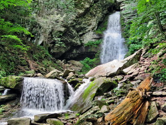
![]()
![]() On Thursday, July 26thI wanted to get out of the house after four days of rainy weather. I asked Cindy if she would like to go see some waterfalls as I knew they should have a high volume after the recent rains. I suggested to driving to Buttermilk Falls on the Peekamoose Road and then hiking to driving Sholam Road in Yagerville to hike to Angel Falls. Cindy agreed but had a Bible study class which ended at noon. When she returned we started to get ready to hike. Sheila was frantic as she had not been out in five days and was running around the house splitting her time between us. The temperatures were forecast to be warm with high humidity so I dressed in a short-sleeved crew top with a short-sleeved baselayer. I put on a pair of RailRiders hiking pants which are expensive but last along time and have features like deep pockets and a generous cut which I really like. The pants have Velcro closures at the ankles which I hoped would mean I could fend off the ticks which have been very numerous so far this season. I put on my Keen Glarus hiking boots which have become my "go to" boots which Keen has discontinued. We got our gear and Sheila in my car and left Livingston Manor at around 1:00 PM. I drove east on State Route 17 to Liberty and then got on Route 55 to Grahamsville. I turned left onto Route 55A just after the Tri-Valley school and drove to Sundown. Where the road split I stayed to the left on Peekamoose Road. I drove 4.3 miles to the parking are for Buttermilk Falls on the left about a mile passed the parking area for Peekamoose Mountain and the Blue Hole. When I parked the car, no others were in the lot. When we got out of the car, the heat and humidity seemed palpable. I got my camera out of my pack and put Sheila on her leash and walked over to the short trail that leads to the falls. We walked until I was in position to take some pictures and I snapped quite a few. I then followed the trail toward the falls being sure to plant my feet securely on the wet and slippery mud and rocks. My new vantage point was a little to the side of the falls and gave a different angle. Sheila and I were able to get right up to the base of the falls and see the little pool formed as the water cascades about 40 feet down the rocks. I took some more pictures including a few of Sheila with the falling water in the background. After taking these photographs, I returned to the car and put Sheila in the back seat. I walked down the road and took a few more pictures from the bridge. Cindy and I walked back to the car and I drove further up the road to take a look at other falls. There are several more falls but the view from the road has been obstructed and they are on private property. I turned around and drove back toward Sundown. I slowed down as we passed Bear Hole Brook but these views also were not that spectacular.
On Thursday, July 26thI wanted to get out of the house after four days of rainy weather. I asked Cindy if she would like to go see some waterfalls as I knew they should have a high volume after the recent rains. I suggested to driving to Buttermilk Falls on the Peekamoose Road and then hiking to driving Sholam Road in Yagerville to hike to Angel Falls. Cindy agreed but had a Bible study class which ended at noon. When she returned we started to get ready to hike. Sheila was frantic as she had not been out in five days and was running around the house splitting her time between us. The temperatures were forecast to be warm with high humidity so I dressed in a short-sleeved crew top with a short-sleeved baselayer. I put on a pair of RailRiders hiking pants which are expensive but last along time and have features like deep pockets and a generous cut which I really like. The pants have Velcro closures at the ankles which I hoped would mean I could fend off the ticks which have been very numerous so far this season. I put on my Keen Glarus hiking boots which have become my "go to" boots which Keen has discontinued. We got our gear and Sheila in my car and left Livingston Manor at around 1:00 PM. I drove east on State Route 17 to Liberty and then got on Route 55 to Grahamsville. I turned left onto Route 55A just after the Tri-Valley school and drove to Sundown. Where the road split I stayed to the left on Peekamoose Road. I drove 4.3 miles to the parking are for Buttermilk Falls on the left about a mile passed the parking area for Peekamoose Mountain and the Blue Hole. When I parked the car, no others were in the lot. When we got out of the car, the heat and humidity seemed palpable. I got my camera out of my pack and put Sheila on her leash and walked over to the short trail that leads to the falls. We walked until I was in position to take some pictures and I snapped quite a few. I then followed the trail toward the falls being sure to plant my feet securely on the wet and slippery mud and rocks. My new vantage point was a little to the side of the falls and gave a different angle. Sheila and I were able to get right up to the base of the falls and see the little pool formed as the water cascades about 40 feet down the rocks. I took some more pictures including a few of Sheila with the falling water in the background. After taking these photographs, I returned to the car and put Sheila in the back seat. I walked down the road and took a few more pictures from the bridge. Cindy and I walked back to the car and I drove further up the road to take a look at other falls. There are several more falls but the view from the road has been obstructed and they are on private property. I turned around and drove back toward Sundown. I slowed down as we passed Bear Hole Brook but these views also were not that spectacular.
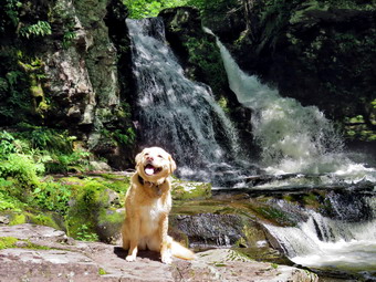 In Sundown I turned left on Greenville Road and drove 3.6 miles to where the road turns sharply to the right and becomes Yagerville Road. The road climbs a good deal and finally levels off before starting to descend to Route 55A along the Rondout Reservoir. As the road started to descend a nice view of the Shawangunks appeared and I pulled over so that I could take some pictures. I continued on Yagerville Road watching for Sholam Road on the left. I turned left on Sholam Road which is marked by "Bridge Out" and "Dead End" signs. I drove to the end of the road and parked by a pile of dirt under the powerlines at 2:45 PM. When we got out of the car the hot humid air hit us again. I set my GPS unit and we immediately started to hike. We walked along what is left of Sholam Road which deteriorates more every year. I was pleased that I could hear a roar coming from the falls apparently indicating a good volume of water. We walked to a point opposite the top of the falls where a path turns right and parallels Trout Creek. I looked down at the falls and saw that it was higher than I had seen it in some time. Trout Creek is rather long extending around 5 miles from Balsam Swamp. Over its course it picks up a few tributaries. We walked along the path until a steep and slippery path turned to the left to head down to the creek bed. We worked our way down the bank with Sheila leading the way. We ended up at some rocks at the base of the falls. All the rocks were slippery which did not bother Sheila but concerned me. I was able to get out my camera and walk out on some of the rocks to get a good view of the falls. I took shots of the falls and some downstream. To capture the volume and character of the falls, I shot a short video before packing up and heading back up to the main trail. Although the trail isn't really maintained, someone had cut a few of the trees that had been across the trail. We continued down the path heading toward the lower falls.
 The trail can be overgrown with weeds but was relatively clear as this is a popular spot for people in the area. I was happy that there was almost no broken glass around the area. We walked to the top of the falls and then down a path to some old foundations at the bottom of the falls. I walked down to the creek bed and out onto some rocks which gave me a good view of the falls. This drop is not as high as the upper falls but is still pretty in its own way. I carefully made my way back to my pack and took a few pictures of the foundations. I headed back up to the top of the falls. I took my camera and walked to a viewpoint that allowed my to take pictures of the upper drop of these lower falls. After taking a few shots I walked back up the bank and to the top of the falls. I walked out on the flat rocks being careful not to slip and fall. I took more pictures of the falls from the side and then took some downstream. I finally felt that I had taken enough pictures so I headed back to my pack. I stowed my camera and we worked our way up a steep path back to Sholam Road and back to the car. It was 3:25 PM and I was satisfied with the trip even though we had hiked only .7 miles in 45 minutes with 180 feet of elevation gain.
![]()
![]()
![]()
![]()
![]() On Saturday, Jul 21st, I had planned to hike the Neversink Unique Area with by brother-in-law, Jeff. We had agreed to meet at my house at 9:00 AM and Jeff showed up right on time. The temperature was in the high 60's so I decided to wear a long-sleeved crew top with a short-sleeved baselayer. I put on a pair of RailRiders hiking pants which are expensive but last along time and have features like deep pockets and a generous cut which I really like. The pants have Velcro closures at the ankles which I hoped would mean I could fend off the ticks which have been very numerous so far this season. I put on my Keen Glarus hiking boots which have become my "go to" boots which Keen has discontinued. When Jeff arrived I got Sheila and my gear in the car and Jeff pout his gear in and we left a little after 9:00 AM. I got on Route 17 and started for Rock Hill. I got off the Quickway at exit 109 and turned right on Katrina Falls Road to drive to the end of the road. I parked at 9:30 AM in the small parking area where there were three other cars. I set my GPS and showed Jeff how to set his and we started down the woods road toward the river at 9:35 AM. The trail was dry with only a few muddy spots here and there. At the bottom of the hill we turned left to stay on the main blue trail. At this point a yellow spur trail goes down to the river. Just after the turn we came to a small bridge over Wolf Brook. The water in the brook was low and I decided not to take any pictures. As we hiked up the small hill after the bridge we crossed a spot where there is always some overflow from the brook and it was bone dry. Jeff and I noticed the poor condition of the bridge which I hope the DEC will fix before it collapses. At the next trail junction, at the top of a short hill, we stayed to the right on the blue trail and descended through a wet area before starting up another small hill. At 1.2 miles another yellow spur trail headed down to the river but we stayed on the blue trail. at 1.4 miles we came to the first bridge across Mullet Brook. The old bridge which was falling apart was replaced with steel i-beams. We walked across the bridge while Sheila went down to the stream to cool off and get a drink. After crossing, the bridge we turned right on the yellow spur trail that goes down to the river at Denton Falls. Jeff and I were having a good time talking and walking along the trail. As we hiked, I was surprised we did not see any other people since there had been several cars in the lot. The trail down to the river is steep and was dry most of the way with some very wet spots. We were careful to keep our footing walk around the wettest places. At 10:30 AM we had hiked 1.65 miles and we were at the edge of the river.
On Saturday, Jul 21st, I had planned to hike the Neversink Unique Area with by brother-in-law, Jeff. We had agreed to meet at my house at 9:00 AM and Jeff showed up right on time. The temperature was in the high 60's so I decided to wear a long-sleeved crew top with a short-sleeved baselayer. I put on a pair of RailRiders hiking pants which are expensive but last along time and have features like deep pockets and a generous cut which I really like. The pants have Velcro closures at the ankles which I hoped would mean I could fend off the ticks which have been very numerous so far this season. I put on my Keen Glarus hiking boots which have become my "go to" boots which Keen has discontinued. When Jeff arrived I got Sheila and my gear in the car and Jeff pout his gear in and we left a little after 9:00 AM. I got on Route 17 and started for Rock Hill. I got off the Quickway at exit 109 and turned right on Katrina Falls Road to drive to the end of the road. I parked at 9:30 AM in the small parking area where there were three other cars. I set my GPS and showed Jeff how to set his and we started down the woods road toward the river at 9:35 AM. The trail was dry with only a few muddy spots here and there. At the bottom of the hill we turned left to stay on the main blue trail. At this point a yellow spur trail goes down to the river. Just after the turn we came to a small bridge over Wolf Brook. The water in the brook was low and I decided not to take any pictures. As we hiked up the small hill after the bridge we crossed a spot where there is always some overflow from the brook and it was bone dry. Jeff and I noticed the poor condition of the bridge which I hope the DEC will fix before it collapses. At the next trail junction, at the top of a short hill, we stayed to the right on the blue trail and descended through a wet area before starting up another small hill. At 1.2 miles another yellow spur trail headed down to the river but we stayed on the blue trail. at 1.4 miles we came to the first bridge across Mullet Brook. The old bridge which was falling apart was replaced with steel i-beams. We walked across the bridge while Sheila went down to the stream to cool off and get a drink. After crossing, the bridge we turned right on the yellow spur trail that goes down to the river at Denton Falls. Jeff and I were having a good time talking and walking along the trail. As we hiked, I was surprised we did not see any other people since there had been several cars in the lot. The trail down to the river is steep and was dry most of the way with some very wet spots. We were careful to keep our footing walk around the wettest places. At 10:30 AM we had hiked 1.65 miles and we were at the edge of the river.
 We walked out onto the rocks by the river and I called Sheila to make sure she did not jump into the river. The water was very low in the river but the falls were still interesting. I grabbed my camera and took pictures upstream and downstream. I then worked my way to the rocks below the falls where I was able to take pictures of the falls and a few more downstream. I had Sheila pose on some rocks and took some pictures with the river in the background. Before we left the river, we made sure to get a drink. We walked back up the steep trail to the main blue trail and both Jeff and I commented that the trail didn't seem as steep on the way down. We turned right to continue the loop back to the car. At the top of the hill I mentioned to Jeff the option of going to High Falls but told him I would rather skip the extend trip on this day. We stayed to the left to start up the hill. After a brief walk uphill of .15 miles, we turned left onto the short trail down to Mullet Brook Falls. I was wondering what Mullet Brook Falls might look like since there had not been much rain lately. Soon the falls came into sight, the water was coming over the falls as only a trickle. The water comes from a large swamp further upstream and is full of tannins which give it a brown color. I dropped my pack where the trail ended and grabbed my camera to take some pictures. We worked my way across the stream which was almost dry and over the rocks. I noticed that someone had built several cairns at the base of the falls. I took some pictures of the falls and then posed Sheila for a few more. I took a few more shots of the falls using settings to soften the water falling over the rocks. We headed back to where I had left my pack where I put away my camera and shouldered my pack to head back out the spur trail. We walked back out to the main trail and turned left to complete the loop. As we climbed we noticed the rocky ledges to our right and I thought about exploring them at some time in the future. Jeff took the lead on the uphill walk and set a brisk pace. As the trail flattened out, Jeff and I noticed that there were several rocks overturned on and near the trail. We couldn't be sure but we both thought the rocks may have been overturned by a bear looking for grubs. Soon we crossed over the upper bridge spanning Mullet Brook. From the bridge the trail is flat or downhill for some time. As we hiked we met several small groups of people hiking toward us. Each time I led Sheila off the trail to let others pass. After a brief walk we were at a trail junction. Walking straight ahead on the trail leads to the Wolf Lake Multiple Use Area. We turned left and began to descend off the ridge. As we started to walk downhill, we met several more groups hiking in the opposite direction. As we hiked downhill, there were several areas of the trail that had brush beginning to encroach on the trail and there were several trees that needed to be removed. We walked downhill for some time and eventually came to the trail junction near the bridge over Wolf Creek where we had started the loop earlier. We continued to walk straight ahead to return to the parking area. Once on the other side of the brook we made the right turn on the woods road back to the car. Neither Jeff nor I were not enthusiastic about the uphill walk back to the car! We arrived at the parking area at 12:20 PM having hiked 4.6 miles in 2 hours and 45 minutes including the stops at the two falls. The vertical gain was only about 980 feet. Jeff said he liked the hike and I agreed that it is one of my favorites.
![]()
![]()
![]()
![]() On Friday, July 20th I wanted to get out for a short hike to try out a new pair of Keen Targhee II shoes to replace my Keen Glarus that are quickly wearing out. I also wanted to try out a new pair of loppers that I bought to do trail work. The loppers are the Corona DualLINK SL 4364. They are heavy duty bypass loppers with a padded grip and handles that extend to 37 inches. They are rated to cut branches up to 1 3/4 inches in diameter! I decided to go across the street and do some trail maintenance on the Round Top trails. I started to get ready around 1:00 PM and Sheila was excited even though we had been out the day before. I asked Cindy if she wanted to go across the street and she agreed. I got dressed in a short-sleeved crew top with a short-sleeved baselayer. I put on a pair of RailRiders hiking pants which are expensive but last along time and have features like deep pockets and a generous cut which I really like. The pants have Velcro closures at the ankles which I hoped would mean I could fend off the ticks which have been very numerous so far this season. I put on my new Keen Targhee II boots in size 9.5 as I thought my regular size 9 seemed too small. Sheila would not leave my side as I was getting ready as she wanted to make sure she was going too! We left the house at 1:30 PM and crossed the street with Sheila on her leash. Cindy carried my Silky Sugowaza saw and I carried the loppers. We crossed the street with Sheila on her leash. We walked to the back of the church to begin the ascent of the steepest hill behind the church. The hill is short but really gets the circulation pumping and is the steepest and longest climb on the "trail". Sheila responds well to the command "Pull" and the Siberian husky in her makes her well-suited for the job. When we got to the top of the hill, we started out on the trail by turning left at the trailhead. I let Sheila off her leash and she bounded ahead of me following her nose. At the first trail junction we followed Sheila as she turned right and continued up the less steep part of the trail. I immediately began to use the loppers to cut various branches hanging onto or near the trail. The loppers worked smoothly and were especially good at cutting larger branches. We followed the blazes for the yellow trail up to the trail junction. Along the way I cut several large branches out of the way. We turned left at the trail junction and followed the yellow trail along the base of Round Top. I cut a few small branches and then a lot of smaller ones. The loppers were really overkill for these smaller branches. At the next trail junction, we turned right on the blue trail and headed up the steepest hill to the summit of Round Top. On the summit we followed the trail over the top and I cut quiet a few branches along the way. We continued down the other side and I continued to cut branches. The loppers worked very well and the cushioned grips made the cutting very comfortable. At the yellow trail we turned right and then left at the next trail junction to head down to the lookout. I decided there wasn't much to cut so we just walked the trail. At the lookout we turned left and descended the hill to the first trail junction. We continued out to the trailhead where I put Sheila on her leash for the return trip. I decided that the Targhees were too large and allowed too much movement of my feet. At the trailhead I put Sheila on her leash and we turned right to descend the hill. We walked across the field to the driveway and home. The skies were still blue with puffy white clouds but the temperature was in the mid 80's with a high humidity. We were home at 2:30 PM having spent an hour and 30 minutes walking a little more than a mile and doing a lot of trimming.
On Friday, July 20th I wanted to get out for a short hike to try out a new pair of Keen Targhee II shoes to replace my Keen Glarus that are quickly wearing out. I also wanted to try out a new pair of loppers that I bought to do trail work. The loppers are the Corona DualLINK SL 4364. They are heavy duty bypass loppers with a padded grip and handles that extend to 37 inches. They are rated to cut branches up to 1 3/4 inches in diameter! I decided to go across the street and do some trail maintenance on the Round Top trails. I started to get ready around 1:00 PM and Sheila was excited even though we had been out the day before. I asked Cindy if she wanted to go across the street and she agreed. I got dressed in a short-sleeved crew top with a short-sleeved baselayer. I put on a pair of RailRiders hiking pants which are expensive but last along time and have features like deep pockets and a generous cut which I really like. The pants have Velcro closures at the ankles which I hoped would mean I could fend off the ticks which have been very numerous so far this season. I put on my new Keen Targhee II boots in size 9.5 as I thought my regular size 9 seemed too small. Sheila would not leave my side as I was getting ready as she wanted to make sure she was going too! We left the house at 1:30 PM and crossed the street with Sheila on her leash. Cindy carried my Silky Sugowaza saw and I carried the loppers. We crossed the street with Sheila on her leash. We walked to the back of the church to begin the ascent of the steepest hill behind the church. The hill is short but really gets the circulation pumping and is the steepest and longest climb on the "trail". Sheila responds well to the command "Pull" and the Siberian husky in her makes her well-suited for the job. When we got to the top of the hill, we started out on the trail by turning left at the trailhead. I let Sheila off her leash and she bounded ahead of me following her nose. At the first trail junction we followed Sheila as she turned right and continued up the less steep part of the trail. I immediately began to use the loppers to cut various branches hanging onto or near the trail. The loppers worked smoothly and were especially good at cutting larger branches. We followed the blazes for the yellow trail up to the trail junction. Along the way I cut several large branches out of the way. We turned left at the trail junction and followed the yellow trail along the base of Round Top. I cut a few small branches and then a lot of smaller ones. The loppers were really overkill for these smaller branches. At the next trail junction, we turned right on the blue trail and headed up the steepest hill to the summit of Round Top. On the summit we followed the trail over the top and I cut quiet a few branches along the way. We continued down the other side and I continued to cut branches. The loppers worked very well and the cushioned grips made the cutting very comfortable. At the yellow trail we turned right and then left at the next trail junction to head down to the lookout. I decided there wasn't much to cut so we just walked the trail. At the lookout we turned left and descended the hill to the first trail junction. We continued out to the trailhead where I put Sheila on her leash for the return trip. I decided that the Targhees were too large and allowed too much movement of my feet. At the trailhead I put Sheila on her leash and we turned right to descend the hill. We walked across the field to the driveway and home. The skies were still blue with puffy white clouds but the temperature was in the mid 80's with a high humidity. We were home at 2:30 PM having spent an hour and 30 minutes walking a little more than a mile and doing a lot of trimming.
![]()
![]()
![]()
![]()
![]() On Thursday, July 19th I wanted to finally do the hike from Alder Lake to the lookout over Beecher Lake and the Zen Monastery. The Catskill Mountain Club had arranged to have the lookout cutout to restore the view as it had been years before. I was not able to participate as a volunteer due to a prior commitment but I was anxious to see the result. Cindy was not interested in this long a hike but I knew Sheila would not mind! I got up at 5:15 AM and got ready to go to the men's bible study at our church at 6:15 AM. When I returned to Livingston Manor at 7:30 AM, I noticed that there was still a lot of fog lying in the valleys so I decided to delay my departure and went to each breakfast at Cafe 43. I returned home and began to get ready under the watchful eye of Sheila. The temperatures were forecast to be a little cooler with lower humidity so I dressed in a long-sleeved crew top with a short-sleeved baselayer. I put on a pair of RailRiders hiking pants which are expensive but last along time and have features like deep pockets and a generous cut which I really like. The pants have Velcro closures at the ankles which I hoped would mean I could fend off the ticks which have been very numerous so far this season. I put on my Keen Glarus hiking boots which have become my "go to" boots which Keen has discontinued. I got Sheila and my gear in the car a little after 9:00 AM and drove out Old Route 17 to the Beaverkill Road. I turned right and rove north on the Beaverkill Road through Lew Beach and Turnwood. When I came to Alder Creek Road on the left, I turned and followed the road until it took a sharp right. After the turn I continue straight ahead onto the access road for Alder Lake. When I arrived at the parking area I was surprised that the parking area was full an cars were beginning to park along the side of the road. I found a spot on the grass at the very end of the parking area. I set my GPS and put Sheila on her leash. The temperature was 68 degrees, a slight breeze was blowing and the humidity was very low. We headed toward Alder Lake passing by the remains of the Coykendall Mansion. I was sorry to see part of the ornate stone wall had collapsed and was marked with ugly caution tape. There was quite a noise coming from the area of the dam and it sounded like there were young people below the spillway. As we walked out onto the "lawn", I could see there was a group of people playing a game on the other side of the dam. I decided not to stop to take any pictures until we reached the viewpoint as this was definitely a destination hike. There were some geese on the lake but otherwise the scene was much the same as the last week when I had hiked with Bryce.
On Thursday, July 19th I wanted to finally do the hike from Alder Lake to the lookout over Beecher Lake and the Zen Monastery. The Catskill Mountain Club had arranged to have the lookout cutout to restore the view as it had been years before. I was not able to participate as a volunteer due to a prior commitment but I was anxious to see the result. Cindy was not interested in this long a hike but I knew Sheila would not mind! I got up at 5:15 AM and got ready to go to the men's bible study at our church at 6:15 AM. When I returned to Livingston Manor at 7:30 AM, I noticed that there was still a lot of fog lying in the valleys so I decided to delay my departure and went to each breakfast at Cafe 43. I returned home and began to get ready under the watchful eye of Sheila. The temperatures were forecast to be a little cooler with lower humidity so I dressed in a long-sleeved crew top with a short-sleeved baselayer. I put on a pair of RailRiders hiking pants which are expensive but last along time and have features like deep pockets and a generous cut which I really like. The pants have Velcro closures at the ankles which I hoped would mean I could fend off the ticks which have been very numerous so far this season. I put on my Keen Glarus hiking boots which have become my "go to" boots which Keen has discontinued. I got Sheila and my gear in the car a little after 9:00 AM and drove out Old Route 17 to the Beaverkill Road. I turned right and rove north on the Beaverkill Road through Lew Beach and Turnwood. When I came to Alder Creek Road on the left, I turned and followed the road until it took a sharp right. After the turn I continue straight ahead onto the access road for Alder Lake. When I arrived at the parking area I was surprised that the parking area was full an cars were beginning to park along the side of the road. I found a spot on the grass at the very end of the parking area. I set my GPS and put Sheila on her leash. The temperature was 68 degrees, a slight breeze was blowing and the humidity was very low. We headed toward Alder Lake passing by the remains of the Coykendall Mansion. I was sorry to see part of the ornate stone wall had collapsed and was marked with ugly caution tape. There was quite a noise coming from the area of the dam and it sounded like there were young people below the spillway. As we walked out onto the "lawn", I could see there was a group of people playing a game on the other side of the dam. I decided not to stop to take any pictures until we reached the viewpoint as this was definitely a destination hike. There were some geese on the lake but otherwise the scene was much the same as the last week when I had hiked with Bryce.
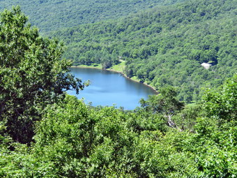 Sheila and I walked down to the trail along the north side of the lake and headed toward the upper end of the lake. The bushes and briars were beginning to close in on the trail and I wondered if the DEC was supposed to maintain the trail or if it was assigned to a volunteer. There were a few muddy spots but much of the trail was not even damp. Several of the primitive campsites were occupied by large groups. We crossed the first bridge and I saw that the beaver dams were still intact. The beavers have done such a good job that the trail between the two bridges is flooded making the walk more difficult. After crossing the second bridge, we walked up a little hill to the point where the Millbrook Ridge Trill branches to the left. We turned left and I let Sheila off her leash as we began the challenging part of the hike. The trail begins to climb almost immediately as it parallels the stream but the grade is initially minimal. There are at least three beaver meadows along the way but I ignored them as I was on a mission. The first beaver meadow is just off the trail at 1.85 miles and we walked on by it. After gaining about 200 feet over the next .4 miles, the trail leveled and there were two more beaver meadows. The first in this pair has a lean-to at the far end which is popular but beginning to show signs of needed repairs. The final beaver meadow has been my favorite as it is practically on the trail and I have taken some nice pictures of it. Just after the meadow the trail begins a more serious ascent. The highest point on the ridge is around 3480 feet meaning that only 20 more feet of elevation would make it a contender for the Catskill 3500 list. This part of the trail was a little longer than I remembered with several different climbs making me think we were at the top. The trail had not been maintained for some time with nettles closing in and several blowdowns that had not been touched and several others that were partially cleared. The trail is rocky and can be hard on the feet and legs on the ascent and descent. After 1.2 miles and over 700 feet of ascent we were at the highest point on the ridge! It was 11:15 AM and we had hiked a total of 3.5 miles. We began the descent down the other side of the hill which, of course, meant that this would be an ascent on the turn trip. The descent was much greater than I remembered and the walk a little longer. We lost 350 feet over the next .5 miles until the trail began to climb again. I already knew that I had underestimated the length of the hike and was disgusted that I had not checked my own website! I wasn't tired but I did keep wondering if I had somehow missed the lookout. The trail began to ascend and along the way there were several interesting rock formations. On formation looked as it "rockpeckers" had been working on the rocks. Again both the ascent and the distance were a little more than I remembered. The trail meandered back and forth until I was almost convinced I had somehow missed the viewpoint. After regaining 250 feet over .5 miles we were at the lookout.
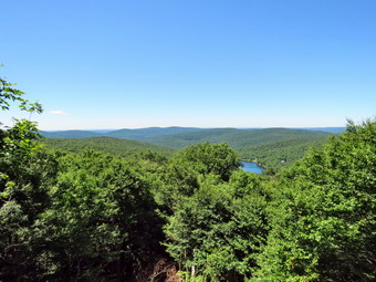 It was 11:50 AM and we had covered 4.6 miles! The crew that cutout the lookout had done a magnificent job opening up the view down to the lake and across to the hills beyond. I took out my camera and took pictures of Sheila on top of the rock at the lookout with the lake and hills behind her. I took pictures of the lookout and the trees the drew had cut below. There were still a few larger trees farther away from the viewpoint that partially blocked the view but it was not possible to cut them. I used the Peak Finder app on my iPhone to identify some of the mountains in the distance before getting a bar and a drink. At noon I packed up and we started back down the trail toward Alder Lake. I had hoped that we could make some time on the way back but the climb back up to the highest point on Millbrook Ridge took some time. After that, there were the rocky and steep descent. Sheila had no problem but I had to be careful not to slip and somehow my poles were getting caught in crevices in the rocks. I noticed that On the way back the temperature was increasing and it was a little more humid. I was trying to keep track of my time and speed and we finally reached the beaver meadow and the lean-to. From here the descents were shallower and I was able to pick up some speed. By 2:05 PM we had hiked 8.25 miles are had arrived back at the trail around the lake. I looked to my left to check the condition of the bridge over the creek. The handrails were still missing from a tree that had fallen across the bridge. We turned right to make our way back along the north side of the lake. I immediately noticed that It was much quieter than it had been on the way out. As we approached the campsites, the noise increased but it was the noise of people having fun. I looked across at Cradle Rock Ridge and saw a man standing in the water about 20 feet from shore. I never though about the depth of the water in the lake but the water rose only as high as the man's thighs! We continued on the trail to the lawn where several people were relaxing on shore enjoying the sun. As we walked back up to the parking area, I could see a dog running around with the owner trying to convince him to obey. She eventually was able to get the dog in her car and Sheila and I continued on to the car. It was 2:25 PM and we had hiked 9.1 miles in 4 hours and 55 minutes with a vertical gain of 1992 feet. The temperature was 78 degrees but it was much hotter in the car which was black leather seating!
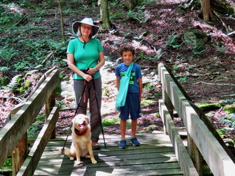
![]()
![]()
![]()
![]()
![]() On Wednesday, July 18th I wanted to get out on a longer hike and decided to hike from Alder Lake to Millbrook Ridge and back. The lookout over Beecher Lake had recently been cleared and I wanted to see what it looked like. I got up at 8:00 AM and did a few things around the house before starting to get ready to hike. Sheila was excited as we had not been out for two days and she was ready to go. I was not sure which grandchild would be coming to the house so I waited around since I knew Bryce would want to go hiking. When Karl arrived at 9:15 AM he had Bryce with him but announced he would be picking him up at 2:30 PM. I didn't want to change my plans again but decided the 8 miles to Millbrook Ridge given the time constraint might be a little too far. I thought that hiking a figure 8 at Kelly Hollow would be fun and would allow Cindy to go along. I asked her and she agreed so we started to get ready to go. The hike is only about 4 miles but there are some interesting sites including a stream that runs between the trail out and the trail back. There is also a beaver pond on the trail with a lean-to. The temperatures were forecast to be a little cooler with lower humidity so I dressed in a long-sleeved crew top with a short-sleeved baselayer. I put on a pair of RailRiders hiking pants which are expensive but last along time and have features like deep pockets and a generous cut which I really like. The pants have Velcro closures at the ankles which I hoped would mean I could fend off the ticks which have been very numerous so far this season. I put on my Keen Glarus hiking boots which have become my "go to" boots which Keen has discontinued. Sheila would not leave my side as I was getting ready as she wanted to make sure she was going too! We got Sheila and our gear in the car and headed north on State Route 17 toward Roscoe. I prefer using the Beaverkill and Barkaboom Roads which saves over 0 miles but Cindy prefers fewer back roads. I took exit 94 and drove north toward the Pepacton Reservoir on Route 206. At the junction with Route 30, I turned left and followed Route 30 to the Dunraven Bridge. Here I turned right and the BWS roads until reaching the junction with the Barkaboom Road. I turned left on BWS 9. After 4.5 miles, I turned right on Millbrook Road and continued 5.25 miles to the parking lot for Kelly Hollow on the right. We parked at 10:45 AM with no other cars in the lot which suited me perfectly. I took a moment to set my GPS before starting our hike at 10:50 AM by heading out on the trail marked with yellow XC skiing blazes. The temperature was barely 70 degrees and the humidity was very low. The skies were blue with numerous iffy white clouds. My plan was to walk the trail in a figure 8 which is something I had done only once before. We followed the trail as it crossed a small stream and then turned right on the woods road heading south and ascending slightly passing through a gate. Along the way the trail was wet in spots from the rain the night before. It is always a pleasure to hike with Bryce as he is able to converse on many subjects and loves to discus Bible stories although he is only 7 years old.
On Wednesday, July 18th I wanted to get out on a longer hike and decided to hike from Alder Lake to Millbrook Ridge and back. The lookout over Beecher Lake had recently been cleared and I wanted to see what it looked like. I got up at 8:00 AM and did a few things around the house before starting to get ready to hike. Sheila was excited as we had not been out for two days and she was ready to go. I was not sure which grandchild would be coming to the house so I waited around since I knew Bryce would want to go hiking. When Karl arrived at 9:15 AM he had Bryce with him but announced he would be picking him up at 2:30 PM. I didn't want to change my plans again but decided the 8 miles to Millbrook Ridge given the time constraint might be a little too far. I thought that hiking a figure 8 at Kelly Hollow would be fun and would allow Cindy to go along. I asked her and she agreed so we started to get ready to go. The hike is only about 4 miles but there are some interesting sites including a stream that runs between the trail out and the trail back. There is also a beaver pond on the trail with a lean-to. The temperatures were forecast to be a little cooler with lower humidity so I dressed in a long-sleeved crew top with a short-sleeved baselayer. I put on a pair of RailRiders hiking pants which are expensive but last along time and have features like deep pockets and a generous cut which I really like. The pants have Velcro closures at the ankles which I hoped would mean I could fend off the ticks which have been very numerous so far this season. I put on my Keen Glarus hiking boots which have become my "go to" boots which Keen has discontinued. Sheila would not leave my side as I was getting ready as she wanted to make sure she was going too! We got Sheila and our gear in the car and headed north on State Route 17 toward Roscoe. I prefer using the Beaverkill and Barkaboom Roads which saves over 0 miles but Cindy prefers fewer back roads. I took exit 94 and drove north toward the Pepacton Reservoir on Route 206. At the junction with Route 30, I turned left and followed Route 30 to the Dunraven Bridge. Here I turned right and the BWS roads until reaching the junction with the Barkaboom Road. I turned left on BWS 9. After 4.5 miles, I turned right on Millbrook Road and continued 5.25 miles to the parking lot for Kelly Hollow on the right. We parked at 10:45 AM with no other cars in the lot which suited me perfectly. I took a moment to set my GPS before starting our hike at 10:50 AM by heading out on the trail marked with yellow XC skiing blazes. The temperature was barely 70 degrees and the humidity was very low. The skies were blue with numerous iffy white clouds. My plan was to walk the trail in a figure 8 which is something I had done only once before. We followed the trail as it crossed a small stream and then turned right on the woods road heading south and ascending slightly passing through a gate. Along the way the trail was wet in spots from the rain the night before. It is always a pleasure to hike with Bryce as he is able to converse on many subjects and loves to discus Bible stories although he is only 7 years old.
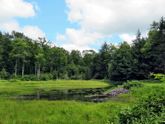 At .3 miles we came to the short sour trail to a designated campsite and headed down the trail to check it out. There was enough water flowing in the stream to get water for camping and the area seems like a great place to stay overnight. We walked back up to the main trail and turned right to continue our hike. At .6 miles we came to the cutoff to the right for the Short Loop hike. We turned right to walk down the cutoff trail to the bridge. I took some pictures of Cindy, Bryce and Sheila before we crossed the ridge and headed up the trail to the main loop trail on the other side. Sheila went swimming in the stream and then ran up the bank dashing back and forth madly to Bryce's great delight. We turned left on the loop trail heading southwest and then south toward the beaver pond and lean-to. Over the next .4 miles we gained almost 300 feet for a 12% grade. Although this is not a steep climb it was more than I remembered. At 1.3 miles we were at the beaver pond which is quickly becoming a beaver meadow. There are no more beavers in the area and the pond is now a small puddle. There were some nice puffy white clouds in the blue sky so I took some pictures before we continued around the pond. The grass and briars were beginning to take over the trail and Bryce had on shorts making the short trip around the pond unpleasant. We stopped again on the other side and I took a few more pictures before continuing on to the lean-to in the woods. The lean-to was in good shape but beginning to deteriorate. We stopped to eat a snack and get a drink. Cindy and Bryce sat at the picnic table while I took some pictures of the lean-to and walked over to the privy. A tree had fallen just missing the privy. I opened the door and found the inside was a mess. I don't know who maintains this area but it the trails need some care and the privy could use some cleaning. There is a project to rebuild some lean-tos and this one could use some care. After a break, we continued on the trail now heading northeast and downhill. The trail made a turn so that we were heading southeast and we crossed a few bridges over small streams. Bryce began counting bridges as there were quite a few and more than I remembered. At one point we started to walk through a grove of pines and I stopped to take a few shots including a couple straight up. At 2 miles we came to the spot where I had bushwhacked up to Millbrook Ridge to look down on Alder Lake. At 2.3 miles we made and almost 180 degree turn and started heading north. I noted that this would be a good place to try another bushwhack as it was only .7 miles to the trail that runs along Millbrook Ridge. We continued north on the trail still descending. We were headed toward the crossover trail which we would again use to finish or figure 8.
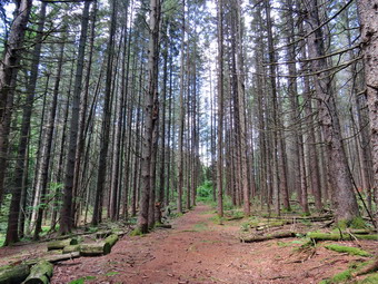 Sheila alerted and I looked up to see a male hiker and his two dogs approaching. I immediately put Sheila on her leash but, of course, the other two dogs were running free. One dog approached Sheila and it clear they would not get along. The owner did get this dog leashed and the other seemed happy to keep his distance. We stopped to talk for a few minutes as I noticed both dogs were equipped with a combination training and GPS collar. I mentioned that Sheila had a training collar and told the owner I had first run across these devices when a dog appareled by my side on Friday Mountain a few years ago. I explained the dog kept "flinching" and that the owner finally appeared and explained the electronic collar. As we talked it became clear that the owner, Doug, was the same man I had met on Friday! He has two rather rare bur beautiful dogs. One is a Louisiana Catahoula Leopard Dog, the state dog of Louisiana, and the other a Plott Hound, the state dog of North Carolina. Both dogs are hunting dogs and often follow scent trails for miles so Doug has the collars that will track them. After talking, we continued in opposite directions. Within a short distance, we saw a couple approaching with two small dogs who were also running free. They ran at Sheila since their owners had no control over them. Sheila, Cindy and I discouraged their approach. The owners caught up and moved them up the trail without a word of apology and an attitude that showed we were at fault! At 3 miles we again came to the crossover trail and turned left to cross the middle of the figure 8. We crossed the bridge and walked up the hill on the other side to the main trail. This time we turned right and started to walk 1.1 miles back to the car. The day was very pleasant with a slight breeze blowing. This part of the trail was not well marked but the path was pretty obvious as it followed a woods road. At 3.9 miles we came to the Middletown Cemetery and Bryce and I decided to explore a little. Several gravestone had special markers designated the interred as Civil War veterans. One grave had a marker indicating the deceased had fought in the Revolution and had died in 1792! After looking at a few more stones, we continued out the access road to Millbrook Road. We turned right and walked the final .3 miles back to the car. It was 1:35 PM and we had spent 2 hours and 44 minutes hiking 4.3 miles with an elevation gain of 670 feet. We had paused for a little over 30 minutes. On the way back I decided to take the Barkaboom and Beaverkill Road route which saved us a little time. The temperature on the return trip was still only 73 degrees.
![]()
![]()
![]()
![]() On Monday, July 16th I wanted to get out on a longer hike and decided to hike from Alder Lake to Millbrook Ridge and back. The lookout over Beecher Lake had recently been cleared and I wanted to see what it looked like. I got up at 8:00 AM and did a few things around the house before starting to get ready to hike. Sheila was excited as we had not been out for two days and she was ready to go. As I was about to get dressed the ambulance pager went off and I responded. By the time I returned home, I wasn't sure there was enough time to hike since the forecast called for afternoon thunderstorms. I asked Cindy if she wanted to go across the street and hike Round Top but she declined. I got dressed in a short-sleeved crew top with a short-sleeved baselayer. I put on a pair of RailRiders hiking pants which are expensive but last along time and have features like deep pockets and a generous cut which I really like. The pants have Velcro closures at the ankles which I hoped would mean I could fend off the ticks which have been very numerous so far this season. I tried on my new Keen Targhee II boots but decided I might need a half size large and I switched to my Keen Glarus hiking boots. Sheila would not leave my side as I was getting ready as she wanted to make sure she was going too! We left the house at 12:50 PM and crossed the street with Sheila on her leash. We walked to the back of the church to begin the ascent of the steepest hill behind the church. The hill is short but really gets the circulation pumping and is the steepest and longest climb on the "trail". Sheila responds well to the command "Pull" and the Siberian husky in her makes her well-suited for the job. When we got to the top of the hill, we started out on the trail by turning left at the trailhead. I let Sheila off her leash and she bounded ahead of me following her nose. At the first trail junction I followed Sheila as she turned right and continued up the less steep part of the trail. It was really a pleasure to walk on the trails and we found there were no major blowdowns. I did spend some time clearing sticks and small branches from the trail.
On Monday, July 16th I wanted to get out on a longer hike and decided to hike from Alder Lake to Millbrook Ridge and back. The lookout over Beecher Lake had recently been cleared and I wanted to see what it looked like. I got up at 8:00 AM and did a few things around the house before starting to get ready to hike. Sheila was excited as we had not been out for two days and she was ready to go. As I was about to get dressed the ambulance pager went off and I responded. By the time I returned home, I wasn't sure there was enough time to hike since the forecast called for afternoon thunderstorms. I asked Cindy if she wanted to go across the street and hike Round Top but she declined. I got dressed in a short-sleeved crew top with a short-sleeved baselayer. I put on a pair of RailRiders hiking pants which are expensive but last along time and have features like deep pockets and a generous cut which I really like. The pants have Velcro closures at the ankles which I hoped would mean I could fend off the ticks which have been very numerous so far this season. I tried on my new Keen Targhee II boots but decided I might need a half size large and I switched to my Keen Glarus hiking boots. Sheila would not leave my side as I was getting ready as she wanted to make sure she was going too! We left the house at 12:50 PM and crossed the street with Sheila on her leash. We walked to the back of the church to begin the ascent of the steepest hill behind the church. The hill is short but really gets the circulation pumping and is the steepest and longest climb on the "trail". Sheila responds well to the command "Pull" and the Siberian husky in her makes her well-suited for the job. When we got to the top of the hill, we started out on the trail by turning left at the trailhead. I let Sheila off her leash and she bounded ahead of me following her nose. At the first trail junction I followed Sheila as she turned right and continued up the less steep part of the trail. It was really a pleasure to walk on the trails and we found there were no major blowdowns. I did spend some time clearing sticks and small branches from the trail.
We followed the blazes for the yellow trail up to the trail junction. We turned left at the trail junction and followed the yellow trail along the base of Round Top. At the next trail junction, we turned right on the blue trail and headed up the steepest hill to the summit of Round Top. On the summit we followed the trail over the top and then down the other side. This part went quickly. At the yellow trail we turned right and then left at the next trail junction to head down to the lookout. At the lookout we turned left and descended the hill to the first trail junction. We turned around and headed back up the hill to the lookout. We turned right at the top following the yellow trail on the long, gentle climb to the junction with the blue trail. We turned right and followed the yellow trail along the base of Round Top to the next junction. Here we turned left and followed the blue trail to the summit. We continued on the trail and once again we crossed the summit and started down the other side. We turned left on the yellow trail and then right at the next trail junction. It was enjoyable following the old woods road back down to the first trail junction. Even though doing repeat figure 8's is a little boring it allows me to think about other matters. We immediately turned around and did a third figure 8 which matched the first. I did notice that after the first one I was tired but now I was feeling pretty good. Sheila was taking a few breaks by laying down in the shade until I caught up. This sometimes means she is hot and thirsty. By the end of the third figure 8 it was definitely hotter and more humid. I decided to one more and we repeated the same route as the second figure 8. This time when we returned to the first trail junction we continued out to the trailhead. At the trailhead I put Sheila on her leash and we turned right to descend the hill. We walked across the field to the driveway and home. The skies were still blue with puffy white clouds but the temperature was in the high 80's with a high humidity. We were home at 1:35 PM having spent an hour and 45 minutes walking a little more than 3 miles. I plan on doing the Millbrook Ridge hike later in the week when the temperatures are forecast to be in the 70's!
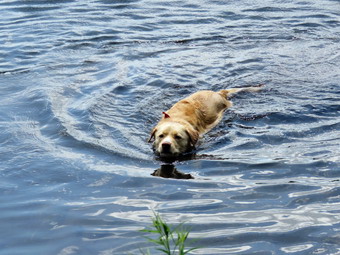
![]()
![]()
![]()
![]()
![]() On Friday, July 13th I wanted to get in a hike with Cindy somewhere. We had the whole day free so I knew we could hike close to home or travel farther away. Cindy said it had to be a hike that wasn't too strenuous. I asked her where she wanted to go and she suggested the Basha Kill. I asked if an 8.5 mile loop was acceptable and she said "No." I suggested going to Bowman Lake State Park to hike some of the trails around the lake which are flat but beautiful. Cindy said this was too far away. After a few more suggestions were turned down, I made up my mind to simply go and hike Millbrook Ridge from Alder Lake with Sheila. I made one last suggestion that we go to Frick Pond and hike the loop and Cindy agreed. I was not enthusiastic about this choice but I knew that it meant that I would get in at least 6 miles. By the time we finally decided where we were going it was 9:30 AM And the temperature was just reaching 70 degrees. I got dressed in a short-sleeved crew top with a short-sleeved baselayer. I put on a pair of RailRiders hiking pants which are expensive but last along time and have features like deep pockets and a generous cut which I really like. The pants have Velcro closures at the ankles which I hoped would discourage the ticks. I decided to wear my Keen Glarus hiking boots which are my "go to" hiking boots since I had not broken in the new Keen Targhee II boots. The skies were blue with a few clouds and I knew the forecast did not call for any rain. Sheila was eager to get in the car and doubly happy since both Cindy and I were going. We left Livingston Manor at 10:15 AM to head for Frick Pond. I had already decided that I would limit my photography and perhaps avoid stopping at all to take pictures. I drove out the DeBruce Road and turned left after six miles on Mongaup Pond Road. Just before the road split, Cindy and I both noticed a movement on the left side of the road. I slowed and we saw a single red fox in the woods. I backed up to get a better look and it stared at us for a moment before disappearing. At the split in the road I stayed to the left on Beech Mountain Road. We were at the parking area and out on the Quick Lake Trail by 10:35 AM. There were no other cars so I did not expect to meet anyone. Sheila was more than ready to get going even though we had hiked 14 miles two days before. The temperature seemed cooler and the humidity lower than on Wednesday when I hiked 14 miles to Quick Lake. There was also a slight breeze which unfortunately did not discourage the insects. The woods road passed the register box to Frick Pond was damp but there were only a few areas of standing water and only a little mud. At Gravestone Junction we stayed to the left on the red Quick Lake Trail crossing the stepping stones the Willowemoc Trail Crew had installed. We walked down to the pond and crossed the bridge over the outlet. The scene was much the same as always and there was nothing distinguishing to photograph. I stayed with my plan and continued on the trail. As we walked on the trail along the west side of the pond the one area that was usually wet and muddy was almost dry. At the next trail junction with the Big Rock Trail, we headed left to stay on the Quick Lake Trail. We were keeping a pretty steady pace as we headed for Iron Wheel Junction. Sheila was running around following game trails and chasing a few chipmunks and squirrels. I removed a few branches from the trail as I walked along. The trail was drier than I expected. Once we got to the "spruce tunnel" there were several trees down on the trail. The small stream through the forest was almost dry. I was also happy that the ferns and grasses were also dry compared to my experience two days before when everything was soaked! When we arrived at Iron Wheel Junction, we turned left to head toward Hodge Pond staying on the Quick Lake Trail.
On Friday, July 13th I wanted to get in a hike with Cindy somewhere. We had the whole day free so I knew we could hike close to home or travel farther away. Cindy said it had to be a hike that wasn't too strenuous. I asked her where she wanted to go and she suggested the Basha Kill. I asked if an 8.5 mile loop was acceptable and she said "No." I suggested going to Bowman Lake State Park to hike some of the trails around the lake which are flat but beautiful. Cindy said this was too far away. After a few more suggestions were turned down, I made up my mind to simply go and hike Millbrook Ridge from Alder Lake with Sheila. I made one last suggestion that we go to Frick Pond and hike the loop and Cindy agreed. I was not enthusiastic about this choice but I knew that it meant that I would get in at least 6 miles. By the time we finally decided where we were going it was 9:30 AM And the temperature was just reaching 70 degrees. I got dressed in a short-sleeved crew top with a short-sleeved baselayer. I put on a pair of RailRiders hiking pants which are expensive but last along time and have features like deep pockets and a generous cut which I really like. The pants have Velcro closures at the ankles which I hoped would discourage the ticks. I decided to wear my Keen Glarus hiking boots which are my "go to" hiking boots since I had not broken in the new Keen Targhee II boots. The skies were blue with a few clouds and I knew the forecast did not call for any rain. Sheila was eager to get in the car and doubly happy since both Cindy and I were going. We left Livingston Manor at 10:15 AM to head for Frick Pond. I had already decided that I would limit my photography and perhaps avoid stopping at all to take pictures. I drove out the DeBruce Road and turned left after six miles on Mongaup Pond Road. Just before the road split, Cindy and I both noticed a movement on the left side of the road. I slowed and we saw a single red fox in the woods. I backed up to get a better look and it stared at us for a moment before disappearing. At the split in the road I stayed to the left on Beech Mountain Road. We were at the parking area and out on the Quick Lake Trail by 10:35 AM. There were no other cars so I did not expect to meet anyone. Sheila was more than ready to get going even though we had hiked 14 miles two days before. The temperature seemed cooler and the humidity lower than on Wednesday when I hiked 14 miles to Quick Lake. There was also a slight breeze which unfortunately did not discourage the insects. The woods road passed the register box to Frick Pond was damp but there were only a few areas of standing water and only a little mud. At Gravestone Junction we stayed to the left on the red Quick Lake Trail crossing the stepping stones the Willowemoc Trail Crew had installed. We walked down to the pond and crossed the bridge over the outlet. The scene was much the same as always and there was nothing distinguishing to photograph. I stayed with my plan and continued on the trail. As we walked on the trail along the west side of the pond the one area that was usually wet and muddy was almost dry. At the next trail junction with the Big Rock Trail, we headed left to stay on the Quick Lake Trail. We were keeping a pretty steady pace as we headed for Iron Wheel Junction. Sheila was running around following game trails and chasing a few chipmunks and squirrels. I removed a few branches from the trail as I walked along. The trail was drier than I expected. Once we got to the "spruce tunnel" there were several trees down on the trail. The small stream through the forest was almost dry. I was also happy that the ferns and grasses were also dry compared to my experience two days before when everything was soaked! When we arrived at Iron Wheel Junction, we turned left to head toward Hodge Pond staying on the Quick Lake Trail.
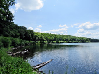 We kept a quick pace up the hilly part of the trail. The trail was washed out in several places and I continued to remove small obstacles. At one point we stopped to get a drink and split a bar. I put on some insect repellant as the mosquitoes were becoming an annoyance. We continued on the trail until it leveled off and descended slightly to Junkyard Junction at 3.1 miles. On Wednesday I had turned left here to hike bore than 4 miles more to Quick Lake. On this day we turned right at this intersection and headed across the Flynn Trail toward Hodge Pond. The Flynn Trail was slightly damp in a few places bit there was virtually no mud. The trip across this part of the Flynn Trail went quickly. Soon we were at the gate where the trail turns right and heads down toward Hodge Pond. We reached the area near the shore of the pond and turned left to follow the jeep trail around the back of the pond. The sky was still blue and there were a few more puffy white clouds so I decided to stop for a few moments at the head of the pond. The pond was very placid and there were almost no sounds. Sheila went for a swim and I took a few pictures of her and the pond. On the east side of the pond I turned left up the hill toward the ruins of the Beech Mountain Boy Scout Camp. The climb up this trail is steeper than the trail from the outlet of Hodge Pond but it is also shorter! When we got to the top of the hill, we turned right to head back toward the Flynn Trail. Once we were back at the Flynn Trail, we turned left for a straight shot back to the car. We set a fast pace to the junction with the Big Rock Trail and then had about 1.7 miles to go to get back to the car. This stretch can often seem long and boring but I alternated between talking to Cindy and getting lost in my own thoughts. Everything was very green with a few areas where the grass seemed to have died off. We did stop at some rock ledges for a quick drink before making the last push back to the car. As we neared the gate, we came to the huge spruce tree that lies across the trail. Cindy and I had cut an opening through it to allow hikers to pass. This was still in good shape and allowed us to pass easily. We followed the Flynn Trail to the gate and then turned left to continue on the trail to avoid the private property around the cabin. We followed the trail through the woods and back to the car arriving at 1:45 PM. We hiked 6.3 miles in hours and 5 minutes with 890 feet of elevation gain. We stopped for only 14 minutes and our overall and moving average speeds were both 2.2 mph.
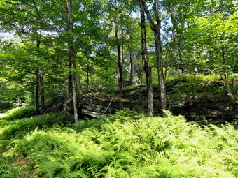
![]()
![]()
![]()
![]()
![]() On Wednesday, July 11th I had decided that I wanted to go on a much longer hike than I had been doing to see if I was at all ready for some sections of the Finger Lakes Trail. I settled on going to the Frick Pond area and hiking from the trailhead to Quick Lake and back which I knew was a 14 mile hike. This was double the distance compare to most hikes I had been doing! The forecast was for temperatures in the high 70 or low 80's which moderate humidity and no rain. It did rain overnight and I knew that would mean everything would be wet. The trails I would be using are not well traveled and tend to be overgrown with grass and ferns in the open areas. I thought I would start earlier than I had been. I was awoken early by the ambulance pager which went off at about 6:00 AM. We went to Roscoe to investigate an activated medical alarm. We never found a patient which is annoying but it meant I was home by 7:00 AM. I decided to get ready to go and noted that the temperature was around 70 degrees. As I began to get ready, Sheila was ready to go and stayed close so that I would not forget her. I got dressed in a short-sleeved crew top with a short-sleeved baselayer. I put on a pair of RailRiders hiking pants which are expensive but last along time and have features like deep pockets and a generous cut which I really like. The pants have Velcro closures at the ankles which seems to discourage the ticks! I decided to wear my Keen Glarus hiking boots which are my "go to" hiking boots since I had not broken in the new Keen Targhee II boots and a 14 mile hike is not the time to do this. I got my gear together and put Sheila in the back seat and headed out the DeBruce Road at 8:45 AM. On the drive out I went over all the excuses for not doing the long hike. It was too big a jump in mileage. I was tired from not sleeping well and the ambulance call. The trails would be wet with rain and dew. Fortunately, I put all these behind me! After six miles, I turned left on Mongaup Pond Road and stayed to the left on Beech Mountain Road when it split. When we arrived at the trailhead, there was one vehicle in the smaller parking area when I parked in the larger lot. The temperature was 68 degrees when I set my GPS and we walked out the back of the parking area to start out on the Quick Lake Trail at 9:10 AM. We turned left at the trail register on the wide woods road that heads out to Frick Pond. The trail was damp from the rain the evening before but was really wet or muddy. After a short walk, Sheila alerted and I looked ahead to find a group of campers hiking in our direction. I put Sheila on her leash as we passed by the group whose leaders had them all on the other side of the trail. Several remarked at how pretty Sheila was and I wished she was a little more friendly with strangers. At Gravestone Junction we kept to the left to stay on the Quick Lake Trail. We passed over the bridge at the outlet end of Frick Pond. There wasn't much to photograph and I was on a mission to complete the hike. At the junction with the Big Rock Trail, we stayed to the left and continued on the Quick Lake Trail toward Iron Wheel Junction. The grass and weeds were wet and soon I could feel the moisture starting to get through to my feet. There were only a few damp spot on the trail and almost no mud. We passed through the spruce tunnel and crossed the small stream in the woods. The stream volume was very low and a few more dry days may see it disappear. The uphill to Iron Wheel junction didn't seem very challenging and we were soon at Iron Wheel Junction. We turned left on the Quick Lake Trail after hiking about 1.5 miles.
On Wednesday, July 11th I had decided that I wanted to go on a much longer hike than I had been doing to see if I was at all ready for some sections of the Finger Lakes Trail. I settled on going to the Frick Pond area and hiking from the trailhead to Quick Lake and back which I knew was a 14 mile hike. This was double the distance compare to most hikes I had been doing! The forecast was for temperatures in the high 70 or low 80's which moderate humidity and no rain. It did rain overnight and I knew that would mean everything would be wet. The trails I would be using are not well traveled and tend to be overgrown with grass and ferns in the open areas. I thought I would start earlier than I had been. I was awoken early by the ambulance pager which went off at about 6:00 AM. We went to Roscoe to investigate an activated medical alarm. We never found a patient which is annoying but it meant I was home by 7:00 AM. I decided to get ready to go and noted that the temperature was around 70 degrees. As I began to get ready, Sheila was ready to go and stayed close so that I would not forget her. I got dressed in a short-sleeved crew top with a short-sleeved baselayer. I put on a pair of RailRiders hiking pants which are expensive but last along time and have features like deep pockets and a generous cut which I really like. The pants have Velcro closures at the ankles which seems to discourage the ticks! I decided to wear my Keen Glarus hiking boots which are my "go to" hiking boots since I had not broken in the new Keen Targhee II boots and a 14 mile hike is not the time to do this. I got my gear together and put Sheila in the back seat and headed out the DeBruce Road at 8:45 AM. On the drive out I went over all the excuses for not doing the long hike. It was too big a jump in mileage. I was tired from not sleeping well and the ambulance call. The trails would be wet with rain and dew. Fortunately, I put all these behind me! After six miles, I turned left on Mongaup Pond Road and stayed to the left on Beech Mountain Road when it split. When we arrived at the trailhead, there was one vehicle in the smaller parking area when I parked in the larger lot. The temperature was 68 degrees when I set my GPS and we walked out the back of the parking area to start out on the Quick Lake Trail at 9:10 AM. We turned left at the trail register on the wide woods road that heads out to Frick Pond. The trail was damp from the rain the evening before but was really wet or muddy. After a short walk, Sheila alerted and I looked ahead to find a group of campers hiking in our direction. I put Sheila on her leash as we passed by the group whose leaders had them all on the other side of the trail. Several remarked at how pretty Sheila was and I wished she was a little more friendly with strangers. At Gravestone Junction we kept to the left to stay on the Quick Lake Trail. We passed over the bridge at the outlet end of Frick Pond. There wasn't much to photograph and I was on a mission to complete the hike. At the junction with the Big Rock Trail, we stayed to the left and continued on the Quick Lake Trail toward Iron Wheel Junction. The grass and weeds were wet and soon I could feel the moisture starting to get through to my feet. There were only a few damp spot on the trail and almost no mud. We passed through the spruce tunnel and crossed the small stream in the woods. The stream volume was very low and a few more dry days may see it disappear. The uphill to Iron Wheel junction didn't seem very challenging and we were soon at Iron Wheel Junction. We turned left on the Quick Lake Trail after hiking about 1.5 miles.
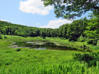 The trail from Iron Wheel Junction to Junkyard Junction is about 1.6 miles and it is all uphill gaining 465 feet. I was still fresh and Sheila was running well ahead of me. I would have liked to have another human hiking partner but I had a myriad of things to think about. At 10:30 AM we were at Junkyard Junction where we turned left to head toward Quick Lake. Sheila had already turned right on the Flynn Trail and when I called her back she gave me a strange look. This was new territory for her and I had not been out this part of the trail in over 5 years. The hiking trail is criss-crossed by snowmobile trails and in some places they run together for a distance. I wanted to make sure I stayed on the Quick Lake trail all the way to Quick Lake. After I reached the lean-to, I would make a decision about the return route. Over the next 1.1 miles the trail rolled up and down and was not crossed by any other trails. The trail was mostly covered by trees and I did not have to deal with too many wet ferns. We came to CoyoTe Junction and I checked the Avenza app on my iPhone as the trail and the junction was not well marked. I had noticed all along this part of the trail that the markers were few and far between and they were old. This trail is used expensively by snowmobilers but not by hikers. We turned to the right at Coyote Junction and followed the Quick Lake Trail for .6 miles to Bobcat Junction. This part of the trail was more open and my shoes became soaked from the wet grass and ferns. This section of trail also rolled and had a few interesting rock ledges. I noticed that an ATV had been through on the trails and had matted down some of the ferns and grasses making the walk easier. I stopped in one spot to take a few shots of the rock ledges and the trail. When we arrived at Bobcat Junction the snowmobile trail went off to the right but we continued straight ahead for about a mile on the Quick Lake Trail heading for Flat Rock Junction. Over this section of trail we began to descend losing 260 feet and I knew we would have to climb back up the trail to get back to the car. This part of the trail is not used as much by snowmobiles and the ATV had followed the snowmobile trail. It was harder to wade through the ferns and grass and it was much wetter. Sheila seemed to enjoy if as she would disappear through the ferns and reappear with a ruff of green ferns! Flat Rock Junction id a four-way junction as the snowmobile crosses the hiking trail. I knew the snowmobile trail to the left was the quickest way to Quick Lake but we walk straight across the junction to stay on the hiking trail. The trail circled to the north and finally rejoined the snowmobile trail after .9 miles. This trail was all downhill and I remembered the climb back was a killer. We walked another .4 miles downhill to the Quick Lake lean-to. The lean-to was in pretty good shape but Quick Lake is now more like Quick Pond! I took pictures of the lean-to with and without Sheila and then walked over to a viewpoint over the water. I took a few shots and returned to the lean-to. I got a drink and gave Sheila one while I ate a bar. It was 12:30 PM and the GPS indicated we had hiked 7.4 miles. I packed up and we started back toward the car.
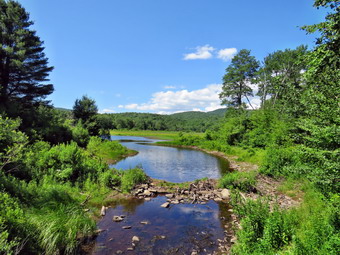 The hike so far had been pretty but without any major sites except for Quick Lake. I was actually getting a little bored with seeing a lot of green ferns! I decided to try hiking back on the snowmobile trails for some variety even though the hiking and snowmobile trails do overlap. We hiked the .4 miles back to where the trails split and I stayed right on the snowmobile trail back to Flat Rock Junction. This turned out to be a little more than half the distance of the hiking trail but the elevation gain was the same resulting in a steeper ascent. The grade was less than 10% but I have to admit I was a little tired at this point. I was also worried about blisters and a pain in my right knee. At Flat Rock Junction we retraced our route out by continuing through Bobcat Junction to Coyote Junction on the Quick Lake Trail. Although out and back hikes are my least favorite, the familiarity of the trail was reassuring. At Coyote Junction we turned right to follow the snowmobile trail first east and then south for 1.25 miles losing 400 feet. I had been on this trail before but it had been a long time and I kept thinking we were farther along than we actually were! At 11 miles into the hike the trail turned east and then south as we climbed 270 feet to the highest point on that section. The climb wasn't steep or long but I was glad when we were at the top as I knew the rest of the trip was downhill or flat. I noticed that when Sheila got too far ahead of me she would lay down in the shade. I was a little worried but she always hopped right up and ran off down the trail. I realized she was just being smart. We started to descend and the trail turned east. After .7 miles I looked up to see that we had merged with the Quick Lake Trail just north of Iron Wheel junction. I could feel that my feet had swollen some and were drenched but I knew how far we had to hike and the trail was very familiar. We turned right at Iron Wheel junction and hiked downhill to the spruce tunnel where we recrossed the stream. We kept up a good pace and soon were passing by the junction with the Big Rock Trail. When we crossed the bridge at Frick Pond, I looked at the scene and had to stop to take a few pictures. After packing up, we walked up the hill to Gravestone Junction and then continued on the trail back to the car. The parking lot was empty when we arrived at 3:45 PM. We had hiked 14.3 miles in 6.5 hours with less than 15 minutes of stopped time. Our overall speed was just over 2 mph and I was surprised that the elevation gain was 2200 feet. I was tired but I still could have pushed a few more miles especially with dry feet!
![]()
![]()
![]()
![]() On Monday, July 9th, I planned to take a longer hike somewhere but had not developed any specific plans. My brother-in-law, Jeff, contacted me Sunday night to see if I wanted to hike in the afternoon and I agreed. We decided to meet on Route 206 between Roscoe and Downsville and hike some route involving the trails around Campbell Mountain and Trout Pond. Our appointed meeting time was 12:30 PM so I ha plenty of time to do a few chores around the house before heading out. As I began to get ready around 11:00 AM I noted that the temperature had just entered the low 70's so I got dressed in a short-sleeved crew top with a short-sleeved baselayer. I put on a pair of RailRiders hiking pants which are expensive but last a long time and have features like deep pockets and a generous cut which I really like. The pants have Velcro closures at the ankles which I hoped would mean I did not need gaiters to keep the ticks out. I decided to wear my Keen Glarus hiking boots which are my "go to" hiking boots although I had recently purchased a pair of Keen Targhee II boots. I packed only one bottle of water and loaded my gear into my pack under the watchful eye of Sheila who is always near but not too near to be considered under foot. We finally pulled out of Livingston Manor just after 11:45 AM when the temperature was still in the low 70's. I drove west and north on Route 17 to exit 94 for Roscoe. From here I drove north toward Downsville of Route 206. After passing over the top of Brock Mountain, I began watching for the place where the trail crosses the road just down the hill from Jug Tavern Road. I pulled into the small parking area to wait for Jeff. I was early so I had to wait a little while for him to arrive. When he did pull in, we talked briefly and decided to drive to Trout Pond and hike from there back to Route 206. Jeff got his gear in my car and sat in the front seat. I was concerned that Sheila might object but she greeted Jeff warmly as one of the "pack". I drove back toward Roscoe on Route 206 and turned right on Morton Hill Road just before the county line. As luck would have it, the Town of Colchester had just oiled and chipped the road but I drove slowly and did not hear too many stones hit the car. At Russell Brook Road I decided to drive down the road to the lower parking area. My new Mitsubishi Eclipse Cross seemed to handle the rough road and we were soon parked in the lower lot. There was only one pickup truck parked as we got ready to hike. I set my GPS and we were off at 12:40 PM. We walked down the wide woods road to the stream and crossed over on the bridge. As we passed the Japanese knotweed I pointed out the work I had done cutting it back away from the trail. At the first trail junction we continued straight ahead toward Trout Pond. We both remarked that it was a very pleasant day with warm but dry air. The walk to the pond seemed to go quickly as we conversed on many topics. As we approached the pond, we could hear voices so I put Sheila on her leash. We stopped at the "beach" at the outlet end of the pond. I took a few pictures although the scene was not remarkable. Even though there were a few other people near the spillway, I let Sheila off her leash so that she could swim and retrieve a stick. After a few minutes, we continued our hike by walking back to the main trail.
On Monday, July 9th, I planned to take a longer hike somewhere but had not developed any specific plans. My brother-in-law, Jeff, contacted me Sunday night to see if I wanted to hike in the afternoon and I agreed. We decided to meet on Route 206 between Roscoe and Downsville and hike some route involving the trails around Campbell Mountain and Trout Pond. Our appointed meeting time was 12:30 PM so I ha plenty of time to do a few chores around the house before heading out. As I began to get ready around 11:00 AM I noted that the temperature had just entered the low 70's so I got dressed in a short-sleeved crew top with a short-sleeved baselayer. I put on a pair of RailRiders hiking pants which are expensive but last a long time and have features like deep pockets and a generous cut which I really like. The pants have Velcro closures at the ankles which I hoped would mean I did not need gaiters to keep the ticks out. I decided to wear my Keen Glarus hiking boots which are my "go to" hiking boots although I had recently purchased a pair of Keen Targhee II boots. I packed only one bottle of water and loaded my gear into my pack under the watchful eye of Sheila who is always near but not too near to be considered under foot. We finally pulled out of Livingston Manor just after 11:45 AM when the temperature was still in the low 70's. I drove west and north on Route 17 to exit 94 for Roscoe. From here I drove north toward Downsville of Route 206. After passing over the top of Brock Mountain, I began watching for the place where the trail crosses the road just down the hill from Jug Tavern Road. I pulled into the small parking area to wait for Jeff. I was early so I had to wait a little while for him to arrive. When he did pull in, we talked briefly and decided to drive to Trout Pond and hike from there back to Route 206. Jeff got his gear in my car and sat in the front seat. I was concerned that Sheila might object but she greeted Jeff warmly as one of the "pack". I drove back toward Roscoe on Route 206 and turned right on Morton Hill Road just before the county line. As luck would have it, the Town of Colchester had just oiled and chipped the road but I drove slowly and did not hear too many stones hit the car. At Russell Brook Road I decided to drive down the road to the lower parking area. My new Mitsubishi Eclipse Cross seemed to handle the rough road and we were soon parked in the lower lot. There was only one pickup truck parked as we got ready to hike. I set my GPS and we were off at 12:40 PM. We walked down the wide woods road to the stream and crossed over on the bridge. As we passed the Japanese knotweed I pointed out the work I had done cutting it back away from the trail. At the first trail junction we continued straight ahead toward Trout Pond. We both remarked that it was a very pleasant day with warm but dry air. The walk to the pond seemed to go quickly as we conversed on many topics. As we approached the pond, we could hear voices so I put Sheila on her leash. We stopped at the "beach" at the outlet end of the pond. I took a few pictures although the scene was not remarkable. Even though there were a few other people near the spillway, I let Sheila off her leash so that she could swim and retrieve a stick. After a few minutes, we continued our hike by walking back to the main trail.
The trail along the east side of the pond was damp in places and we could see the tracks of a motorized vehicle. It seemed larger than an ATV but we could never determine the exact type or purpose. As we approached the lean-to, I stopped to remove a tiny sharp stone from my right boot. It is surprising how annoying this can be! While stopped, we heard a high-pitched noise in the brush. It was most probably a bird but I began to think baby bear! The noise moved on and so did we as we stayed right at the lean-to the start over the hill to Campbell Brook Road. Over the next .8 miles we headed almost due north gaining 440 feet. This is about a 10% grade which is not extreme but we were certainly aware that we were ascending. Our conversations continued on a variety of topics which made the hiking seem to go faster. From the top of the hill we began a descent of 410 feet over .8 miles making the hill almost symmetrical except for the twists and turns on the way down. We made a short ascent to Campbell Brook Road at 3.2 miles into the hike. It was 2:30 PM and I began to realize the hike was a little longer than I thought and we were hiking a little slower than I had planned. I worried that Jeff would have a hard time making his 5:00 PM meeting in Delhi if we completed the entire hike. We turned left on Campbell Brook Road and walk a few hundred feet west to the point where the trail again entered the woods. This section of trail is not used very much so the blazing and maintenance leave something to be desired. We began to hiked north and then northwest on an ascent of 335 feet in .5 miles to the summit of an unnamed hill. We agreed that completing the hike might take a little too long. I took a chance and called my wife and was happy to be able to contact her. She agreed to meet us where the trail intersected Campbell Brook Road! Jeff and I began to descend the hill heading toward our pickup point. Somewhere along the way Sheila came loping along and Jeff noticed she was limping and favoring her right from foot. I was fearing that she had injured her leg or cut herself badly. I inspected her front left paw and found a large thorn over and inch long embedded in between her pads. I had to give it a firm tug to get it out. After I removed it, Sheila was back to running around without any after effects. She is a tough dog! We continued to descend the trail as it headed northwest and then east and northeast. We were having trouble finding blazes and there were many areas with high grass, briars and nettles. The trail was pretty obvious and at 4.7 miles we crossed Campbell Brook on a bridge and began to ascend. I was pretty sure the ascent on a grass woods road was simply the approach to Campbell Mountain Road so I began to call out Cindy's name. I didn't really expect her to answer but after a few calls she did! Soon we could see the car and Cindy and Sheila went running ahead to greet her. We arrived at the car at 3:30 PM after hiking 5.1 miles in 2 hours and 50 minutes with an elevation gain of 1320 feet. Our average speed was a little under 2 mph which was okay for the rolling terrain. Jeff said he would contact me soon to try another hike. We agreed that we would like to actually hike over Campbell Mountain sometime!
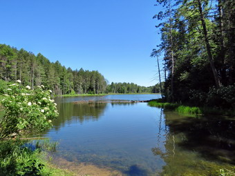
![]()
![]()
![]()
![]()
![]() On Saturday, July 7th, I asked Cindy if she wanted to go for a walk. She said "Yes" and suggested we go for a hike that was a little farther from home. I agreed but turned down the suggestion of Thacher Park as I knew it would be packed on the weekend. I suggested Morgan Hill State Forest and she agreed. I wanted to hike the eastern loop that goes by Shackham Pond and uses some dirt and gravel roads. Fortunately the heat wave had broken and the weather forecast was for partly sunny skies with highs only in the high 70's and much lower humidity. In fact, the temperature at 8:00 AM was 65 degrees and it seemed very comfortable. I remembered the directions to Morgan Hill and knew that the 130 mile trip would take a little over 2 hours. I wanted to get an early start but we seemed to be in slow motion as we ate breakfast and got ready. I got dressed in a short-sleeved crew top with a short-sleeved baselayer. I put on a pair of RailRiders hiking pants which are expensive but last along time and have features like deep pockets and a generous cut which I really like. The pants have Velcro closures at the ankles which I hoped would mean I did not need gaiters. The ticks have been very numerous so far this season especially farther south. I decided to wear my Keen Glarus hiking boots which are my "go to" hiking boots. I packed two bottles of water and loaded my gear into my pack under the watchful eye of Sheila who is always near but not too near to be considered under foot. We finally pulled out of Livingston Manor just after 9:00 AM when the temperature was still in the mid 60's. The trip is pretty straightforward but I have not driven this far to hike in some time. I drove west and north on Route 17 to Binghamton and then north on I81 to exit 11. Route 13 north took us about 10 miles to Route 91 in Truxton where I turned left. After about 3.6 miles, I turned right on Shackham Road in Morgan Hill State Forest. After about .5 miles, there is a pulloff at the side of the road where North Country Trail crosses but I knew this was the lower crossing so I continued to drive until I saw a large parking area on the right and a state forest sign on the left. I drove a little farther up the road and within .5 miles found another pulloff on the right and signs for the North Country Trail. There were already a few cars parked at the side of the road. The North Country National Scenic Trail stretches approximately 4,600 miles from Crown Point on Lake Champlain in eastern New York to Lake Sakakawea State Park in central North Dakota in the United States. I parked the car at 11:05 AM and we were on the trail by 11:15 AM. We headed east on the NCT and it was only a short distance to the shores of Shackham Pond. The pond was pretty and was surrounded by very green trees. The water was completely still and the trees wand sky were reflected on the surface of the water. The only problem was that the skies had no puffy white clouds! I took some pictures before we headed back to the main trail. Within a few hundred feet, the trail split and I stayed to the left to walk over a small hill and down to the shore. In a clearing we found a few gravestones from the Hodgson family who once owned the property. I got my camera out and took a few more pictures. I noticed some large birds on the other side of the pond and zoomed in on them. There were at least four pairs of Great Blue Heron in very large nests. I took as many pictures as I could but I had to sit to steady the camera at the extreme magnification. After taking my pictures, I put the camera back in my packed and we headed back to the main trail. We passed across the top of the dam that creates the pond. I again dropped my pack and took some more pictures from a different angle.
On Saturday, July 7th, I asked Cindy if she wanted to go for a walk. She said "Yes" and suggested we go for a hike that was a little farther from home. I agreed but turned down the suggestion of Thacher Park as I knew it would be packed on the weekend. I suggested Morgan Hill State Forest and she agreed. I wanted to hike the eastern loop that goes by Shackham Pond and uses some dirt and gravel roads. Fortunately the heat wave had broken and the weather forecast was for partly sunny skies with highs only in the high 70's and much lower humidity. In fact, the temperature at 8:00 AM was 65 degrees and it seemed very comfortable. I remembered the directions to Morgan Hill and knew that the 130 mile trip would take a little over 2 hours. I wanted to get an early start but we seemed to be in slow motion as we ate breakfast and got ready. I got dressed in a short-sleeved crew top with a short-sleeved baselayer. I put on a pair of RailRiders hiking pants which are expensive but last along time and have features like deep pockets and a generous cut which I really like. The pants have Velcro closures at the ankles which I hoped would mean I did not need gaiters. The ticks have been very numerous so far this season especially farther south. I decided to wear my Keen Glarus hiking boots which are my "go to" hiking boots. I packed two bottles of water and loaded my gear into my pack under the watchful eye of Sheila who is always near but not too near to be considered under foot. We finally pulled out of Livingston Manor just after 9:00 AM when the temperature was still in the mid 60's. The trip is pretty straightforward but I have not driven this far to hike in some time. I drove west and north on Route 17 to Binghamton and then north on I81 to exit 11. Route 13 north took us about 10 miles to Route 91 in Truxton where I turned left. After about 3.6 miles, I turned right on Shackham Road in Morgan Hill State Forest. After about .5 miles, there is a pulloff at the side of the road where North Country Trail crosses but I knew this was the lower crossing so I continued to drive until I saw a large parking area on the right and a state forest sign on the left. I drove a little farther up the road and within .5 miles found another pulloff on the right and signs for the North Country Trail. There were already a few cars parked at the side of the road. The North Country National Scenic Trail stretches approximately 4,600 miles from Crown Point on Lake Champlain in eastern New York to Lake Sakakawea State Park in central North Dakota in the United States. I parked the car at 11:05 AM and we were on the trail by 11:15 AM. We headed east on the NCT and it was only a short distance to the shores of Shackham Pond. The pond was pretty and was surrounded by very green trees. The water was completely still and the trees wand sky were reflected on the surface of the water. The only problem was that the skies had no puffy white clouds! I took some pictures before we headed back to the main trail. Within a few hundred feet, the trail split and I stayed to the left to walk over a small hill and down to the shore. In a clearing we found a few gravestones from the Hodgson family who once owned the property. I got my camera out and took a few more pictures. I noticed some large birds on the other side of the pond and zoomed in on them. There were at least four pairs of Great Blue Heron in very large nests. I took as many pictures as I could but I had to sit to steady the camera at the extreme magnification. After taking my pictures, I put the camera back in my packed and we headed back to the main trail. We passed across the top of the dam that creates the pond. I again dropped my pack and took some more pictures from a different angle.
 We resumed our hike heading north through mostly hardwood forest. At about .7 miles we crossed a well-maintained dirt road and entered an evergreen forest. We passed by the FLT/NCNST register and continued on the trail. The trail paralleled a small stream for some time and was damp and muddy in places. In this area the trail was almost flat with only a few bumps. We passed by several woods roads and at 1.9 miles the trail again crossed a road before entering the woods again. I wasn't sure if this was Morgan Hill Road where I wanted to turn right and I had not brought a map. The FLT continued straight ahead into the woods but I knew it silly continued east and we wanted to head south. We turned right on the dirt road which became Morgan Hill Road at 2.2 miles after a gate which was open and familiar from one of my previous hikes. The road forked after this but I knew that we should stay to the left. Walking on the road may not be excited but it is easy and the first part of it seemed pretty secluded. It was almost like walking a woods road. The day was beginning to get warmer especially since we were now walking in and out of the sunlight. A nice breeze helped keep us cool and the humidity still was low. From previous trips I knew that the hike on the road would be pretty long so I settled in and started to think about the beauty around me. At 4.2 miles Eaton Hill Road came in from the left and I knew it would be only a half mile or so until the trail would appear on the right. We began to hear voices in the woods and then spotted some mountain bikers riding their trails. Two of the bikers came out into the road and said "Hello"> They asked if we had seen a parking area with a green Subaru farther down the road. I told them we had seen the parking area but there was no car. Cindy and I both got the impression they were looking for the place they had parked their own car! Just to make sure we didn't go to far and miss the turn onto the trail, I checked my own website which had some great instructions! We continued and the NCT crossed within a short distance. We turned right into the forest and headed almost due east along a tributary of Shackham Brook. We stopped to get a drink and a snack and two hikers with dogs on leashes chose to pass us. I knew that we were probably faster than they were. We started hiking and quickly caught up to the others but I stayed a little behind to avoid interactions with their dogs. They were very courteous and stepped off the trail to allow us to pass and we never saw them again. We navigated a muddy section of trail on our way to a beautiful ravine. At 5.2 miles we walked down the trail into the ravine. The trail crossed the brook here but I could see a small waterfall just upstream but there was not enough water to bother fisting it this time.
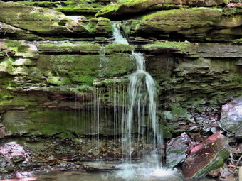 The trail almost immediately met a woods road and followed it for some distance until the point where the trail turned to the right off the woods road and headed down. We started to walk parallel to the brook and I noticed several small waterfalls. At one point I saw a larger cascade and walked to the edge of the high bank. There were too many trees and too little water to make taking pictures worthwhile. We continued to walk on parallel to the brook until 6.1 miles where there was another nice waterfall to the left of the trail. Although it wasn't that high and there wasn't much water, I stopped and took a few pictures before continuing on the trail toward Shackham Road. We met a few more people on the trail coming from the lower parking lot on the road. One group had a dog which was on a leash! A nice footbridge crossed the stream and as I looked down I saw that the streambed was solid rock. Shackham Brook in this area flows for at least several hundred feet over solid bedrock. I took a few pictures and then posed Sheila on the bridge for a few more shots. We found a way around a very muddy patch on the other side of the trail. From here it was a short walk to Shackham Road 6.65 miles into the hike at 2:35 PM. The car was still 1.5 miles up the road which is paved and mostly uphill! I would have continued on to Jones Hill and Tinker Falls but I knew Cindy was tired. Also, the falls are usually a disappointment unless there was been a recent, hard rainfall. I stowed my poles in my pack and out Sheila on her leash. I was still feeling very good as Sheila and I set off heading north on Shackham Road. At one point I looked back and saw that I needed to slow down as we were outpacing Cindy. We arrived back at the car at 3:05 PM after hiking 8 miles with an elevation gain of 1075 feet. The temperature was now 78 degrees but the black interior of my new car was considerably warmer. Despite over 30 minutes of stops we had averaged over 2 mph which I considered good!
![]()
![]()
![]()
![]() On Thursday, July 5th I knew I needed to get out in the morning since showers were forecast for the afternoon. I decided to go to Frick Pond to cut some blowdowns I was nursing a blister on my foot and didn't want to hike too far. I slept in a little late but when I got up at 9:00 AM it was already in the high 70's and the humidity seemed oppressive! I was hoping the heat wave would break but today was not the day. I got dressed in a short-sleeved crew top with a short-sleeved baselayer. I put on a pair of RailRiders hiking pants which are expensive but last along time and have features like deep pockets and a generous cut which I really like. The pants have Velcro closures at the ankles which I hoped would mean I did not need gaiters. The ticks have been very numerous so far this season especially farther south. I decided to wear my Keen Glarus hiking boots which are my "go to" hiking boots. I packed two bottles of water and loaded my gear into my pack under the watchful eye of Sheila who is always near but not too near to be considered under foot. I packed both my Silky Katanaboy and Sugowaza saws and brought along my Fiskars X27 axe. The Sugowaza is a 17" curved and fixed blade which fits in a scabbard. The KatanaBoy is almost two feet long and is a folding saw with a nylon carrier. Both are remarkably sharp and can take care of some large tree trunks. I brought along my light Fiskars axe leaving the full-sized Council Tools Velvicut at home. The latter has a 4 pound head so I don't bring it unless I don't have to carry it very far. I left my poles at home knowing I would be carrying the tools the whole way to do trail work. I got my gear in the car and Sheila in the backseat and left Livingston Manor around 9:45 AM. I drove out the DeBruce Road but as I made the turn there was a line of traffic behind a truck painting lines on the road. I hoped they would stop or let the traffic by after passing under the Quickway but they continued out the DeBruce Road in the direction I was going. I knew I didn't want to follow them so I turned around and drove back home. My new plan was to hike on Round Top see inspect the condition of the trails. I parked the car which distressed Sheila greatly especially when I went inside to drop my pack and tools. I came back out quickly and rescued Sheila from the backseat. I put her on her leash and she pulled me out the driveway knowing exactly where we were going. I decided we could do some figure 8's just for the exercise and to take a look at the condition of the trails. My aim was to do four figure 8's which was what I was doing before the snow fell for the winter. Sheila was happy to get out as we headed down the driveway and across the street at about 10:10 AM. We crossed the street with Sheila on her leash and walked to the back of the church. We were met by a very pretty dark brown male dog who was running around without an owner in site. He seemed friendly but was being an annoyance. We began the ascent of the steepest hill behind the church with the other dog following closely behind despite my encouragement for him to "Go home!" I could hear someone calling him but the dog was paying no attention and the person calling was too lazy to run after him. The hill is short but really gets the circulation pumping and is the steepest and longest climb on the "trail". Sheila helped me along by pulling me up the hill.
On Thursday, July 5th I knew I needed to get out in the morning since showers were forecast for the afternoon. I decided to go to Frick Pond to cut some blowdowns I was nursing a blister on my foot and didn't want to hike too far. I slept in a little late but when I got up at 9:00 AM it was already in the high 70's and the humidity seemed oppressive! I was hoping the heat wave would break but today was not the day. I got dressed in a short-sleeved crew top with a short-sleeved baselayer. I put on a pair of RailRiders hiking pants which are expensive but last along time and have features like deep pockets and a generous cut which I really like. The pants have Velcro closures at the ankles which I hoped would mean I did not need gaiters. The ticks have been very numerous so far this season especially farther south. I decided to wear my Keen Glarus hiking boots which are my "go to" hiking boots. I packed two bottles of water and loaded my gear into my pack under the watchful eye of Sheila who is always near but not too near to be considered under foot. I packed both my Silky Katanaboy and Sugowaza saws and brought along my Fiskars X27 axe. The Sugowaza is a 17" curved and fixed blade which fits in a scabbard. The KatanaBoy is almost two feet long and is a folding saw with a nylon carrier. Both are remarkably sharp and can take care of some large tree trunks. I brought along my light Fiskars axe leaving the full-sized Council Tools Velvicut at home. The latter has a 4 pound head so I don't bring it unless I don't have to carry it very far. I left my poles at home knowing I would be carrying the tools the whole way to do trail work. I got my gear in the car and Sheila in the backseat and left Livingston Manor around 9:45 AM. I drove out the DeBruce Road but as I made the turn there was a line of traffic behind a truck painting lines on the road. I hoped they would stop or let the traffic by after passing under the Quickway but they continued out the DeBruce Road in the direction I was going. I knew I didn't want to follow them so I turned around and drove back home. My new plan was to hike on Round Top see inspect the condition of the trails. I parked the car which distressed Sheila greatly especially when I went inside to drop my pack and tools. I came back out quickly and rescued Sheila from the backseat. I put her on her leash and she pulled me out the driveway knowing exactly where we were going. I decided we could do some figure 8's just for the exercise and to take a look at the condition of the trails. My aim was to do four figure 8's which was what I was doing before the snow fell for the winter. Sheila was happy to get out as we headed down the driveway and across the street at about 10:10 AM. We crossed the street with Sheila on her leash and walked to the back of the church. We were met by a very pretty dark brown male dog who was running around without an owner in site. He seemed friendly but was being an annoyance. We began the ascent of the steepest hill behind the church with the other dog following closely behind despite my encouragement for him to "Go home!" I could hear someone calling him but the dog was paying no attention and the person calling was too lazy to run after him. The hill is short but really gets the circulation pumping and is the steepest and longest climb on the "trail". Sheila helped me along by pulling me up the hill.
When we got to the top of the hill, we started out on the trail by turning left at the trailhead. As we entered the trees, the other dog continued to follow us so I left Sheila on her leash and continued to yell at the dog. At the first trail junction we continued straight ahead to walk the steeper path to the viewpoint and the other dog finally lost interest and disappeared. I let Sheila off her leash as we climbed the hill. At the lookout I noted that there was no garbage and everything was in order. From the upper part of the lookout the trees block most of the view despite the efforts of the Town of Rockland sawyer crew to cut down some trees. I walked down to the lower lookout and found only one tree blocking the view. The problem is that getting to the lower lookout is a little difficult for the average person. We followed the trail to the right and started the gentle climb through the woods. The trail was really beautiful and clear of most branches. The trail bed was lined with very green ferns and pretty clearly delineated. When we reached the next trail junction, we stayed to the right to follow the lower trail around the base of Round Top to the next junction. There were a few branches encroaching on the trail and I made a note to rerun in the next few days to do some lopping. At the next junction we turned left and started up to the summit of Round Top on the steeper blue trail. There were several places where lopping was needed especially near the top. We walked across the summit of Round Top where a few more bushes needed some trimming and down the other side which is also a little steep. When we got to the yellow trail, we turned left to follow it to the second trail junction. This time we turned right and followed the yellow trail back to the very first trail junction. Along the way were a few branches hanging down unto the trail. At the trail junction we turned around and retraced our steps taking the more gentle path this time. When the yellow trail turned left, we followed it to the next trail junction were we turned right and headed up the blue trail to the summit. We walked over the top and down the other side to the yellow trail again. We turned right and followed the trail along the base of Round Top. Where the yellow trail turned left, we followed it to the left and down to the lookout. From the lookout we walked down hill to the first trail junction. I was pretty tired at this point and I am sure the high humidity had contributed to this feeling. Since my goal was to do four figure 8's we turned around to start back up the hill. It takes us about 20 minutes to do one complete figure 8 from the first trail junction. We repeated the first figure 8's with me taking time to think about various topics. By the time we were into this third figure 8, I was feeling better and ready for the final one! Sheila was well-behaved and stayed with me most of the time. After finishing the last figure 8, we walked out to the trailhead. I put Sheila on her leash and we walked down the cemetery hill and across the field to our driveway. It was 11:55 AM and we had hiked about 3.3 miles in 1 hour and 45 minutes. It must have been a good workout as I was tired. When I got home, I looked at the grass and decided I wanted to mow it before the rains came and it grew any more. I also wanted to start my Stihl string trimmer which I had not used since the previous fall. I was surprised that I remembered exactly how to use it and that it started with no problems!
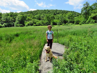
![]()
![]()
![]()
![]()
![]() On Tuesday, July 3rd, I wanted to get in a hike in the morning since thunderstorms were predicted for the afternoon. The forecast for the rest of the week also called for the possibility storms which I knew might limit my hiking. I decided that I needed a hike close to home but wanted to get away from the "usual places" that I frequent! I thought about a list of options and settled on a hike from Alder Lake to the lookout over Beecher Lake. This viewpoint had been recently cut out to restore the view of Beecher Lake that had been blocked by the trees that had grown up over the years. My grandson Bryce would be hiking with me and I wasn't sure that we could make the 8.5 mile round trip in time to avoid the afternoon storms. When I woke up at 8:00 AM it was already in the low 70's with high humidity. I knew this also might limit the distance we would want to hike. Bryce arrived shortly after 9:00 AM. I got dressed in a short-sleeved crew top with a short-sleeved baselayer. I put on a pair of RailRiders hiking pants which are expensive but last along time and have features like deep pockets and a generous cut which I really like. The pants have Velcro closures at the ankles which I hoped would mean I did not need gaiters. The ticks have been very numerous so far this season especially farther south. I decided to wear my Keen Glarus hiking boots which are my "go to" hiking boots. I packed two bottles of water and Bryce brought his own Camelbak. I got my gear and Sheila in the car and headed up the Beaverkill Road somewhere around 9:45 AM. I headed toward Turnwood and Alder Creek Road where I made a left and drove to the Alder Lake parking lot. I parked at 10:10 AM started our hike almost immediately. There were a few other vehicles in the lot by the lake and we could hear machinery working near the dam. The temperature was 78 degrees with a slight breeze but relatively high humidity. The skies were blue with puffy white clouds. We headed down to the "lawn" passing by the stone foundations which marked the last remnants of the Coykendall Mansion. Bryce asked about them and I told him the story of the mansion and its final demise. A truck was parked by the ruins and another was positioned in the lawn by the dam. The lawn had been mowed and the truck by the dam had DEC marking although I could not see exactly what they were doing. We walked toward the trail around the left side of the lake but when I saw the clouds over the lake I decided to stop and take some pictures. Sheila immediately jumped into the water and I took some picture of her and more pictures of the lake including Millbrook Ridge and Cradle Rick Ridge. I pointed out all the features to Bryce. We headed over to the trail with Sheila on her leash and as we walked along the trail I kept an eye out for the occupants of the vehicles in the parking area. Brush and branches were beginning to grow into the trail and they needed some pruning. Sheila was happy to be out and so was Bryce. as we passed the last campsite, I noticed it was occupied and a pit bull came out to greet us. The owner claimed the dog was friendly and I told him mine was sometimes friendly. He controlled his dog and we passed by the campsite.
On Tuesday, July 3rd, I wanted to get in a hike in the morning since thunderstorms were predicted for the afternoon. The forecast for the rest of the week also called for the possibility storms which I knew might limit my hiking. I decided that I needed a hike close to home but wanted to get away from the "usual places" that I frequent! I thought about a list of options and settled on a hike from Alder Lake to the lookout over Beecher Lake. This viewpoint had been recently cut out to restore the view of Beecher Lake that had been blocked by the trees that had grown up over the years. My grandson Bryce would be hiking with me and I wasn't sure that we could make the 8.5 mile round trip in time to avoid the afternoon storms. When I woke up at 8:00 AM it was already in the low 70's with high humidity. I knew this also might limit the distance we would want to hike. Bryce arrived shortly after 9:00 AM. I got dressed in a short-sleeved crew top with a short-sleeved baselayer. I put on a pair of RailRiders hiking pants which are expensive but last along time and have features like deep pockets and a generous cut which I really like. The pants have Velcro closures at the ankles which I hoped would mean I did not need gaiters. The ticks have been very numerous so far this season especially farther south. I decided to wear my Keen Glarus hiking boots which are my "go to" hiking boots. I packed two bottles of water and Bryce brought his own Camelbak. I got my gear and Sheila in the car and headed up the Beaverkill Road somewhere around 9:45 AM. I headed toward Turnwood and Alder Creek Road where I made a left and drove to the Alder Lake parking lot. I parked at 10:10 AM started our hike almost immediately. There were a few other vehicles in the lot by the lake and we could hear machinery working near the dam. The temperature was 78 degrees with a slight breeze but relatively high humidity. The skies were blue with puffy white clouds. We headed down to the "lawn" passing by the stone foundations which marked the last remnants of the Coykendall Mansion. Bryce asked about them and I told him the story of the mansion and its final demise. A truck was parked by the ruins and another was positioned in the lawn by the dam. The lawn had been mowed and the truck by the dam had DEC marking although I could not see exactly what they were doing. We walked toward the trail around the left side of the lake but when I saw the clouds over the lake I decided to stop and take some pictures. Sheila immediately jumped into the water and I took some picture of her and more pictures of the lake including Millbrook Ridge and Cradle Rick Ridge. I pointed out all the features to Bryce. We headed over to the trail with Sheila on her leash and as we walked along the trail I kept an eye out for the occupants of the vehicles in the parking area. Brush and branches were beginning to grow into the trail and they needed some pruning. Sheila was happy to be out and so was Bryce. as we passed the last campsite, I noticed it was occupied and a pit bull came out to greet us. The owner claimed the dog was friendly and I told him mine was sometimes friendly. He controlled his dog and we passed by the campsite.
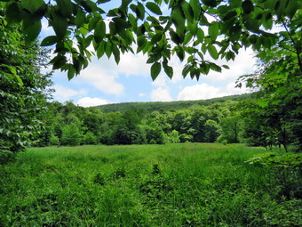 As we crossed the bridges on the trail, we both noticed the beaver dams that had water backed up so much that the trail was plodding. I stopped to take a few pictures before we continued on the trail toward the junction with the Millbrook Ridge Trail. As we approached the trail junction, we met two women with three dogs.All the dogs were on leashes but one women had trouble controlling two of the dogs. At about .8 miles we turned left to head toward the lean-to on the Millbrook Ridge Trail. As we turned, I noticed that the next bridge had been cleared of a large tree that had fallen across it.
The trail was wet and muddy in many places and there were both old and new blowdowns to contend with. Some of the blowdowns had been cut but whoever did the cutting left what they cut in the trail! Others were cut in several, places but the job was left incomplete. I was almost sorry I did not have my saws but decided this was work for another day. I thought it would be nice to find out who the maintainer is for the trail and offer to help. For the next 1.5 miles the trail climbs and then levels off several times. The elevation gain is several hundred feet but the grade is never more than 12% and averages around 6%. There isn't too much to see along the way but this day was very pleasant. I enjoyed the sounds and sights of Alder Creek as it flows parallel to the trail much of the way. In one spot there was a large beaver dam on the left. Hiking with Bryce is always a pleasure. He will begging into second grade in the fall but talking to him is more like talking to a much older person. We discussed a few Bible stories which is his favorite topic. On this trip I taught him abut exponents and square roots. We also discussed history and science topics. Soon we arrived at the Beaver Meadow lean-to. We walked down to the lean-to and I dropped my pack and got out the camera. I noticed that the privy was now completely torn apart by thoughtless campers looking for some firewood. One person starts the vandalism and the rest join in! It had taken only an hour an 10 minutes to get to the beaver meadow even though we had stopped several times to clear the trail and take pictures. We walked out to the edge of the beaver meadow where there is a large flat rock and I took pictures of the very green scene. I also got a few shots of Sheila and Bryce on the rock. Sheila jumped into the stream running through the beaver meadow and came out a muddy mess! We went back to the lean-to and got a drink and shared a bar. I decided we would hike a little more so that we could visit the next beaver meadow and perhaps walk to the top of Millbrook Ridge. We both agreed that the longer hike to the lookout would have to be for another day. We weren't too tired but the heat was draining our energy and I wanted to make sure we were back before any thunderstorms rolled in.
As we crossed the bridges on the trail, we both noticed the beaver dams that had water backed up so much that the trail was plodding. I stopped to take a few pictures before we continued on the trail toward the junction with the Millbrook Ridge Trail. As we approached the trail junction, we met two women with three dogs.All the dogs were on leashes but one women had trouble controlling two of the dogs. At about .8 miles we turned left to head toward the lean-to on the Millbrook Ridge Trail. As we turned, I noticed that the next bridge had been cleared of a large tree that had fallen across it.
The trail was wet and muddy in many places and there were both old and new blowdowns to contend with. Some of the blowdowns had been cut but whoever did the cutting left what they cut in the trail! Others were cut in several, places but the job was left incomplete. I was almost sorry I did not have my saws but decided this was work for another day. I thought it would be nice to find out who the maintainer is for the trail and offer to help. For the next 1.5 miles the trail climbs and then levels off several times. The elevation gain is several hundred feet but the grade is never more than 12% and averages around 6%. There isn't too much to see along the way but this day was very pleasant. I enjoyed the sounds and sights of Alder Creek as it flows parallel to the trail much of the way. In one spot there was a large beaver dam on the left. Hiking with Bryce is always a pleasure. He will begging into second grade in the fall but talking to him is more like talking to a much older person. We discussed a few Bible stories which is his favorite topic. On this trip I taught him abut exponents and square roots. We also discussed history and science topics. Soon we arrived at the Beaver Meadow lean-to. We walked down to the lean-to and I dropped my pack and got out the camera. I noticed that the privy was now completely torn apart by thoughtless campers looking for some firewood. One person starts the vandalism and the rest join in! It had taken only an hour an 10 minutes to get to the beaver meadow even though we had stopped several times to clear the trail and take pictures. We walked out to the edge of the beaver meadow where there is a large flat rock and I took pictures of the very green scene. I also got a few shots of Sheila and Bryce on the rock. Sheila jumped into the stream running through the beaver meadow and came out a muddy mess! We went back to the lean-to and got a drink and shared a bar. I decided we would hike a little more so that we could visit the next beaver meadow and perhaps walk to the top of Millbrook Ridge. We both agreed that the longer hike to the lookout would have to be for another day. We weren't too tired but the heat was draining our energy and I wanted to make sure we were back before any thunderstorms rolled in.
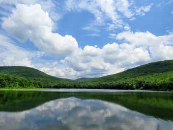 When we got to the next beaver meadow, I took some pictures before continuing on the trail toward Millbrook Ridge. We hiked another .7 miles until the trail began to climb steeply and Bryce and I began to feel it was time to turn around. I had not been on the trail in some time and it was much steeper and longer than I remembered. We did pass through some interesting areas where there were large expanses of nettles! Once we turned around, we both realized that the rerun trip would be much easier as it was almost all downhill. We did not stop on the way back and the walk went quickly. We were soon at the loop trail around Alder Lake where we turned left to complete the loop around the lake. Shortly after the turn we came to the bridge that had been damaged by a very large tree that fell across it. I had cut some of the tree off the bridge the last time I was at Alder Lake and a DEC sawyer crew had finished the job. The railings still needed to be reapplies but the rest of the bridge was in good shape. The DEC had replaced an old bridge in the same location with a new bridge that had steel ibeams to support the deck. We walked back up to the main loop trail and turned right to continue back toward the dam. The trail ascends some as it approaches the dam but the slope is gentle. I pointed out to Bryce that Cradle Rock Ridge was on our left and climbing it is an enjoyable bushwhack. We came to a deep ravine cut by a small stream. There had been a bridge across the stream but it had been destroyed by a tree falling across it and now the DEC had removed it. The stream was dry so we walked won the bank, crossed the dry streambed and then walked u the other side. I was surprised to see several new, steel ibeams on the other side! I knew this meant the DEC was going to replace the bridge which I though was a great idea. I took some pictures of the site of the bridge and the beams. We continued to walk on the trail coming out of the woods in a small clearing very near the dam. We walked up to the dam and across it. I noticed the beautiful sky and clouds and took a few more pictures before walking up the hill to the mansion. We passed by the remains of the mansion and walked to the car. We were back at 1:50 PM having covered 6.0 miles in 3 hours and 35 minutes with 25 minutes of stopped time. The total elevation gain was 970 feet.
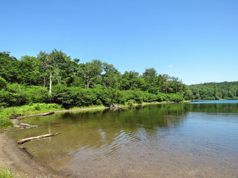
![]()
![]()
![]()
![]()
![]() On Monday, July 2nd I had decided that I wanted to go hiking despite the forecast for temperatures in the 90's with high humidity driving the heat index above 100 degrees! I thought I would start early and hike the trail from Alder Lake to the lookout over Beecher Lake. This lookout was recently cut out to allow a clear view of the lake and the Zen monastery. The hike is around 8 miles and I knew starting early would be a good idea. When the ambulance pager sounded at 4:30 AM, my plans changed. We went to Roscoe to help lift an older gentleman from the floor to his chair. When I returned home, I decided to get a little more sleep and eventually got out of bed at 9:00 AM. The temperature was around 70 degrees so I decided to go to Frick Pond and hike the longer loop around Frick and Hodge Ponds. I asked Cindy if she would like to go but she declined based on the forecast. As I began to get ready, Sheila was ready to go and stayed close so that I would not forget her. I got dressed in a short-sleeved crew top with a short-sleeved baselayer. I put on a pair of RailRiders hiking pants which are expensive but last along time and have features like deep pockets and a generous cut which I really like. The pants have Velcro closures at the ankles which I hoped would mean I did not need gaiters. The ticks have been very numerous so far this season especially farther south. I decided to wear my Keen Glarus hiking boots which are my "go to" hiking boots. I got my gear together and put Sheila in the back seat and headed out the DeBruce Road at 9:30 AM. After six miles, I turned left on Mongaup Pond Road and stayed to the left on Beech Mountain Road when it split. When we arrived at the trailhead, there were two vehicles in the smaller parking area. The temperature was 78 degrees when I set my GPS and we crossed the road at 9:45 AM to begin our hike. We quickly walked along the Flynn Trail to the woods road that was once the extension of Beech Mountain Road. We turned right on the woods road and started the long climb toward the junction with the Big Rock Trail. Along the way I picked up a few branches and threw then to the side of the trail. It seemed to me we were moving very quickly and I was feeling full of energy. At one point I looked up to see a couple walking toward us. I took Sheila by the collar and walked off the trail to allow the others to pass. As long as I was stopped I decided to get a drink and apply some insect repellant. At about 1.25 miles we came to the point where I sometimes turn off the trail to visit an interesting clearing. We continued up the trail to the Big Rock Junction at 10:25 AM after hiking 1.7 miles. The 40 minute travel time was very fast.
On Monday, July 2nd I had decided that I wanted to go hiking despite the forecast for temperatures in the 90's with high humidity driving the heat index above 100 degrees! I thought I would start early and hike the trail from Alder Lake to the lookout over Beecher Lake. This lookout was recently cut out to allow a clear view of the lake and the Zen monastery. The hike is around 8 miles and I knew starting early would be a good idea. When the ambulance pager sounded at 4:30 AM, my plans changed. We went to Roscoe to help lift an older gentleman from the floor to his chair. When I returned home, I decided to get a little more sleep and eventually got out of bed at 9:00 AM. The temperature was around 70 degrees so I decided to go to Frick Pond and hike the longer loop around Frick and Hodge Ponds. I asked Cindy if she would like to go but she declined based on the forecast. As I began to get ready, Sheila was ready to go and stayed close so that I would not forget her. I got dressed in a short-sleeved crew top with a short-sleeved baselayer. I put on a pair of RailRiders hiking pants which are expensive but last along time and have features like deep pockets and a generous cut which I really like. The pants have Velcro closures at the ankles which I hoped would mean I did not need gaiters. The ticks have been very numerous so far this season especially farther south. I decided to wear my Keen Glarus hiking boots which are my "go to" hiking boots. I got my gear together and put Sheila in the back seat and headed out the DeBruce Road at 9:30 AM. After six miles, I turned left on Mongaup Pond Road and stayed to the left on Beech Mountain Road when it split. When we arrived at the trailhead, there were two vehicles in the smaller parking area. The temperature was 78 degrees when I set my GPS and we crossed the road at 9:45 AM to begin our hike. We quickly walked along the Flynn Trail to the woods road that was once the extension of Beech Mountain Road. We turned right on the woods road and started the long climb toward the junction with the Big Rock Trail. Along the way I picked up a few branches and threw then to the side of the trail. It seemed to me we were moving very quickly and I was feeling full of energy. At one point I looked up to see a couple walking toward us. I took Sheila by the collar and walked off the trail to allow the others to pass. As long as I was stopped I decided to get a drink and apply some insect repellant. At about 1.25 miles we came to the point where I sometimes turn off the trail to visit an interesting clearing. We continued up the trail to the Big Rock Junction at 10:25 AM after hiking 1.7 miles. The 40 minute travel time was very fast.
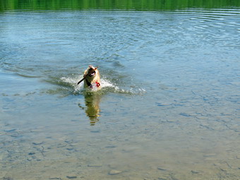 We continued along the Flynn Trail and I noticed that the trail needed some serious lopping. At the next trail junction, we stayed to the left to follow the Flynn Trail down to Hodge Pond. The grass on the trail had been mowed which was a big improvement from the tall grass on the first part of the Flynn Trail. As we walked out into the sun, I noticed the apparent increase in temperature. I also noticed there was a breeze which helped offset the sun. We walked out into the field by Hodge Pound and then over to the shore. Sheila immediately went for a swim while I took some pictures of the pond. The sky was blue but there were no nice white clouds to increase the contrast with the rest of the sky. After a drink and a bar, we walked back to the Flynn Trail and continued on the west side of Hodge Pond. The bars I am using now are Quest which have 20 grams of protein and only 4 grams of carbs. The flavors are good but the consistency is the same as most other high protein bars. The trail was mostly dry with a few damp spots. At the next trail junction we stayed to the left to take the Flynn Trail up the hill rather than the jeep road around the back of the pond. We passed through the gate and found the trail was a little damper with more muddy spots. The trees and bushes were beginning to close in on the trail and really needed several people with loppers to cut them back. Soon we came to the Quick Lake Trail at Junkyard Junction. It was 11:05 AM and we had hiked 3.3 miles which is almost exactly halfway through the hike. We turned left to start the loop back. The trail initially rolls some but eventually descends toward Iron Wheel Junction. The trail was damp and muddy in several places. There were also several new blowdowns and I tried to remove as many as I could.
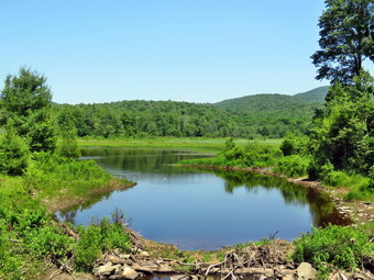 At 11:40 AM we turned right at Iron Wheel Junction after hiking 4.9 miles. The turn allowed us to stay on the Quick Lake Trail heading for Frick Pond. As we walked, I continued to pick up branches and noted some lopping would be a good idea. We came to and crossed the small stream through the woods. Sheila took a moment to swim in the water even though the volume was very low. There was a large hardwood tree down across the trail in the "spruce tunnel" but it was flat on the ground. There was another older tree a little farther along. We walked out of the spruce tunnel and found some more branches on the trail which I removed. This part of the trail was also dry compared to its usual status. We passed by the junction with the Big Rock Trail on the left and were soon at the bridge over the Frick Pond Outlet. I dropped my pack and got out the camera. I have taken hundreds of pictures form the bridge but can't resist stopping to take a few more. The beaver dam was still out but it looked like a few sticks had been replaced. I took some pictures of Sheila on the bridge and some ducks out on the pond. We walked up the hill from Frick Pond to Gravestone Junction and continued straight ahead on the Quick Lake Trail. The trail was a little damp but not really wet for almost the entire way back to the car. We passed by the register and continued straight ahead on the woods road back to the car. There was now one other car in the lot. We were back at the car at 12:20 PM having hiked 6.3 miles in 2 hours and 35 minutes with a vertical gain of 900 feet. This was an average of 2.4 mph overall with about 10 minutes of stopped time.
On Saturday, June 30th, I was set to participate in an introduction to trail maintenance session sponsored by the NYNJTC and Morgan Outdoors. Alex Bradley, the new Catskills Program Coordinator, was scheduled to be at the session so that people could meet him. The session was postponed from an earlier date due to cool weather and rain to the weekend before July 4th which was supposed to be the hottest of the summer! I arrived at Morgan Outdoors at about 10:00 AM and Alex got there shortly after. I enjoyed talking with him as we waited for the participants to arrive. Some would meet us at 10:30 AM in town an other would be at the Frick Pond trailhead at 11:30 AM. I would have preferred to get started at least an hour earlier since the temperature was expected to rise to near 90 degrees during the day. One woman arrived with four children from a program she helps supervise and we got acquainted. They were all students in the Liberty school system where I taught and still coach. They were upper elementary or middle school students with one going into the ninth grade. We waited around until 11:00 AM and headed toward Frick Pond. I had hoped that when I arrived there would be a group of people waiting as I had work I really wanted to get accomplished but no one was there. The rest of the group arrived and I started them on the paperwork which included a one-time volunteer application for the DEC and a list of participants. At 11:30 AM one more adult and child appeared but the adult decided to go for a walk and send her son with us! There was one more person that Lisa was waiting for but we finally got started at about 11:45 Am. We walked out the back of the big parking area on the Quick Lake Trail. I gave a shovel to one young man to clean out a couple of drainages. The other young people took turns using some loppers. I showed them my Silky Sugowaza and machete as example of other tools that can be sued to clear trails. We cut a few branches on the way to the register and I explained we had to cut as high as we could reach because the trails were popular for snowshoeing in the winter. Two or three feet of snow put people's heads that much higher! We turned left at the trail register and continued lopping branches developing a nice system of taking turns cutting. The young man with the shovel did a good job of cleaning out some blocked drainages. I like working with students and have done it for over 40 years. The young people seemed to be having fun. After cutting some briars and brush near Gravestone Junction we stopped at the memorial marker just off the trail. I told the group the story of the two children that were killed when their cabin caught fire in the 1930's. At the junction we stayed to the left on the Quick Lake Trail and continued to cut branches with the saw or loppers. The young people began to develop a system where one would cut and the others would remove the brush which is exactly the kind of cooperation we are trying to foster. We walked down to the bridge over the out let of Frick Pond and everyone commented on the view. A father and daughter who were late to the initial gathering joined us and we had another round of introductions. Just over the bridge one of the young people knew of a geocache and retrieved it from the base of a pine tree. The box was gone and someone had left the plastic bag open so the list inside was pretty wet. After a few minutes, we continued on the trail. The young man with the shovel stayed with Alex to open a channel to drain a spot that usually has a lot of water. We continued along the trail to lop some more branches. At this point several of the adults decided to go on ahead. This was unfortunate as the young people with the loppers followed and I was soon left alone. I continued to trim some branches that the others had ignored. I walked ahead to the next trail junction and did not see anybody ahead. I often clear trails by myself and can be alone anytime. I decided I would rather attend my granddaughter's birthday party than be alone on the trail. I walked back toward the bridge and made sure that Alex knew I was leaving. I walked back to the bridge and out the Quick Lake Trail toward my car. There were several groups walking in the opposite direction in the trail. At the register I met a group that was confused about how to get to Frick Pond. I gave them directions. They were also interested in my tools so I stopped and talked to them for a few minutes. They particularly liked the Silky saw. I walked back on the Quick Lake Trail and left to drive back to Livingston Manor.
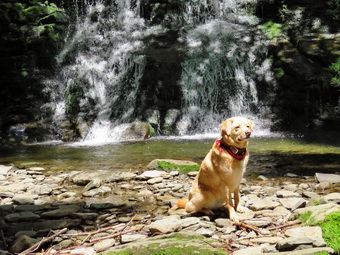
![]()
![]()
![]()
![]()
![]() On Friday, June 29th I had planned to hike the Quick Lake Trail to Quick Lake and then return on Ty snowmobile trails. The round trip hike is over 14 miles and I wanted to test myself for longer hikes on the Finger Lakes Trail. An ambulance call during the night made getting up early difficult! By the time I got up and was ready to go I knew I would not arrive at the trailhead until 11:00 AM. A 14 mile hike would take at least 7 hours and would take me through a very warm and humid afternoon. I decided I would go to Trout Pond as I had not been there in some time. I thought I would take along my Silky Sugowaza saw to cut small blowdowns and a machete to work on the Japanese knotweed near the beginning of the trail. As I was getting ready to leave in the mid morning the temperature was already in the 70's and the humidity was high making the air seem "heavy". I decided to get dressed and get my gear together. Sheila was ready to go and stayed close so that I would not forget her. I got dressed in a long-sleeved crew top with a short-sleeved baselayer. I put on a pair of RailRiders hiking pants which are expensive but last along time and have features like deep pockets and a generous cut which I really like. The pants have Velcro closures at the ankles which I hoped would mean I did not need gaiters. The ticks have been very numerous so far this season especially farther south. I decided to wear my Keen Glarus hiking boots which are my "go to" hiking boots. I got our gear together and put Sheila in the back seat as we headed for Roscoe on the Quickway a little around 10:30 AM. I drove out the Rockland Flats on Route 206. Just after the Roscoe Nursing Home I turned left on Morton Hill Road and followed it for 3 miles to the intersection with Russell Brook Road. I turned around and parked on the side of the road avoiding the private parking area. When I opened the car door, I was hit my a blast of hot and humid air. I checked the car thermometer and found that it was 74 degrees with only a slight breeze. I grabbed my poles, set the GPS and started down Russell Brook Road. As we walked down the road I thought the first camping site on the right might be occupied but it was empty. The forecast was plenty of sun with the temperature rising into the high 80's with accompanying high humidity. I listened for the sound of the water in the brook and was supplied that I did not hear much since there had been a thunderstorm with plenty of rain the previous evening. The large car camping spot on the left was occupied and I made sure to keep Sheila on her leash as we walked by. When we came to the viewpoint over the upper falls, I could see there was only a small volume of water going over the falls so I decided to leave the pictures for later if I even bothered to take any. There were three cars in the lower lot and I expected some to be camping and others to be hiking. We continued down the road and crossed the bridge over Russell Brook. I found that the Japanese knotweed had really come back strong after the winter and was beginning to encroach on the trail. I hoped I would have enough motivation after the hike to get some of it cleared! We continued on the road to the trail junction just after the register and stayed straight ahead to walk to Trout Pond first.
On Friday, June 29th I had planned to hike the Quick Lake Trail to Quick Lake and then return on Ty snowmobile trails. The round trip hike is over 14 miles and I wanted to test myself for longer hikes on the Finger Lakes Trail. An ambulance call during the night made getting up early difficult! By the time I got up and was ready to go I knew I would not arrive at the trailhead until 11:00 AM. A 14 mile hike would take at least 7 hours and would take me through a very warm and humid afternoon. I decided I would go to Trout Pond as I had not been there in some time. I thought I would take along my Silky Sugowaza saw to cut small blowdowns and a machete to work on the Japanese knotweed near the beginning of the trail. As I was getting ready to leave in the mid morning the temperature was already in the 70's and the humidity was high making the air seem "heavy". I decided to get dressed and get my gear together. Sheila was ready to go and stayed close so that I would not forget her. I got dressed in a long-sleeved crew top with a short-sleeved baselayer. I put on a pair of RailRiders hiking pants which are expensive but last along time and have features like deep pockets and a generous cut which I really like. The pants have Velcro closures at the ankles which I hoped would mean I did not need gaiters. The ticks have been very numerous so far this season especially farther south. I decided to wear my Keen Glarus hiking boots which are my "go to" hiking boots. I got our gear together and put Sheila in the back seat as we headed for Roscoe on the Quickway a little around 10:30 AM. I drove out the Rockland Flats on Route 206. Just after the Roscoe Nursing Home I turned left on Morton Hill Road and followed it for 3 miles to the intersection with Russell Brook Road. I turned around and parked on the side of the road avoiding the private parking area. When I opened the car door, I was hit my a blast of hot and humid air. I checked the car thermometer and found that it was 74 degrees with only a slight breeze. I grabbed my poles, set the GPS and started down Russell Brook Road. As we walked down the road I thought the first camping site on the right might be occupied but it was empty. The forecast was plenty of sun with the temperature rising into the high 80's with accompanying high humidity. I listened for the sound of the water in the brook and was supplied that I did not hear much since there had been a thunderstorm with plenty of rain the previous evening. The large car camping spot on the left was occupied and I made sure to keep Sheila on her leash as we walked by. When we came to the viewpoint over the upper falls, I could see there was only a small volume of water going over the falls so I decided to leave the pictures for later if I even bothered to take any. There were three cars in the lower lot and I expected some to be camping and others to be hiking. We continued down the road and crossed the bridge over Russell Brook. I found that the Japanese knotweed had really come back strong after the winter and was beginning to encroach on the trail. I hoped I would have enough motivation after the hike to get some of it cleared! We continued on the road to the trail junction just after the register and stayed straight ahead to walk to Trout Pond first.
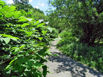 The woods road was damp in spot but not really very wet. I picked up some branches and pieces of tree trunk along the way and moved them off the trail. In several spots I had to put down my pack and get out the saw to removed some small blowdowns. When we arrived at the pond, there were on other hikers present and Sheila made a dash for the lake. She jumped in and started to swim around while I dropped my pack and got out the camera. I took some shots of the pond with blue skies and a few puffy white clouds. I also too a couple of pictures of the outlet showing the water several feet from going over the spillway. I turned my attentions to Sheila and threw a stick several times into the pond so she could retrieve it. Each time I threw it a little farther and took pictures of her swimming. Eventually we both grew tired and I packed up and headed out. We continued on the main trail on the east side of Trout Pond walking toward the inlet end and the lean-tos. The trail continued to be damp in places but was much drier than I had seen it in some time. As we approached the first the first lean-to, I could see it was occupied. I really didn't determine how many people were present as I had my eye on a large dog! The dog was making a lot of noise but was on a leash proving there are some other responsible dog owners. We crossed the bridge over the inlet stream and I looked out at the pond to see a blue sky with white clouds. We walked a little on the trail to the upper lean-to and I took a few shots of the pond. We turned right to follow the trail up Cherry Ridge. As we hiked I found it satisfying to look at the many places where I had cleared branches and blowdowns from the trail. There were some new branches on the trail and several small blowdowns I was able to clear by moving them to the side of the trail. Many of the rocks were damp and slippery and I paid careful attention to where I put my feet. Soon we were at the highest point on Cherry Ridge and starting down the other side. This part of the trail can be a stream much of the time but on this day it was almost completely dry. It was obvious that there had been water on the trail from the green moss that was growing on all the rocks and roots. Sheila was having a great time following some animal trails and pouncing after chipmunks. Soon we were at the woods road and snowmobile trail that runs by Mud Pond. We turned left and started the short walk uphill on a trail that was barely damp. At the top of the hill we began the long descent back to the trail junction where we had started. The descent lasts for .7 miles and drops 385 feet to a bridge that crosses the outlet stream from Trout Pond. This part of the trail had a little more water but was not as wet as I have seen it before. The streambed next to the trail was completely dry. I continued to cut a few branches that were in the trail. When we came to the bridge over the outlet stream from the pond I was surprised that no one had occupied the large campsite there.
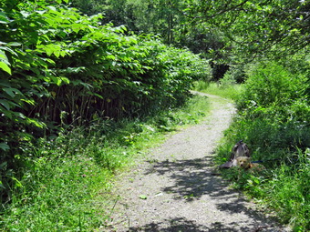 At the junction we turned right and headed back out toward the lower parking area. We turned left on the path that leads over to the base of the falls and fought through the tall grass on the left and the knotweed on the right. We walked over to the path down to the streambed and descended to the stream. There wasn't much water going over the falls and the stream had a greatly reduced volume. I got out the camera and took some pictures as I though the light was right. I posed Sheila in front of the waterfall and took a few more shots. I packed up and we headed back out to the main trail. It was about 1:35 PM and the temperature seemed to be in the low 80's. I still felt I had some energy left so I leashed Sheila to a tree and took some pictures of the knotweed on the trail. I put the camera away and took out my machete and started in on the knotweed. The machete is the perfect tool for this job and I quickly cut the hollow stalks. The problem was that I had to cut them and throw them on the other side of the trail. There was a LOT of knotweed to cut and each time I cut some stalks other would lean into the trail. I kept cutting and disposing of the weeds until I looked up and saw a dog coming toward me. One dog was followed by two more with the owner behind them. This owner obviously had no regard for the rules and no common courtesy. I informed her my dog was leashed to a tree and might no appreciate other dogs. This didn't stop her dogs from trying to say "hello" to Sheila who did not appreciate it. So many of these incidents could be avoided if dog owners would act responsibly! After the dogs and owners left, I continued to cut the knotweed including some near the bridge. After almost an hour of cutting, Sheila and I walked back up to the lower parking area and then up the road to the car. Sometimes the walk back up Russell Brook Road seems long and tedious but I was still feeling fresh Although a little tired. It was 2:45 PM when we arrived back at the car after hiking 5.7 miles in 3 hours and 45 minutes with a total of 1 hour and 15 minutes stopped. We had a 1118 foot total ascent. The temperature on the car thermometer was 90 degrees!
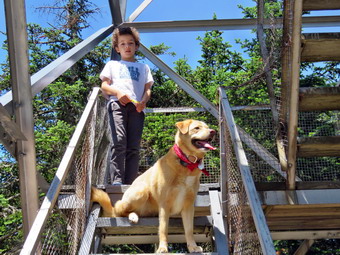
![]()
![]()
![]()
![]()
![]() On Tuesday, June 26th, my grandson Bryce was coming to our house and wanted to hike. He arrived at about 9:30 AM and we got ready to hike. I suggested we hike to the Balsam Lake Mountain since it is a 3500 foot peak and has a fire tower for a good view. The temperature was in the high 60's as we were getting ready to leave. The temperature was supposed to rise into the mid to high 70's. While we were getting ready, Sheila was always nearby making it very clear that she wanted to go. I got dressed in a long-sleeved crew top with a short-sleeved baselayer. I put on a pair of RailRiders hiking pants which are expensive but last along time and have features like deep pockets and a generous cut which I really like. The pants have Velcro closures at the ankles which I hoped would mean I did not need gaiters. The ticks have been very numerous so far this season especially farther south. I decided to wear my Keen Glarus hiking boots which are a good choice for a rocky trail like the one to Balsam Lake Mountain. We got our gear together and put Sheila in the back seat as we headed toward Roscoe on Old Rt 17 at 9:45 AM. I turned right on the Beaverkill Road and headed north toward Lew Beach and Turnwood. The sky was almost cloudless as we drove through Lew Beach and the temperature was reading in the high 60's! Just passed Lew Beach at the Ulster County line the road was complete torn up and road crews were working to repave a section of road stretching almost to Turnwood. We waited until we were allowed to pass and I drove slowly on the unpaved road surface. Eventually we reached Barkaboom Road where I followed the Beaverkill Road to the right. I pointed out the Beaverkill Falls to Bryce although there wasn't much water in the stream. We hit the point where the road turns to gravel and passed the Buddhist monastery to continue toward the trailhead. There were a few places where the road which had narrowed was now a little wider than the last time I had been to Balsam Lake Mountain. As we neared the final section of road, there was a front-end loader from one of the road crews on the road. The operator politely pulled over so that we could pass and I assumed that the crew would be working to clear the ditches on the last section of road. We arrived at the parking area and found only one other car in the lot. The car had several stickers related to hiking and I told Bryce I probably knew the owner. The temperature was 70 degrees and the sun was shining with a slight breeze. We were on the trail at 10:50 AM heading toward the first trail junction where I intended to turn left and hike up the steep side of the mountain. As we walked up the trail I noticed several trees hanging over the trail and although they seemed safe I would prefer that they were gone. The trail had only a few muddy places and was mostly dry. There were also a few blowdowns across the trail that had been partially cleared but some more work needs to be done. A short distance up the trail, near the trail register, Sheila alerted and I saw a woman walking toward us. I put Sheila on her leash as the woman recognized me and said "Hello". It was Laurie Rankin who had been working on the trail. We stopped and talked for a few minutes about several hiking topics. Laurie and her husband Tom are volunteers who keep the fire tower open on weekends during the summer. We eventually parted and Bryce and I made the trail junction at .9 miles by 11:20 AM. We turned left up the mountain without stopping. I had decided to take my time since I had not hiked a trail this steep in some time but Bryce seemed to be undeterred. This first part of the trail is a gentle climb and I was feeling pretty good without stopping to rest. Over the next half mile the trail gains about 750 feet before leveling off which means an average of around a 28% grade! I had to keep calling ahead to Bryce wait for me and he would sit on a rock until I caught up and then immediately begin hiking again without allowing me to rest! I decided to stop a few times so that I could catch my breath but the pace was pretty fast and the stops were short. Despite the grade, the hike seemed to go pretty quickly and we were soon passing the spur trail to the lean-to. We passed the 3500 foot sign and were soon at the spring. I encouraged Sheila to take a drink but she seemed uninterested. We walked up the stone steps to the summit plateau and continued on toward the fire tower.
On Tuesday, June 26th, my grandson Bryce was coming to our house and wanted to hike. He arrived at about 9:30 AM and we got ready to hike. I suggested we hike to the Balsam Lake Mountain since it is a 3500 foot peak and has a fire tower for a good view. The temperature was in the high 60's as we were getting ready to leave. The temperature was supposed to rise into the mid to high 70's. While we were getting ready, Sheila was always nearby making it very clear that she wanted to go. I got dressed in a long-sleeved crew top with a short-sleeved baselayer. I put on a pair of RailRiders hiking pants which are expensive but last along time and have features like deep pockets and a generous cut which I really like. The pants have Velcro closures at the ankles which I hoped would mean I did not need gaiters. The ticks have been very numerous so far this season especially farther south. I decided to wear my Keen Glarus hiking boots which are a good choice for a rocky trail like the one to Balsam Lake Mountain. We got our gear together and put Sheila in the back seat as we headed toward Roscoe on Old Rt 17 at 9:45 AM. I turned right on the Beaverkill Road and headed north toward Lew Beach and Turnwood. The sky was almost cloudless as we drove through Lew Beach and the temperature was reading in the high 60's! Just passed Lew Beach at the Ulster County line the road was complete torn up and road crews were working to repave a section of road stretching almost to Turnwood. We waited until we were allowed to pass and I drove slowly on the unpaved road surface. Eventually we reached Barkaboom Road where I followed the Beaverkill Road to the right. I pointed out the Beaverkill Falls to Bryce although there wasn't much water in the stream. We hit the point where the road turns to gravel and passed the Buddhist monastery to continue toward the trailhead. There were a few places where the road which had narrowed was now a little wider than the last time I had been to Balsam Lake Mountain. As we neared the final section of road, there was a front-end loader from one of the road crews on the road. The operator politely pulled over so that we could pass and I assumed that the crew would be working to clear the ditches on the last section of road. We arrived at the parking area and found only one other car in the lot. The car had several stickers related to hiking and I told Bryce I probably knew the owner. The temperature was 70 degrees and the sun was shining with a slight breeze. We were on the trail at 10:50 AM heading toward the first trail junction where I intended to turn left and hike up the steep side of the mountain. As we walked up the trail I noticed several trees hanging over the trail and although they seemed safe I would prefer that they were gone. The trail had only a few muddy places and was mostly dry. There were also a few blowdowns across the trail that had been partially cleared but some more work needs to be done. A short distance up the trail, near the trail register, Sheila alerted and I saw a woman walking toward us. I put Sheila on her leash as the woman recognized me and said "Hello". It was Laurie Rankin who had been working on the trail. We stopped and talked for a few minutes about several hiking topics. Laurie and her husband Tom are volunteers who keep the fire tower open on weekends during the summer. We eventually parted and Bryce and I made the trail junction at .9 miles by 11:20 AM. We turned left up the mountain without stopping. I had decided to take my time since I had not hiked a trail this steep in some time but Bryce seemed to be undeterred. This first part of the trail is a gentle climb and I was feeling pretty good without stopping to rest. Over the next half mile the trail gains about 750 feet before leveling off which means an average of around a 28% grade! I had to keep calling ahead to Bryce wait for me and he would sit on a rock until I caught up and then immediately begin hiking again without allowing me to rest! I decided to stop a few times so that I could catch my breath but the pace was pretty fast and the stops were short. Despite the grade, the hike seemed to go pretty quickly and we were soon passing the spur trail to the lean-to. We passed the 3500 foot sign and were soon at the spring. I encouraged Sheila to take a drink but she seemed uninterested. We walked up the stone steps to the summit plateau and continued on toward the fire tower.
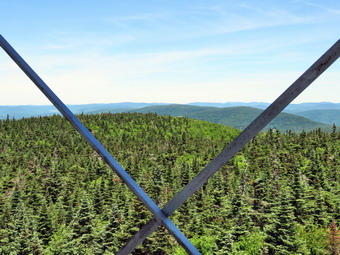 Bryce knew we were going to a fire tower but apparently Bryce thought it would be right at the top of the climb. As we hiked across the summit plateau, Bryce kept worrying that we had missed the tower. He was very relieved when we looked ahead and saw the clearing with the tower. We arrived at the tower clearing at 12:10 PM after hiking 1.7 miles and walked over to the picnic table. I got out my camera a took a few pictures of the tower and then posed Bryce and Sheila at the table and on the lower landing of the tower. After that I leashed Sheila to the table and we walked over to the fire tower. Bryce seemed to have no problem climbing the tower and we were soon at the landing just below the cab. There was one step with a red X which indicated it was suspected and needed to be replaced. I could tell as soon as we were above the tree line as the breeze picked up considerably. I took pictures in all direction but the landscape was mostly green without much of a break. The mountains in the distance were hazy but there were a few clouds to break up the sky. After taking a few pictures, we descended the tower. I told Bryce to hold onto the rail and I did also. Somehow I caught my thumb on a sharp edge and removed a chunk. My thumb started bleeding which did not please me! We continued to the bottom of the tower and walked back to the picnic table. I searched my pack for some first ad supplies and, with Bryce's help, I bandaged my thumb putting some pressure on it. We got a drink and gave Sheila one. Bryce and I split a bar for a snack and then I packed up my camera to continue our hike. We walked down the trail on the other side of the mountain passing the cabin. Walking down the mountain seemed MUCH easier than the climb up the other side. The trail was dry and we had to be careful about slipping on the loose gravel. Soon we were approaching the junction with the trail that connects Millbrook Road to the Beaverkill Road. There is a gate at the bottom of the trail and just after this gate is the trail junction. We turned right at the trail junction to start back toward the car. The trail is a little rough to begin with but it is a descent. There were quite a few branches hanging into the trail and a few blowdowns. When We arrived at the first trail junction Bryce took a quick look around and knew exactly where we were. We continued on toward the car by retracing our steps. We were back in the parking area at 1:45 PM after hiking 4.3 miles and climbing 1200 feet in elevation. I was happy to have hiked a 3500 foot peak but it made me realize I need to hike a few more! Bryce, on the other hand, did not seem to have any trouble with the climb. Laurie's car was gone but another car was in the parking lot. On the way home we again had to wait for the road work but the crews seemed to be making progress very quickly.
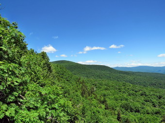
![]()
![]()
![]()
![]()
![]() On Monday, June 25th I had decided to get in hike after an early morning doctor's appointment. I was home a little after 10:00 AM and asked Cindy if she wanted to hike to Giant Ledge and she agreed. The temperature was in the low 50's early in the morning but started to rise to the low 60's by the time we were getting ready to go. I hoped there would not be too many people at Giant Ledge since even though it is a very popular destination it was a Monday. While we were getting ready, Sheila was always nearby making it very clear that she wanted to go. I got dressed in a long-sleeved crew top with a short-sleeved baselayer. I put on a pair of RailRiders hiking pants which are expensive but last along time and have features like deep pockets and a generous cut which I really like. The pants have Velcro closures at the ankles which I hoped would mean I did not need gaiters. The ticks have been very numerous so far this season especially farther south. I decided to wear my Keen Glarus hiking boots which are a good choice for a rocky trail like the one to Giant Ledge. We got our gear together and put Sheila in the back seat as we headed out the DebRuce Road around just before 11:00 AM. The temperature was in the low 60's as I drove along DeBruce Road. I turned left onto the Frost Valley Road and almost immediately ran into road construction. We were stopped for at least 15 minutes before we could pass through. Ulster County had a long section of road completely torn up so that I had to drive over piles of gravel and hope that nothing bounced up to damaged the car. Eventually we made it back to paved road but we both had decided we would take another way home! There were no cars parked at Biscuit Brook but quite a few in the Slide Mountain parking area. When we arrived at the big bend in Route 47, the lot was almost full which I found incredible for a Monday morning. I was able to find a parking spot at the end of the area near the portable bathroom. There were a few people getting ready to start out and I wanted to get ahead of them so that I did not have to keep Sheila on her leash for the whole hike. We crossed the road to start the hike at 11:35 AM. The trail was wet in spots with some mud but seemed to be drying out. The stream under the bridge was almost nonexistent. As I climbed over the normally rocky areas, I was reminded of how many small but very rocky climbs are on this trail! As we climbed one of the first we passed a woman sitting on a rock and another family group taking a rest. We could hear a group behind us and Cindy and I set a quick pace to avoid them. I let Sheila off her leash and she stayed very close. We caught up to and passed another group. Each time we met people, I put Sheila on her leash. Within about 30 minutes we had hiked the .75 miles to the trail junction meeting a few people coming down the trail and passing a few more going up. I have made this in 15 minutes under ideal conditions but I wasn't in any real hurry on this day. The trail straight ahead would take us to Woodland Valley but we made a left turn to go to Giant Ledge.
On Monday, June 25th I had decided to get in hike after an early morning doctor's appointment. I was home a little after 10:00 AM and asked Cindy if she wanted to hike to Giant Ledge and she agreed. The temperature was in the low 50's early in the morning but started to rise to the low 60's by the time we were getting ready to go. I hoped there would not be too many people at Giant Ledge since even though it is a very popular destination it was a Monday. While we were getting ready, Sheila was always nearby making it very clear that she wanted to go. I got dressed in a long-sleeved crew top with a short-sleeved baselayer. I put on a pair of RailRiders hiking pants which are expensive but last along time and have features like deep pockets and a generous cut which I really like. The pants have Velcro closures at the ankles which I hoped would mean I did not need gaiters. The ticks have been very numerous so far this season especially farther south. I decided to wear my Keen Glarus hiking boots which are a good choice for a rocky trail like the one to Giant Ledge. We got our gear together and put Sheila in the back seat as we headed out the DebRuce Road around just before 11:00 AM. The temperature was in the low 60's as I drove along DeBruce Road. I turned left onto the Frost Valley Road and almost immediately ran into road construction. We were stopped for at least 15 minutes before we could pass through. Ulster County had a long section of road completely torn up so that I had to drive over piles of gravel and hope that nothing bounced up to damaged the car. Eventually we made it back to paved road but we both had decided we would take another way home! There were no cars parked at Biscuit Brook but quite a few in the Slide Mountain parking area. When we arrived at the big bend in Route 47, the lot was almost full which I found incredible for a Monday morning. I was able to find a parking spot at the end of the area near the portable bathroom. There were a few people getting ready to start out and I wanted to get ahead of them so that I did not have to keep Sheila on her leash for the whole hike. We crossed the road to start the hike at 11:35 AM. The trail was wet in spots with some mud but seemed to be drying out. The stream under the bridge was almost nonexistent. As I climbed over the normally rocky areas, I was reminded of how many small but very rocky climbs are on this trail! As we climbed one of the first we passed a woman sitting on a rock and another family group taking a rest. We could hear a group behind us and Cindy and I set a quick pace to avoid them. I let Sheila off her leash and she stayed very close. We caught up to and passed another group. Each time we met people, I put Sheila on her leash. Within about 30 minutes we had hiked the .75 miles to the trail junction meeting a few people coming down the trail and passing a few more going up. I have made this in 15 minutes under ideal conditions but I wasn't in any real hurry on this day. The trail straight ahead would take us to Woodland Valley but we made a left turn to go to Giant Ledge.
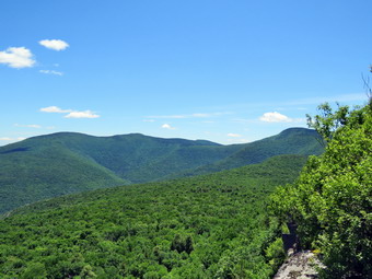 The next .3 miles or so was almost flat and the trail was still dry. We ascended through a few small climbs. We passed a couple of hikers and again met a few coming down from the ledges. The trail is incredibly rocky and I took every chance to let Sheila off her leash and use my poles. Soon we began the climb up to Giant Ledge passing the sign for the spring on the way. We started the final climb up to the Giant Ledge plateau by passing a few more people. I was surprised at how quickly this last part went and before I knew it we were at the top. I had Sheila on her leash and was carrying my poles. Sheila does a good job of pulling on uphill sections which really helps. It often seems to me that up, down and flat are all the same to her. We walked across the trail and down to the first lookout where there were a couple of young people from Long Island. I tied Sheila to a tree and got out my camera to take some pictures of the wonderful view from the first lookout. I took a lot of shots before getting my cell phone to use my Peak Advisor and Peak Finder apps to see if they could identify the mountains. They both did a good job and I showed them to the young hikers and answered some questions for them. We could see Slide, Cornell and Wittenberg to the right. After that was Friday and in the distance the mountains of the Devil's Path. On the far left was Panther Mountain. At this point father and his two sons arrived at the viewpoint. They are from Maryland and had been hiking in New Hampshire. On the way back they decided to stop in the Catskills for a few days. They had a lot of questions about places to visit and I gave them a lot of information. We decided to move on and visit some other unoccupied viewpoints so that I could take some more pictures. I knew the hike wasn't very long and wanted to walk the entire ledge plateau until it began to descend to the col with Panther. We continued to the next lookout which was empty. I took some pictures of Sheila and Cindy on the ledge and then took more pictures of the valley below and the surrounding mountains. We visited three more viewpoints and stopped where the trail began to descend. I was ready to hike to Panther and asked Cindy who politely declined the offer. It was 1:10 PM when we turned around after hiking about 1.8 miles. We started back down from the ledges with Sheila on her leash and without the use of my poles. There were several groups heading back at the same time and we tried to pass several of these that were moving slowly. I soon decided that my knees would do better with my poles and I let Sheila off her leash as often as I could. We continued to meet hikers and groups still coming up the trail. We passed people descending ahead of us and were passed only the father and his two sons. Each time we met a group I out Sheila on her leash. We did meet one or two more dogs which their owners had under control. I was moving very quickly but Cindy was having some trouble on the descent which is usually the case. Sheila and I waited a few times. Eventually we were at the trail junction where we turned right to start down the final .75 miles of trail. The descent is where the rockiness of the trail becomes even more evident than on the climb! We finally arrived at the fridge over the stream where Sheila got a drink and took a cooling dip before we continued out to the parking area. The lot was still full and cars were parked on the side of the road below the parking area. We were back at the car at 2:20 PM after covering 3.6 miles in 2 hours and 45 minutes with an ascent of about 1195 feet. We decided to drive out to Route 28, turn left and drive to Margaretville. We stopped a t5he gas station there and bough a few snacks before continuing on to take the BWS roads back toward Livingston Manor. After a few miles I could see an accident ahead. The driver of a low boy with a large piece of machinery had driven off the road. The recovery would take at least and hour. I tuned around and drove back to Route 30 where I turned left following Route 30 all the way to Route 206. It was a beautiful day for hiking and driving!
![]()
![]()
![]()
![]() On Friday, June 22nd, my grandson, Bryce, only had an hour of school because it was the last day of school before summer vacation. I volunteered to pick him up and take him on a hike. I though this would be perfect for the first hike of summer after a long week of being away from the forests. Bryce agreed and I picked him up at 9:00 AM at his school. We had a few errands to do and we had to stop by his house to pick up a pair of long pants for hiking. By the time we got to Livingston Manor, Bryce needed something to eat so we weren't ready to leave the house until 11:40 AM. I decided we would return to Frick Pond and hike a loop up the Flynn Trail, down the Big Rock Trail to Times Square and then around the loggers Loop to Iron Wheel Junction. From here we would turn left and follow the Quick Lake Trail back to the car. This would be a slightly longer loop than we had done the previous Friday adding about 1.5 miles. I also decided to carry along my Silky Sugowaza saw to clear some of the small blowdowns I knew were on the trail. The temperature was in the mid 70's which felt comfortable. While we were getting ready, Sheila was always nearby making it very clear that she wanted to go. I got dressed in a long-sleeved crew top with a short-sleeved baselayer. I put on a pair of RailRiders hiking pants which are expensive but last along time and have features like deep pockets and a generous cut which I really like. The pants have Velcro closures at the ankles which I hoped would mean I did not need gaiters. The ticks have been very numerous so far this season especially farther south. I decided to wear my Keen Glarus hiking boots which I had recently waterproofed as I knew the trails might be damp. We left Livingston Manor and I drove out the DeBruce Road about 6 miles to Mongaup Road. I turned left and continued up the road to the point where it splits. I stayed left on Beech Mountain Road and drove to the parking areas on the left. The road was smooth and hard packed after the Town of Rockland had worked on it. I pulled into the larger parking area as the smaller one had a horse trailer parked in it! This was the second time in a week that the same horse trailer had been at the trailhead. Horses are allowed in the Willowemoc Wild Forest but NOT on marked hiking trails. This means there are very few places that horses can legally be ridden. I like horses but they can be a problem on hiking trails. Heavy usage can increase trail erosion and riders never clean up what their mounts leave behind. I had explained the regulations to the riders the last time we met but they apparently did not believe me! We got ready to head out on the Flynn Trail with insects circling our heads. I set my GPS and we walked across the road to get on the Flynn Trail. This trail is sited along what used to be Beech Mountain Road which was the access for the Beech Mountain Boy Scout Camp. We walked the trail through the woods and just before the right turn onto the woods road we came to a locust tree overhanging the trail. The tree had long, sharp thorns so I approached it very carefully. I cut it down and then decided to cut it into a few pieces to make it easier to drag off the trail. It didn't take long and the job was done. We continued on the trail made the right turn onto the woods road. The trail gains a little over 600 feet in 1.75 miles to the highest point at the junction with the Big Rock Trail. The day was warm and humid but we had a good time as we hiked up the trail. We passed through the arch Cindy and I had cut through an enormous hemlock that had fallen across the trail. We stopped here to cut a few low branches and then continued. Along the way Sheila alerted and I looked ahead to see two horses coming toward us. I put Sheila on her leash and as we passed I simply said "Hello" as I knew my explanation of the rules would fall on deaf ears. A little farther up the trail Sheila lunged into the ferns to pounce on a baby bird. It took some very stern talk from me to get her to leave the birds alone as her instincts are very strong.
On Friday, June 22nd, my grandson, Bryce, only had an hour of school because it was the last day of school before summer vacation. I volunteered to pick him up and take him on a hike. I though this would be perfect for the first hike of summer after a long week of being away from the forests. Bryce agreed and I picked him up at 9:00 AM at his school. We had a few errands to do and we had to stop by his house to pick up a pair of long pants for hiking. By the time we got to Livingston Manor, Bryce needed something to eat so we weren't ready to leave the house until 11:40 AM. I decided we would return to Frick Pond and hike a loop up the Flynn Trail, down the Big Rock Trail to Times Square and then around the loggers Loop to Iron Wheel Junction. From here we would turn left and follow the Quick Lake Trail back to the car. This would be a slightly longer loop than we had done the previous Friday adding about 1.5 miles. I also decided to carry along my Silky Sugowaza saw to clear some of the small blowdowns I knew were on the trail. The temperature was in the mid 70's which felt comfortable. While we were getting ready, Sheila was always nearby making it very clear that she wanted to go. I got dressed in a long-sleeved crew top with a short-sleeved baselayer. I put on a pair of RailRiders hiking pants which are expensive but last along time and have features like deep pockets and a generous cut which I really like. The pants have Velcro closures at the ankles which I hoped would mean I did not need gaiters. The ticks have been very numerous so far this season especially farther south. I decided to wear my Keen Glarus hiking boots which I had recently waterproofed as I knew the trails might be damp. We left Livingston Manor and I drove out the DeBruce Road about 6 miles to Mongaup Road. I turned left and continued up the road to the point where it splits. I stayed left on Beech Mountain Road and drove to the parking areas on the left. The road was smooth and hard packed after the Town of Rockland had worked on it. I pulled into the larger parking area as the smaller one had a horse trailer parked in it! This was the second time in a week that the same horse trailer had been at the trailhead. Horses are allowed in the Willowemoc Wild Forest but NOT on marked hiking trails. This means there are very few places that horses can legally be ridden. I like horses but they can be a problem on hiking trails. Heavy usage can increase trail erosion and riders never clean up what their mounts leave behind. I had explained the regulations to the riders the last time we met but they apparently did not believe me! We got ready to head out on the Flynn Trail with insects circling our heads. I set my GPS and we walked across the road to get on the Flynn Trail. This trail is sited along what used to be Beech Mountain Road which was the access for the Beech Mountain Boy Scout Camp. We walked the trail through the woods and just before the right turn onto the woods road we came to a locust tree overhanging the trail. The tree had long, sharp thorns so I approached it very carefully. I cut it down and then decided to cut it into a few pieces to make it easier to drag off the trail. It didn't take long and the job was done. We continued on the trail made the right turn onto the woods road. The trail gains a little over 600 feet in 1.75 miles to the highest point at the junction with the Big Rock Trail. The day was warm and humid but we had a good time as we hiked up the trail. We passed through the arch Cindy and I had cut through an enormous hemlock that had fallen across the trail. We stopped here to cut a few low branches and then continued. Along the way Sheila alerted and I looked ahead to see two horses coming toward us. I put Sheila on her leash and as we passed I simply said "Hello" as I knew my explanation of the rules would fall on deaf ears. A little farther up the trail Sheila lunged into the ferns to pounce on a baby bird. It took some very stern talk from me to get her to leave the birds alone as her instincts are very strong.
Along the way we had been picking up branches and throwing them off the trail. We had also been pulling down low branches and trimming them. Bryce helped by holding them down while I cut them with the saw. At 1.15 miles we stopped for a few minutes to cut a low branch. Just before cutting it, I realized that there was another, larger tree caught in the branch and ready to fall on my head. I borough down the dead tree and cut it into several pieces and threw them off the trail. After dispatching the low branch we continued our hike. We stopped again at 1.5 miles to remove another shall blowdown in the trail. At 1.7 mile we hit the junction with the Big Rock Trail where we stopped for a drink. We turned left and made a rather rapid descent of the trail. As we walked I quizzed Bruce on science and math and the Bible. I found his knowledge to be remarkable! We made a few brief stops to cut branches and a longer one at 2.7 miles to remove a blowdown. At 3 miles we were at Times Square where we turned right on the Logger's Loop. Times Square was damp but I have seen it much wetter. We walked up the hill and soon came to a large tree trunk that had broken off and lodged vertically at the side of the trail. I knew this one was here but it was a little larger than I remembered. I reluctantly left the trunk where it was and we continued to walk uphill. When the trail leveled some near the seasonal pond on the right, we stopped for another drink before continuing. We cut a few more branches on the way to Iron Wheel Junction where we arrived at 2:25 PM after 4.2 miles of hiking. We turned left and started down the Quick Lake Trail toward Frick Pond. We continued to make good time stopping only a few times to cut branches. The small stream before the "spruce tunnel" didn't have much water and was easy to cross. I pointed out to Bryce a few of the larger trees I had cut on my last trip through. The trail was relatively dry and we were soon at the junction with the Big Rock Trail. We continued straight ahead on the Quick Lake Trail and came to the bridge over the outlet. The sky was overcast and I decided not to take any pictures and just get back to the car. We headed up the hill form the bridge and passed through Gravestone Junction. I could hear voices so I put Sheila on her leash as a coup0le of hikers approached us. We said "Hello" as we passed and I left Sheila on her leash. At the trail reviser we turned right to stay on the Quick Lake Trail and walked out to the larger parking area and the car. It was 3:05 PM and we had spent 3 hours and 5 minutes hiking 5.7 miles. We had stopped for 35 minutes to do trail work so our moving speed was 2.3 mph. The elevation gain was 890 feet. I think Bryce and I were both a little tired.