
Finger Lakes Trail
Besides the thirty-five 3500 foot peaks in the Catskills, there are many other smaller mountains to climb. In addition, there are hundreds of miles of trails to hike. There are also MANY other places to hike also. I have divided the Trails section into list of All Trail, the Catskills, the Shawangunks, Bear Mt/Harriman, East Hudson, West Hudson, New Jersey and Other Trails. The All Trails list includes over 400 different trails and may load slowly on your computer. The "divided" list should load more quickly.
You can view all the sections of the Finger Lakes Trail I have hiked here from East to West. Clicking on ![]() will bring up an index of trails. Clicking on
will bring up an index of trails. Clicking on ![]() will return you to the top of the page. Click HERE for a map of these sections.
will return you to the top of the page. Click HERE for a map of these sections.
Finger Lakes Trail: Bully Hill Rd to Slader Creek Rd
| Quick Look | ||||
|---|---|---|---|---|
| Difficulty | Round trip | Total climb | Internet Maps | |
| 10.2 mi. | 1562 ft. | AllTrails | ||
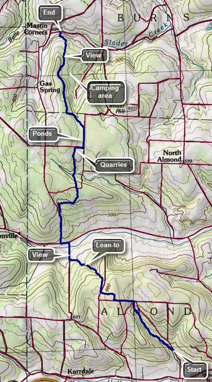
This hike starts where the trail crosses Bully Hill Rd and continues to the beginning of Map 9 on Slader Creek Road. It covers the first 10.2 miles of FLT Map 9. The hike is from south to north as is there is no parking available on Bully Hill Road. The parking on Slader Creek Road is also very limited. This requires a car spot or shuttle or a taxi. You may be able to get a ride from a "trail angel" through the Finger Lakes Trail Conference but many are only available on weekends. Village Taxi in Bath charges what I consider reasonable fees so that you can park your car on Slader Creek Road and have them take you to Bully Hill Road for the beginning of the hike. Take exit 34B off I86 west (State Route 17) to Arkport on Route 36. In Arkport watch for West Avenue just before you pass through the northern boundary of the village. Turn left on West Avenue which eventually becomes Route 961F or Route 70. I took exit 34B toward Arkport on Route 36 north. In Arkport I turned left or west on West Avenue which is Route 961F on some maps and Route 70 on others. Head north toward the village of Canaseraga looking for Tildon Hill Road on the left. After 3.8 miles turn left on Tildon Hill Road and drive west to County Route 13. Turn right or north and drive north only .7 miles to Slader Creek Road (Route 13C) on the left. Turn left and follow this road until you come to the Finger Lakes Trail trailhead just before the road meets Gas Springs Road. Park on the right shoulder just passed a driveway. You may want to check out Slader Creek as there are some reports it can be high at times. Leave one car here. Turn around and drive back out to Route 13 and head south until you come to a T. Turn left and then right on Bailey Hill Road. Turn left on Route 32 and travel a short distance to Bishopville Road. Turn right and continue on this road Until you get to Karr Valley Road (Route 2). Turn right and drive west to Bully Hill Road. Drive north .7 miles to the drop off point. Begin your hike by walking a short distance north on Bully Hill Road and then turning left into the woods. The first 1.5 miles of the trail parallels Bully Hill Road heading northwest and uphill. The trail can be muddy in spots but is very well marked and the track is very obvious. The trail also parallels a deeply cut stream bed which shows a lot of erosion but is often absolutely dry. Cross over the stream bed and then began to walk parallel to another deeply cut gorge. A little farther on walk through one of the many red pine plantations found along the Finger Lakes Trail. At Karr Road which is a dirt road turn left and walk a few hundred feet on the dirt road before walking straight into the woods on a woods road that begins a steep climb. The trail is easily visible and well marked but is often littered with sticks and branches. At the top of the hill continue almost straight ahead on another dirt road following the white blazes. Walk along the almost flat road until the trail turns right into the forest at about 2.0 miles. Walked along another woods road which eventually turns left to head toward Mike Dixon Road. Walk over some small bridges over a wet area and cross the road at 2.4 miles. The trail is directly across from the exit and parallels the road before turning and heading northwest. The walk is now through hardwood forests and begins a rather long descent. The trail is very rocky and continues to follow some impressive streambeds. At 3.2 miles pass a nice new lean-to with an outhouse and a reliable water source. At 3.7 miles the trail comes to Bush Road. Turn right to walk down to Route 32 on this dirt road which is in good shape. There aren't many photographic opportunities on this route so you may want to stop for a few shots here. Just before the trail joins Route 32 it passes over a bridge over the Canisteo River. This was also the lowest point on the hike. Turn left on paved Route 32 and walk west for about .2 miles. At Gas Springs Road turn right and start to hike uphill on this forest access road with Klipnocky State Forest on the left and private land on the right. DO NOT turn onto the snowmobile trails crossing the road. Walk up hill for about .3 miles until at 4.6 miles the trail leaves the road to the right. The trail is sighted along a woods road which is eroded and covered in branches and small tree trunks. Cross a small road and continue on the trail. At about 5.0 miles the trail veers away from Gas Springs Road to the right along a woods road. At 5.2 miles the trail turns right and descends on a few switchbacks to cross a small stream. After heading east briefly the trail turns northeast and then north at about 5.6 miles as it continues to ascend toward another dirt road. Cross the road diagonally to the left and continue hiking north. The trail is very rocky in this area as it descends for .3 miles to cross a stream and then immediately regains that elevation on the other side. At about 6.9 miles the trail passes what looks like a stone quarry. At 7.0 miles turn right onto Roots Road and walk east briefly before turning left or north on Bill Morris Forest Road. In a short distance the road comes to a nice pond. Walk along the road for about .4 miles until the trail turns left on an access road at 7.6 miles. Follow the road to a small bivouac area on the shore of a pond. Continue north on the trail transitioning from Klipnocky SF to Gas Springs SF. This part of the trail heads almost due north but rolls a little through hardwood forest. The trail continues to be well blazed and the track is worn in enough to follow even without a map. At 9.1 miles there is a trail register and a trail that leaves to the right to a camping area. From this point on the blazes on the trees may be faded and hard to find. The trail can be muddy spots. The trail descends most of the time passing a cabin in the woods and continues to meander between one woods road and the next always heading north and descending. At about 9.8 miles the trail comes out of the woods into a field passing through a gate. The farmer asks that all gates be left as they were found. This is another good spot to stop for pictures. Continue down a farm lane on the edge of the field and through another gate. The farm lane passes through a more wooded area leading down to a pasture and Slader Creek. Cross Slader Creek and pass through the gate by the road to walk over to your car.
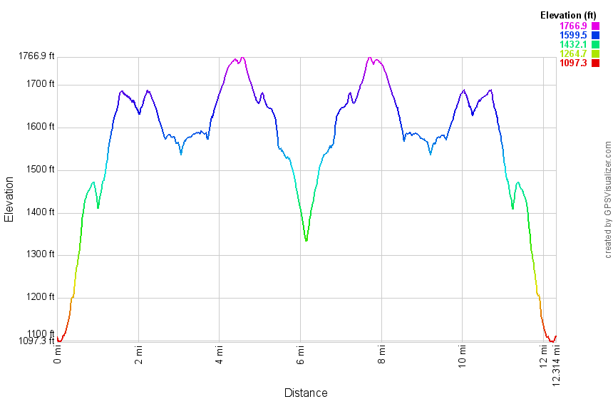
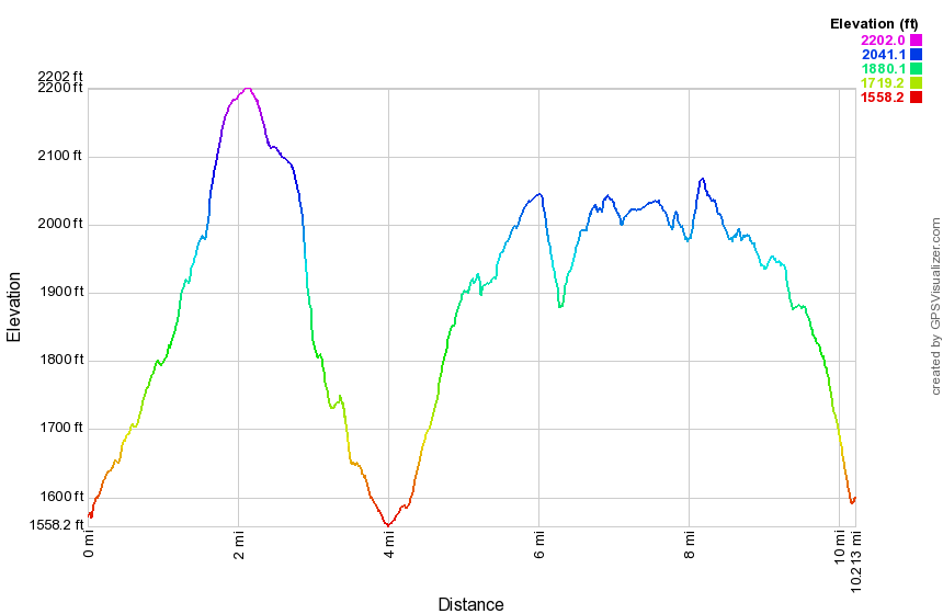 (The image at the left shows the profile of the loop hiking route. Remember that all vertical profiles are relative!)
Finger Lakes Trail: Bully Hill Rd to Hornell
| Quick Look | ||||
|---|---|---|---|---|
| Difficulty | Round trip | Total climb | Internet Maps | |
| 9.7 mi. | 1600 ft. | AllTrails | ||
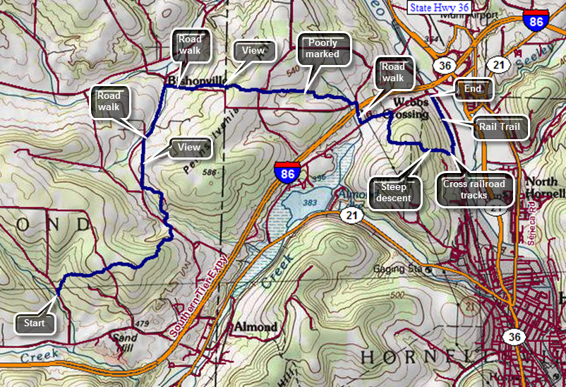
This hike starts where the trail crosses Bully Hill Rd and continues to the parking area on Route 66 near the railroad tracks west of Route 36 in Hornellsville. It covers the last 9.7 miles of FLT Map 9. This requires a car spot or shuttle or a taxi. You may be able to get a ride from a "trail angel" through the Finger Lakes Trail Conference but many are only available on weekends. Village Taxi in Bath charges what I consider reasonable fees so that you can park your car on Route 66 at the railroad tracks and have them take you to Bully Hill Road for the beginning of the hike. Take exit 34 off I86 west (State Route 17) to Hornell. After getting off the exit turn right on Route 66 and drive west to the railroad tracks to a parking area on the left. Leave one car here or have someone pick you up at this spot. Drive back out to I86 and head west one exit to Almond. After getting off the exit turn left or west on Route 2. Drive west 1.5 miles to Bully Hill Road on the left. Turn left and drive .7 miles north to where the trial crosses the road. The trail begins to climb immediately although not too steeply and it parallels a stream which is often dry. The trails are well maintained and well marked. At 1.0 mile cross Karr Road and continue on an old woods road on the other side. The trail is well-marked and level. The trail starts to descend traveling east and ENE toward Bishopville Road. The trail descends steeply at times following an old barbed wire fence until it reaches Bishopville Road at 2.1 miles. You will have lost 440 feet since the top of the hill and will regain some of that along the hike. Turn left on the road and walk north crossing a creek on a road bridge. Just passed the bridge there is an FLT sign and some white blazes but the trail. We push through the weeds until the trail enters the woods where it is more clearly defined. The trail heads north but only for .4 miles where it meets a dirt road used by the highway department. Turn left on the road and continue to walk downhill to the intersection with Bishopville Road and Wilson Karr Road. Make a hard right onto Wilson Karr Road which has a road sign and is PAVED despite the FLT map description stating that it is a dirt road. Walk due north and uphill before starting down the other side. Continue down the hill to Bishopville Road which is not marked with a sign and does not have any FLT blazes! Turn right and start to walk north to Pennsylvania Hill Road. Turn right on Pennsylvania Hill Road which, true to its name, is an uphill climb. After about .4 miles, the trail cuts into the woods on the left. Walk up a little hill into the trees and continue on the trail as it winds through some brush and then begins to climb gently in the woods. At 4.8 miles a path leads to the left to the edge of a field where there is a nice view. Around 5.1 miles cross another woods road or farm lane and continue along a woods road in the forest. Watch for the blazes as the trail almost immediately turns off the woods road to the left. Eventually the trail starts to open up to a field ahead. The trail may be choked with weeds and hard to see but continue walking to the edge of the field. Turn left and walk uphill along the edge of the field following the path to Fitzgerald Road. The trail is direct across the road but the next section may be not well defined or maintained and may be poorly marked in many places. You will come to a field where the blazes indicate a left turn. Turn left and walk along the edge of the field watching for some faded blazes on the left which show that the trail passes through tall grass at the edge of the field and into the woods. Walk in the woods for a while and you will come to another field with no indication of where to go. Walk across the field to the northern edge to a woods road heading east. At 6.7 miles begin to cross some small stream or one stream several times. The FLT map mentions beaver ponds and a electric fence but simply continue on the trail. After the third crossing, walk up a steep bank to Webb Road at 6.8 miles. Turn left on Webb Road and then right on Doorley Road to cross over I86. At 7.2 miles turn left on Route 66 which has a lot of traffic. Walk uphill on the shoulder to the top of a small hill and then down the other side to 7.6 miles. Cross the road to head south on what the FLT map describes as a tractor lane. This lane may be covered in weeds making the climb even more difficult. At 8.0 miles the trail enters the woods which eliminates the weed problem and turns east. It continues to climb reaching a little over 1700 feet at 8.25 miles. From the high point the trail descends for .7 miles to the railroad tracks. The elevation drop is 540 feet which makes the descent rather steep. Just before the railroad tracks, the trail opens up some and there may be weeds, brush and briars obscuring the trail. Crossed the tracks carefully turn left on the rail trail to walk back to the car. The rail trail follows the railbed of the old Pittsburg Shawmut and Northern RR for .7 miles back to the parking area near Route 66.
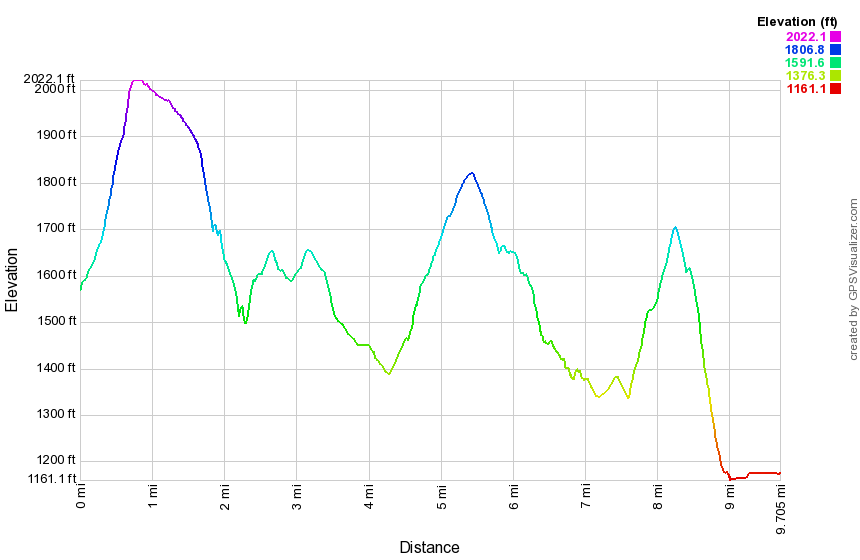 (The image at the left shows the profile of the loop hiking route. Remember that all vertical profiles are relative!)
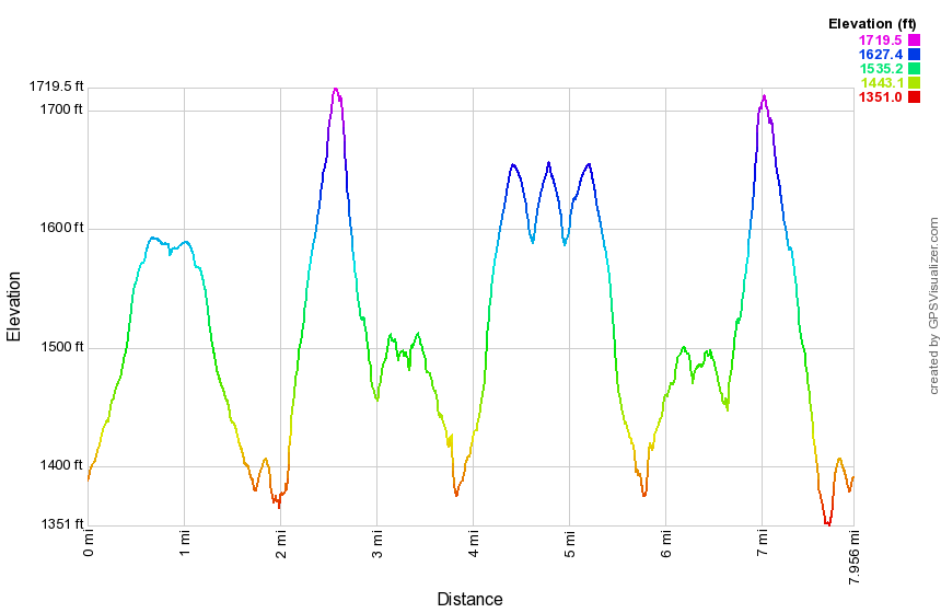
Finger Lakes Trail: Bishopville Rd to Webb Rd
| Quick Look | ||||
|---|---|---|---|---|
| Difficulty | Round trip | Total climb | Internet Maps | |
| 8.0 mi. | 1560 ft. | AllTrails | ||
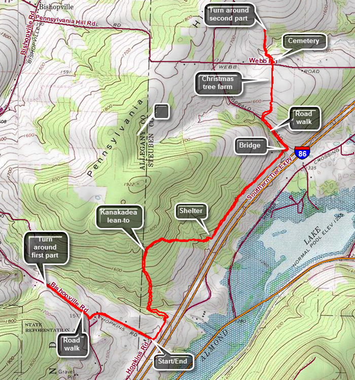
This hike is an out and back hike of a section of the FLT that replaces another section to eliminate a road walk and to visit the Kanakadea lean-to. This section opened after I hiked the original section. Those hiking after 8/20/17 will only hike this new section and may do it as part of a longer hike. There is no parking where the trail meets Bishopville Road and the best parking is at the corner of Hopkins and McIntosh Roads near Almond. Get off I86 at exit 33 westbound for Almond. Turn left off the exit onto Route 2 and then left onto Bishopville Road. After a short distance turn right onto dirt McIntosh Road and drive to where it ends at the intersection with dirt Hopkins Road. You will see the Finger Lakes Trail as it leaves the road and heads toward the right-of-way for I86. Begin the hike at 8:00 AM by walking .5 miles north on Hopkins Road and then turning right on Bishopville Road. Hike another .4 miles to where the trail meets the road.Turn around a hiked back downhill to the car.Continue the hike by following the trail though some grass toward I86. Walk down a short, steep bank to a wide trail cut next to the I86 right-of-way which opens up into a field. After passing through the open area, enter the woods. Just before two miles begin to descend a series of switchbacks to a small stream which is the lowest point on the hike. Parallel the stream for a little while and then begin to ascend the bank on another series of well-planned switchbacks. At 2.2 miles you will be at the Kanakadea Lean-to with a fire pit out front and an outhouse in back. The lean-to is large but the front is very high off the ground requiring a ladder to enter. You are now walking through Kanakadea County park, a park maintain by Steuben County. The park borders Canacadea State Forest. The trail flattens out a little but only for a short distance when a long descent begins and lass for .35 miles and losing 240 feet. Even though the park has existing blazed trails the FLT is clearly marked with white blazes. Just before 3o0 miles, descend to cross another little stream and then ascend the opposite bank. On the left side of the trail is an impressive construction not marked on the map. Someone has collected many branches and placed them between standing trees to create walls on three sides. The shelter is large with some branches supporting a tarp to form a roof. Soon after this you will come to a fence which is the boundary of the I86 right-of-way. Begin a .8 mile section of almost perfectly straight trail heading northeast toward Fitzgerald Road. This trail follows a pre-existing trail as some of the white blazes clearly are painted over older blue blazes. At 3.3 miles cross another stream and where the bank is very steep on both sides. At 3.8 miles there is a small stream with a bridge across it . The bridge was built by a summer BOCES class in 2012. The western end of the bridge is almost suspended in the air as the stream has eroded the dirt supporting it. Cross the bridge and turn left on dirt Fitzgerald Road to begin another uphill climb watching for the point where the trail enters the woods again on the right. Walk about .8 miles north and then follow the trail to the right into the woods. The trail starts to head northeast climbing through the mixed pine and hardwood forest. This section is the one that closes on September 1st but the bypass is to simply walk up Fitzgerald Road and then east on Webb Road. It is a short walk to an open area and then to an open field. Walk along the west side of the field still climbing without benefit of any blazes. There is a large Christmas tree farm on the left. At 4.4 miles start downhill to Webb Road. Crossed Webb Road where there was a cemetery on the right. The trail descends through some hardwoods to a wetland crossed by several streams. The banks of the streams are almost vertical and there were no bridges to cross. Continue through the woods along a woods road until the trail turns abruptly to the right. This is the end of this "new" section. Turn around and follow your route back to the car.
 (The image at the left shows the profile of the loop hiking route. Remember that all vertical profiles are relative!)
| Quick Look | ||||
|---|---|---|---|---|
| Difficulty | Round trip | Total climb | Internet Maps | |
| 10.2 mi. | 1400 ft. | AllTrails | ||
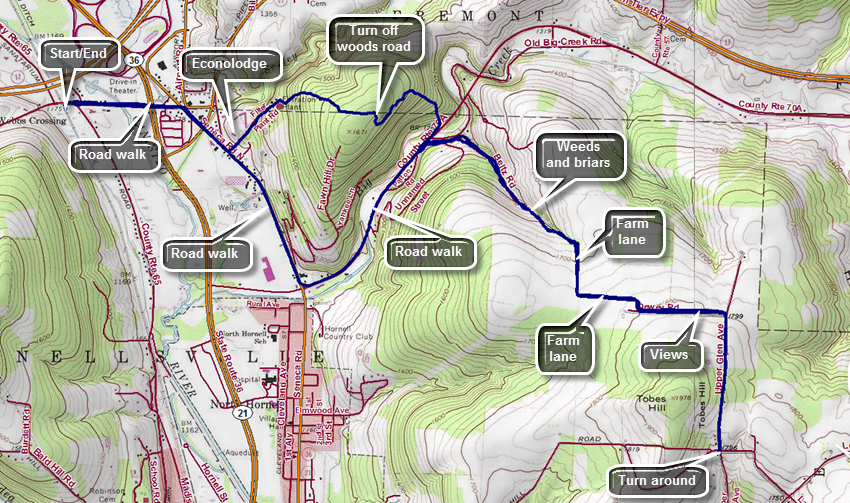
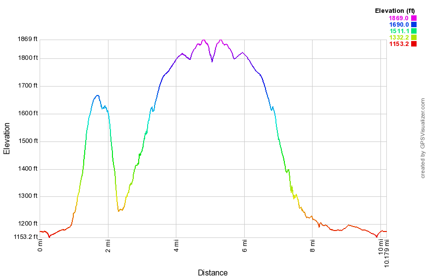
This hike starts at the parking area on Route 66 near the railroad tracks west of Route 6 in Hornellsville. It covers the first 5.2 miles of FLT Map 10! This can be done as a straight out and back hike or the roads can be used on the way back for a different view. Take exit 34 off I86 west (State Route 17) to Hornell. After getting off the exit turn right on Route 66 and drive west to the railroad tracks to a parking area on the left. Begin the hike by walking east on Route 66 to a traffic light on Route 36. Cross the intersection and continued on Route 66 watching for a right turn onto Seneca Road North at the next stop sign. Turn right to walk south along Seneca Road North crossing a branch of the Canisteo River. At .9 miles turn left into the driveway of the Econolodge to hike the section of trail that eliminates the road walk. Walk up the driveway following some blazes on the trees and poles. Continue to the right of the motel on paved road and then up the hill on a dirt road which passes the Hornell Water Filtration plant and a large water tank farther up the hill. Continue up the hill which is challenging but not very difficult. Bear right at the top of the hill. There are places where other roads branch off but the trail is clearly marked. When you hear the top of the hill and the trail levels, watch for a turn to the left. Follow the trail through a bower heading generally northeast and then east through mixed hardwood and evergreen trees. At 1.7 miles you will hit the highest point on this section and will have gained 480 feet in .8 miles. The trail now starts to descend toward Route 70A. After a short descent on the woods road, watch for the trail to turn off the road to the left at 1.8 miles. The turn may not be well marked. When you arrive at Route 70A, turn right to walk down the road. Turn left at the second road which is marked with an FLT sign and blazes. This is Beltz Road and the turn is more than 90 degrees and up a hill. After a short distance the trail turns to the left off the road following an old woods road. The road begins to parallel a streambed and there are wide gullies that seem to have been cut by a lot of running water. There is even a pretty good sized bridge on the trail. The trail has few blazes and there can be blowdowns and branches on the trail. As the woods road opens up weeds and briars may have completely overgrown the trail. Once you are back in the woods the trail is mostly dirt. At 3.5 miles turn right on a farm lane. The lane heads south until 3.7 miles when it turns east. At 4.0 miles it turns south and meets up with Dewey Road. Hiking along the lane and Dewey Road there are some nice views to the north and fields on both sides of the road. Dewey Road meets Upper Glen Road at 4.7 miles. Turn right and walk uphill passed some houses to the highest point on the hike at 4.8 miles. From here walk down Upper Glen Avenue to the intersection with Lain Road at 5.1 miles. This completes the out part of the hike. Turn around and head back up the hill on Upper Glen Avenue retracing your steps to Dewey Road. Continue to the farm lanes through the fields. Turn left into the woods and start back down the hill on the woods road. Going downhill through the weeds is easier than pushing uphill. This failure of electronic devices illustrates why all hikers should carry printed maps and a standard compass. All hikers should also know how to use these two invaluable aids. Continue down the woods road to Beltz Road and hiked down to the intersection with Route 70A at the base of the hill. Turn left onto Route 70A at 7.7 miles. Walk .9 miles west to Seneca Road North and turn right to hike north. The roads have a wide shoulder in most places. Passed the Econolodge, cross the river and at 9.6 miles turn left onto Route 66. Walk back to you car>
 (The image at the left shows the profile of the loop hiking route. Remember that all vertical profiles are relative!)
| Quick Look | ||||
|---|---|---|---|---|
| Difficulty | Round trip | Total climb | Internet Maps | |
| 10.5 mi. | 2244 ft. | AllTrails | ||
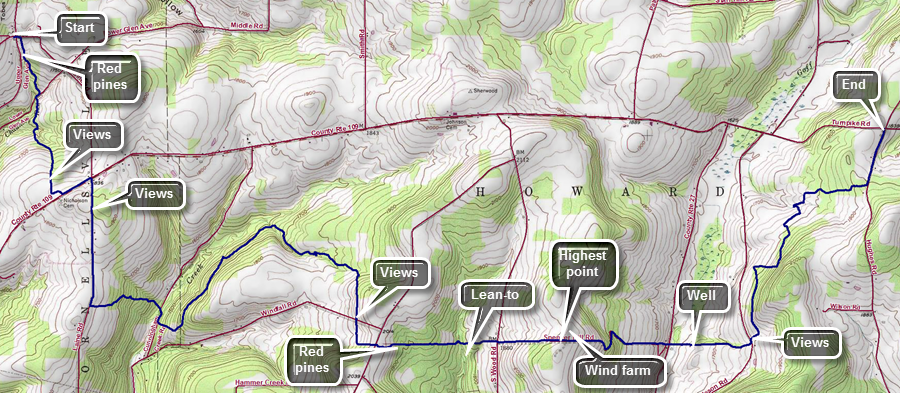
This hike starts at the intersection of Lain Road and Upper Glen Road east of Hornell, NY and covers 10.5 miles of FLT Map 10! This requires a car spot or shuttle or a taxi. You may be able to get a ride from a "trail angel" through the Finger Lakes Trail Conference but many are only available on weekends. Village Taxi in Bath charges what I consider reasonable fees so that you can park your car on Hughes Road and have them take you to the intersection for the beginning of the hike. Take exit 35 from Rt17/I86 to Howard, take Route 27 south from Howard to Turnpike Road (Route 109). Turn left or east and drive less than a mile to Hughes Road. Drop a car here or arrange for a ride to the beginning of the hike. Head west on Turnpike Road for 5.3 miles and turn right on Lain Road. Drive 1.25 miles north to the intersection with Upper Glen Road. The hike starts at this intersection as you hike east on Lain Road for about 150 feet. Watch for the FLT sign on the right and turn into the woods. There is a nice pine plantation here as you hike south toward Lower Glen Road. Cross Lower Glen Road at .5 miles and then start an ascent toward Turnpike Road. You will break out into a field and continue to walk uphill with some nice views to the right at about 1.2 miles. Continue along the edge of the field turning left into the woods just before Turnpike Road. After a brief walk in the pines, you will come out on Turnpike Road. Turn left to walk east to Lain Road and turn right to travel south on Lain Road. Begin to ascend to a hilltop and then continue downhill to the next turn. At 2.4 miles turn left off Lain Road heading east through the woods descending through a hardwood forest. At Cunningham Creek Road you will have dropped 400 feet in .6 miles. The FLT emerges next to Cider Creek Hard Cider in Canisteo. Turn right on the road and walk less than .1 miles to the point where the FLT turns left on an ATV trail. The ATV track is one of the steeper climbs on the hike at 19% but it only lasts about .2 miles. Be sure to watch for the blazes indicating a turn to the left at 3.2 miles. The trail follows Cunningham Creek for about a mile with the creek far below and to the west. At 4.2 miles turn right onto a logging road and start uphill before turning left on another woods road which seems flat at first but is slightly uphill. The trails here may be muddy especially if it has rained and there is active logging in the area. At 4.6 miles the trail seems to continue out of the woods into a field. DO NOT go this way but watch for the blazes indicating that the trail turns off the road to the left. Follow the blazes as they lead through the woods very near the edge of some fields and up toward Windfall Road. This trail may be poorly marked and show little signs of use with almost no track to follow. At 5.3 miles you will come to Windfall Road with some nice views. Cross Windfall Road and walk along the edge of a field until entering the woods and turning left following the trail. Head east and cross Burt Hill Road at 5.6 miles traveling along the northern boundary of Burt Hill State Forest. Walk through another red pine plantation. The trails in this area may be muddy and there can be a lot of roots along the way. The trail begins to descend and at 6.2 miles passes the spur trail to the right to a lean-to. At 6.4 miles cross South Woods Road and continue straight ahead on Spencer Hill Road which is a seasonal use road. At the top of the hill a wind farm came into view and a little farther along there is a small "park" on the right with some signs explaining how the wind farm operates. This is the highest point on the hike. Continue down the hill passing a farmhouse on the left and following Spenser Hill Road until just before it met Stephens Gulch Road. The trail goes off the road to the left following a shady path next to a creek. Watch for animals on the right as you near Stephens Gulch Road. There are horses, goats and a burro in the pastures at various times. Continue down to the road crossing it to a farm lane on the other side. Start up the hill and watch for a well on the right with cold and very refreshing water. Continue up the farm lane until it meets Burleson Road. Turned left and watch for some views straight ahead and some more windmills from the wind farm on the left. Turn right on the trail which follows a path cut through a brushy field until it again enters the woods. From this point on the trail may be poorly maintained and poorly marked. At 8.8 miles the trail comes out of the woods to a junction where paths lead in three directions. To stay on the trail turn right more than 90 degrees and follow the white blazes. Head east walking uphill on a steep but short ascent through the forest. At 9 miles the trail turns north and begins to follow the contour lines so there is less climbing. In about a quarter mile the trail comes out to an open area with mowed paths. Turn left and then right on the paths and walk along the edge of the forest until the path starts to turn right. You should find an opening in the forest on the left and you should turn left even though there may be no blazes visible. After a short distance, there are white blazes marking the trail. At 9.5 miles descend to a small stream where a blaze indicates a right turn. The trail is completely washed out and no blazes are visible on the other side. Cross the stream and head right along the other bank until you pick up the blazes again. The trail turns north briefly and then at 9.6 miles it turns east continuing toward Hughes Road. Wander through the woods trying to find blazes until you make it out to the road at 10.1 miles. Turn left to walk north .35 miles on Hughes Road to your car.
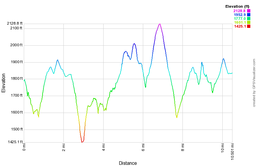 (The image at the left shows the profile of the loop hiking route. Remember that all vertical profiles are relative!)
Finger Lakes Trail: Hughes Rd to Sand Pit Rd
| Quick Look | ||||
|---|---|---|---|---|
| Difficulty | Round trip | Total climb | Internet Maps | |
| 12.2 mi. | 1430 ft. | AllTrails | ||
This hike starts at the intersection of Hughes Road and Turnpike Road south of Howard, NY and cover the entire 12 miles of FLT Map 11! This requires a car spot or shuttle or a taxi. You may be able to get a ride from a "trail Angle" through the Finger Lakes Trail Conference but many are only available on weekends. Village Taxi in Bath charges what I consider reasonable fees so that you can park your car on Sand Pit Road and have them take you to the intersection for the beginning of the hike. Take exit 38 from Rt17/I86 to Bath, turn right and then left onto Route 415 heading northwest. After just less than a mile, turn right on Spaudling Drive and then right on Harrisburg Hollow Road at the end. After .4 miles, turn right on Sand Pit Road and park at the wide spot on the road just below or above the point where the Finger Lakes Trail crosses the road. Drop a car here or arrange for a ride to the beginning of the hike. Head back out to Route 415 and turn right and pass under 17/86. Then left onto Route 15, Knight Settlement Road. After 3.4 miles, turn right on Turnpike Road heading west. Drive about 9 miles passing a wind farm on the left just before the junction of Hughes Road and Turnpike Road. The hike starts at this intersection as you hike east on Turnpike Road down a long hill and up the other side. At the top of the hill on the road it is time to descend the other side to Craig Road at the bottom of the hill. Turn left and walk along one of the few flat spots on the hike. At about 2 miles turn right on McCaddam Road. Despite its name the road soon turns to dirt and ascends a hill between two rows of evergreens. Top the hill and turn left on Harris Hill Road. Walk downhill and at 2.9 miles turn right into the woods. The trail may be a little overgrown as it passes along the edge of a swamp before hitting a farm lane. Follow the lane for a while until the trail turns right into the woods next to the field. The trail comes out onto another farm lane, turns left and continued on it for some time. Crossed Route 69 and begin another short ascent and then begin to walk along the top of a small ridge between two stream beds. Eventually the trail drops down to another woods road. As you approach Snell Hill Road there is an archery range on the left in the woods. Walk out to the road and turn left and then right into the woods again. The trail passes through some woods between fields before finally breaking out into some fields. Follow the blazes as the trail descends to Gay Gulf Road. Turn left here and hiked downhill a little to a bridge across a stream. The trail turns into the woods and begins a slight ascent up a hill. After a short walk in the woods you will to a field where you can walk the edge near the hedgerow to get up to Robinson Road. Cross Robinson Road and head for a lone tree in the middle of a field. The trail continues along a hedgerow which is surprisingly well marked. Follow the trail through the fields by hugging the edge of the fields. The trail eventually enters the woods again. Begin a descent of over a mile dropping 360 feet to Sinclair Road. Turn left and walk out to Campbell Creek Road. Head left or north on Campbell Creek Road dropping another 100 feet. At 7.8 miles turn right onto Cochran Road and get ready for an ascent up a significant hill. At the highest point on the hill you will have hiked about .9 miles and gained 450 feet. Keep walking on the road until at 8.8 miles the road makes a 90 degree turn right and an FLT sign on the corner indicates the trail enters the field. The blazes are well-placed and visible. Follow them as they follow the hedgerow. At one point the trail passes through the hedgerow to the other side descending all the way. At the end of the fields follow the blazes slightly uphill to the left and then turn to follow them to the right under the powerlines. Descend to Knight Settlement Road after hiking 9.5 miles. The trail crosses the road and parallels it for a short distance. This section is closed for hunting season and the bypass is to simply walk down the road. Turn left on Knight Settlement Road being careful of the traffic which can be heavy on a road with a narrow shoulder. After about half a mile the shoulder widens. The road is a gentle downhill for 1.6 miles to Route 415 and passes over the railroad tracks and runs by Knight Settlement Sand and Gravel. Carefully cross Route 415 and turn right. In a short distance turn left on Spalding Drive and continue straight ahead at the next intersection on Harrisburg Hill Road. Turn right on Sand Pit Road and walked up hill to the car.
 (The image at the left shows the profile of the loop hiking route. Remember that all vertical profiles are relative!)
Finger Lakes Trail: Sand Pit Rd to Rt 13
| Quick Look | ||||
|---|---|---|---|---|
| Difficulty | Round trip | Total climb | Internet Maps | |
| 13.6 mi. | 2150 ft. | AllTrails | ||
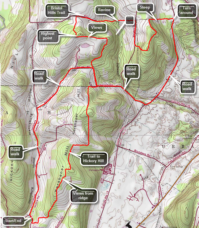
This hike starts on Sand Pit Rd NW of Bath, NY. The route described here is only one way to approach the hike and uses local roads on the return trip. Take exit 38 from Rt17/I86 to Bath, turn right and then left onto Route 415 heading northwest. After just less than a mile, turn right on Spaudling Drive and then right on Harrisburg Hollow Road at the end. After .4 miles, turn right on Sand Pit Road and park at the wide spot on the road just below the point where the Finger Lakes Trail crosses the road. Walk up the road and turn left into the woods and immediately begin to climb. Head northeast for about 1.4 miles gaining almost 500 feet and watch for some nice views as the trail alternates between woods and fields. The trail is wide and well kept following woods roads in many places and breaking out into corn fields. The views from the fields are nice but not spectacular. At 1.7 miles pass by a small pond with structure on its southern shore. Turn right and walk down the spur trail to the shores of the pond. Continuing on this trail takes you to the Hickory Hill Campground. Return to the main trail making a right turn and arriving at the Hickory Hill leanto at about 1.8 miles. The leanto has a privy, picnic table, fire ring, and a nice view of some far away hills. The trail continues north as it ascends Kershener Hill at 1820 feet. From the hill begin a descent to Robbins Road at 3.1 miles. Turn left and walk up Robbins Road for about .3 miles and then turn right into the woods. Walk along the woods road and try to find your way using the FLTC unusual trail blazes. Eventually the trail breaks out into a field and continues around the edge. You may notice an interesting set of wooden stakes on a hill in the middle of the field. Continue to walk around the field and you may see a little hut just off the trail. The structure has four partitioned stalls with a small bench in each one but the function is not clear. Continue to follow the road along the edge of the field and you will begin to get some nice views to the left. The road ascends a little hill and the views get better. Along the side of the trail are two stone benches so that hikers can enjoy the views. This is the highest spot on the hike at 1900 feet. Continue to walk along the trail on the road and turn right into the woods. There is a sheltered bench called the "Puckerbush Overlook" just inside the woods. Continue on the trail following a woods road as it passes by some houses and then comes to Ferris Road at 5 miles. Turn right and follow the road down hill and due east until it eventually becomes a woods road. The trail follows the road for some time and then enters the woods only to come back onto the road. At 5.3 miles the Bristol Hills Branch Trail heads north. The road is very eroded and hard to walk in some places. Descend to a deep ravine and follow the trail down into the ravine and across it. The ravine which was cut by Softwater Creek but now is completely dry. Walk up the opposite bank which is steep but within .3 miles you will come to Newton Road. Turn right on Newton Road and walk downhill for about .4 miles on packed and the loose dirt and gravel. The trail then turns into the woods to the left and begins to climb again. The climb is steep averaging 16% even with the switchbacks but it is only .3 miles to the top of the hill. The trail has been heading east but at the top of the hill it turns north and immediately begins a descent on a woods road. This is gentle at first but at 7.3 miles the trail turns east again and begins a steep descent to Route 13 at 7.7 miles. At Route 13 turn right and begin to WA south. At 9 miles pass Cold Spring Road on the left and at the top of the hill turn right on Robbins Road and begin the hike over the ridge. At 10.2 miles you will be on the section of Robbins Road that you hiked earlier. This time hike up the hill and then continue on the road instead of turning into the woods. Walk downhill for a pleasant 1.25 miles. Near the Harrisburg Hollow Road the surface is paved which makes walking easier. At the intersection on the right side of the road is a strange structure. It is very tall and thin with a door and three stained glass windows with a cross on the side. Continue the hike by turning left on Harrisburg Hollow Road and walking south. Walk the final 1.8 miles downhill and south on the road. Turn left on Sand Pit Road and walked 300 feet uphill to your car.
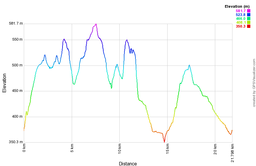 (The image at the left shows the profile of the loop hiking route. Remember that all vertical profiles are relative!)
Finger Lakes Trail: Rt 13 to Winding Stair Rd
| Quick Look | ||||
|---|---|---|---|---|
| Difficulty | Round trip | Total climb | Internet Maps | |
| 12.4 mi. | 2100 ft. | AllTrails | ||
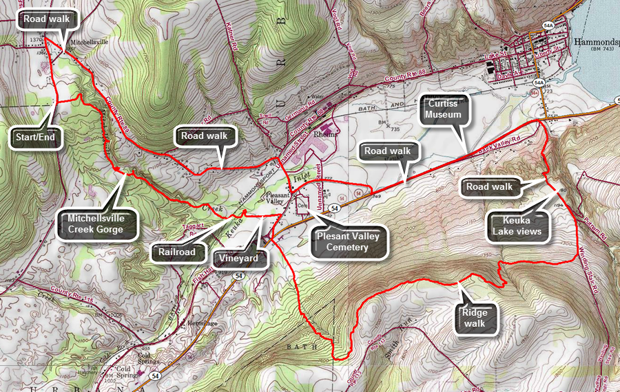
This hike starts on Rt 13 just south of Mitchellsville, NY. The route described here is only one way to approach the hike and uses local roads on the return trip. Take exit 38 from Rt17/I86 to Bath, turn right and then right again onto Route 415 heading east and south. Watch for Liberty Street on the left at a traffic light. Turn left and follow Liberty Street until it bends right and Haverling Street goes left. Bear left onto Haverling Street which become Route 13 north to Mitchellsville. Drive 4.8 miles north to where the Finger Lakes Trail crosses the road. Turn around and park on the wide shoulder on the west side of the road. We crossed Route 13 and walked through a mowed area of a field between two fields of soybeans that looked ready to harvest. The grass was wet and as we entered the shadow of the trees there was still frost on the ground. We came to the trail through the woods and started to walk along the Mitchellsville Creek Gorge. The gorge is mentioned as "very special" on the Finger Lakes Trail map description and several websites tout it as an interesting place. Many of the waterfalls are hidden by trees and are impossible to see. You may be able to get a few glimpses but good views are hard to come by! The depth of the gorge and the rock walls are impressive and it is a nice walk. At various places along the trail paths lead out to precarious viewpoints into the gorge. These are very unsafe and afford few views worth the risk. At about .9 miles the trail opens out into a field. Turn sharply left and walk down to the creek if you would like to see a very small waterfall and have a good view of the gorge walls. Walk back up to the field and turn left and walk along the edge of a field to pick up the trail as it reenters the woods. Continue to descend on the Finger Lakes Trail to an unused railroad track at around 2 miles. Turn left and walk along the track and then a trail to a bridge at 2.2 miles. Walk up to an open field and out to a vineyard. The Finger Lakes Trail follows the edge of the vineyard out to Route 88. At the road turn right and follow it out to the town hall. The trail crosses the lawn and turns right on Route 54 by the Vinehurst Motel. Just passed the motel turn left and walk along a dirt road before the trail continues straight ahead beginning the ascent of a ridge. Strangely, the trail follows one of two parallel woods roads, crosses over to the other, enters the woods on a trail for a hundred feet and then returns to the original woods road! You are now headed south or southeast and over the next .75 miles the trail gains over 700 feet at an 18% grade. The woods are now mostly hardwoods and at one point the trail comes to a field, follows the edge and then reenters the woods. At 3.9 miles the trail begins to turn north, northeast and then east. The trail rolled along the ridge never really attains the highest point. At 5.4 miles it begins to descend and a t 5.8 miles the June Big Trail heads to the north to the Glen Curtiss Museum. Continue to descend on the trail until it reaches Winding Stair Road at 6.4 miles. Turn left and start to descend to the valley. At around 6.9 miles watch for a space to open up on the right side of the road and a dirt road heading off into a field. From this spot there are excellent views of the Keuka Lake. Head down the road to Route 54 arriving at the main road at 7.5 miles. You will have now dropped 1030 feet from the top of the ridge! Turn left and began a long walk along Route 54. Fortunately the road has wide shoulders but watch out for quickly moving traffic. At 8.2 miles you will see the entrance to the Glenn Curtiss Museum with a DC-3 parked in a field. Just after the museum turn right on South Valley Road to get to Route 88 which heads back toward Mitchellsville. Follow the road and as you approach Route 88 watch for the Pleasant Valley Cemetery on the left. This is the resting place of Glenn Curtiss and a sign details his life. Turned right on Route 88 and walk about .3 miles to the intersection with Route 89. Turn left and get ready to regain all the elation you lost coming down into the valley! The road starts to climb almost immediately and it seems like it goes on forever. The valley has an elevation of 800 feet and over 1.35 miles you will climb to 1370 feet where the road levels off. Here Route 88 parallels the Mitchellsville Creek Gorge and across you can look to the trail you hiked when you first started the hike. At 11.9 miles turn left at the intersection with Route 13. Do a little more climbing to get back to the car.
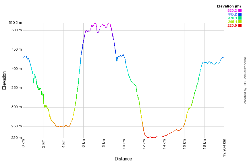 (The image at the left shows the profile of the loop hiking route. Remember that all vertical profiles are relative!)
Finger Lakes Trail: Birdseye Hollow Rd to Winding Stair Rd
| Quick Look | ||||
|---|---|---|---|---|
| Difficulty | Round trip | Total climb | Internet Maps | |
| 12.4 mi. | 1800 ft. | AllTrails | ||
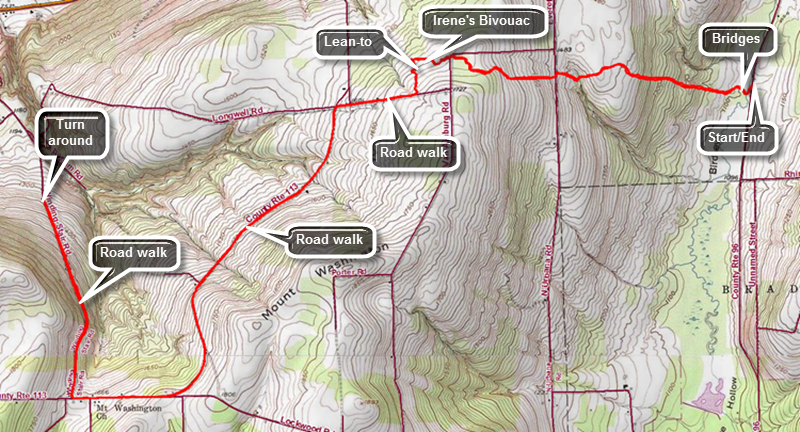
This hike starts on Birdseye Hollow Road just north of Birdseye Hollow County Park in Steuben County, NY. The route described here is a straight out and back with about 8 miles of road walking. Take exit 40 off Rt17/I86 toward Savona and get on Route 226 heading northeast. After about 7.5 miles, turn left on Myers Road which connects to Route 16. Turn left on Route 16 and drive 1.5 miles west to Birdseye Hollow Road on the right. Turn right and drive north for 2.3 miles passing Birdseye Hollow County Park. At 2.3 miles the Finger Lakes Trail crosses the road. Find a place on the shoulder to park. Walk west into the forest into the forest. The trail almost immediately crosses a stream on a set of two bridges. Walk through mostly hardwoods and be prepared to climb up to the top of a ridge. Over the first .9 miles the trail gains 375 feet with an average grade of 8%. At least the last part of the return trip is downhill! At 1.2 miles the trail crosses Urbana Road with a slight jog to the south. The land on the other side of the road is private property but the owner allows hikers on the trails. The trail here is a wide lane but there are several that cross each other so watch carefully for the blazes. The trail continues to climb and at 1.8 miles it crosses VanAmburg Road. At 2 miles there is a directional sign at the site of Irene's Bivouac. Just passed this area is a leanto. Continue on the trail passing the leanto and at 2.25 miles arrive at Longwell Road. The trail now follows local roads to the turn around point on Winding Stair Road. Turn right on Longwell Road and walk a short distance downhill to Route 113. Turn left to head southwest and watch for traffic as the road can be busy. The road rolls quite a bit and is more up hill than down for some time. Continue to the intersection with Lockwood Road on the left walking passed it to continue toward Winding Stair Road. Winding Stair Road turns right after a descent and just at the base of a long hill. After turning right, start walking down the road. Walk north losing elevation every bit of the way until you have dropped 350 feet to where the Finger Lakes Trail comes out of the woods on the left. Turn around here and start back up Winding Stair Road. Since this hike is out and back simply retrace your steps to get back to your car. Fortunately the reverse direction looks a little different. There may be some opportunities to take other routes but these involve dropping off then ridge and then climbing back up!
 (The image at the left shows the profile of the loop hiking route. Remember that all vertical profiles are relative!)
Finger Lakes Trail: Birdseye Hollow Rd to Rt 226
| Quick Look | ||||
|---|---|---|---|---|
| Difficulty | Round trip | Total climb | Internet Maps | |
| 11.9 mi. | 885 ft. | AllTrails | ||
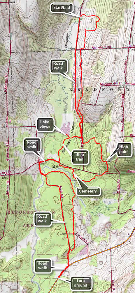
This hike starts on Birdseye Hollow Road north of Birdseye Hollow County Park. The route described here is only one way to approach the hike and uses local roads on the return trip. The county park is well worth seeing! Take exit 40 to Savona and get on Route 226 heading northeast. After about 7.5 miles, turn left on Rabbit Road which connects to Route 16. Turn left on Route 16 and drive 1.5 miles west to Birdseye Hollow Road on the right. Turn right and drive north for 2.3 miles passing Birdseye Hollow County Park. At 2.3 miles the Finger Lakes Trail crosses the road. Find a place on the shoulder to park. Cross the road and walk a little south before entering the woods to start east on the trail. The forest is an interesting mix of red pines and deciduous trees and the walk is pleasant if not particularly scenic. The trail seems to be well marked but there may be a few blowdowns blocking the trail in places. At .35 miles the trail turns south but then turns west before turning south again and crossing Rhinehart Road at 1 mile. Walk a little farther and watch for the bench dedicated to Mary Years on the left. Across from the bench is the foundation of an old farmhouse and a sign explaining a little bit about the history of the area. The trail continues south following an old woods road until 1.75 miles when it branches off the road to the right and begins to descend off the ridge. The trail has been running parallel to the road and now descends to the intersection of Munson Hollow Road and Birdseye Hollow Road at 2.1 miles. Cross the roads and follow the white blazes for the Finger Lakes Trail and the blue blazes for the park trail. At 2.4 miles there is a T in the trail where the Finger Lakes Trail turns left and the blue park trail turned right. Follow the blue blazes of the park trail as it is an "approved" shortcut. The trail comes to an area where there was a parking lot and a pavilion. The blue blazes on the trees clearly show that the trail crosses the parking lot and follows a paved walkway south of the lake. Continue on the paved path and notice lake on the right with some interesting trees and some small islands. The upper reaches are more of a wetland than a lake or pond and many dead trees are evident. You will come to a wooden causeway that spans the outlet of the lake. The middle of the bridge has a covered section. Walk across the bridge to the shore of the lake to get some nice views. When you are done, return to the blue trail as it crosses an open area and then enters the woods. The blue trail is clearly marked and very nicely maintained. There may be wet spots along the trail in wetter seasons and these are marked by the word "Wet" painted next to a set of blazes. You will soon arrive at Route 16. Turn right and followed Rt 16 toward Aulls Road making a left when you get there. Walk along the road and cross Mud Creek on a road bridge. Just beyond the bridge turn into the woods off the road following the trail. The trail heads east paralleling Mud Creek and at 4.4 miles the creek turns more to the east and the trail heads almost due south and back toward Aulls Road. At 5 miles cross the dirt surface of Dumak Road and walk another .3 miles to Aulls Road. Turn left on the road and walk out toward Route 226. At Route 226 turn right and walk a short distance to where the trail again enters the woods. Turn around here to begin the hike back to the car. Continue to walk the gravel surface of the road north toward Route 16 . At 7.7 miles turn right on Route 16. As you approach the point where you came out onto Route 16 from the blue shortcut trail, turn right into the woods on the main Finger Lakes Trail. The trail runs parallel to Route 16 for about .3 miles heading east and just before it turns south there is an old cemetery. The cemetery is mowed and trimmed but many of the stones are skew and some are toppled from their bases. Back on the trail begin to head a little south and start to climb the only really significant hill on the whole hike. Crossed Route 16 at 9 miles as the trail continues to climb up a ridge to a hike high point of 1280 feet. From here begin to descend rather quickly and at 9.7 miles the trail turns east and comes to Birdseye Hollow Road. Turn right or north and start back toward the car. In a short distance you will come to a left turn that leads back to the T in the trail where you turned onto the blue trail earlier. Follow the trail to the T and turn right to walk back out to the road. Turn left and head north on the road toward you car.
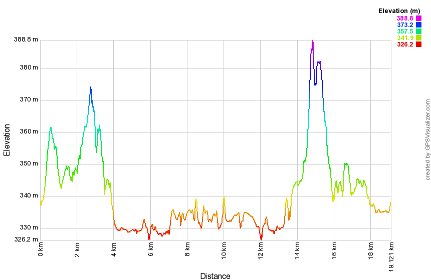 (The image at the left shows the profile of the loop hiking route. Remember that all vertical profiles are relative!)
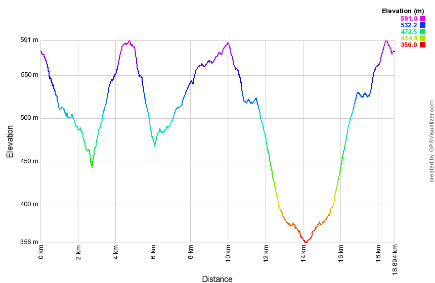
Finger Lakes Trail: Rt 226 to Sexton Hollow Road
| Quick Look | ||||
|---|---|---|---|---|
| Difficulty | Round trip | Total climb | Internet Maps | |
| 11.6 mi. | 1885 ft. | AllTrails | ||
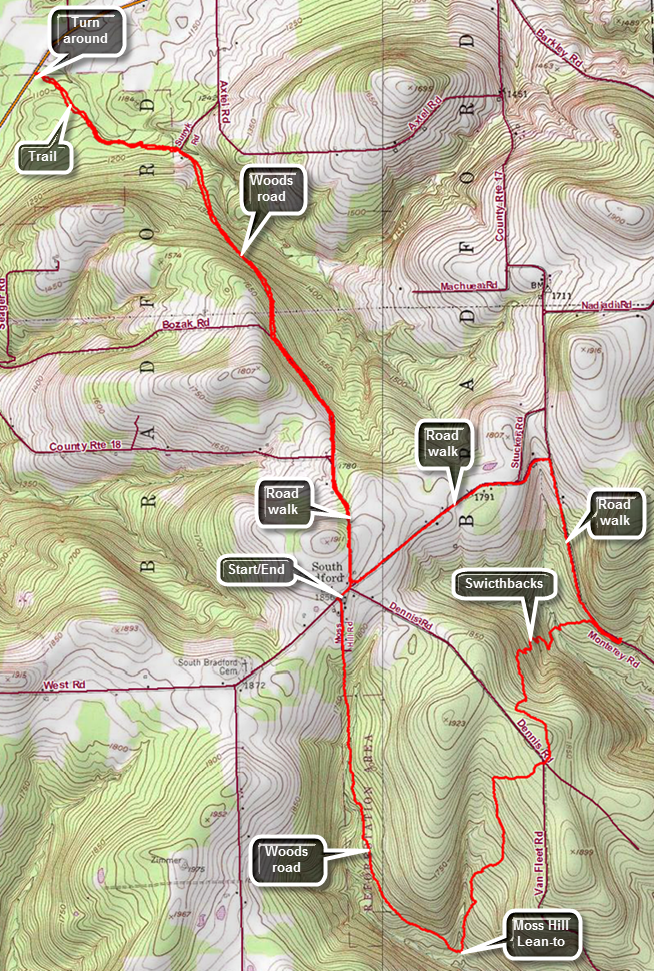
This hike actually starts on Route 17 near Moss Hill Road and makes a southern loop to Sexton Hollow Road and the returns to Route 18 to continue the Finger Lakes Trail to Route 226. If you are sure you can make the 11.6 miles, simply park where the trail crosses Route 226 and do the hike from there. Take exit 41 from Route17/I86 and turn right. Turn left on Clawson Road which shortly becomes County Route 17. After 6.6 miles, Moss Hill Road will be on the right but the shoulder is marked with NO PARKING signs. Turn around and park on the opposite side of the road as there are no signs there. Cross Route 17 to Moss Hill Road and begin to hike south on the paved surface. After only a short distance the pavement ends and the trail continues on a woods road. This road was obviously once part of Moss Hill road but is now abandoned. The trail follows the road and then veers off only to return several times. The blazes on this section of trail are very clear. There isn't much to see on the hike but the walk is all downhill as the trail heads south to the Moss Hill Lean-to. After 1.7 miles, you will be in the area of the lean-to after dropping 490 feet. A short spur trail leads to the lean-to and the blazes for the Crystal Hills Branch Trail are also visible. Of course, every descent has an ascent and the trail begins to ascend from the lean-to heading generally north and east. Again, there are no views or specific attractions. At 2.8 miles cross Dennis Road which has a dirt surface after gaining back 470 feet of elevation. The trail then begins to descend again heading for Sexton Hollow Road. At 3.4 miles the trail begins to head east rather than north and also descends a rather steep grade. There are several switchbacks that help make the descent easier. There are many side paths and woods roads in the area but the marking remains good throughout. At 3.8 miles cross a generally reliable stream. At 4 miles, you can see Sexton Hollow Road. The trail parallels the road for a short distance until it crosses the road. This is the end of the first section of the Finger Lakes Trail on this hike.
Turn left and walk .85 miles north on Monterey Road gaining elevation until you turn left on Route 17. Walk about a mile back to the intersection with Route 18. Turn right and walk a little more uphill on Route 18 to a sort of viewpoint to the south and east. The road starts to descend and at 6.6 miles turns sharply left. The trail continues straight ahead on Bozak Road which is labeled as "Seasonal Maintenance" but looks more like "No Maintenance". The gravel road starts to descend and at 7.2 miles it turns left while the trail turns right onto a woods road through the forest. The trail is still descending which means the return trip will be mostly uphill. At about 8 miles the trail comes out onto pavement near Sutryk Road but the trail almost immediately turns left back into the woods. Follow the trail as it continues to descend toward Route 226. This part of the trail is one of the few places where it does not follow a woods road of some kind. At 8.8 miles the trail crosses Route 226 which happens to be the lowest point on the hike. Turn around and retrace your route ascending all the way back to Route 18. Walk back to the intersection with Route 17, turn right and find your car a few hundred feet away.
 (The image at the left shows the profile of the loop hiking route. Remember that all vertical profiles are relative!)
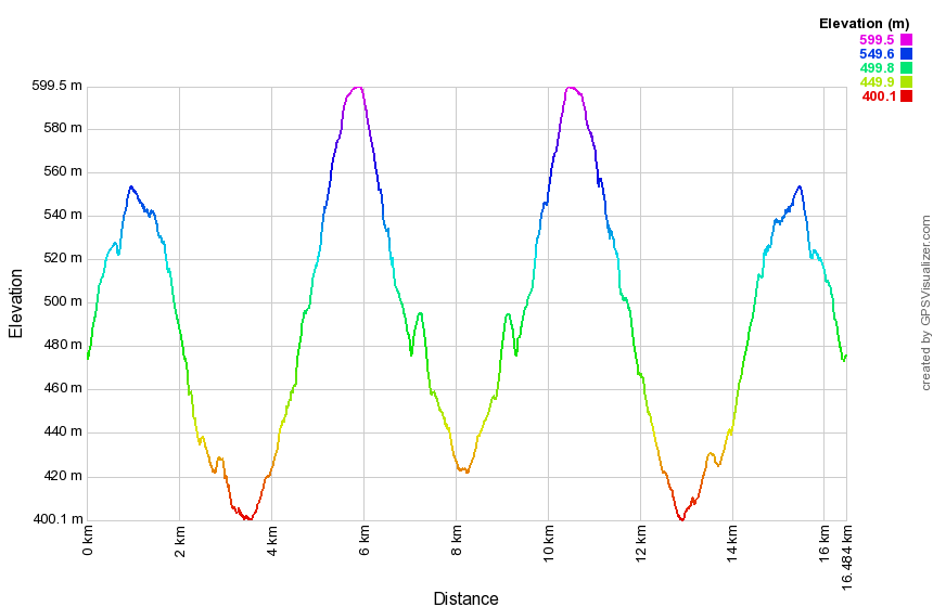
Finger Lakes Trail: Sexton Hollow Road to Switzer Hill Road
| Quick Look | ||||
|---|---|---|---|---|
| Difficulty | Round trip | Total climb | Internet Maps | |
| 10.2 mi. | 2270 ft. | AllTrails | ||
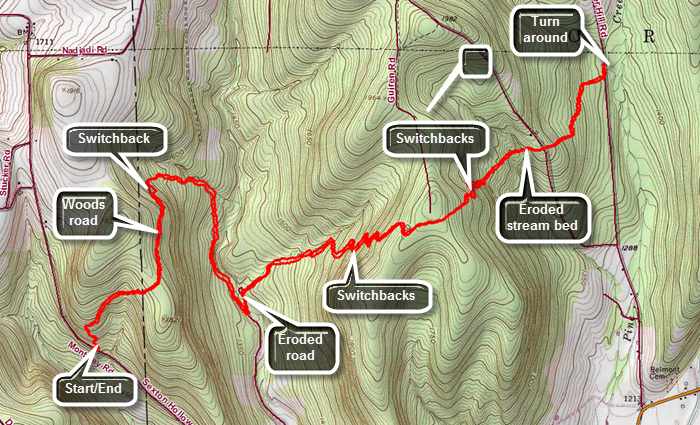
Take exit 42 from Route17/I86 and turn right or northeast on Route 16 toward Monterey. After 7.6 miles, turn left on Sexton Hollow Road which turns to dirt and gravel and then back to pavement. Watched for FLT signs just after the road became paved again and changes names to Monterrey Road. Pull over on the shoulder of the road just passed the trail entrance and made sure you are off the pavement.
Walk south on the road to the trail entrance and head northeast up the hill. The first part of the trail heads northeast and climbs a hill for .6 miles gaining 275 feet with several switchbacks along the way. Continue down the other side of the hill on a woods road which heads north. Watch for a turn to the right onto a switchback at about 1 mile. The switchback crosses the woods road several times At 1.1 miles the trail turns east and then at 1.5 miles it turns south. Along the way it crosses a few small stream that may have some water. At one point the trail empties out onto a gas well access road. Turn left and walk uphill on the road briefly before turning left into the woods again. At around 2 miles the trail parallels a stream bed for some time and approaches Corbett Hollow Road. Walk down to Corbett Hollow Road at 2.1 miles and made a sharp left turn. The road isn't much of a road as it is dirt with a lot of grass which becomes more and more eroded the further you go. Watch for the turn to the right off the "road" and enter the woods to continue the hike. The Finger Lakes Trail map description indicates a bivouac site north of the turn at the turn around point on the road. The next section of trail has 12 switchbacks to make the climb up the hill easier by making the grade smaller. Walk along the trail next to a stream bed and then start the first switchback at about 2.6 miles. Over about 1.3 miles from Corbett Hollow Road to the top of the climb the trail gains 640 feet averaging a 10% grade. At the top of the climb cross a gas well access road and walk the flat summit before starting to descend the other side. Descend the east side of the hill for about .7 miles losing 400 vertical feet to a small stream bed. The stream bed is highly eroded and it is difficult to climb the opposite bank. On the other side is a set a steps and a switchback that led to Goundry Hill Road. Cross the dirt and gravel road and continue to descend through a mixed hardwood and pine forest. At 5 miles the trail comes to Switzer Hill Road at an elevation of 1390 feet. Turn left and walk a short distance north to the point where the trail reentered the woods. This is the turn around point. The hike is a true out and back so turn around and retrace your route back to your car on Sexton Hollow Road. You may appreciate the switchbacks more on the way back!
 (The image at the left shows the profile of the loop hiking route. Remember that all vertical profiles are relative!)
Finger Lakes Trail: Maple Lane to Switzer Hill Road
| Quick Look | ||||
|---|---|---|---|---|
| Difficulty | Round trip | Total climb | Internet Maps | |
| 11.5 mi. | 1825 ft. | AllTrails | ||
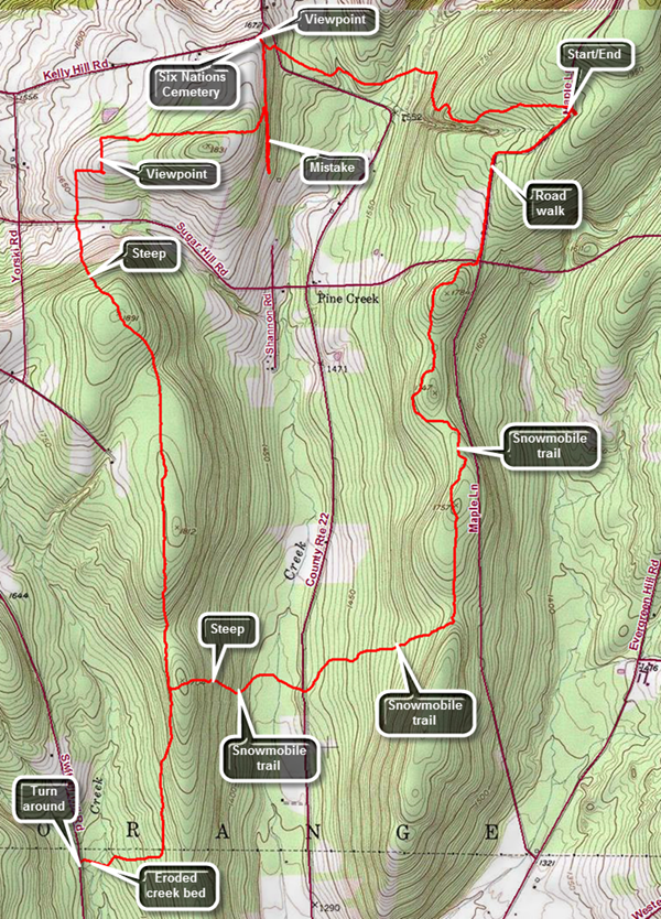
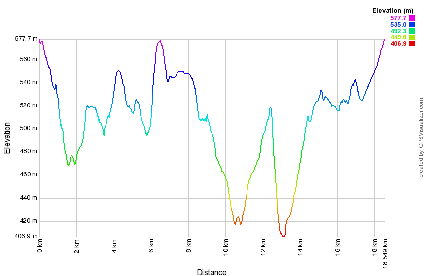
Drive south from Watkins Glen on Route 414 for 1.5 miles and then turn right and drive west on CR-16 for 5.1 miles to CR-21. Turn right and head north for 1.2 miles where CR-21 turns left. At the next intersection where Cr-21 turns right continue straight ahead on Sugar Hill Road which veins as paved and then turns to gravel. Drive 2.1 miles to Maple Lane and turn right. Drive .75 miles north to the parking area on the right.
Walk out the access road to the parking area and cross Maple Lane to head out on the trail. The first part of the trail wanders west through some red pines and then hardwoods all the while descending until it crosses a DEC dirt road at .9 miles. A downhill at the beginning of a hike feels good but means there will be an uphill at the end! The trail turns a little north and then west again as it continues to descend. The trail crosses two branches of Meads Creek which may have very little water in them. After crossing the second creek the trail begins to ascend and crossed Route 22 at 1.5 miles. The trail ascends steeply for a short time before meeting a woods road at 1.6 miles. The trail turns to the left but turn right and walk a short distance to the very old Six Nations Cemetery where there is a spectacular view to the northwest over Lake Lamoka and Lake Waneta. The stones in the cemetery are very old, hard to read and in very poor shape. Walk back to the Finger Lakes Trail which now follows a woods road slightly downhill and to the south. There are no marks or blazes anywhere to be seen but watch carefully for a turn off the woods road which occurs at right around 2 miles. The trail turns west and starts up a steep but short climb over a small hill. Hike down the other side of the hill and eventually the trail breaks out into a field. The blazes can be hard to find and require sharp eyes as there are several turns along the edges of different fields. Many of the blazes are old and the brush has overgrown them making it difficult to find the way. There is a nice view over the surrounding valleys from the high point in the fields. Finish the descent along the edge of a field and follow a woods road out to Sugar Hill Road at 3.1 miles. Just ahead on the other side of the road is a very large oak tree. From this point the trail heads due south and is very straight for some time. The trail ascends to a ridge following a woods road and is wide, well maintained and decently marked. On the initial climb you will gain 260 feet in .4 miles along a 13% grade. After this, the trail descends a little and then levels moving off the road and back onto it. You will pass one well marked snowmobile trail on the left. The trail starts to descend and at 5.1 miles another snowmobile trail appears on our left. This is the one you will use on the return trip Continue straight ahead as the trail continues south and descends off the ridge toward Switzer Hill Road. At 5.75 miles the rail turns west and continues to descend to Pine Creek. The bank here is highly eroded and you may have to look for a spot to cross safely. After crossing the creek walk out to Switzer Hill Road at 6.1 miles. Turn around and retrace your route back across the creek and up to the snowmobile trail at 7.1 miles. Turn right on the snowmobile trail and start a short ascent before the trail begins a half mile descent toward Route 22. The descent is steep at 13% and the trail descends almost 350 feet along the way. At 7.6 miles cross a bridge over Meads Creek walk out to Route 22. Cross the road and stay on the snowmobile trail heading toward Maple Lane. As you head northeast the snowmobile trail starts to climb to another ridge. The climb is not difficult but went on for .7 miles. At 8.4 miles you will come to a junction where you can turn right or left. Turn left or north on the snowmobile trail which parallels Maple Lane and heads north toward Sugar Hill Road. Do not be concerned when the trail wanders some as it will get you where you need to go. At about 10 miles the trail turns northeast and then east and parallels Sugar Hill Road until it comes to the intersection of Sugar Hill Road and Maple Lane. Cross Sugar Hill Road and begin to walk up maple Lane for .8 miles to the parking area.
 (The image at the left shows the profile of the loop hiking route. Remember that all vertical profiles are relative!)
Finger Lakes Trail: Maple Lane to Templar Road
| Quick Look | ||||
|---|---|---|---|---|
| Difficulty | Round trip | Total climb | Internet Maps | |
| 10.5 mi. | 1596 ft. | AllTrails | ||
Drive south from Watkins Glen on Route 414 for 1.5 miles and then turn right and drive west on CR-16 for 5.1 miles to CR-21. Turn right and head north for 1.2 miles where CR-21 turns left. At the next intersection where Cr-21 turns right continue straight ahead on Sugar Hill Road which veins as paved and then turns to gravel. Drive 2.1 miles to Maple Lane and turn right. Drive .75 miles north to the parking area on the right.
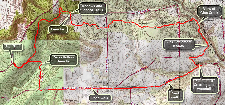
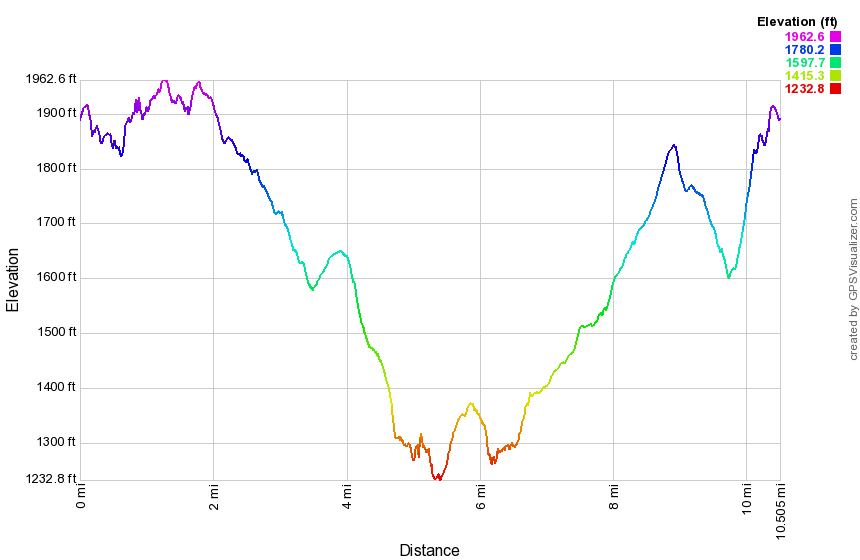
Walk out the back of the parking area on the Finger Lakes Trail. The trail passes through a red pine plantation and descends a little. Several unmarked trails cross the Finger Lakes Trail but at .4 miles a blue trail with a "Lean-to" sign heads off to the right. That trail descends to the Parks Hollow lean-to. Follow the Finger Lakes Trail as it stays on contour around a hill. The trail has been heading north and northeast but at 1.7 miles it descends to cross a dry creek bed and then bends back to head first south and then east. At 1.8 miles cross the Mohawk Trail and at around 2 miles there is a sign on the right that indicates another lean-to and a pond. Continue straight ahead on the main trail. After 2 miles the trail turns south but soon swings east descending all the way. At 2.9 miles cross Route 21 where there is room to park along the side of the road. Continue heading east and descending. A caution on the FLT map indicated the stream crossing near the end of this section could be a problem if the water is high so use your own judgment. The Finger Lakes Trail maps suggest a highwater bypass using local roads. As you walk on the main trail you will come to a spot where there is a large pile of fieldstones. The trail up to this point is well-marked and maintained but after this location there are stretches with few blazes. Much of the trail in this area may be overgrown and with a few blowdowns. There are also a series of wooden walkways meant to bridge muddy areas. This section of the trail heads almost due east. Cross the abandoned part of Locust Lane at 4.5 miles but it is hardly recognizable as a road anymore. There is an old foundation in the area. Continue to head east as the trail continues to descend. At 4.8 miles the trail turns south-southeast along Glen Creek. At about 5 miles there is a viewpoint over the creek which can be almost dry when there has been no rain. This creek is the one that cut the gorge Watkins Glen. As the trail starts to turn away from Glen Creek, watch for a solid rock foundation on the left side of the trail. This is also the lowest point on the hike at 1237 feet. At 5.5 miles pass the Buck Settlement lean-to on the left side of the trail. Follow the trail along what looks like an old road and then cross a small stream that once cut a deep bed. Right after the crossing turn left on an old road. The road descends to a branch of Glen Creek where there are some picnic tables at a small waterfall. This is "Ebenezer's Crossing" but the waterfall may be only a trickle in the dry seasons. This stream has the potential of being a difficult crossing during high water. Walk up to Templar Roadand get ready for the road walk back to the car. Turn right on Templar Road which is covered with gravel. The hike on Templar Road is 1.4 miles and all of it is uphill. Continued straight ahead on Route 21 for .4 miles when Templar Road ends walking uphill on paved road. When Route 21 turns right to head north, continue straight ahead on Sugar Hill Road. Hike another .9 miles uphill before the road starts to descend. Walke another .4 miles downhill until the access road for the Perkins Hollow lean-to comes up on the right. Turn right and start to walk down the road. The access road descends to cross a small stream near the new lean-to site. There is a sign that says "To FLT". Walk uphill in the direction it is pointing heading first north and then west climbing the whole way. At about 10 miles the Mohawk Trail heads north toward the Sugar Hill Fire Tower and at 10.1 miles you will be back at the main Finger Lakes Trail. Turn left and retrace your steps from earlier in the day back to the parking area.
 (The image at the left shows the profile of the loop hiking route. Remember that all vertical profiles are relative!)
Finger Lakes Trail: Templar Road to Watkins Glen
| Quick Look | ||||
|---|---|---|---|---|
| Difficulty | Round trip | Total climb | Internet Maps | |
| 9.4 mi. | 1920 ft. | AllTrails | ||
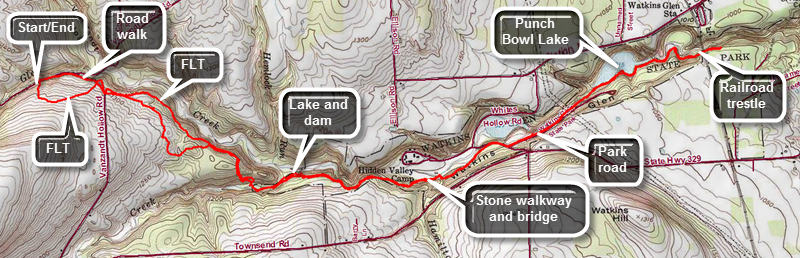
Drive west from Watkins Glen on Route 329 for 5.2 miles being sure to stay right on Route 329 at the intersection with Route 17. As Route 329 turns south, turn right of north on VanZandt Hollow Road. Drive 1.2 miles on VanZandt Hollow Road to the intersection with dirt Templar Road. Turn left and drive .2 miles on Templar Road where the Finger Lakes Trail crosses. Park on the side of the road. Just west of the parking is Ebenezer's Crossing and a small waterfall heavily dependent on rainstorms for its volume.
Cross the road to begin your hike by climbing up the steep bank until the trail levels off. It then descends and crosses VanZandt Hollow Road at .4 miles. The trail enters the woods on the other side for only about .1 miles and then comes back out to VanZandt Hollow Road. Turn left and walk up the hill a few steps to a Finger Lakes Trail sign. Walk off the road and immediately turn left and walk down a path looking for white blazes. This is VRY POORLY marked. DO NOT walked straight ahead off the road and onto the lane next to the farmer's fields as you will be trespassing! The trail here comes back out to a cleared area and then heads to the left back into the trees. Be careful to look sharp as the marking are not obvious. The trail follows a narrow path which may be overgrown by brush and can be poorly maintained. The trail rolls some but at one point comes very close to the edge of the gorge giving good views. Continue on the trail watching carefully for blazes. At 1.2 miles the Finger Lakes Trail crosses the boundary with Watkins Glen State Park although it may not be obvious. At 1.6 miles or so there is a steep descent to the floor of the glen. The trail crosses the stream at 1.7 miles at Julie's Crossing. During the dry seasons there may be no water present at all. After heavy rains or in the spring hikers may want to use the high water bypass marked on the Finger Lakes Trail Map 14. The crossing may not be well marked so you may have top search for the white blazes on the other side of the stream bed. At 2.6 miles watch for Hidden Valley 4H Camp to the right of the trail. Just after this get ready for a surprise. You will find stonework and a stone pathway just like those found in the main glen. A small wooden bridge crosses Hamilton Creek and this is a beautiful place to stop. Continue on the trail as it follows a woods road out to White Hollow Road at 3.1 miles. Turn right on the road and walk uphill a short distance and then turn left on an old park road. At 3.5 miles the trail leaves the road to the left and follows the rim of the gorge until you reach Punch Bowl Lake at 3.9 miles. There is a beautiful picnic pavilion here but there is no potable water, no privy and no camping! Walk passed the lake and you will find a viewpoint that allows you to get a good look at the dam. Continue on the trail to the Norfolk Southern railroad trestle at 4.9 miles. Walk a little farther if you like to make sure you overlap other hikes. The South Rim Trail continues down to Route 329 in Watkins Glen where it crosses Route 14 and follows city streets on the way to the southern end of Seneca Lake. Turn around and follow the trail back to your car. There don't seem to be any shortcuts on local roads unless you need the high water bypass.
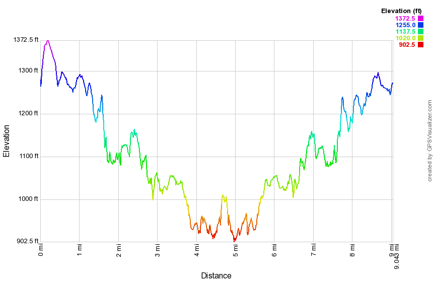 (The image at the left shows the profile of the loop hiking route. Remember that all vertical profiles are relative!)
Finger Lakes Trail: Watkins Glen State Park (South Rim)
| Quick Look | ||||
|---|---|---|---|---|
| Difficulty | Round trip | Total climb | Internet Maps | |
| 2.6 mi. | 782 ft. | AllTrails | ||
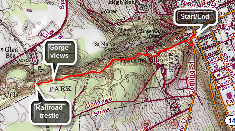
Begin your hike at the intersection of Route 329 and Route 14 or Franklin Street on the west side of Watkins Glen. There is a parking fee if you use the Watkins Glen State Park lot. The lot fills quickly especially on weekends. Public parking is available elsewhere in the village.
Walk a little less than 500 feet south on Route 329 and then turn right onto the Finger Lakes Trail as in enters the park on the South Rim Trail. The 1.3 mile trip out to the railroad trestle is all uphill but the trip back is, of course, downhill. The South Rim trail is farther away from the gorge than the other trails but still offers some nice views. At .4 miles a spur trail leaves the Finger Lakes Trail to the south to a parking area with a kiosk where the trail system is explained. At about .9 miles look to your right for some fine views of the gorge below. The views are even better when the leaves are not on the trees. You will soon see camping areas on your left. Just after the camping areas is the railroad trestle for the Norfolk Southern Railway. Walk under it and just a little farther and the turn around and walk back to where you started. You may want to walk some of the gorge trails on the way back since this is such a short hike. Not many people hike the South Rim Trail but the rails in the gorge are very popular. Choosing a weekday in the off-season give you the best chance of a little solitude in the gorge.
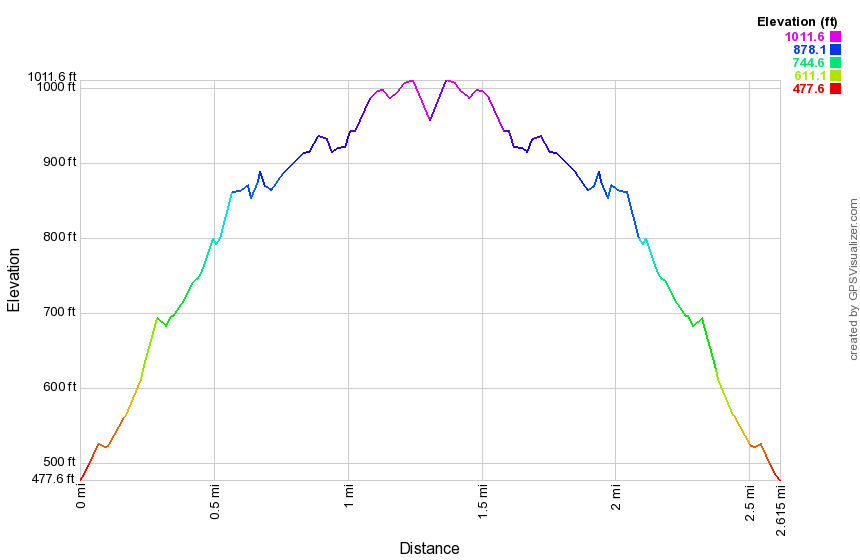 (The image at the left shows the profile of the loop hiking route. Remember that all vertical profiles are relative!)
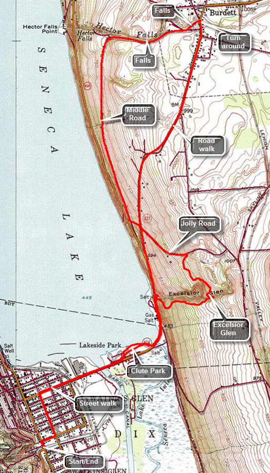
Finger Lakes Trail: Watkins Glen to Burdett
| Quick Look | ||||
|---|---|---|---|---|
| Difficulty | Round trip | Total climb | Internet Maps | |
| 9.1 mi | 1075 ft. | AllTrails | ||
 The Finger Lakes Trail is a primitive footpath that starts in Allegheny State Park on the New York - Pennsylvania border and extends 576.5 miles to end in the Catskill Park at the beginning of the Table Peekamoose Trail off the Phoenicia East Branch Trail near the Denning trailhead. There are other side trails which increase the length of the trail system. Four hundred miles of this trail is also part of the Scenic North Country Trail. The Finer Lakes Trail Conference celebrated its 50th Anniversary on June 2, 2012. To commemorate the occasion the Conference set up a series of hikes that would cover the entire length of the trail. Hikes varied in length and difficulty from 4 to 14 miles. The Trail Conference continues to improve the trails and to move sections from roads to trails.
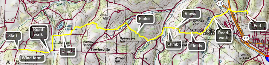
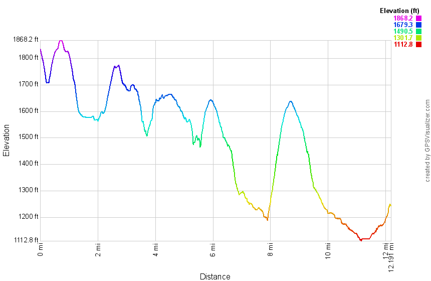
This hike can be done with a car spot since it is 9.1 miles round trip but can easily be done without one since much of the hike is on local roads. Drive north on State Route 17 to exit 52B at Horseheads. From there it is 16.5 miles north on Route 14 to the entrance to Watkins Glen State Park. Find a place to park near the park entrance but be sure to ask permission if you want to use the parking lot for a local business. From the park entrance walk one block north on Route 14 to 10th Street. Turned right and walked one block to North Decatur Street.Make a left and walk six blocks north to Route 414 and turn right. Walk the remaining .6 miles to Clute Park on the southern shore of Seneca Lake. Walk down toward the shore watching for white blazes on the trees. Follow them east as they lead back out to Route 414. Cross Seneca Lake Inlet on a road bridge and then continue to follow Route 414 as it turns north and starts to climb away from the lake. Look for the blazes that indicate a turn to the right as the trail passes through Excelsior Glen. The blazes may be absent so at about 1.75 miles watch for a stream that cuts through the rock on the right side of the road. Cross the road and to find the trail blazes and a register. The Finger Lakes Trail almost immediately turns right and starts to climb. There are also numerous other trails that appear to enter the glen following the stream. The trail begins to climb steeply and soon passes by the base of some short cliffs. The layers of rock are interesting. Continue to climb and at about 2.3 miles the trail starts to turn north and gets closer to the creek. There are several small cascades which were really nice. Soon the trail descends to the streambed above one of the falls. The descent is a little steep and can be slippery. You will have to walk across the streambed here which is why this route comes with a warning to avoid it when there are high water conditions! The trail continues heading north out of the glen and through some thick vegetation in places. At 2.8 miles the rail meets Jolly Road where the blazes indicate a turn but do not indicate the direction. Turn left and start heading northwest on Jolly Road and descend 190 feet before crossing Route 79. After crossing the road, pick up a short section of trail that descends to Middle Road. Middle Road is a dirt road that is situated between Route 414 and Route 79. It leads to Factory Street in Burdett and has very little traffic. It has some excellent views of Seneca Lake along its length. At 4.6 miles Middle Road turns east and starts to parallel Hector Falls Creek. You may hear the water in the creek below and catch some glimpses of falls and cascades. Eventually Middle Road becomes Factory Street as yo enter Burdett. At 5.2 miles turn left onto Mill Street and watch for the falls on the creek. Walk to the end of Mill Street and cross Route 79 to the firehouse and village hall. This is the turn around point of the hike. Turn right on Route 79 heading south using the sidewalks in Burdett and then the wide shoulder of the road. The walk starts out slightly uphill and then becomes flat. At 6.2 miles begin a 1.25 mile descent dropping 530 feet to the area near the lake. Follow the trail back into the park and the back out onto Route 414. Reverse your route from earlier in the day through the streets back to the car.
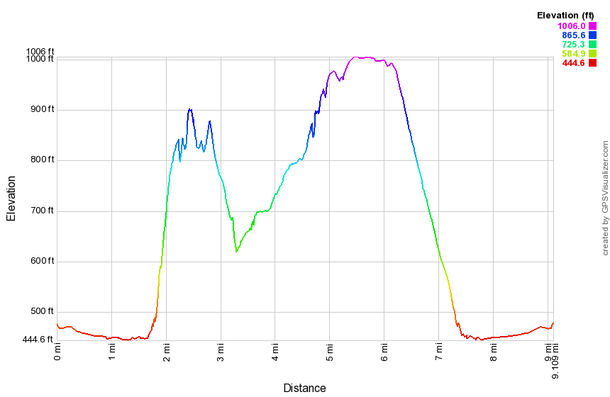 (The image at the left shows the profile of the hike. Remember that all vertical profiles are relative!)
Finger Lakes Trail: Burdett to Texas Hollow Road
| Quick Look | ||||
|---|---|---|---|---|
| Difficulty | Round trip | Total climb | Internet Maps | |
| 13.5 mi | 1960 ft. | AllTrails | ||
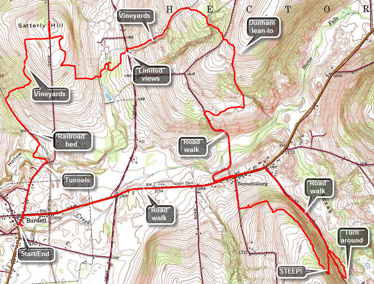 The Finger Lakes Trail is a primitive footpath that starts in Allegheny State Park on the New York - Pennsylvania border and extends 576.5 miles to end in the Catskill Park at the beginning of the Table Peekamoose Trail off the Phoenicia East Branch Trail near the Denning trailhead. There are other side trails which increase the length of the trail system. Four hundred miles of this trail is also part of the Scenic North Country Trail. The Finer Lakes Trail Conference celebrated its 50th Anniversary on June 2, 2012. To commemorate the occasion the Conference set up a series of hikes that would cover the entire length of the trail. Hikes varied in length and difficulty from 4 to 14 miles. The Trail Conference continues to improve the trails and to move sections from roads to trails.
This hike can be done with a car spot since it is 13.5 miles round trip. The "out" is 9.5 miles but the "back" is only 3.5 miles on local roads which makes the walking easier. Take State Route 17 north toward Binghamton to exit 64 at Owego. Head north from there on Route 96 through Candor and Spencer. In Spencer pick up Route 34 west to Van Etten. Turn right onto Route 224 as Route 34 heads south. Follow Route 224 for 19.2 miles as it passes through Cayuta crossing Route 13. Drive through Odessa and just outside of Montour Falls turn north on Schuyler County Route 8. Follow Route 8 for a little more than 3 miles and then turn left onto Route 9 which intersects Route 79 after 1.2 miles. Turn right and you will be in Burdett after less than a mile. Park at the fire department and village hall after asking permission or turn right at the blinking light and park at the post office. Walk to the blinking light and head north on Willow Street. At .65 miles Willow St continues on through a twin tunnel. One tunnel was for the road and the other for the stream that ran beside it. The tunnels were necessary because a railroad once ran over the road and perpendicular to it. Turn left or west on a farm lane before the tunnels which are impossible to miss. The lane is flat for a bit and then begins to climb as it turns north. At the first split in the lane stay to the right and begin to walk up toward a group of farm buildings. At about a mile another "road" goes off to the left. Turn here onto this old railroad bed and walk northwest for some time before finally spotting a faint white blaze. The railroad bed is in poor shape with large ponds in places and very muddy areas which are hard to avoid. The trail turns off the bed at 1.5 miles and heads first northeast and then due north. Upon entering the woods the trail immediately begins to gain elevation and is well-marked and obvious. Soon you will break out of the woods and hike through some abandoned vineyards. At 1.8 miles turn left and begin heading north to 2.2 miles where the trail makes a right turn to the east. Walk along some fields with views of the Catharine Valley behind and at 2.5 miles reach Slattery Hill Road. The description on the Finger Lakes Trail map mentions "views to the north and west of Seneca Lake" but there are none. Cross the road and walk through some more fields and vineyards before entering the woods. You are now well within Finger Lakes National Forest. From the road head generally south with a few jogs to the east as the trail descends to Tug Hollow Creek. At 3.7 miles crossed the creek twice and walk along it as it became deeper and wider. At 3.85 miles cross the narrow bridge and turn right. Walk uphill and cross Logan Road at 4.3 miles. On the other side of Logan Road is a "gate" and a small kiosk explaining the Finger Lakes Trail. The forest from Logan Road to Burnt Hill Road is primarily hardwood and there are some very large trees along the way. The trail ascends from the road and follows a small stream on the right heading ENE to about 5 miles where it crosses the stream and begins heading southeast. At 5.3 miles descend some and cross an impressive streambed that is often dry. After a slight ascent cross Burnt Hill Road the first time at 5.5 miles. Walk directly across the road entering the woods and continue to ascend to 5.6 miles where a long descent begins. At this point the orange blazed Interlocken Trail comes in from the north and a little farther on a side trail heads left to the Dunham lean-to. Continue on the trail heading almost due south losing elevation as you go. The trail passes through more red pines and at 6.25 miles the trail turns west to head for Burnt Hill Road again. The forest becomes more open and the trail may begin to be overgrown. At 6.6 miles turn left on Burnt Hill Road and continue to descend. The walk down the road to Route 79 is pretty easy and at 7.5 miles you will be at Route 79 after dropping over 600 feet. Turn left and walk along Route 79 for .15 miles before turning right on South Hill Road. Walk about .3 miles on the road. and at 8 miles turn left onto a farm lane. The turn is well marked and there are even some blazes on the trees that are to the left you stay on the north side of some fields while heading east. Continue to head east toward Texas Hollow Road going uphill to 8.3 miles where the trail turns south but continues to rise. The hardwood forest are pleasant as the trail continues to parallel Texas Hollow Road heading southeast but more than 300 feet above it with a steep drop off to the left. At 9.1 miles the elevation of the trail is 1550 feet and the trail begins to descend. At 9.25 miles the trail turns sharply and heads due north to Texas Hollow Road. There are several small switchbacks but the descent is very steep in places. Near the end walk down a driveway to the road. The trail crossed the road and then turns right to parallel the road for .35 miles to the access road that leads down to a pond. At the access road, turn right to walk up to Texas Hollow Road. Walk north to Route 79 for 1.25 miles with a slight uphill at the beginning and then a slight descent. Turn left on Route 79 and begin the 2.4 mile walk back to the car. The route is almost all downhill and passes by some interesting houses, a cemetery and a horse stable. At the blinking light in town, turn left and walk back to the firehouse to your car.
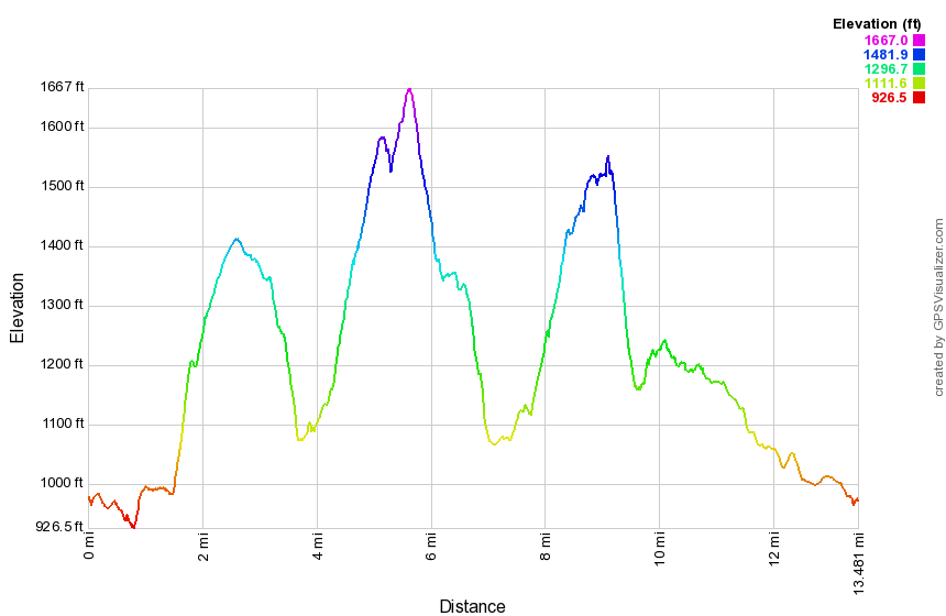 (The image at the left shows the profile of the hike. Remember that all vertical profiles are relative!)
Finger Lakes Trail: Texas Hollow Road to Gulf Road
| Quick Look | ||||
|---|---|---|---|---|
| Difficulty | Round trip | Total climb | Internet Maps | |
| 16.5 mi | 1700 ft. | AllTrails | ||
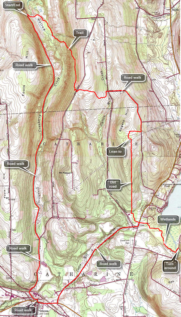 The Finger Lakes Trail is a primitive footpath that starts in Allegheny State Park on the New York - Pennsylvania border and extends 576.5 miles to end in the Catskill Park at the beginning of the Table Peekamoose Trail off the Phoenicia East Branch Trail near the Denning trailhead. There are other side trails which increase the length of the trail system. Four hundred miles of this trail is also part of the Scenic North Country Trail. The Finer Lakes Trail Conference celebrated its 50th Anniversary on June 2, 2012. To commemorate the occasion the Conference set up a series of hikes that would cover the entire length of the trail. Hikes varied in length and difficulty from 4 to 14 miles. The Trail Conference continues to improve the trails and to move sections from roads to trails.
This hike should be done with a car spot since it is 16.5 miles round trip and only 7.2 miles "out". The 7.2 miles out is on trails and dirt roads while the last 9.3 miles is on dirt and paved local roads which makes the walking easier. Another approach is to simply reverse the hike at the turn around point which would reduce the length to 14.4 miles. Take State Route 17/I86 to exit 64 at Owego and head north from there on Route 96 through Candor and Spencer. In Spencer pick up Route 34 west to Van Etten. Turn right onto Route 224 as Route 34 heads south. Followed Route 224 for 16.4 miles as it passes through Cayuta crossing Route 13. In Odessa turn right on Mill St and then left onto Brooklyn Terrace. At the top of the hill continue straight ahead on Texas Hollow Road and stay to the left when the road splits. Drive 5.4 miles to a gated access road that has a "Finger Lakes Trail" on the right. Park on the right shoulder of the road before the access road. Begin your hike walking down the gated access road to pick up the white blazes of the Finger Lakes Trail at the base of the road. There is a nice pond here and a wooden walkway that crosses over some very wet ground. Be careful as you cross the walkway as hikers have reported some aggressive bees in the area! Continue around the pond heading southeast and then south. Since you are in a "hollow", there will be some climbing to get out. None of the ascents are long or steep but over the first 1.4 miles the trail gains over 650 feet. The trail is easy to follow by the way it was worn in and by the blazing. The blazing is odd in places with the non-standard blaze over blaze to indicate a turn without the direction of the turn being clear. There are some turns indicated where there are none and several other turns left unmarked. At 2.1 miles cross Newton Road which is dirt and gravel. The trail starts heading east and ascends slightly before dropping to Steam Mill Road at 2.9 miles. When the trail leaves the woods on Steam mill Road, continue straight ahead on dirt and gravel Carly Road. Continued on the road as it turned right at the top of a small hill. At about 3.6 miles there is a nice view of the surrounding hills and valleys. Continue on the road as it descends a little and then passes Hosenfeldt Road on the left. At the top of the next hill turn right on Seneca Highlands which is a private road. There are signs that indicate that the area is used for motocross events and other motorsports. The road leads to a private picnic area and pond with the Rogers Hill lean-to at 4.4 miles. Continue to follow the blazes as they lead back out onto a dirt road that heads due south. This section of trail continues for about 1.7 miles turning slightly southeast near the end. The drop in elevation is gentle but at the intersection with Route 228 at 6.1 miles the elevation loss is almost 500 feet. Continue straight ahead on South Pine Road passing the Schuyler County Veterans Park on the right. It is a small park but nicely designed to honor the county's veterans. Continue down the road until at 6.2 miles where the trail turns right. For the next .9 miles head southeast along the wetlands adjacent to Cayuta Creek. The trail can be wet in spots. At Route 6, turn left and walk to Gulf Road where you will turn around at 7.2 miles. Reverse your route and Walk to Route 228. Turn left on Route 228 and follow it as it turns right at the next intersection to head toward Route 224 and Odessa. Over the next 2.25 miles hike downhill losing about 320 feet along the way. The shoulders are wide and the traffic generally light. At Route 224 turn right and hike .4 miles into Odessa turning right on Mill St and then left on Brooklyn Terrace. At the top of the hill continue straight ahead on Texas Hollow Road for 5.4 miles. The very first part of the road is a rather steep uphill followed by a short descent. After that the road climbs slightly until 15.6 miles with the last mile being a slight descent. At 12.2 miles Newton Road branches to the right and Texas Hollow road changes to dirt and gravel. Be sure to stay left on Texas Hollow Road.
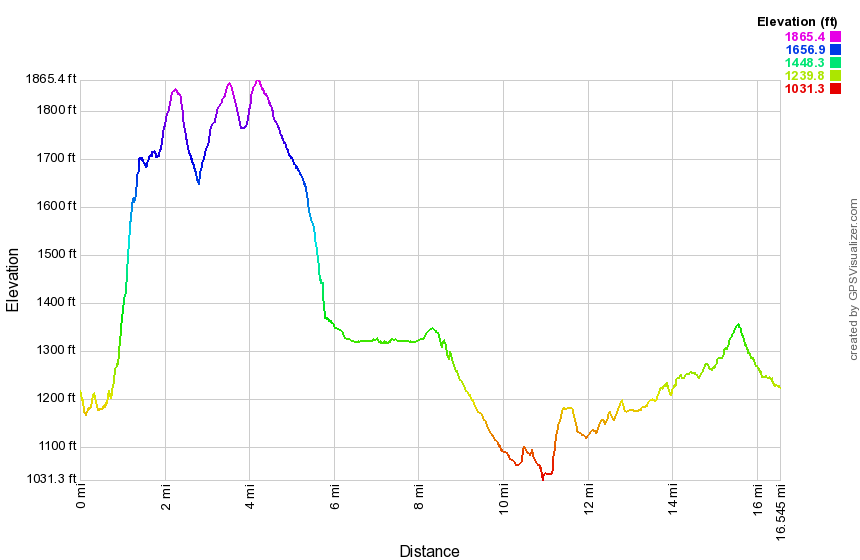 (The image at the left shows the profile of the hike. Remember that all vertical profiles are relative!)
Finger Lakes Trail: Gulf Road to Boylan Road
| Quick Look | ||||
|---|---|---|---|---|
| Difficulty | Round trip | Total climb | Internet Maps | |
| 10.5 mi | 1420 ft. | AllTrails | ||
 The Finger Lakes Trail is a primitive footpath that starts in Allegheny State Park on the New York - Pennsylvania border and extends 576.5 miles to end in the Catskill Park at the beginning of the Table Peekamoose Trail off the Phoenicia East Branch Trail near the Denning trailhead. There are other side trails which increase the length of the trail system. Four hundred miles of this trail is also part of the Scenic North Country Trail. The Finer Lakes Trail Conference celebrated its 50th Anniversary on June 2, 2012. To commemorate the occasion the Conference set up a series of hikes that would cover the entire length of the trail. Hikes varied in length and difficulty from 4 to 14 miles. The Trail Conference continues to improve the trails and to move sections from roads to trails.
This hike can be done with a car spot but is only 10.5 miles round trip. The first 8.8 miles is on trails and dirt roads while the last 1.7 miles is on paved local roads which makes the walking easier. Flooding early in the summer of 2015 washed out the bridges over Cayuta Creek on the main Finger Lakes Trail. It may be possible to cross the creek in drier weather but this route follows the Van Lone Hill alternate route. Take State Route 17/I86 to exit 64 at Owego and head north from there on Route 96 through Candor and Spencer. I continued on Route 17 to exit 64 at Owego and headed north from there on Route 96 through Candor and Spencer. In Spencer take Route 34 west to Van Etten. Turn right in Van Etten onto Route 224 when Route 34 heads south. Follow Route 224 for 14.7 miles as it passes through Cayuta crossing Route 13. Just short of 15 miles on Route 224, turn right to head north on Route 10 for 1.6 miles to Route 6. Turn right on Route 6 and drive about a mile to Gulf Road. Park on the shoulder of Route 6 just before Gulf Road. Start your hike by walking down Gulf Road. After a short distance on Gulf Road, the Finger Lakes Trail turns to the right to enter Cayuta Gulf. Stay to the left on Gulf Road and begin to climb Van Lone Hill on the dirt road. The road is well-maintained and has several houses. Eventually the road comes to a dead end. Continue to follow the orange blazes as they enter the woods. It is clear that the road once continued over the hill. At .75 miles reach the highest point on the trail at 1700 feet and immediately begin to descend the other side. The trail follows a deep creek bed that typically has only a trickle of water. The creek eventually crosses and then recrosses the road. From the amount of stones that are piled up it is obvious that this small creek has at times been filled to overflowing with a huge volume of water. At 1.6 miles reach Schoolhouse Road heading due east. Although the road is dirt and gravel it is in good shape. After .6 miles, turn right on Todd Road where Schoolhouse Road ends and start a slight descent. Cross a tributary of Cayuta Creek on a road bridge. Todd Road begins to ascend to the point where the main Finger Lakes Trail crosses the road. This crossing is clearly marked and at 2.6 mile turn left onto the trail as it passes through the woods on an old road. After entering the woods, the trail crosses several open areas with high grass and weeds which may not be trimmed back.The trail heads north and east and climbs some the whole way. At 3.25 miles the trail follows a well-established woods road heading due east. The blazes are few and far between but the road is very easy to follow. At about 3.8 miles watch for a turn to the left off the road. The blazes may be hard to see! The trail parallels the road heading east but may be drier and better maintained. At 4.1 miles cross another dirt road as the trail starts heading north. Many of the dirt roads in the Connecticut Hill Wildlife Management Area are called Connecticut Hill Road! Continue north on the trail and cross Cabin Road at 4.4 miles. The trail rolls some but continues to gain elevation as it heads north toward Boylan Road. At 5.9 miles hit the highest point on the hike at 2014 feet and then start to descend toward the road. The trail crosses an open area where there is no indication of where to go. You may find a narrow green strip across the open area which leads to the road. Turn right on Boylan Road and walk east to where the trail reenters the woods. From here turn around and head west on Boylan Road and turn left where it intersects the next dirt road. After a few hundred feet turn right on another dirt road. This road continues west to Route 6 which is a paved road. However, the road ends after a short distance and becomes a woods road until it again turns into a dirt road near Route 6. The route is pretty easy to follow as long as you continue to head west. The road has a gate that is sometimes shut and locked. Walk along the road for about .6 miles where, at 7.25 miles, the dirt road ends. From that point on follow the woods road west as it passes through woods and then open fields. The track is pretty easy to follow but was badly rutted in many places. Soon the road becomes more consolidated. Come to a stream where there was once a bridge. Cross the stream on the rocks. At about 8 miles the road becomes a "maintained" dirt road again which is marked as Van Loon Road on both maps and GPS. At 8.8 miles turn left on Route 6 and start south toward the car. The road passes by the eastern shore of Cayuta Lake. There are no views of the lake as the road is farther from the lake than it appears on the map and there are trees blocking the view. The walk south on Route 6 back to the car is only 1.7 miles.
 (The image at the left shows the profile of the hike. Remember that all vertical profiles are relative!)
Finger Lakes Trail: Boylan Road to Stevenson Forest Preserve
| Quick Look | ||||
|---|---|---|---|---|
| Difficulty | Round trip | Total climb | Internet Maps | |
| 9.9 mi | 1480 ft. | AllTrails | ||
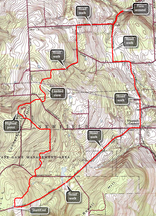 The Finger Lakes Trail is a primitive footpath that starts in Allegheny State Park on the New York - Pennsylvania border and extends 576.5 miles to end in the Catskill Park at the beginning of the Table Peekamoose Trail off the Phoenicia East Branch Trail near the Denning trailhead. There are other side trails which increase the length of the trail system. Four hundred miles of this trail is also part of the Scenic North Country Trail. The Finer Lakes Trail Conference celebrated its 50th Anniversary on June 2, 2012. To commemorate the occasion the Conference set up a series of hikes that would cover the entire length of the trail. Hikes varied in length and difficulty from 4 to 14 miles. The Trail Conference continues to improve the trails and to move sections from roads to trails.
This hike can be done with a car spot but is only 9.9 miles round trip. The first 3.5 miles is on trails while the last 6.4 miles is on local roads which makes the walking easier. Take State Route 17/I86 to exit 64 at Owego and head north from there on Route 96 through Candor and Spencer. Route 96 eventually picks up the designation as Route 34. North of Spencer turn left on Newfield Depot Road and follow it into Newfield. Watch for Trumbulls Corners Road and continue to head west. Trumbulls Corners Road changes to Blovsky Hill Road but that change which occurs at a four-way intersection may not obvious. Blovsky Hill Road ends at an intersection where you should bear right on Carter Creek Road. Somewhere along this route the paved road turns to gravel. After less than a mile watch for Lloyd Starkes Road on the right and enters the Connecticut Hill Wildlife Management Area. This road is marked "Seasonal Maintenance" and is passable but very rough. At the end make a hard left onto Boylan Road. This road is dirt and gravel but in pretty good shape until the intersection with Hulford Road where there is another "Seasonal Maintenance" sign. Fortunately, the Finger Lakes Trail crosses the road just beyond the intersection. Park on the right side where there is room for two cars or on the wide shoulder on the left. Begin your hike by crossing the road and walking southwest on the road to enter the woods on the right. The trail is very well marked and seems well used. Start by heading northeast and descending to Connecticut Hill Road which is reached at .7 miles. Cross the road and turn right to walk east a bit and then turn left or north into the woods again. At 1.3 miles the trail heads due north along a property line and then turns due west at 1.7 miles continuing to follow a private property line on state land. Continue uphill and northwest to cross Tower Road at 2 miles. At 2.2 miles pass over the summit of Connecticut Hill which at 2100 feet is the highest1 spot on the Finger Lakes Trail for 40 miles around. From the top of the hill head northeast and continue to descend crossing Cayutaville Road at 2.75 miles. Turn right on the road and walked southeast briefly before reentering the woods and heading north toward Griffin Road. The trail turns right on Griffin Road at 3.45 miles and from here to Stevenson Forest Preserve the trail follows local roads. Follow Griffin Road east and then north to where it intersects Connecticut Hill Road at 4.1 miles. Continue north on Connecticut Hill Road to 4.6 miles where Rumsey Hill Road turns right. Turn right and follow Rumsey Hill Road east dropping 300 feet in .6 miles. At the intersection with Trumbulls Corners Road turn left and walk .35 miles to the parking area for Stevenson Forest Preserve. You are now at the lowest elevation on the hike at 1250 feet and the rest of the hike would be mostly uphill. Turn around and walked back up Trumbulls Corners Road heading south and gaining some elevation. At 6.2 miles follow the road as it makes a left turn and follow it again at 6.5 miles when it makes a right turn heading south. At 7.5 miles turn right on Cayutaville Road and follow that only .1 miles uphill before bearing left on another version of Connecticut Hill Road. At 8.8 miles pass by the intersection with Lloyd Stakes Road and bear left on Boylan Road. These roads are mostly gravel and dirt but Boylan Road is a little rougher. The walk along Boylan Road is about a mile and this is where you gain the final 300 or so feet to the elevation of you car. Continue uphill passing Hulford Road on the left and finally arriving at your car.
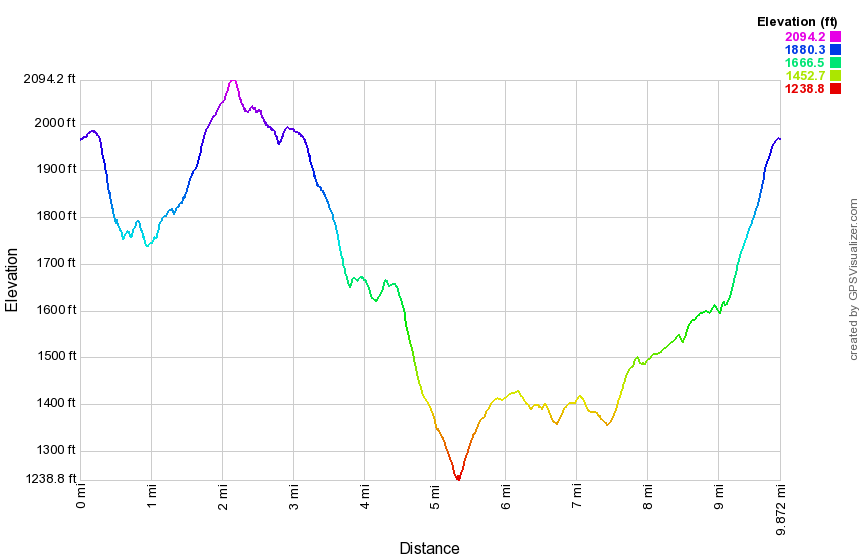 (The image at the left shows the profile of the hike. Remember that all vertical profiles are relative!)
Finger Lakes Trail: Route 13 to Stevenson Forest Preserve
| Quick Look | ||||
|---|---|---|---|---|
| Difficulty | Round trip | Total climb | Internet Maps | |
| 15.5 mi | 2133 ft. | AllTrails | ||
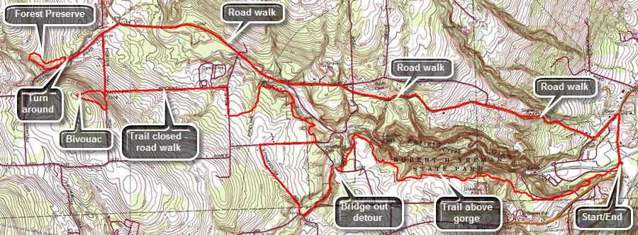 The Finger Lakes Trail is a primitive footpath that starts in Allegheny State Park on the New York - Pennsylvania border and extends 576.5 miles to end in the Catskill Park at the beginning of the Table Peekamoose Trail off the Phoenicia East Branch Trail near the Denning trailhead. There are other side trails which increase the length of the trail system. Four hundred miles of this trail is also part of the Scenic North Country Trail. The Finer Lakes Trail Conference celebrated its 50th Anniversary on June 2, 2012. To commemorate the occasion the Conference set up a series of hikes that would cover the entire length of the trail. Hikes varied in length and difficulty from 4 to 14 miles. The Trail Conference continues to improve the trails and to move sections from roads to trails.
This hike is best done with a car spot since it is 15.5 miles round trip. This is divided into the "out" which is 10 miles of trail and road walking and the "back" which is 5.5 miles of road walking. The return trip is on local roads which makes the walking easier. Take State Route 17/I86 to exit 64 at Owego and head north from there on Route 96 through Candor and Spencer. Route 96 eventually picks up the designation as Route 34 and they both merge with Route 13. At the point where they begin to merge there is a parking area on the east side of the road. If you cross the bridge over Enfield Creek, you have gone too far. Start your hike by walking under the road bridge along Enfield Creek and following the white blazes through a flat and damp area. Cross a park road and continue through some damp areas. Begin to climb to the rim of the gorge cut by Enfield Creek. Enfield Creek is the lowest point on the Finger Lakes Trail so some climbing will always be involved when starting there! At about a mile come to the Sierra Shelter and watch for the left turn right before it. The next section of trail may be overgrown with briars and weeds. At around 2 miles most of your climbing is done and you will have gained about 630 feet since leaving the car. you may hear the water in Enfield Creek as it flows over various cascades and waterfalls. Walked west for some time through stands of red pine and some hardwood. The trail rolls some especially when crossing small tributaries of the main creek. At 2.25 miles begin to head northwest sticking to a route that parallels the creek but well above it. At 2.9 miles start to head southwest joining a park road briefly and then entering the forest again. When you come to a Y in the trail, the main Finger Lakes Trail continues straight ahead toward the bridge of the Fish Kill. The bridge has been washed away so stay to the left and walk out to Butternut Creek Road. Turn right on this gravel road and walked first downhill and then uphill to 3.7 miles where the road joins Van Ostrand Road. After a short distance, turn right on Douglas Road and then stay to the right on Stonehouse Road. This road heads north and uphill for about .7 miles to Woodard Road at 4.5 miles. Turn right and walk less than half a mile to where the Finger Lakes Trail crosses the road. The sign on the right side of the road announces the bridge is out and indicates it is only 3.5 miles back to the car. You have already walked 5 miles so the detour adds about 1.5 miles to the hike. Turn left into the woods and head north and northwest generally following Enfield Creek. Parts of this section of trail may not be well trimmed. The trail travels close to the creek and you can hear the traffic on Route 327 on the other side. At 5.9 miles the trail turns left and starts heading southwest toward Hines Road. Intersect Hines Road at 6.35 miles and turn right to walk due north for a quarter mile to Rockwell Road. Turn left on Rockwell Road and begin to walk due west toward Potter Hill Road. After about .75 miles watch for a trail on the left which connects to the main Finger Lakes Trail and runs parallel to Potter Hill Road. Part of the trail in this area has been closed by a landowner. If you miss the trail, continue another .25 miles to Potter Hill Road. Turn left on Potter Hill Road and hike uphill for .15 miles to where the trail crosses the road. Turn right into the woods and walk uphill to 7.75 miles where the trail makes a sharp right to head back of to the road. The quarter mile hike back out to Potter Hill Road is all downhill. Turn left on Potter Hill Road and begin to walk .5 miles north to Trumbulls Corners Road. Turn left on Trumbulls Corners Road and walk slightly uphill until you see the white blazes enter the woods just after crossing a creek on a road bridge. Turn right into the woods and watch for the blazes which go off to the left a little and then start to climb a steep pitch. The entire loop is less than a mile and has no views except for the large hemlock trees. The trail rejoins Trumbulls Corners Road at the parking area for Stevenson Forest Preserve. Turned left and walk 2. miles back to where you entered the woods. Continue on Trumbulls Corners Road passing the turn on Potter Hill Road and walking out to Route 327. Turn right on Route 327 and start the 5.5 mile return trip to the car. There are several short climbs along the way but the route is mostly downhill as you drop from about 1100 feet to 425 feet. At 13.4 miles there are no more climbs as you head downhill to Route 13. Pass the entrance to Robert Treman Park and then walk out to Route 13. Be careful crossing this busy road! Turn right and walk on the shoulder of the road back to the parking area.
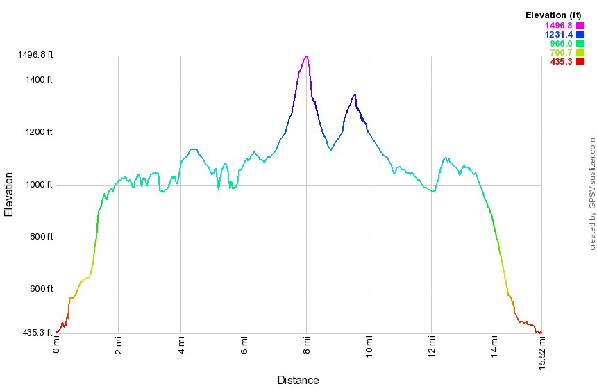 (The image at the left shows the profile of the hike. Remember that all vertical profiles are relative!)
Finger Lakes Trail: Comfort Road to Route 13
| Quick Look | ||||
|---|---|---|---|---|
| Difficulty | Round trip | Total climb | Internet Maps | |
| 13.9 mi | 1983 ft. | AllTrails | ||
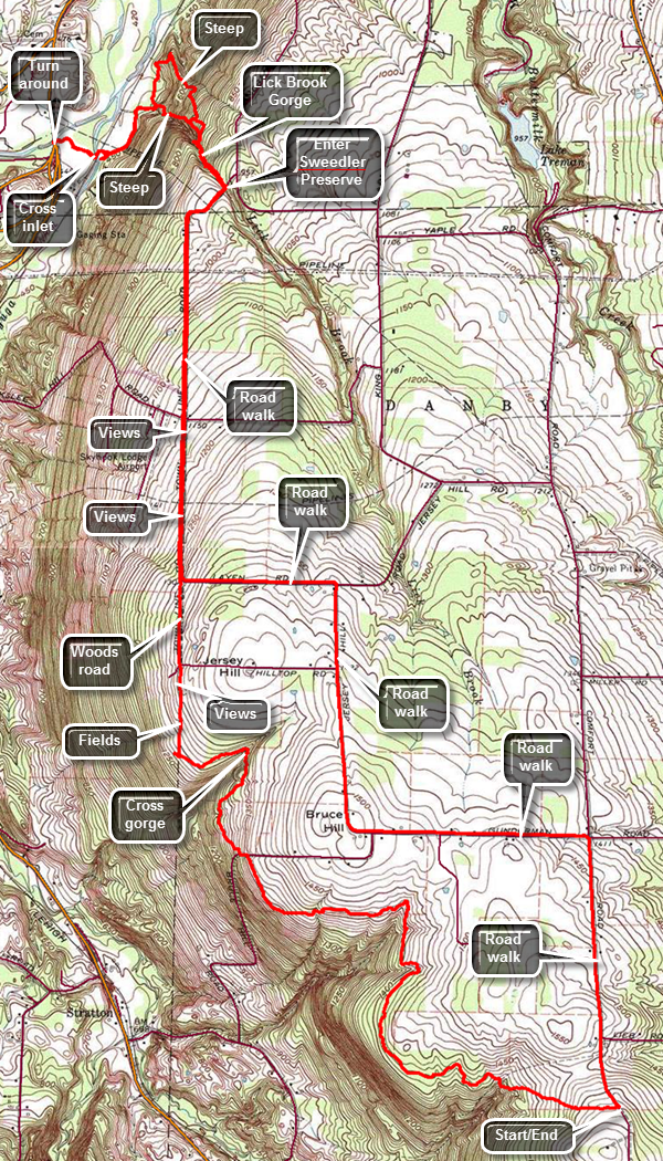 The Finger Lakes Trail is a primitive footpath that starts in Allegheny State Park on the New York - Pennsylvania border and extends 576.5 miles to end in the Catskill Park at the beginning of the Table Peekamoose Trail off the Phoenicia East Branch Trail near the Denning trailhead. There are other side trails which increase the length of the trail system. Four hundred miles of this trail is also part of the Scenic North Country Trail. The Finer Lakes Trail Conference celebrated its 50th Anniversary on June 2, 2012. To commemorate the occasion the Conference set up a series of hikes that would cover the entire length of the trail. Hikes varied in length and difficulty from 4 to 14 miles. The Trail Conference continues to improve the trails and to move sections from roads to trails.
This hike is best done with a car spot since it is 13.9 miles round trip and has some steeps spots especially in Lick Brook Gorge. The return trip is on local roads which makes the walking easier. Take State Route 17/I86 to exit 64 at Owego and head north from there on Route 96 and Route 96B. After passing the "Welcome to Danby" sign watch for Bald Hill Road on the left. Turn left and continue for about .7 miles before making a right on Lieb Road. At the end of Lieb Road turn left on dirt and gravel Comfort Road. After only .2 miles the Finger Lakes Trail joins the road from the west. Turn around and park in a wide spot on the east side of the road. Start your hike by walking across the road to pick up the trail as it heads west from Comfort Road. The trail may initially wet and descends to an abandoned road. After this, the trail follows a contour line without gaining or losing much elevation until it turns north at 2.4 miles. You will drop a little to Bruce Hill Road at 2.7 miles where the trail and turns left to briefly follow the road until turning into the woods. Shortly after entering the woods there is a double tree trunk and a large tree beyond it. After this make a slight swing to the east to avoid a deep gully formed by a tributary to the Cayuga Inlet. Come out of the woods into a field where the next blazes are not obvious. Walking across the upper part of the field and through an opening to the next field. Walk along the hedge row and pick up the white blazes on the far side. When you come to the next set of fields, you will have the same problem except there is a blaze on a tree near the middle of the field. After that blaze, there are no others you can easily spot. At the far side of the field turn right and walk along the west side of the field next to the hedgerow heading north. If you look carefully, you may see one or two old, faded white blazes. Watch for views to your left or west as the hedgerow thins. When you come to the edge of the field, cross a road or driveway and to a woods road. This is the end of Town Line Road which is grass at this point. At 4.25 miles Then line Road intersects Layen Road. Both Town Line Road and Layen Road are gravel covered at this point. Continue walking down Town Line Road losing elevation as you go. The road was absolutely straight as you cross West Jersey Hill Road on your 1.5 miles trek. Arrive at the point where the road curves to the right and continue to follow it as it crosses a bridge over Lick Brook. This is the Sweedler Nature Preserve owned by the Finger Lakes Land Trust. From the bridge you can see a deep gorge cut by this little brook. This is a popular destination with several different trails. Just after the bridge turn left at 5.9 miles to follow the Finger Lakes Trail down through the gorge. There are several small falls and many interesting rock formations along the gorge. At 6.2 miles pass by the upper falls without a good view. Just after this the Finger Lakes Trail heads away from the gorge to take a slightly less steep route. The blue Lick Gorge Trail stays to the left along the gorge. Turn right to follow the Finger Lakes Trail. You will return on the blue trail. At 6.3 miles a short spur trail on the left connects the two trails. Turn a little to the right here to follow the Finger Lakes Trail across a stream and to continue your descent along a spit of land that is between Lick Brook on the left and another stream on the right. At 6.7 miles make almost a 180 degree turn to the left and head down to Lick Brook again. The trail passes the bottom of the lower falls and which is largely hidden from the trail. Continue along the trail to the edge of Cayuga Inlet which can be deep and wide depending on the recent rainfall patterns. If you feel you can cross the stream without problems, you should have water shoes and a bag to keep your pack dry just in case. The railroad bridge that crosses the stream is a private bridge. Although there are no signs, crossing it is trespassing. This is the lowest point on the Finger Lakes Trail at about 425 feet! Since turning off the road and into the gorge area you have lost 650 feet and are over 1100 feet lower than where the car is parked. On the other side of the stream hike out to a field and continue to follow the blazes to a large parking area on the east side of Route 13. The blazes continue under a bridge across Enfield Creek. Follow the blazes to the other side then turn around and head back. Turn right after the lower falls on the blue trail. The distance to where the blue trail meets the Finger Lakes Trail is only .25 miles but in that distance the trail gains 350 feet for an average 24% slope. On the way up you may walk to the edge of the cliff and get a view of the lower falls. Farther up the trail where it starts to level out, there is a glimpse of the upper falls through the trees. Continue up to the road and turn right to start the road walk back on Town Line Road. At Layen Road turn left to walk the roads back to the car instead of taking the trail. Walk uphill on Layen Road for .6 miles and turn right onto Jersey Hill Road. The roads are very straight which makes the distances seem longer. Pass Hilltop Road on the right. After 1 mile look for left turn onto Gunderman Road. Once you turn onto Gunderman Road and watch for Comfort Road on the right. After .9 miles turn right on Comfort Road and watch for the junction with Lieb Road after about .8 miles. Your car is only .2 miles away but up a small hill.
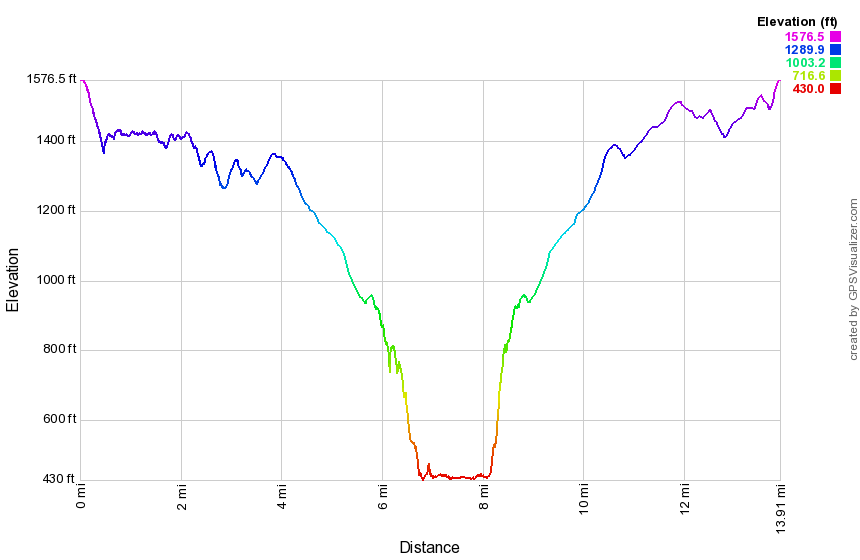 (The image at the left shows the profile of the hike. Remember that all vertical profiles are relative!)
Finger Lakes Trail: Comfort Road to Fisher Settlement Road
| Quick Look | ||||
|---|---|---|---|---|
| Difficulty | Round trip | Total climb | Internet Maps | |
| 12.3 mi | 1780 ft. | AllTrails | ||
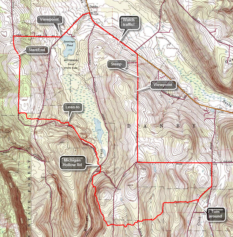 The Finger Lakes Trail is a primitive footpath that starts in Allegheny State Park on the New York - Pennsylvania border and extends 576.5 miles to end in the Catskill Park at the beginning of the Table Peekamoose Trail off the Phoenicia East Branch Trail near the Denning trailhead. There are other side trails which increase the length of the trail system. Four hundred miles of this trail is also part of the Scenic North Country Trail. The Finer Lakes Trail Conference celebrated its 50th Anniversary on June 2, 2012. To commemorate the occasion the Conference set up a series of hikes that would cover the entire length of the trail. Hikes varied in length and difficulty from 4 to 14 miles. The Trail Conference continues to improve the trails and to move sections from roads to trails.
This hike can be done with a car spot since it is 12.3 miles round trip. The return trip is on local roads which makes the walking easier. Take State Route 17/I86 to exit 64 at Owego and head north from there on Route 96 and Route 96B. After passing the "Welcome to Danby" sign watch for Bald Hill Road on the left. Turn left and continue for about .7 miles before making a right on Lieb Road. At the end of Lieb Road turn left on dirt and gravel Comfort Road. After only .2 miles the Finger Lakes Trail joins the road from the west. Turn around and park in a wide spot on the east side of the road. Start your hike by walking south on Comfort Road for a mile. After a mile, turn left into the woods at a clearly marked turn. Cross Bald Hill Road at 1.4 miles and immediately re-enter the woods on the other side. The trail passes through both hardwood and pine forests. There were several stands of red pine that were obviously planted at some time. At 1.9 miles the Chestnut lean-to will be on the left. Just after the lean-to the trail turns sharply right and comes to a logging road. Continue directly across the logging road and descend to a left turn onto a woods road as you approach Michigan Hollow Road. Cross Michigan Hollow Road and continue heading south crossing washed-out Smiley Road and a small stream. The trail begins to climb from 1290 feet at the road to 1630 feet at 4.1 miles where the trail turns east. On the way there are a few ups and downs. Cross Hill Road at 4.2 miles and descend to a small stream. After a short ascent, cross Curtis Road at 4.7 miles and again descend to a stream. This stream is wider than some in the area and has a bridge. The stream has been rerouted since the near end of the bridge is in the water. After crossing, turn right to pick up the blazes. Just after the stream, the trail turns northeast and then, at 5.3 miles, heads due east. Pass through some red pines while ascending and then began to descend to Fisher Settlement Road. The trail here may be wet and muddy and is bordered by briars and wild roses. The trail meets the road at 5.9 miles. Turn right to walk to the beginning of the next section of trail. Start your return trip by walking north to South Danby Road and heading north to Hill Road which roughly parallels Route 96B. At 6.7 miles turn left on Hill Road and get ready to ascend. The walk to the next intersection is 1.2 miles and is pretty evenly divided between uphill and then downhill. At the intersection with Curtis Road turn right on Curtis Road and walk out to Route 96B. This road also rolls some with an initial descent and then a short climb. The road starts to drop sharply at about 8.6 miles and there is a nice view of the valley below. At Route 96B turn left and walk a little over a mile to Bald Hill Road. Turn left and start to walk toward Lieb Road. Before making the right turn on Lieb Road, take a minute to view Jennings Pond on the left which is part of Buttermilk Falls State Park. Continue your walk back to the car by turning left onto Lieb Road and making a left at the end onto Comfort Road.
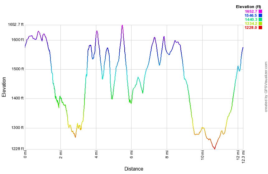 (The image at the left shows the profile of the hike. Remember that all vertical profiles are relative!)
Finger Lakes Trail: Fisher Settlement Road to Heisey Road
| Quick Look | ||||
|---|---|---|---|---|
| Difficulty | Round trip | Total climb | Internet Maps | |
| 8.0 mi | 1334 ft. | AllTrails | ||
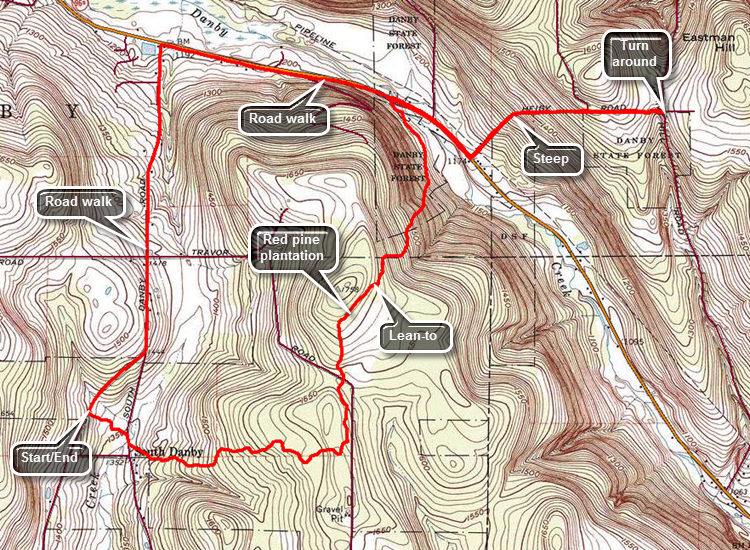 The Finger Lakes Trail is a primitive footpath that starts in Allegheny State Park on the New York - Pennsylvania border and extends 576.5 miles to end in the Catskill Park at the beginning of the Table Peekamoose Trail off the Phoenicia East Branch Trail near the Denning trailhead. There are other side trails which increase the length of the trail system. Four hundred miles of this trail is also part of the Scenic North Country Trail. The Finer Lakes Trail Conference celebrated its 50th Anniversary on June 2, 2012. To commemorate the occasion the Conference set up a series of hikes that would cover the entire length of the trail. Hikes varied in length and difficulty from 4 to 14 miles. The Trail Conference continues to improve the trails and to move sections from roads to trails.
This hike can be done with a car spot but it is only 8 miles round trip. The return trip is on local rods which makes the walking easier. Take State Route 17/I86 to exit 64 at Owego and head north from there on Route 96 and Route 96B. After passing through Candor watch for South Danby Road on the left. Turn left and drive about 1.3 miles to Fisher Settlement Road. Turn right and drive another .3 miles to where the trail enters the woods on the left. Turn around and parked off the road on the grassy shoulder. Start your hike by walking into the woods on the trail heading generally east toward South Danby Road. Descend for .25 miles to South Danby Road and after crossing it began an ascent of about 300 feet over the next mile. At 1.3 miles the trail turns almost 90 degrees left and heads north toward Route 96B. Descend slightly and then climb to the highest point on the hike at 1760 feet at the 2 mile mark. Just after this the trail turns slightly to the left and a spur trail goes to the Tamarack lean-to. Several parts of the trail travel through impressive stands of red pine that were obviously planted at one time. They are very tall and very regularly spaced. Over the next mile to Route 96B you will lose 560 feet heading north. There are some steep places and a few may be slippery with mud. Cross the road and pick up the trail as it turns right to parallel the road for .2 miles. The short section of trail ends at Durfee Hill Road and a sign post marks a turn to the right back out to Route 96B. A section of trail at the top of Durfee Hill Road has been closed by the landowner and the trail has been rerouted. At Route 96B turn left and walk along the shoulder for .2 miles to Heisey Road. Turn left and get ready for a climb since over the next .5 miles the elevation gain is about 435 feet to the highest point on Heisey Road. Hike down from the high point to the intersection with Eastman Hill Road. There is room to park one or two cars but the last part of Heisey Road is very washed out and would require some careful maneuvering in a vehicle. Turned around at 5.8 miles and walk back down Heisey Road to Route 96B. Turn right on Route 96B and walk 1.4 miles to South Danby Road. Turn left and walk uphill for 1.25 miles to Fisher Settlement Road. Turn right and walk the final .3 miles back to the car.
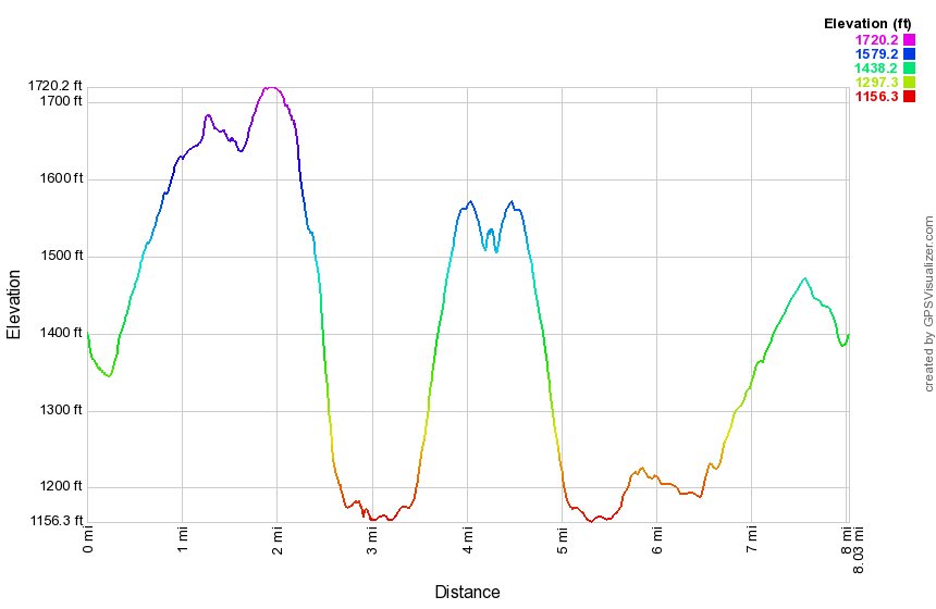 (The image at the left shows the profile of the hike. Remember that all vertical profiles are relative!)
Finger Lakes Trail: Heisey Road to Braley Hill Road
| Quick Look | ||||
|---|---|---|---|---|
| Difficulty | Round trip | Total climb | Internet Maps | |
| 9.7 mi | 1878 ft. | AllTrails | ||
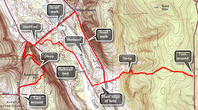 The Finger Lakes Trail is a primitive footpath that starts in Allegheny State Park on the New York - Pennsylvania border and extends 576.5 miles to end in the Catskill Park at the beginning of the Table Peekamoose Trail off the Phoenicia East Branch Trail near the Denning trailhead. There are other side trails which increase the length of the trail system. Four hundred miles of this trail is also part of the Scenic North Country Trail. The Finer Lakes Trail Conference celebrated its 50th Anniversary on June 2, 2012. To commemorate the occasion the Conference set up a series of hikes that would cover the entire length of the trail. Hikes varied in length and difficulty from 4 to 14 miles. The Trail Conference continues to improve the trails and to move sections from roads to trails.
This hike is probably best done by parking on Ridgeway Road and hiking to Heisey Road and then back. After that, hike to Braley Hill Road and then back from there. Blackman Hill Road and Heisey Road are both in poor condition which makes parking at the true beginning of map 18 very difficult. Take State Route 17/I86 to exit 64 at Owego and head north from there on Route 96 and Route 96B. After passing through Candor begin to look for Willseyville Road on the right. Turn right on this road and then right again onto Coddington Road. Drive north 4 miles, turn right on Ridgeway Road and park on the wide shoulder. Start your hike by walking back out to Route 96B and turning right to head north for about .15 miles. Turn left on a woods road after only about .15 miles. After only a short distance, another woods road goes off to the right but you should stay left and climb the hill. The trail begins a steady climb at about a 15% grade over the next .25 miles. At .42 miles there is a sharp turn to the left onto another woods road and the turn may be poorly marked. After a short distance on this road, the trail makes an abrupt turn to the right. The trail follows various woods roads of which there are many so watch the blazes carefully. A viewpoint over the Willseyville Valley is marked on the map but there is no viewpoint there anymore. At 1.1 miles you will be at the highest point on Eastman Hill having gained over 600 feet since leaving the car. So far the trail should be mostly dry but you may begin to encounter wet and muddy areas of the trail as you approach Eastman Hill Road. At 1.45 miles turn left on Eastman Hill Road which is little more than a path and walk to the intersection with Heisey Road. Turn around and walked the 1.5 miles back to the car. Continue the hike by walking northeast on Ridgeway Road for only a few hundred feet before turning right into a clearing which looks like a small park. Turn left into the woods after only a few hundred feet. The trail follows a woods road but eventually leaves the road and winds through the woods making a sharp right at about 3.5 miles. You are now descending slightly and heading southeast. At 3.85 miles turn right on a flat railroad bed which was once part of the Lebanon Valley Railroad. Begin to walk along the level bed between two wetlands. Take advantage of any opening on the left to get a good view of the extensive wetlands. At 4.4 miles the blazes indicate a sharp left turn into the woods and lead you to a field where the blazes all but disappear. Turn left and walk east to White Church Road along the north side of the field. Cross the road and walk along the north edge of another field without the aid of blazes. At 4.8 miles the trail curls around the back edge of the field to the right and blazes indicate a left turn. Follow the trail as it crosses a stream on a wooden bridge. Continue on to a grassy clearing with white blazes on stakes. The trail enters the woods and is sited on a woods road which it follows as it climbs the hill heading almost due east. Several roads cut across the trail and the blazing could be better in some places. At 5.75 miles the trail reaches 1680 feet which is a climb of about 700 feet from White Church Road. As you continue to Braley Hill Road, the trail drops about 150 feet over .4 miles. At this point you are at about 6.2 miles. Turn around and follow the trail back over the hill to White Church Road. Turn right and head north toward Ridgeway Road. The road gains a little elevation but the alternate path along open road is a welcome change. After walking about 1.2 miles on the road, turn left on Ridgeway Road at about 8.9 miles. Looking ahead the road descends to a low spot and then ascends again to the car. The low point is the old railroad bed. and the ascent to the car is actually less difficult than it looks from the intersection.
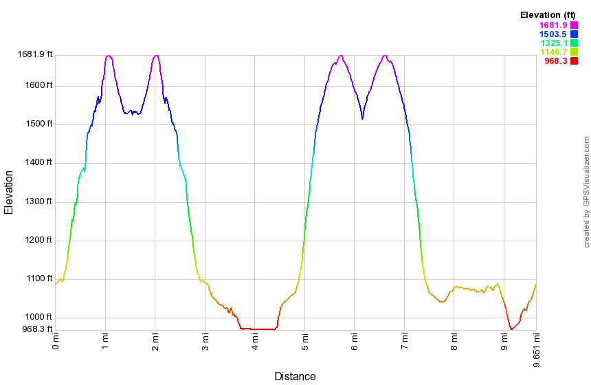 (The image at the left shows the profile of the hike. Remember that all vertical profiles are relative!)
Finger Lakes Trail: Braley Hill Road to Old 76 Road
| Quick Look | ||||
|---|---|---|---|---|
| Difficulty | Round trip | Total climb | Internet Maps | |
| 10.5 mi | 2097 ft. | AllTrails | ||
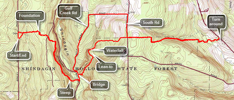 The Finger Lakes Trail is a primitive footpath that starts in Allegheny State Park on the New York - Pennsylvania border and extends 576.5 miles to end in the Catskill Park at the beginning of the Table Peekamoose Trail off the Phoenicia East Branch Trail near the Denning trailhead. There are other side trails which increase the length of the trail system. Four hundred miles of this trail is also part of the Scenic North Country Trail. The Finer Lakes Trail Conference celebrated its 50th Anniversary on June 2, 2012. To commemorate the occasion the Conference set up a series of hikes that would cover the entire length of the trail. Hikes varied in length and difficulty from 4 to 14 miles. The Trail Conference continues to improve the trails and to move sections from roads to trails.
This hike can be done with a car spot since it is 10.5 miles round trip but it can easily be done as a loop using local roads for part of the return trip. The route described here employs that method. Take I81 to the Whitney Point exit, exit 8. Follow Route 79 west from Whitney Point toward Ithaca for a little over 20 miles and then turn left on Boiceville Road. After .6 miles, turn left on Central Chapel Road and then stay to the right on Braley Hill Road after 2.6 miles. Pass by the first big parking area on the left which is marked for Shindagin Hollow State Forest. Park in the next parking area on the left. Head south on Braley Hill Road for only 250 feet before turning left into the woods on the Finger Lakes Trail. The trail descends slightly to cross two small streams and then a larger one at .2 miles where there is a bivouac area. At .7 miles cross a jeep trail and continue across to the other side where you will pick up the white blazes again. Continue to descend, passing an old foundation at .8 miles. The trail makes a sharp right after this and we begins to parallel Shindagin Hollow Road some 200 feet above it with a steep dropoff to the left. At 1.5 miles begin to descend off the ridge to the road. When you come to the road at 1.8 miles you will be at the lowest spot on the hike at about 1180 feet. Turn left and walk about 500 feet up the road where you should turn right and cross the stream on a bridge. From here the trail begins to ascend again on logging road. Several of the turns are simply not marked at all so watch carefully for the blazes! At 2.5 miles enter the area surrounding the Shindagin Hollow lean-to. The area is large including the lean-to, a privy and several fire rings. The trail passes in front of the lean-to and parallels a stream. Just after the lean-to is a small cascade which tumbles over some exposed bedrock. The trail has been heading us north but now turns east and continues ascending to South Road. Along the way there were two interesting arrangements of stones. One is almost a stone wall incorporating a downed tree. The other is a large cairn. Continue on to South Road. Cross the road to a nice country lane which is wide and well-maintained. At 3.4 miles you will be at the highest point on then hike at almost 1800 feet and you will start a long descent toward Old 76 Road. At 3.6 miles the country lane ends and the trail turns to the right and continues almost due east. Continued to descend to 4.7 mile where you cross Boyer Creek on a bridge. Continue to head east and descend to Old 76 Road at 4.9 miles. Walk across the road to connect with next section. Turn around and hike back to South Road on the trail. At 6.6 miles turn right on South Road and hike north .4 miles to a left turn on Gulf Creek Road. The road heads due west and then south for 1.7 miles to Shindagin Hollow Road. It also drops over 500 feet which must be regained to get to your car. Turn left on the road and hike back to where the trail heads back up the ridge retracing your route from earlier. There are three climbs to get back to Braley Hill Road with the first being the most sustained at 340 feet. As you approach the parking area you can continue back on the Finger Lakes Trail or turn right on the blue trail which brings you out to the road just north of the parking area.
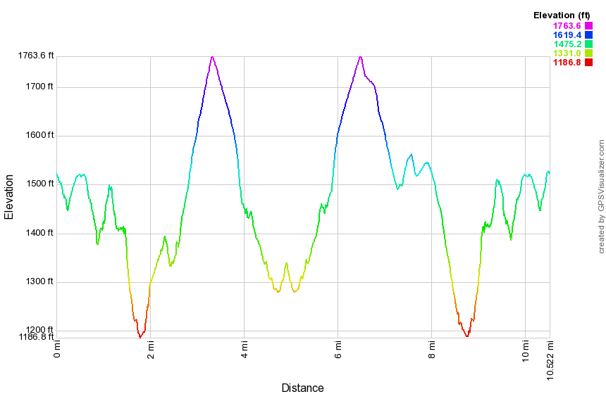 (The image at the left shows the profile of the hike. Remember that all vertical profiles are relative!)
Finger Lakes Trail: Old 76 Road to Route 79
| Quick Look | ||||
|---|---|---|---|---|
| Difficulty | Round trip | Total climb | Internet Maps | |
| 11.6 mi | 1416 ft. | AllTrails | ||
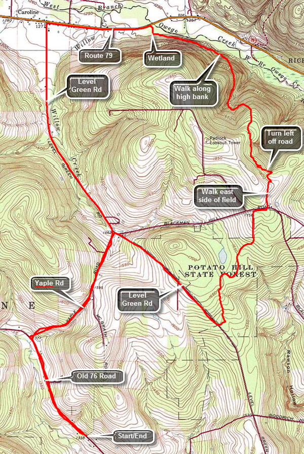 The Finger Lakes Trail is a primitive footpath that starts in Allegheny State Park on the New York - Pennsylvania border and extends 576.5 miles to end in the Catskill Park at the beginning of the Table Peekamoose Trail off the Phoenicia East Branch Trail near the Denning trailhead. There are other side trails which increase the length of the trail system. Four hundred miles of this trail is also part of the Scenic North Country Trail. The Finer Lakes Trail Conference celebrated its 50th Anniversary on June 2, 2012. To commemorate the occasion the Conference set up a series of hikes that would cover the entire length of the trail. Hikes varied in length and difficulty from 4 to 14 miles. The Trail Conference continues to improve the trails and to move sections from roads to trails.
This hike can be done with a car spot since it is 10.4 miles round trip but it can easily be done as a loop using local roads for the return trip. The route described here is the loop! Much of this trail is unmaintained and sparsely marked. Keep a close eye on the blazes at all times and be prepared to search for the next marker. A map, compass and description of the trail is mandatory. A GPS unit is helpful. Take I81 to the Whitney Point exit, exit 8. Follow Route 79 west from Whitney Point toward Ithaca for a little over 13 miles and then turn left on West Creek Road. Eventually this road becomes Old 76 Road in Speedsville. Head northwest for 2.6 miles from the STOP sign in Speedsville watching for McGrath Road on the right. This is an abandoned road and there is little indication of its location except for a slightly wider spot in the road. The Finger Lakes Trail crossing is also poorly marked. Pull over and park on the east side of the Old 76 Road. The trail from Old 76 Road to Level Green Road is now closed by the removal of landowner permission. Walk .9 miles northwest on Old 76 Road. Turn right on Yaple Road and walk 1.2 miles northeast to the intersection with Blackman Hill Road and Level Green Road. Turn right and stay right on Level Green Road. Walk 1.1 miles southeast on Level Green Road to where the trail crosses the road. Turn left onto the trail. Start your hike my entering the woods on what is left of McGrath Road which is a rocky and usually muddy and wet mess. Continue on this "road" following whatever blazes you can until about .45 miles. Turn right onto a woods road and follow some blazes to .7 miles. The road turns right here but you should continue straight ahead on a sort of "lane". This can be hard to spot depending on the condition of the blazes and the amount of trail maintenance that has been done. At about .9 miles you will come to a to a stream and the blazes again don't help much. Turn left and cross the stream to a path that climbs a hill. There are no blazes that can be seen from the other side! The trail is now was obvious but there are only a few blazes. Enter an evergreen forest which is part of Potato Hill State Forest. The trail here it in better condition and the blazes are easier to see but little maintenance has been done. At just under 2 miles cross Level Green Road which at this point is a dirt road. Continue to walk along the trail gaining elevation slightly heading north. At 4.35 miles the trail approaches Blackman Hill Road and runs parallel until crosses the road at 4.45 miles. The trail on the other side follows a short road or driveway and then enters a field. Follow the eastern edge of the field to the northeast corner. Walk to the left or northeast along the edge of the field until you find the trail on the left. The trail begins to follow a well-defined logging road which makes several twists and turns. At 4.9 miles the trail begins to leave the logging road to the left. Be careful to follow the blazes and not the road! At 5.2 miles begin a descent that ends up at Route 79. The woods road may be wet but is a least well blazed. At 5.9 miles we begin to walk along the bank of West Owego Creek high above the water. The descent continues with a few short climbs along the way. The trail is barely etched into the side of the hill doesn't seem to get much use from hikers. At 6.7 miles turn right following the blazes toward Route 79. There is a nice bridge and a walkway over a wet and marshy area. Walk out to Route 79 and turn left to walk to Level Green Road for the trip back. It is .85 miles to the left turn onto Level Green Road. When you turn left, you will see a long stretch of rather flat road ahead. From Route 79 to Blackman Hill Road is about 1.85 miles and there is, in fact, a slight ascent of about 200 feet. At 9.5 miles we turn right on Yaple Road and continue to climb until the road begins to descend to Old 76 Road at 10.6 miles. Turn left onto Old 76 Road and walk another .9 miles to your car.
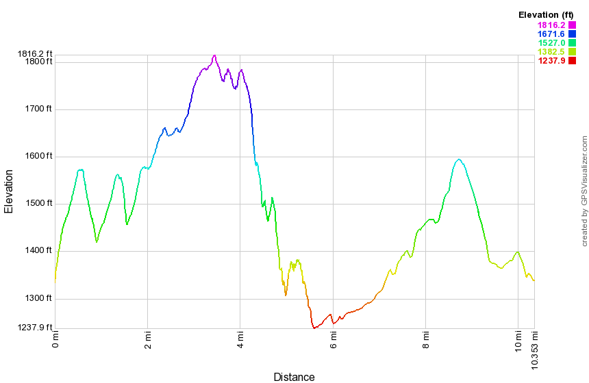 (The image at the left shows the profile of the hike. Remember that all vertical profiles are relative!)
Finger Lakes Trail: Route 79 to Purvis Rd
| Quick Look | ||||
|---|---|---|---|---|
| Difficulty | Round trip | Total climb | Internet Maps | |
| 14.8 mi | 2370 ft. | AllTrails | ||
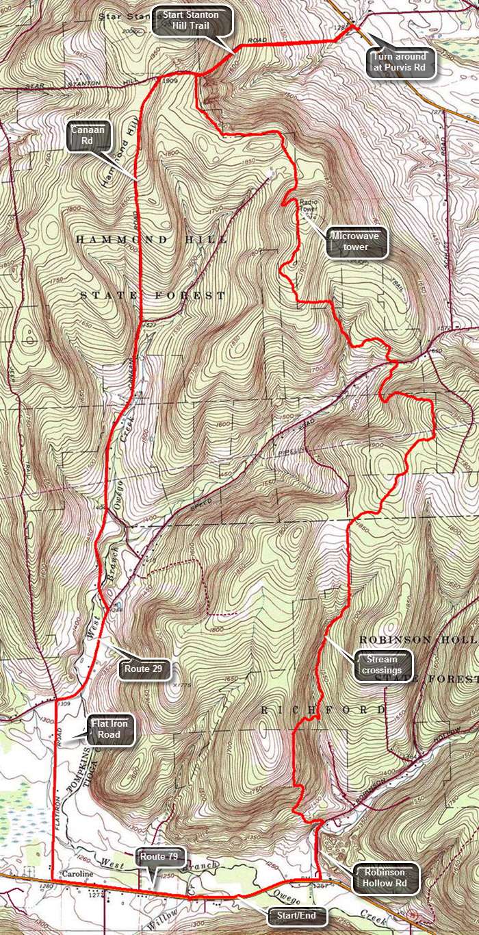 The Finger Lakes Trail is a primitive footpath that starts in Allegheny State Park on the New York - Pennsylvania border and extends 576.5 miles to end in the Catskill Park at the beginning of the Table Peekamoose Trail off the Phoenicia East Branch Trail near the Denning trailhead. There are other side trails which increase the length of the trail system. Four hundred miles of this trail is also part of the Scenic North Country Trail. The Finer Lakes Trail Conference celebrated its 50th Anniversary on June 2, 2012. To commemorate the occasion the Conference set up a series of hikes that would cover the entire length of the trail. Hikes varied in length and difficulty from 4 to 14 miles. The Trail Conference continues to improve the trails and to move sections from roads to trails.
This hike can be done with a car spot since it is 14.8 miles round trip and has some elevation gain. The route described here is a loop using roads for the return trip! Take exit 8 on I-81 and head west on Route 79 for about 15.5 miles to Robinson Hollow Road on the right. Drive passed the road and park in the snowplow turnaround on the other side of a stream. DO NOT park here during months when there is snow or your car may be towed! Start walking east on Route 79 toward Robinson Hollow Road for .4 miles. Turn left on Robinson Hollow Road and walk about .4 miles. After crossing a road bridge, Robinson Hollow Road bends to the right. At this point the trail turns off the road to the left. Start to climb a woods road that gains 450 feet in the first .5 miles for a 15% grade. The trail may be very wet in spots especially after rain. The trail is well-marked in most spots and you won't have to stop and guess where you should go next. After climbing, the trail drops down to a stream bed and starts crossing it several times. Continue to follow the stream until 2.4 miles climbing slightly along the way until the trail crosses the stream again heading mostly north. The trail climbs heading north with a few swings to avoid steep climbs or other obstacles. At 3.7 miles the trail reaches 1950 feet and begins to descend to the Harford-Slaterville Road or Route 117. Cross the road to stay on the trail and continue north crossing another stream at about 4.8 miles. The trail begins an ascent to 2015 feet which is the highest point on this route. At the high point there is a microwave facility to the right of the trail. Begin a slight descent to Star Stanton Hill Road which at about 7.1 miles. The "road" is little more than a washed out gully. Turn right and follow the trail downhill for about a mile to Route 38. Turn right on the main road and then immediately left on Purvis Road. This is the end of map section 18. Turn around to return the way you came up the hill on the trail. At the point where the trail turns left off the "road", continue straight ahead to Canaan Road. The trail markings indicate a snowmobile trail and it is a short walk to a trail junction with clear signage. A sign points south with a label for "Caroline 6 miles" and Canaan Road. Canaan Road is an abandoned town road which is now part of the Hammond Hill State Forest. At 10.6 miles Red Man Run Road comes in from the left. Continue south on Canaan Road without turning and in another half mile the road becomes paved. At 11.7 miles pass Luddington road on the left and continue downhill to 12.2 miles. Turn right on Harford Road or Route 29 and walked west to Flat Iron Road where you should turn left at 12.8 miles. Route 79 is about a mile away but the road is so straight and flat you can see all the way to your next turn. This road is flanked by farms and on the right side by the Goetchius Wetland Preserve. This is an 80 acre preserve owned by the Finger Lakes Land Trust in Tompkins County. The wetlands drain both to the north and south. At Route 79, turn left or east and start to hike the last mile back to the car. The road has a wide shoulder which was fortunate since the traffic seems to travel somewhat above the speed limit!
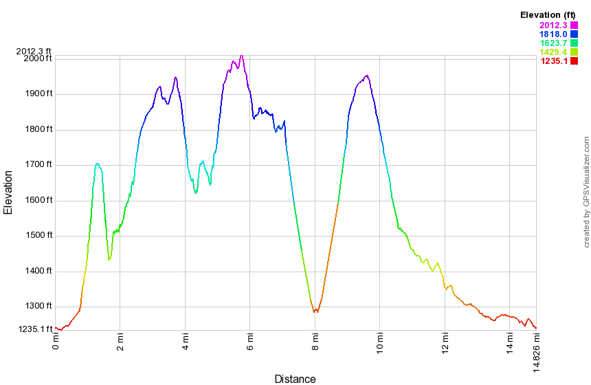 (The image at the left shows the profile of the hike. Remember that all vertical profiles are relative!)
Finger Lakes Trail: Purvis Rd to Owego Hill Rd
| Quick Look | ||||
|---|---|---|---|---|
| Difficulty | Round trip | Total climb | Internet Maps | |
| 11.7 mi | 1710 ft. | AllTrails | ||
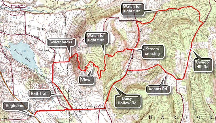 The Finger Lakes Trail is a primitive footpath that starts in Allegheny State Park on the New York - Pennsylvania border and extends 576.5 miles to end in the Catskill Park at the beginning of the Table Peekamoose Trail off the Phoenicia East Branch Trail near the Denning trailhead. There are other side trails which increase the length of the trail system. Four hundred miles of this trail is also part of the Scenic North Country Trail. The Finer Lakes Trail Conference celebrated its 50th Anniversary on June 2, 2012. To commemorate the occasion the Conference set up a series of hikes that would cover the entire length of the trail. Hikes varied in length and difficulty from 4 to 14 miles. The Trail Conference continues to improve the trails and to move sections from roads to trails.
This hike can be done with a car spot since it is 11.7 miles round trip and has some elevation gain. The route described here is a loop using roads for the return trip! Take exit 9 on I-81 and head west on Route 221 to the junction with Route 38. Turn right and drive north for 2.5 miles. Turn right on Purvis Road and park on the widest part of the shoulder on the right side of the road. Begin the hike by walking east on Purvis Road for .6 miles and then turn right on Willow Crossing. After crossing a road bridge, there is a small parking area on the left. This is part of the Jim Schug Trail which is a rail trail. The Finger Lakes Trail uses a small part of the rail trail. Turn left onto the trail which is absolutely flat and smooth and well maintained. At 1.4 miles turn right on Lake Road where the rail trail continues straight. Hike to 1.7 miles where the trail enters a field between two houses. A track is mowed between the two houses and heads due east toward a hill. The trail may be wet and muddy in spots but it is easy to follow. Just before starting into the woods, turn around for a nice view including Dryden Lake. The trail up the hill has many switchbacks which makes the path less steep but adds to the distance. Not far into the woods was a very large oak tree with a Finger Lakes Trail register on one side. Continue to the top of the hill heading generally eastward. There is a Field View Trail on the right which you may ant to investigate. At 3.25 miles there is a nice lookout on the right side of the trail which you can get to by walking through the woods to an opening. Continue to hike back on the main trail. Be aware that the land you are traveling on is private and landowners have given permission for the Finger Lakes Trail Conference to use the land. The trail can be extremely wet and muddy. The trail is not as well marked as the eastern portion and blazes are few and far between with turns not clearly marked. At 4.2 miles be careful not to miss the point where the trail turns right just before the power line right-of-way. Follow the trail through some areas which can be very wet as it descended the hill roughly paralleling the right-of-way. Eventually the trail crosses under the power line in a swampy area. Continue to follow the trail through many twists and turns and switchbacks heading east toward Daisy Hollow Road. As you approached the road, the trail descends to a stream. The trail is highly eroded and there are few no white blazes. Down by the stream there are some blazes. Cross the stream and arrive at Daisy Hollow Road. Turn left on Daisy Hollow Road and walk .6 miles up a hill. At 5.55 miles turn right off the road and enter the woods for about a 2 mile hike to Owego Hill Road. The trail continues heading east paralleling an intermittent stream. At about 6.15 miles watch for the point where the trail turns right and crosses a stream. The turn may not be marked and the turn is easy to miss! Continue to follow the trail east paralleling the stream and gaining some elevation. Followed the trail as it turns south at about 6.8 miles crossing a small stream. At 7.2 miles the trail crosses Owego Hill Road which is definitely a "seasonal maintenance only". Turn right and follow the road to 8.5 miles and turn right on Adams Road. Follow Adams Road for about 1 mile to the intersection with Daisy Hollow Road. Turn left and follow Daisy Hollow Road .9 miles to Willow Crossing. Turn right and walk .7 miles to Purvis Road passing the rail trail on the way. Turn left on Purvis Road and walk .6 miles back to your car.
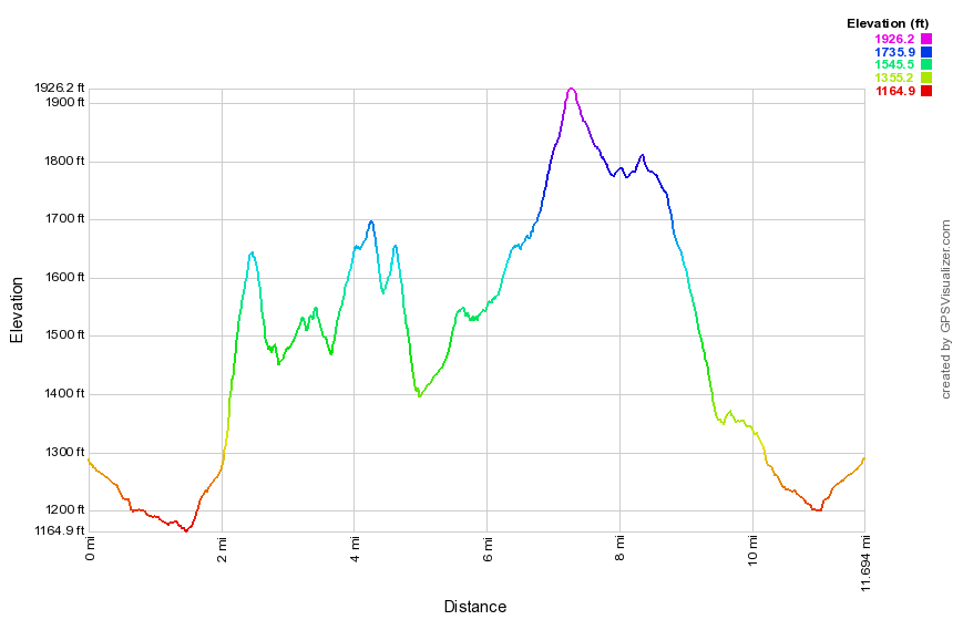 (The image at the left shows the profile of the hike. Remember that all vertical profiles are relative!)
Finger Lakes Trail: Bleck Rd to Owego Hill Rd
| Quick Look | ||||
|---|---|---|---|---|
| Difficulty | Round trip | Total climb | Internet Maps | |
| 7.7 mi | 1585 ft. | AllTrails | ||
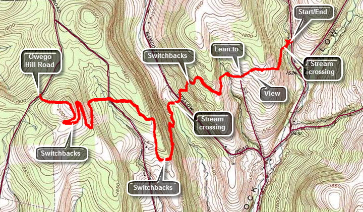 The Finger Lakes Trail is a primitive footpath that starts in Allegheny State Park on the New York - Pennsylvania border and extends 576.5 miles to end in the Catskill Park at the beginning of the Table Peekamoose Trail off the Phoenicia East Branch Trail near the Denning trailhead. There are other side trails which increase the length of the trail system. Four hundred miles of this trail is also part of the Scenic North Country Trail. The Finer Lakes Trail Conference celebrated its 50th Anniversary on June 2, 2012. To commemorate the occasion the Conference set up a series of hikes that would cover the entire length of the trail. Hikes varied in length and difficulty from 4 to 14 miles. The Trail Conference continues to improve the trails and to move sections from roads to trails.
This hike can be done as an out and back as it is only 7.7 miles round trip. Take exit 9 on I-81 and head west on Route 221 for about 11 miles to Babcock Hollow Rd on the right. Turn right and drive north to where Bleck Road branches to the right. Turn right and drive about 1 mile to where the Finger Lakes Trail crosses the road. Park on the wider shoulder on the west side of the road. Begin the hike by entering the woods on the west side of the road and walking down an incline to a stream crossing. There is no bridge and the crossing can be difficult when the water is high. Parts of this trail can be very slick and slippery when they are wet! There may be standing pools of water, areas where the trail is more of a streambed and many areas of slick mud. At about .5 miles ascend a hill and find a view to the south. Just after this view is the Foxfire lean-to on the right side of the trail. Descend a little just passed the lean-to and then began an ascent to the top of a small hill. From there descend 240 feet through some switchbacks to Babcock Hollow Road. Cross the road and continue to descend to another stream crossing which lacks a bridge. On the other begin a 1 mile switchback as you head toward Hilsinger Road. The direct route is only .2 miles but has an elevation gain of 350 feet! A sign just before the switchback warns that there are steep areas ahead that can be slippery when wet! The sign mentions that there are ropes on the steepest parts. There are 3 ropes but hiking poles may be enough. Parallel Hilsinger Road for some time until at 2.5 miles the trail turns toward it and reaches the road at 2.6 miles. It is barely a road at this point. From Hilsinger Road to Owego Hill Road is only .5 miles but the trail covers 1.25 miles of switchbacks to get there. There doesn't seem to be any need for the wandering back and forth as the grade on the direct route is more than manageable! Along the way on the Finger Lakes Trail there are several different side loops which are marked in different colors. At 3.65 miles is the highest point of the hike at 2032 feet on top of some unnamed hill. From here descend to Owego Hill Road at 3.9 miles. Turn around and begin to retrace your steps back up the hill and then down through the switchbacks. It is possible to walk down Hilsinger Road to Babcock Hollow Road and then north to Bleck Road and your car but it adds a lot of mileage. Again, when crossing Babcock Hollow Road you may walk south to the junction with Bleck Road but this route adds some distance but may be quicker under certain conditions. The shortest distance back to your car is to follow the trail being careful on some of the steeper descents.
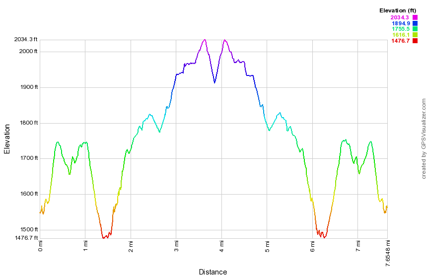 (The image at the left shows the profile of the hike. Remember that all vertical profiles are relative!)
Finger Lakes Trail: Bleck Rd to Carson Rd
| Quick Look | ||||
|---|---|---|---|---|
| Difficulty | Round trip | Total climb | Internet Maps | |
| 14.3 mi | 2095 ft. | AllTrails | ||
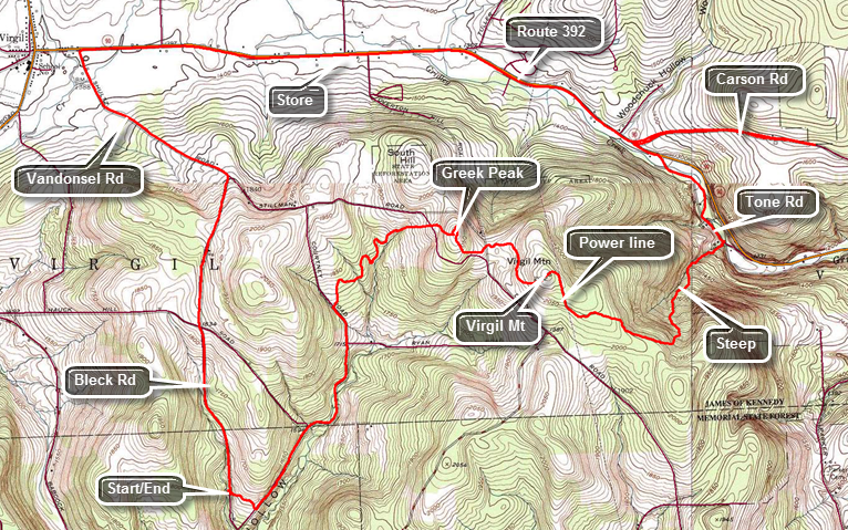 The Finger Lakes Trail is a primitive footpath that starts in Allegheny State Park on the New York - Pennsylvania border and extends 576.5 miles to end in the Catskill Park at the beginning of the Table Peekamoose Trail off the Phoenicia East Branch Trail near the Denning trailhead. There are other side trails which increase the length of the trail system. Four hundred miles of this trail is also part of the Scenic North Country Trail. The Finer Lakes Trail Conference celebrated its 50th Anniversary on June 2, 2012. To commemorate the occasion the Conference set up a series of hikes that would cover the entire length of the trail. Hikes varied in length and difficulty from 4 to 14 miles. The Trail Conference continues to improve the trails and to move sections from roads to trails.
This hike can be done with a car spot since it is 14.3 miles round trip and has some significant elevation gain. The route described here is a loop using roads for the return trip! Take exit 9 on I-81 and head west on Route 221. In about 11 miles turn right on Babcock Hollow Road. In 1.8 miles bear right onto Bleck road and drive about 1 mile. Watch for the Finger Lakes Trail sign on the left side of the road. Turn around and park on the west shoulder of the road. Cross the road to begin your hike by walking up a small hill through some pines. Within less than a quarter mile the trail splits with the blue Kuzia Cutoff going left. Stay to the right on the main Finger Lakes Trail and it will soon cross Cortwright Road. The road is a woods road and the trail parallels it. The road acts as a high water bypass as the trail makes several stream crossings which may be difficult. The mileage is almost exactly the same. Turn left on the road and continue uphill for about 1.2 miles where Baldwin Road comes in on the right. At this point Cortwright Road starts to be more navigable and the main FLT comes in from the right. Continue on the road for another .2 miles to 1.6 miles where the trail crossed the ditch on the right on a small bridge and then starts an ascent of 1.2 miles to the top of the Greek Peak Ski Area. The trail heads generally northeast with a few twists and turns and even some slight descents on the way. At about 2.75 miles you should be able to see the ski lifts from the trail. You may want to walk over to the lifts to get a view to the north. Return to the trail to begin the walk to Virgil Mountain, the highest peak in the area. The drop between the two peaks is just over 100 feet. Pass the highest point which has no views and descend to a power line. There are views from here but none are spectacular especially since the power line dominate the views. Turn right to follow the right-of-way. for about .2 miles where a sign indicates that the main Finger Lakes Trail turns to the left. The yellow blazed Virgil Mountain Trail turns off to the right. Turn left to stay on the Finger Lakes Trail and get ready for the steepest descent of the day. You will lose 800 feet in the 1.3 miles from the turn to Tone Road at the bottom of the mountain. The trail at first heads ESE but at 4.5 miles turns northeast and the descent becomes steeper. At some point you will come to a steam boiler on the right side of the trail. Some stories mentioned that it is from a railroad engine but it was more likely part of a stationary installment. Continued to descend to Tone Road making a stream crossing just before the road. Walk north along Tone Road which runs parallel to Route 392 but on the other side of Gridley creek. At 6 miles cross the creek on a road bridge, turn left and walk up the road a few hundred feet to Carson Road. Turn right and hike uphill for 1 mile to the wide spot in the road where the trail enters the woods on the left. Immediately turn around and walk back Route 392. Turn right on Route 392 and walk west for 3.2 miles to Vandonsel Road. The route is almost flat and the shoulder of the road is wide although the traffic is always well above the speed limit. Very soon after starting out on Route 392 pass the Greek Peak Ski Area. There are lodges and a convention center and chair lifts that climb the hill. There was also a small zip line! Pass a small convenience store on the left and continue until you get to Vandonsel Road on the left. The road climbs to near the top of the ridge to the right turn onto Bleck Road. Turn right onto Bleck Road which continues to climb before a descent to the car. There is no way to avoid this climb of about 420 feet. It isn't a steep climb but you may be tired by this time. When you finally hit the top and start down it is only a short distance back to your car.
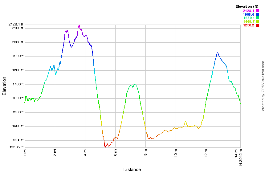 (The image at the left shows the profile of the hike. Remember that all vertical profiles are relative!)
Finger Lakes Trail: Carson Rd to West River Rd
| Quick Look | ||||
|---|---|---|---|---|
| Difficulty | Round trip | Total climb | Internet Maps | |
| 9.7 mi | 940 ft. | AllTrails | ||
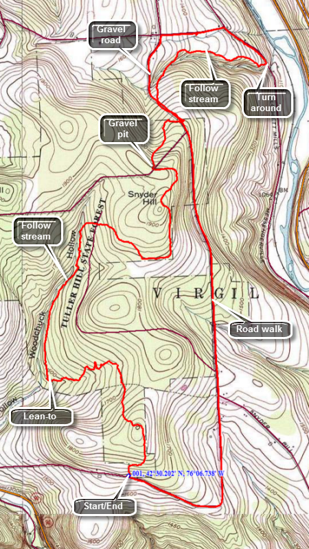 The Finger Lakes Trail is a primitive footpath that starts in Allegheny State Park on the New York - Pennsylvania border and extends 576.5 miles to end in the Catskill Park at the beginning of the Table Peekamoose Trail off the Phoenicia East Branch Trail near the Denning trailhead. There are other side trails which increase the length of the trail system. Four hundred miles of this trail is also part of the Scenic North Country Trail. The Finer Lakes Trail Conference celebrated its 50th Anniversary on June 2, 2012. To commemorate the occasion the Conference set up a series of hikes that would cover the entire length of the trail. Hikes varied in length and difficulty from 4 to 14 miles. The Trail Conference continues to improve the trails and to move sections from roads to trails.
This hike can be done with a car spot but it is only 9.7 miles round trip. The route described here is a loop using roads for the return trip! Take exit 9 on I-81 and head north on Route 11. In about 4 miles turn left on Route 392. In 4 more miles make a sharp right turn on Carson Road and drive about 1 mile. Watch for the Finger Lakes Trail sign on the left side of the road. Turn around and park on the north shoulder of the road. Head out on the Finger Lakes Trail through Tuller Hill State Forest. The trail starts north through some hardwoods and climbs a little hill before descending down the other side. Around .85 miles the trail turns east and continues to descend. At 1.45 miles you will come to the edge of a stream called Neal Brook and pass the Woodchuck Hollow lean-to where the trail turns again to head north. For the next mile the trail follows the brook north climbing a little until, at 2.5 miles, it turns east and shortly thereafter crosses the Cortland Nine Road. The soil in the area has a large percentage of clay and can be very slippery especially when wet. Some of the little stream crossings have descents that are very steep and equally challenging climbs out of the stream bed on the other side. After crossing the road, the trail continues to ascend but now heads east. At 3.1 miles the trail turns north toward Snyder Hill which is not much of a climb. At 3.8 miles you will come to a cleared spot at the upper end of Pipeline Road. Watch for the blazes along the right edge of the clearing. Continue to descend a little heading northeast until you cross Snyder Hill Road at 4.25 miles. The trail turns northwest and parallels the road before heading northeast and crossing a brook. From this point on you will hear the traffic on I-81 and on a clear day you can see Hoxie Gorge Bridge. You will approach a field, walk along the edge and then return to the woods to walk parallel to another stream. The blazes here are a little confusing but you should be able to spot their general direction. The trail continues to descend as you approach West River Road and even passes through the backyard of a private residence. When you reach West River Road turn left and hike northwest on West River Road for about .3 miles gaining elevation as you go. Turn left on Stafford Road and hike another .4 miles to Snyder Hill Road. Turn left on Snyder Hill Road and hike about 2.3 mile trip south passing over two small hills. At 8.5 miles Snyder Hill Road veers to the left but continue straight ahead on Carson Road. There are several nice farms along the way, some interesting private residences and evidence of some logging operations. Carson Road eventually makes a 90 degree turn to the right and after that you will soon be back at the car.
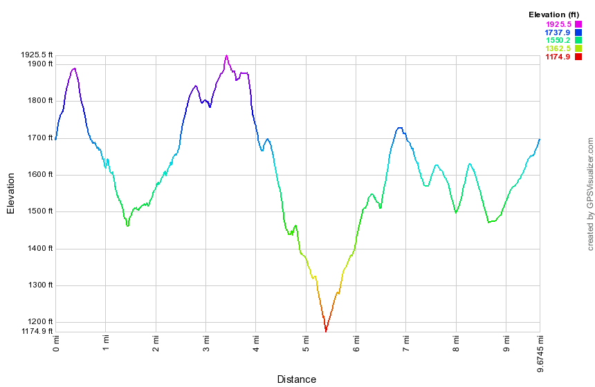 (The image at the left shows the profile of the hike. Remember that all vertical profiles are relative!)
Finger Lakes Trail: West River Rd to Steve Russell Hill Rd
| Quick Look | ||||
|---|---|---|---|---|
| Difficulty | Round trip | Total climb | Internet Maps | |
| 11.6 mi | 740 ft. | AllTrails | ||
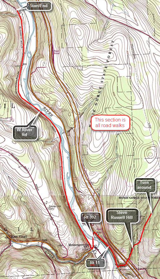 The Finger Lakes Trail is a primitive footpath that starts in Allegheny State Park on the New York - Pennsylvania border and extends 576.5 miles to end in the Catskill Park at the beginning of the Table Peekamoose Trail off the Phoenicia East Branch Trail near the Denning trailhead. There are other side trails which increase the length of the trail system. Four hundred miles of this trail is also part of the Scenic North Country Trail. The Finer Lakes Trail Conference celebrated its 50th Anniversary on June 2, 2012. To commemorate the occasion the Conference set up a series of hikes that would cover the entire length of the trail. Hikes varied in length and difficulty from 4 to 14 miles. The Trail Conference continues to improve the trails and to move sections from roads to trails.
This hike is best done with a car spot since it is 5.8 miles one way for a total of 11.6 miles and because the scenery is not that interesting. The route described here is strict out and back without any variations. Take Route 11 north from Marathon for a little more than 7 miles toward Cortland. Watch for Route 392 on the left. Turn left on 392 and then make the next right onto West River Road. The road is dirt and gravel with some large potholes. Drive 3.8 miles until you see where the Finger Lakes Trail crosses the road. Park on the right side just passed the guard rails. Hike south on West River Road for 3.9 miles. The road does not get much traffic and parallels the railroad tracks and Tioughnionda River for the entire distance. Turn left on Route 392 and walk east crossing the river on the road bride. At Route 11 turn right or south and hike along the wide shoulder of the road. Be careful as the traffic here is heavy and fast moving. Just after .6 miles, watch for Steve Russell Hill Rd on the left.Tturn left on the dirt and gravel road and begin a mostly gentle ascent that lasts until you turn around at 5.8 miles. At 4.9 miles pass under the high bridges of I81. Just after these bridges the road splits with the better road turning to the right. Continue straight ahead for another .8 miles to the point where the Finger Lakes Trail enters the forest on the left. Turn around and retrace your route if you do not have a car parked at this end.
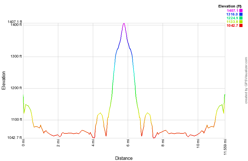 (The image at the left shows the profile of the hike. Remember that all vertical profiles are relative!)
Finger Lakes Trail: Steve Russell Hill Rd to Hoxie Gorge
| Quick Look | ||||
|---|---|---|---|---|
| Difficulty | Round trip | Total climb | Internet Maps | |
| 9.8 mi | 1565 ft. | AllTrails | ||
The Finger Lakes Trail is a primitive footpath that starts in Allegheny State Park on the New York - Pennsylvania border and extends 576.5 miles to end in the Catskill Park at the beginning of the Table Peekamoose Trail off the Phoenicia East Branch Trail near the Denning trailhead. There are other side trails which increase the length of the trail system. Four hundred miles of this trail is also part of the Scenic North Country Trail. The Finer Lakes Trail Conference celebrated its 50th Anniversary on June 2, 2012. To commemorate the occasion the Conference set up a series of hikes that would cover the entire length of the trail. Hikes varied in length and difficulty from 4 to 14 miles. The Trail Conference continues to improve the trails and to move sections from roads to trails.
This hike can be done with a car spot since it is 4.9 miles one way for a total of 9.8 miles and because the scenery is not that interesting. The route described here a loop using local roads for the return trip. Take Route 11 north from Marathon for 3.5 miles to Steve Russell Hill Road on the right. Turn right onto this dirt and gravel road and pass under the high bridges for I81. Where the road splits continue straight ahead passing the "seasonal Maintenance" sign. Be careful as you drive up the road as there are some deep gullies and large rocks. Once I even encountered a tree that had just fallen across the road. Find where the Finger Lakes Trail enters the woods on the left. Park in the wide spot on the left shoulder. This trail can be slippery when wet and insect repellant is a good idea. If you hike with a dog, note the sign that warns about high porcupine activity. The trail initial drops to a stream heading northwest and is well-marked in most places. At .8 miles cross a small stream on a bridge and arrive at a nice pond. After the pond he trail descends on some steps and meanders back and forth and up and down turning north at 1.2 miles. Continue to cross small streams walking up and down some hills. The traffic noise from I81 is obvious and you may be able to see the cars on the highway. Somewhere between 2 and 3 miles the blazing seems to change for the worse. Some turns were not well-marked and the blazes become harder to spot and farther apart. At 3 miles begin an ascent of 350 feet and at 3.9 miles pick up a woods road that leads to a DEC dirt road. Walk along the road and hit the high point of the hike at 1770 feet 4.2 miles into the hike. From here the road descends to the Hoxie Gorge Freetown Road at 4.8 miles. Cross the road to continue the hike to where the old trail used to come in from Hoxie Gorge Road. The trail is more of the same thing you have been hiking with several small stream crossings. Somewhere around 5.3 miles the trail joins a nice woods road and turns right to parallel a more substantial stream. As you walk along this road, notice several small cascades. You will pass a Cornell University Environmental sign as you near your destination. Arrive at an area where a stream spread across the trail and the main Finger Lakes Trail turns right while a Cornell trail goes left. The trail that goes to the left used to be the main Finger Lakes Trail before the newest reroute. At this junction there is also an old stone bridge with a large culvert underneath it. Turn around to head back to Hoxie Gorge Freetown Road. Turn left and start to hike southeast along the road. At At 8 miles turn right on Merihew Road. Turn right onto Steve Russell Hill Road at 8.8 miles to complete the loop. Walk uphill for about a quarter mile and then downhill the final .7 miles to the car>
(The image at the left shows the profile of the hike. Remember that all vertical profiles are relative!)
Finger Lakes Trail: Hoxie Gorge Road to Baker Schoolhouse Road (bypass)
| Quick Look | ||||
|---|---|---|---|---|
| Difficulty | Round trip | Total climb | Internet Maps | |
| 12.2 mi | 1830 ft. | AllTrails | ||
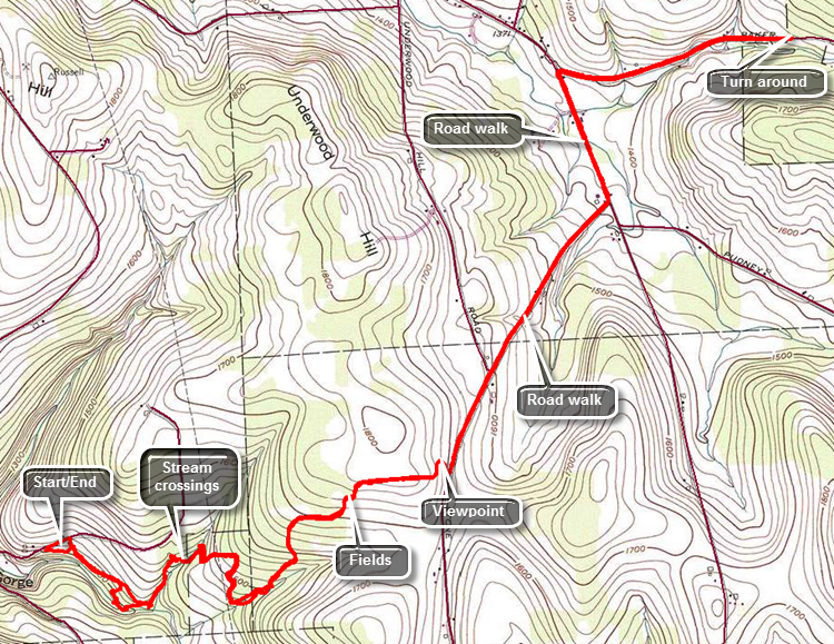 The Finger Lakes Trail is a primitive footpath that starts in Allegheny State Park on the New York - Pennsylvania border and extends 576.5 miles to end in the Catskill Park at the beginning of the Table Peekamoose Trail off the Phoenicia East Branch Trail near the Denning trailhead. There are other side trails which increase the length of the trail system. Four hundred miles of this trail is also part of the Scenic North Country Trail. The Finger Lakes Trail Conference celebrated its 50th Anniversary on June 2, 2012. To commemorate the occasion the Conference set up a series of hikes that would cover the entire length of the trail. Hikes varied in length and difficulty from 4 to 14 miles. The Trail Conference continues to improve the trails and to move sections from roads to trails.
This hike is best done with a car spot since it is 5.2 miles one way for a total of 10.4 miles. The route described here is out and back with a little variation thrown in! Take Route 11 north from Marathon for about 8 miles toward Cortland. Watch for Hoxie Gorge Road on the right and turn onto this road. Drive about .8 miles and park near where the blue-blazed side trail enters the woods. To get to the main Finger Lakes Trail, follow the blue blazes for about .75 miles to an old stone bridge. SUNY Cortland has a "campus" on this road where they do environmental studies and their trail is marked with yellow markers. They also have number on the markers which must correspond to the types of trees and bushes. From this point on the trail is blazed white for the Finger Lakes Trail but follows the Cortland trail for a while and crosses several small tributaries. There is a good amount of walking up and down especially when crossing these small streams. The forest begins to transition from evergreens to hardwoods as the trail heads generally east and northeast. At about 1.7 miles you will start walking through some brush and weeds on the edge of a field and come out on a woods road. Continue to walk north a little then northeast and then turn almost due east when you come to the edge of a corn field. As you walk along the south edge of the field you will come to a spot where the trail makes a 90 degree turn to the left at about 2.4 miles. A sign explains that the trail is closed at this point for hunting during certain times. To take the hunting bypass do NOT turn left but continue along the fields and out to Stone Road. As you walk toward the road you may find a nice viewpoint over the corn fields and surrounding countryside. Turn left and head northeast on Stone Road for about .4 miles where the name changes to Atkins Road and Underwood Hill Road goes off to the left. Continue to walk another .75 miles mostly downhill to the McGraw Marathon Road. Turn left to head north passing several small farms on the way. It is .5 miles to a right turn onto Baker Schoolhouse Road. After .9 miles, the Finger Lakes Trail cuts off the road to the left which marks the end of this section of the trail. If you have a car parked here, you have finished your hike. If your only car is back on Hoxie Gorge Road, retrace your route back to where you are parked. When you get to the yellow marked Cortland trails, you may simply follow them out to the road. This is a nice alternative and the trails are a little better maintained than the Finger Lakes Trail. You will break out onto Hoxie Gorge Road just above where you entered the woods and near where your car is parked.
 (The image at the left shows the profile of the hike. Remember that all vertical profiles are relative!)
Finger Lakes Trail: Baker Schoolhouse Road to Telephone Road
| Quick Look | ||||
|---|---|---|---|---|
| Difficulty | Round trip | Total climb | Internet Maps | |
| 12.8 mi | 1250 ft. | AllTrails | ||
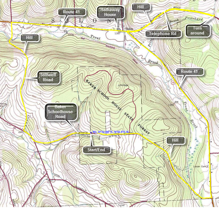 The Finger Lakes Trail is a primitive footpath that starts in Allegheny State Park on the New York - Pennsylvania border and extends 576.5 miles to end in the Catskill Park at the beginning of the Table Peekamoose Trail off the Phoenicia East Branch Trail near the Denning trailhead. There are other side trails which increase the length of the trail system. Four hundred miles of this trail is also part of the Scenic North Country Trail. The Finer Lakes Trail Conference celebrated its 50th Anniversary on June 2, 2012. To commemorate the occasion the Conference set up a series of hikes that would cover the entire length of the trail. Hikes varied in length and difficulty from 4 to 14 miles. The Trail Conference continues to improve the trails and to move sections from roads to trails.
This hike is best done with a car spot since it is 6.24 miles one way for a total of 12.8 miles. The route described here is loop and is all road walking! Take Route 26 north from Whitney Point. When Route 41 splits off from Route 26 follow it north and west for about 4.8 miles. Watch for Baker Schoolhouse road on the left. Turn left and drive about .2 miles east to where the Finger Lakes Trail crosses the road. Turn around and park on the south shoulder of the road. The trail through the forest is closed after one mile so head east on Baker Schoolhouse Road toward Route 41. The road is a back road but there can be quite a bit of traffic. The first .8 miles are slightly uphill while the final 1.5 miles is downhill. Turn left on Route 41 and headed north on the wide shoulders. The next 3 miles are almost flat and the road is very straight. At 5.2 miles you will be at the junction of Route 41 and Telephone Road near Solon. Turn right onto Telephone Road and walk uphill for about .7 miles where the road levels and then starts to go downhill a little. For the next .8 miles the road descends to the point where the trail enters the woods. If you have a car parked here, your work is done. If you have only one car, turn around to start back. At the intersection continue straight ahead through Solon on Route 41 to start a loop rather than a simple out and back. In Solon you will pass by the Hathaway House which was built in 1844 by Major-General Samuel Gilbert Hathaway, the manor house was the hub of his eight thousand acre estate as well as his political career. The mansion looks as it did for more than 150 years. The General built well with walls of stone 2 feet thick. Today it is a catering house. From the intersection it is another 1.8 miles along straight and flat Route 41 to Stillwell Road. Make a left and immediately start another climb which lasts for about .6 miles until the road levels and then starts to descend to the intersection with the McGraw Marathon Road. Make a left and hike only about a quarter mile before turning left again on Baker Schoolhouse Road. Hike a little more than a mile uphill back to the car.
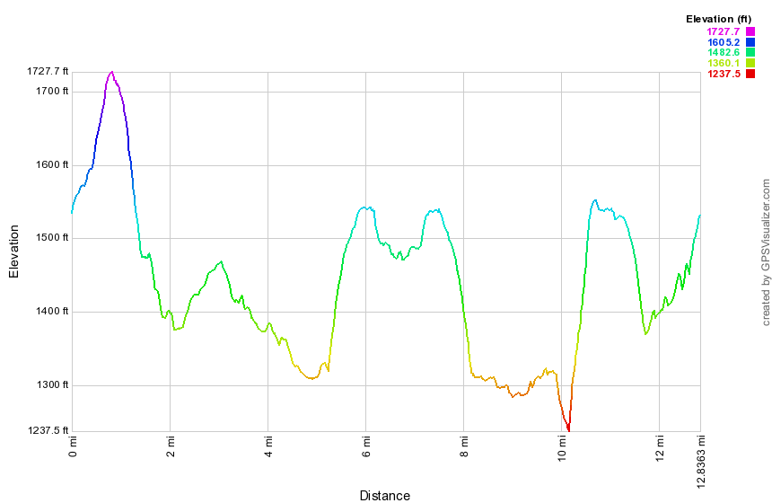 (The image at the left shows the profile of the hike. Remember that all vertical profiles are relative!)
Finger Lakes Trail: Telephone Rd to Solon Pond Rd
| Quick Look | ||||
|---|---|---|---|---|
| Difficulty | Round trip | Total climb | Internet Maps | |
| 16.0 mi. | 2772 ft. | AllTrails | ||
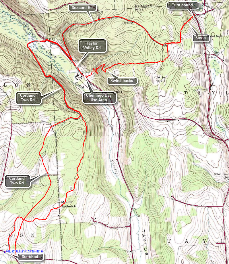 The Finger Lakes Trail is a primitive footpath that starts in Allegheny State Park on the New York - Pennsylvania border and extends 576.5 miles to end in the Catskill Park at the beginning of the Table Peekamoose Trail off the Phoenicia East Branch Trail near the Denning trailhead. There are other side trails which increase the length of the trail system. Four hundred miles of this trail is also part of the Scenic North Country Trail. The Finer Lakes Trail Conference celebrated its 50th Anniversary on June 2, 2012. To commemorate the occasion the Conference set up a series of hikes that would cover the entire length of the trail. Hikes varied in length and difficulty from 4 to 14 miles. The Trail Conference continues to improve the trails and to move sections from roads to trails.
This hike is best done as a car spot as it is at least 7.8 miles one way! The route described here is out and back using back roads on the "back" to add some variety Take I81 north from Binghamton and get off at exit 10. Head east on Route 41 for about 6 miles. As Route 41 curves to the south, continue straight ahead on Telephone Road and drive 1.3 miles to a large parking area on the right. Park in the lot then cross the road and turn right. A few hundred feet up the road we turn left or north and into the woods to start the hike. The trail starts to ascend right from the beginning and by the time you cross the Cortland Two Road it has gained over 200 feet. The Cortland Two is a dirt and gravel road that connects Telephone Road to Taylor Valley Road and runs almost 5 miles between them. Cross the road and begin to ascend Mount Roderick. At 1.4 miles you will pass by the summit after gaining another 200 feet. The trail is usually well maintained as you pass through Taylor Valley State Forest. After the summit of Mount Roderick the trail drops a little and skirts another hill. At 3 miles the trail meets the Cortland Two Road and begins a long descent. The map description warns that high water might make Cheningo Creek difficult to cross so you may want to stay on the Cortland Two until you get to Taylor Valley Road. The walk down Cortland Two is 1.7 miles. Along the way the trail cuts off to the right and crosses Cheningo Creek on some large stepping stones. The trail is definitely the shorter way to go. Near the end of the descent on Cortland Two Road the road turns from north to east and crosses Cheningo Creek and a very marshy area associated with it. At the Taylor Valley Road turn right and hike .8 miles on the shoulder to the Cheningo Day Use Area. As you enter the day use area head to the right side and look for a woods road-hog will have white blazes. This was the only place you might have a problem with the blazes! Followed the road for a short distance before the trail turns right and heads up Allen Hill. Over the next .6 miles you will climb through several switchbacks that turn a 20+ % grade into 12%. The trail begins to level at the top of a hill. Over the next .7 miles it continues to gain elevation to the west shoulder of Allen Hill whose highest point is on private land. Begin a descent and you will soon come to a woods road where you should turn right to continue a long descent to Solon Pond Road. Over the next .9 miles the trail loses over 500 feet! Once you arrive at the road in the vicinity of Freeman Road you can get in the car you have parked there or turn around to hike back to your car on Telephone Road. Climb to the junction of the woods road and the trail. Instead of turning left to continue on the trail, go straight ahead to meet Seacord Road and turn right. Walk 2.2 miles down Seacord Road to Taylor Valley Road dropping over 700 feet of elevation. Turn right on Taylor Valley Road and hike back to the Cortland TWO on the left. At 13.25 miles you will be in the area where the trail leaves the Cortland Two to the left. Continue straight on the road back to the car. Over the next 1.3 miles the road ascends, drops and ascends again. After the last ascent, it is all downhill for the next 1.4 miles to Telephone Road. At the road turn right and walk the .1 miles back to the car.
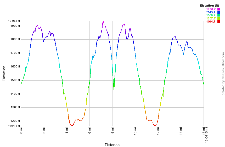 (The image at the left shows the profile of the hike. Remember that all vertical profiles are relative!)
Finger Lakes Trail: Solon Pond Rd to Stoney Brook RD
| Quick Look | ||||
|---|---|---|---|---|
| Difficulty | Round trip | Total climb | Internet Maps | |
| 12.1 mi | 1835 ft. | AllTrails | ||
 The Finger Lakes Trail is a primitive footpath that starts in Allegheny State Park on the New York - Pennsylvania border and extends 576.5 miles to end in the Catskill Park at the beginning of the Table Peekamoose Trail off the Phoenicia East Branch Trail near the Denning trailhead. There are other side trails which increase the length of the trail system. Four hundred miles of this trail is also part of the Scenic North Country Trail. The Finer Lakes Trail Conference celebrated its 50th Anniversary on June 2, 2012. To commemorate the occasion the Conference set up a series of hikes that would cover the entire length of the trail. Hikes varied in length and difficulty from 4 to 14 miles. The Trail Conference continues to improve the trails and to move sections from roads to trails.
This hike is best as a car spot since it is 7.2 miles out and 5 miles back. The route described here is a loop that uses local back roads for the return trip. Take exit 8 off I 81 at Whitney Point and follow Routes 41 and 26 north and east to Cheningo Solon Pond Rd. Drive north on the road for about 6.5 miles to Freeman Road. Park on the side of Freeman Road near the intersection. Walk down Freeman Road following the white blazes. The road curves slightly at the bottom and you should watch as the trail turns abruptly left just before an old farmhouse that is now a hunting camp. The trail goes down into a deep ditch and then passes through a sea of waist high weeds! This area can also be wet and marshy. The weeds and marshy ground don't last long and soon the trail climbs a small hill as it enters Cuyler Hill State Forest. Over the next mile the trail climbs almost 600 feet to the top of a hill and then descended to Potter Hill Road at 1.8 miles. From Potter Hill Road climb a little more and then drop to the edge of a small stream and follow it uphill until you again cross Potter Hill Road at 2.6 miles. From Potter Hill Road to Randall Hill Road the trail rolls up and down while heading north and a little west to skirt the summit of a hill. As you approach Randall Hill Road the trail descends to an unnamed brook and a bivouac area called Wiltsey Glen. There is a fire ring and a good water source. Here the trail turns west to follow the brook briefly and heads up to Randall Hill Road at 4.25 miles. An orange trail on the left goes to the Rose Hollow Bivouac Area shortly after crossing the road. At 6.2 miles you will hit the highest point on the hike as you summit 2084 foot Randall Hill. From here it is only about .5 miles to Stoney Brook Road but a series of switchbacks lengthens that to about a mile. Arrive at Stoney Brook Road after hiking 7.2 miles. If you have a car parked here, your hiking is done. If you only have one car, turn left on Stoney Brook Road and hike the short distance out tom Cuyler Hill Road where you should turn left. At 8.4 miles pass Enzes Road on the left. As you walk down Cuyler Hill Road you will be between two low ridges. It is a pretty walk and along the way there is a nice, piped spring. At 10.3 miles Randall Hill Road comes in from the left. Turn left on Cheningo Solon Pond Road at 11.4 miles and start the last part of the hike back to the car.
 (The image at the left shows the profile of the hike. Remember that all vertical profiles are relative!)
Finger Lakes Trail: Stoney Brook Rd to Paradise Hill Rd (Chippewa Falls)
| Quick Look | ||||
|---|---|---|---|---|
| Difficulty | Round trip | Total climb | Internet Maps | |
| 15.6 mi. | 2330 ft. | AllTrails | ||
 The Finger Lakes Trail is a primitive footpath that starts in Allegheny State Park on the New York - Pennsylvania border and extends 576.5 miles to end in the Catskill Park at the beginning of the Table Peekamoose Trail off the Phoenicia East Branch Trail near the Denning trailhead. There are other side trails which increase the length of the trail system. Four hundred miles of this trail is also part of the Scenic North Country Trail. The Finer Lakes Trail Conference celebrated its 50th Anniversary on June 2, 2012. To commemorate the occasion the Conference set up a series of hikes that would cover the entire length of the trail. Hikes varied in length and difficulty from 4 to 14 miles. The Trail Conference continues to improve the trails and to move sections from roads to trails.
This hike is best done as a car spot as it is 6.6 miles one way! The route described here is out and back and includes an additional 3 miles out and back to Chippewa Falls which is not part of the main Finger Lakes Trail! Take I81 north from Binghamton and get off at exit 11. Head northeast on Route 13 for 15 miles. Turn right on Lincklaen Road and drive 2 miles to Cuyler Hill Road. Turn right on Cuyler Hill Road and drive 1.5 miles to Stoney Brook Road on the left. Stoney Brook Road is dirt and gravel and is quite rough so drive carefully. Drive up the hill and passed the first parking area on the left where the forest begins. Drive a little farther to where the Finger Lakes Trail crosses and park on the shoulder of the road. To begin your hike cross the road and enter the forest. Walk to the first trail junction where an orange spur trail heads right to Chippewa Falls. Turn left to follow the Finger Lakes Trail and the Onondaga Trail back out to Stoney Brook Road at .3 miles. Turn right and walk to toward Cuyler Hill Road. At Cuyler Hill Road turn right and walk downhill for over 1.5 miles to Lincklaen Road where you should turn right. Lincklaen Road has good shoulders and a good sight lines so walking it isn't too bad. At 3.5 miles you will pass from Cortland County into Chenango County. At 3.6 miles make a left onto County Rt 12 and at 4.2 miles enter Madison County. After walking uphill slightly, look for the Finger Lakes Trail sign on the right side the of the road at 4.4 miles. Cross the road and climb a small hill on a woods road. Soon the trail turns left off the road and continues to ascend the hill through mostly hardwoods. The trail is well marked and maintained and walking is pleasant. Ahead at 5.0 miles is a stream described as "reliable" on the map. The map also mentions a bypass trail but this trail only bypasses the lean-to ahead and is really just a shortcut. The stream is nearly dry in the summer but can swell when there is heavy rain. The trail passes through evergreen trees and their needles make a nice, soft carpet for walking. At 5.2 miles you will come to the Paradise Garden Lean-to complete with fireplace and picnic table. Just before hitting a logging road at 6.1 miles, you should noticed the orange bypass trail on the left. Continue across the logging road and walk through some pines along the edge of a large field. Soon you will descend through some hardwoods to Paradise Hill Road where you can get in your second car if you have a shuttle or turn around to hike back to Stoney Brook Road. On the way back you may want to take the bypass trail which is even less used than the main Finger Lakes Trail. It is an interesting change from the main trail. It has a short but steep descent to the "reliable" stream. From the stream retrace your steps back to the road an walk back to your car at Stoney Brook Road.
At this point you are done with the main hike but you may want to visit Chippewa Falls. Be warned that the falls is all but dry in the summer and is better views in the spring or after head rains! Also be aware that the trail is not maintained and you may have to walk through high ferns and prickers and around significant blowdown. Cross Stoney Brook Road to begin the hike to the falls. Only .1 miles in you will come to the trail junction where you should continue straight ahead on the orange spur trail. The Finger Lakes Trail used to take this route until the landowner and the base of Chippewa Falls rescinded his permission to allow hiking on his land. The white blazes have been removed and replaced with the orange ones. The trail climbs a little initially but then drops over 350 feet in the last .8 miles to the falls. The trail parallels a stream for the last part of the hike and the amount of water in the stream is a clue to how much is going over the falls. When you arrive at the falls, the drop from top to bottom is truly impressive. Stay on the side you are on since the viewing is better. Do NOT descend further than the top of the falls as it is private property. Various sources list the height as being from 50 to 200 feet with the actual height being somewhere between. When you are ready, return the way you came for a total of about 3 miles.
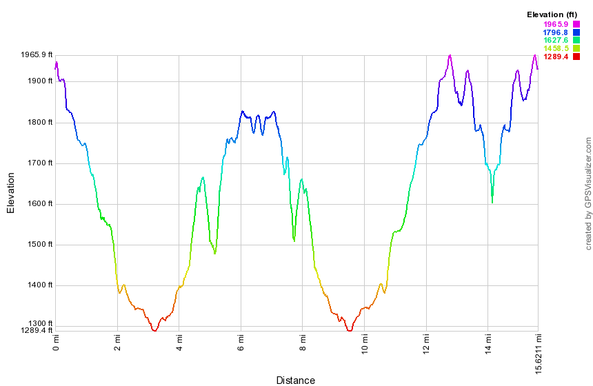 (The image at the left shows the profile of the hike. Remember that all vertical profiles are relative!)
Finger Lakes Trail: Paradise Hill to Ridge Road
| Quick Look | ||||
|---|---|---|---|---|
| Difficulty | Round trip | Total climb | Internet Maps | |
| 14.2 mi | 2170 ft. | AllTrails | ||
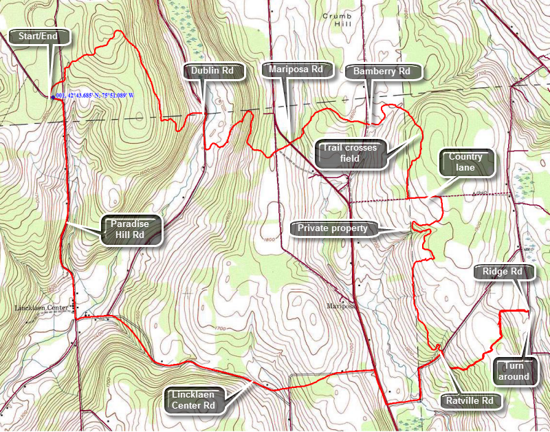 The Finger Lakes Trail is a primitive footpath that starts in Allegheny State Park on the New York - Pennsylvania border and extends 576.5 miles to end in the Catskill Park at the beginning of the Table Peekamoose Trail off the Phoenicia East Branch Trail near the Denning trailhead. There are other side trails which increase the length of the trail system. Four hundred miles of this trail is also part of the Scenic North Country Trail. The Finer Lakes Trail Conference celebrated its 50th Anniversary on June 2, 2012. To commemorate the occasion the Conference set up a series of hikes that would cover the entire length of the trail. Hikes varied in length and difficulty from 4 to 14 miles. The Trail Conference continues to improve the trails and to move sections from roads to trails.
This hike is best done with a car spot since it is 8.4 miles one way for a total of 14.2 miles. The route described here is out and back with roads use to shorten the "back" or return trip. Take the exit for Whitney Point off of I-81. Follow Route 26 north for about 21 miles northeast To Pitcher. Turn left on Route 12 and drive 8 miles through Lincklaen. Turn right on Route 12B, the Lincklaen Center Road.Drive about 2 miles and continue straight ahead on Paradise Hill Road through Lincklaen Center. Drive about 1.6 miles up the hill to just passed where Woods Road, a seasonal maintenance road heads off to the right. Park off the road on the shoulder. To begin your hike pick up the Finger Lakes Trail on the right or east side of the road. Within a few minutes you will cross Woods Road and begin ascending a Stage Coach Hill. As soon as you hit the high point you begin to descend dropping almost 600 feet to Dublin Road where you should turn right 2 miles into the hike. There is excellent parking on Dublin Road and although the surface is dirt and gravel driving it is no problem. Walk down Dublin Road for .3 miles and then turn into the woods on the left. It is only .5 miles to Mariposa Road but several switchbacks stretch this to 1 mile. Along the way you will gain over 400 feet of elevation before you cross the road. It is less than a mile from Mariposa Road to Bamberry road and the trail undulates a little along the way. At 3.5 miles you will cross a stream on a nicely built bridge. It was the only bridge across any of the streams on the hike but most of the stream are almost dry except using the wettest seasons. After crossing the bridge, head uphill on the trail. As you cross Bamberry Road the trail enters private property. In only .4 miles from the road there is a junction with the Link Trail which connects with the North Country Trail. The North Country Trail when completed will stretch from Crown Point, NY to North Dakota passing through seven states over 4600 miles! In New York the trail will follow much of the Finger Lakes Trail starting at the trail junction with the Link Trail. Just passed the Link Trail and is a sign that says "FLT to Adirondacks, Long Path, Catskills". From this point the map is relatively silent about the next two miles which is a shame since this is by far the trickiest part of the hike! Somewhere around 4.9 miles you will enter a field. The grass is often high. Look for white blazes on posts as you cross he field as there is only the hint of a trail. Head across the field and watch for white blazes on the trees on the other side. You should be turning left to follow the trail just inside the tree line. Follow these blazes through some high grass and brambles until you come to a barbed wire fence with a stile that has a white blazes. Turn left to head east along a country lane which has only a few blazes. Walk along the lane for about .2 miles as it skirts the edge of the field after which you should turn south and enter a pine forest. The next section of trail is constructed to head south while staying out of the farm fields and to do this it takes several interesting turns. A little further along the trail you will pass by the shore the of a small pond. Continue along the trail as it descends to Ratville Road 7.3 miles. There is a place to pull a car off the road here. Cross Ratville Road and hike a little over a mile to Ridge Road. The trail ascends and then descends a small hill along the way. The last part of the trail follows a nice stone wall for some distance before crossing Ridge Road at 8.4 miles where there is plenty of room to park several cars. If you have a car parked there, your hike is done. Otherwise, turn around here and head back over the hill to Ratville Road. Turn left on the dirt and gravel road and walk downhill and then slightly uphill until you get to Mariposa Road. Turn right on Mariposa Road and walk .3 miles. Turn left on Lincklaen Center Road and walk up a hill. Stay on Lincklaen Center Road for about 2.3 miles as it loses about 400 feet to the intersection with Paradise Hill Road in Lincklaen Center. Turn right on Paradise Hill Road and walk through Lincklaen Center and then start to climb Paradise Hill Road. The distance back to the car is 1.6 miles and we you will gain 460 feet.
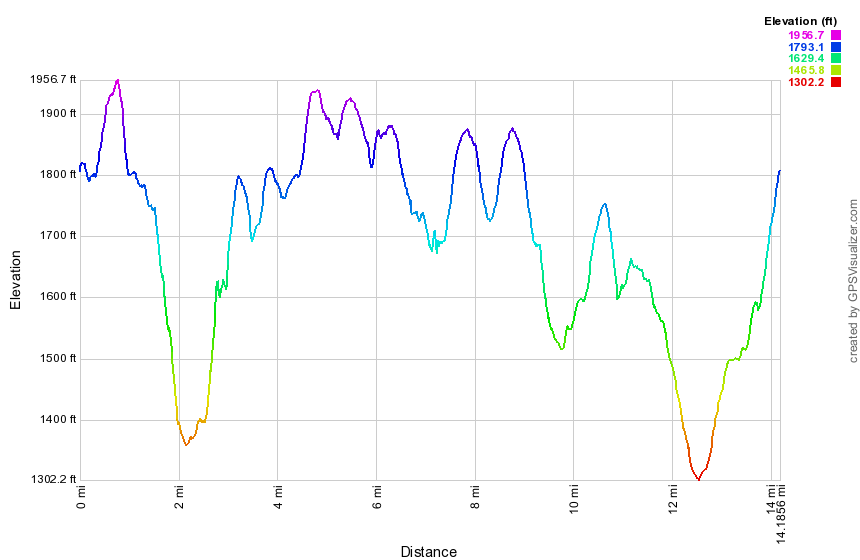 (The image at the left shows the profile of the hike. Remember that all vertical profiles are relative!)
Finger Lakes Trail: Ridge Road to Otselic SF
| Quick Look | ||||
|---|---|---|---|---|
| Difficulty | Round trip | Total climb | Internet Maps | |
| 14.6 mi | 2170 ft. | AllTrails | ||
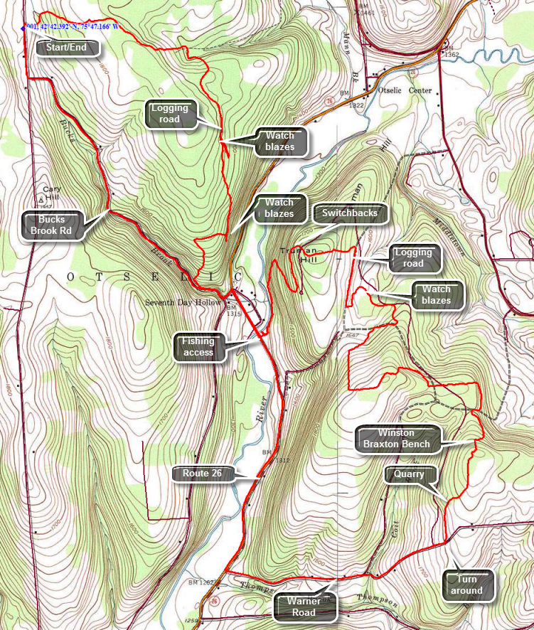 The Finger Lakes Trail is a primitive footpath that starts in Allegheny State Park on the New York - Pennsylvania border and extends 576.5 miles to end in the Catskill Park at the beginning of the Table Peekamoose Trail off the Phoenicia East Branch Trail near the Denning trailhead. There are other side trails which increase the length of the trail system. Four hundred miles of this trail is also part of the Scenic North Country Trail. The Finer Lakes Trail Conference celebrated its 50th Anniversary on June 2, 2012. To commemorate the occasion the Conference set up a series of hikes that would cover the entire length of the trail. Hikes varied in length and difficulty from 4 to 14 miles. The Trail Conference continues to improve the trails and to move sections from roads to trails.
This hike is best done with a car spot since it is 8.6 miles one way for a total of 17.2 miles. The route described here is out and back with roads used to shorten the "back" or return trip. Take the exit for Whitney Point off of I-81. Follow Route 26 north to South Otselic. Turn left on County Route 13 and then turn right on Maple St which becomes Ridge Road. After 4.25 miles on Ridge Road, you will pass Buck Brook Road and then the Finger Lakes Trail crossing about .3 miles after that.Park on the shoulder and begin your hike by entering the woods on the east side of the road. The trail almost immediately crosses a small brook and from there ascends a small hill. It drops to another stream at 1.2 miles into the hike. The trail skirts McDermott Hill on the right and begins to follow a well-defined logging road. Watch carefully since the trail veers right off the logging road at about 1.9 miles. The trail climbs a bit and then rejoins the logging road and continues to descend. Once again watch for the blazes that leave the trail to the right as the logging road starts to descend. The trail starts to ascend through the woods and then over the next .4 miles descends about 250 feet to Bucks Brook Road. Turn left at the road and walk .3 miles out to Route 26. Turn right on Route 26 and hike down the wide shoulder for .35 miles crossing the Otselic River to a fishing access on the right side. Walk through the parking area to the old road beyond. Turn left ion the road and bear slightly to the right and up a trail that parallels the river. you will have to hike up the path to find some white blaze indicating the Finger Lakes Trail. The trail follows the river but stays high on the bank for a short distance. At about 4.6 miles the trail begins a series of switchbacks to climb Truman Hill. From the river you will climb about 550 feet to the top of Truman Hill crossing a road just before the summit. After the summit the trail descends the other side of the hill to another road where the trail parallels but does not meet the road. This part of the trail can be confusing since there are so many twists and turns. At 5.6 miles turn south onto a logging road and stay on the road for about .3 miles. Turn left off the road and loop back north almost parallel to the road. Over the next 1.25 miles you will be headed north, then east, then south, then west and then south again gaining about 350 feet along the way. The trail now heads east for the next .9 miles gains and then loses elevation in the process. You will now be hiking in primarily evergreen forest. At about 8 miles you will begin another 200 foot ascent for about half a mile passing the Winston Braxton Memorial Bench along the way. You are now headed south and downhill. After passing through an old quarry you will walk through some more pines and at 9.2 miles you will be on Warner Road. If you have a car parked here, use it to return to Ridge Road. If you have only one car back at Ridge head east on Warner Road for 1.35 miles to Route 26. Along the way the road becomes paved and drops 560 feet. When you reach Route 26, turn right and head north toward the intersection with Bucks Brook Road. Route 26 has pretty good shoulders in most places but most vehicles travel quite a bit above the speed limit! You will only be on the main road for 1.8 miles. At 12 miles you will pass the fishing access area and at 12.3 miles you should turn left on Valley View Road. It is a short walk to Buck Brook Road where you turn right and head northwest along the brook. The walk up Bucks Brook Road is scenic with several small cascades that are varied and interesting, The walk up Bucks Brook Road is about 2 miles to Ridge Road and the elevation we gain is about 425 feet. At 14.3 miles at the end of Bucks Brook Road, turn right on Ridge Road and walked the final .3 miles back to the car.
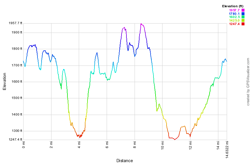 (The image at the left shows the profile of the hike. Remember that all vertical profiles are relative!)
Finger Lakes Trail: Otselic SF to John Smith Road
| Quick Look | ||||
|---|---|---|---|---|
| Difficulty | Round trip | Total climb | Internet Maps | |
| 9.1 mi | 1558 ft. | AllTrails | ||
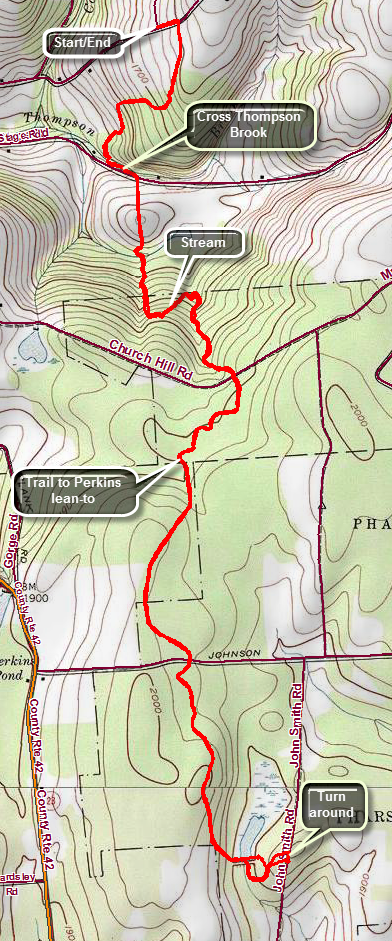 The Finger Lakes Trail is a primitive footpath that starts in Allegheny State Park on the New York - Pennsylvania border and extends 576.5 miles to end in the Catskill Park at the beginning of the Table Peekamoose Trail off the Phoenicia East Branch Trail near the Denning trailhead. There are other side trails which increase the length of the trail system. Four hundred miles of this trail is also part of the Scenic North Country Trail. The Finer Lakes Trail Conference celebrated its 50th Anniversary on June 2, 2012. To commemorate the occasion the Conference set up a series of hikes that would cover the entire length of the trail. Hikes varied in length and difficulty from 4 to 14 miles. The Trail Conference continues to improve the trails and to move sections from roads to trails.
This hike can be done with a car spot but it is only 9.1 miles round trip. The route described here is out and back with a little variation thrown in! Take the exit for Whitney Point off of I-81. Follow Route 26 north for about 29 miles passing through South Otselic. Watch for Stage Road on your right shortly after passing through town. Drive to the end of the road and turn left on Will Warner Road. The road is dirt and gravel and not maintained during the winter after a certain point. Drive 1 mile on Warner Road and you will find an access road to Otselic SF on the right. Park at the end of the road at the intersection out of the way of "traffic". Begin your hike by walking east on Warner Road for about .1 miles. Turn right into the forest and almost immediately run into some wet spots on the trail. Over the next .7 miles the trail drops over 300 feet to Thompson Brook before ascending slightly to meet Stage Road. You will have to walk back up this hill at the end of you hike if you do not have a car shuttle. As we were losing elevation I thought about the return trip knowing that I would be tired. I stopped at Thompson Brook to take a few pictures before walking up to Stage Road. Once on Stage Road we turn left and walk a few hundred feet up the road to where the trail crosses the ditch and heads into a field. Hug the left edge of the field but do not be surprised if you find only one or two blazes. Over the next 1.1 miles the trail continues to ascend but dips several times to cross streams. Most of the streams do not have bridges and several crossing could be tricky in highwater. Watch for small waterfalls along the way during periods of high water.Crossed Church Road at about 2 miles at which point the trail levels some and the surface becomes more even. Pass a trail register and then at around 2.5 miles we pass a blue blazed trail on the right to the Perkins Pond Lean-to. The trail to the lean-to is .4 miles. At 3.3 miles cross Johnson Street. The trail has gained a little elevation and you will be hiking at about 2040 feet before descending to the dam at the south end of Jackson Pond. Walk to the spillway, turn right and descend through a small field or clearing to pick up the blazes of the Finger Lakes Trail. Follow the blazes as they cross the access road and lead you to John Smith Road. Turn around a retrace your route back to the car.
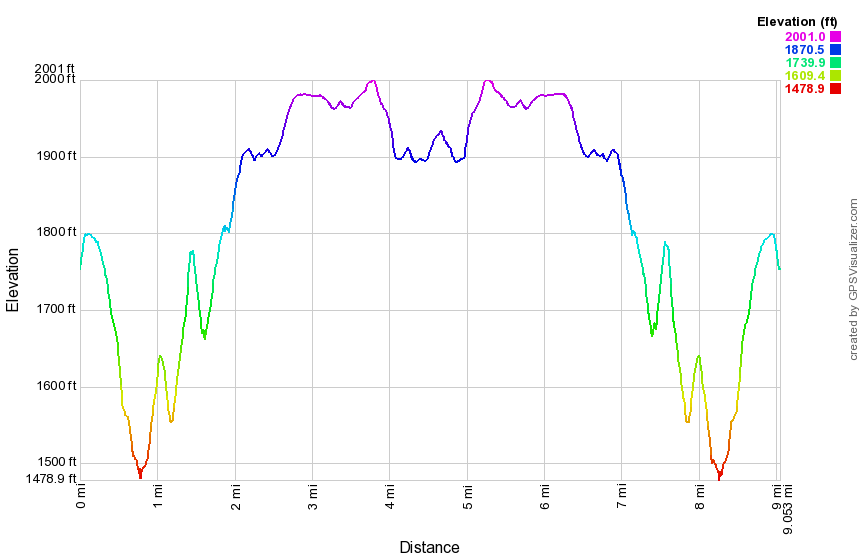 (The image at the left shows the profile of the hike. Remember that all vertical profiles are relative!)
Finger Lakes Trail: John Smith Rd to Fred Stewart Rd
| Quick Look | ||||
|---|---|---|---|---|
| Difficulty | Round trip | Total climb | Internet Maps | |
| 11.3 mi | 1030 ft. | AllTrails | ||
 The Finger Lakes Trail is a primitive footpath that starts in Allegheny State Park on the New York - Pennsylvania border and extends 576.5 miles to end in the Catskill Park at the beginning of the Table Peekamoose Trail off the Phoenicia East Branch Trail near the Denning trailhead. There are other side trails which increase the length of the trail system. Four hundred miles of this trail is also part of the Scenic North Country Trail. The Finer Lakes Trail Conference celebrated its 50th Anniversary on June 2, 2012. To commemorate the occasion the Conference set up a series of hikes that would cover the entire length of the trail. Hikes varied in length and difficulty from 4 to 14 miles. The Trail Conference continues to improve the trails and to move sections from roads to trails.
This hike is best done with a car spot since it is 7.1 miles one way for a total of 11.3 miles. The route described uses the Finger Lakes Trail on the way "out" and local roads on the way "back" shortening the trip from 14.2 miles to 11.3 miles. Most of the roads are lightly traveled gravel roads except for a short (.6 mile) strip of Route 23. This hike travels over sections of the trail that were rerouted in the spring and summer of 2016. They replace some sections of the section before and after this hike. Take County Route 23 west from Norwich for about 13.5 miles toward North Pharsalia. Watch for John Smith Road on the right just after Elmer Jackson Road. Drive up John Smith Road for about .8 miles watching for a pulloff on the right for Jackson Pond. Park in the small parking area. Begin your hike my walking north on the road just slight until the Finger Lakes Trail crosses and turn right into the woods. The first mile is downhill and is the same as the previous route. At .8 miles you will pass by the remains of the old CCC camp. Some of the stone and concrete foundations are still in place. At 1.0 miles the trail meets Elmer Jackson Road. Turn right or south to follow the road to Lower Pond. There is a small dam at the outlet and exploring downstream of the dam yields some nice pictures. At this point the old route passed across the dam and headed out to Grover Brown Road. The new route continues farther down Elmer Jackson Road. Walk down the road about .6 miles and watch for the Finger Lakes Trail as it turns into the woods on the left just after the road swings to the right. The trail travels through the woods for only .4 miles when it again comes out to the road and follows it south for .1 miles until entering the woods on the right side of the road. The trail heads east and then turns south descending now toward Route 23. At the end of the descent, just before Route 23 are two bridges across Canasawacta Creek. The first is a simple flat bridge without railings. The second, spanning the main creek, is a beautiful kingpost bridge. Cross the bridges and follow the trail up to Route 23. After crossing the road, the trail climbs steeply up the bank but it doesn't last very long and soon levels out and rolls some. This is still the new reroute of the trail which avoids the road walk on Grover Brown Road and Route 23. The trail continues south over the top of a hill and down the other side crossing gravel covered Center Road at 3.8 miles. At 4.1 miles it turns east and then south again at 4.8 miles near a bivouac area. The old trail is marked in blue here and heads to the bivouac. Continue on the trail which is now the same as the old trail to Nine Mile DEC Truck Trail at 5.7 miles. Turn left and follow the road briefly before following the trail as it turns into the woods on the right. Continue to walk south and slightly downhill to 6.2 miles where the trial turns east. Much of the trail is what I call "roots, rocks, trees" and, while pretty, has no real remarkable features. The trail turns south again at 6.7 miles and you should watch for the Ed Sidote, Mr. FLT, bench on the left. This is also the point where a spur trail leads west to the Pharslia Woods Lean-to. Continue on the main trail east to Fred Stewart Road. Your trail hiking is now complete and you are ready for the return trip to the car using local roads. Turn left on Fred Stewart Road to head north. After a short distance, turn left on the DEC Road heading northwest toward North Road. Walk passed the area where you crossed the road earlier and at 8.8 miles arrive at North Road. Turn right to head north toward Route 23. At 9.3 miles cross Center Road and hit the paved part of North Road. From here descend for .5 miles to Route 23. Turn left and walked west for .4 miles on Route 23. Turn right and start the final .8 mile hike up John Smith Road to the car. Once at the car you may want to take the access trail down to Jackson Pond. The Finger Lakes Trail cuts below the dam but stay on the access trail to the dam to get a better look at the pond. When you are done, retrace your steps to the car.
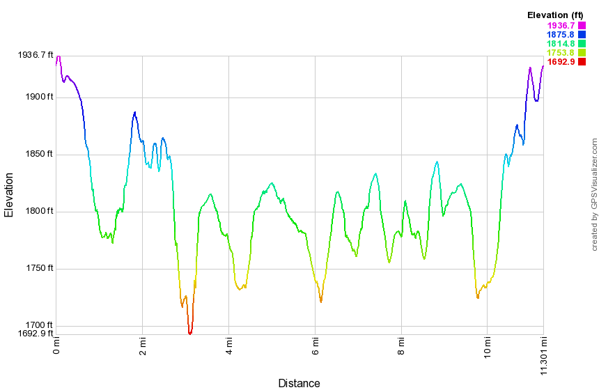 (The image at the left shows the profile of the hike. Remember that all vertical profiles are relative!)
Finger Lakes Trail: Fred Stewart Rd to Berry Hill
| Quick Look | ||||
|---|---|---|---|---|
| Difficulty | Round trip | Total climb | Internet Maps | |
| 5.3 mi | 675 ft. | AllTrails | ||
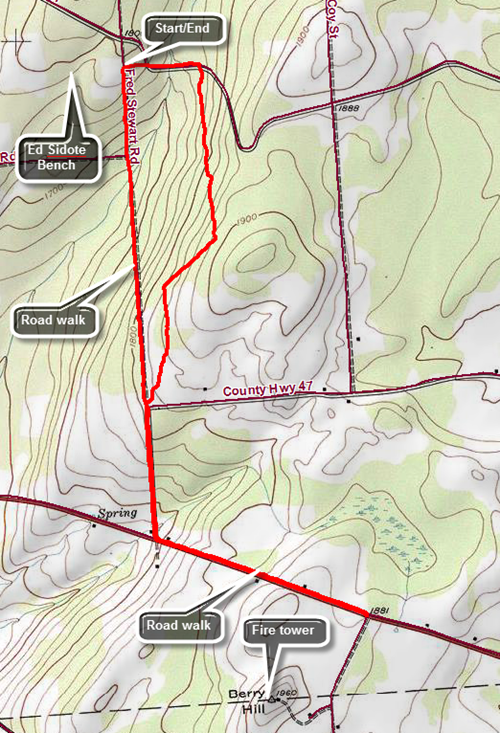 The Finger Lakes Trail is a primitive footpath that starts in Allegheny State Park on the New York - Pennsylvania border and extends 576.5 miles to end in the Catskill Park at the beginning of the Table Peekamoose Trail off the Phoenicia East Branch Trail near the Denning trailhead. There are other side trails which increase the length of the trail system. Four hundred miles of this trail is also part of the Scenic North Country Trail. The Finer Lakes Trail Conference celebrated its 50th Anniversary on June 2, 2012. To commemorate the occasion the Conference set up a series of hikes that would cover the entire length of the trail. Hikes varied in length and difficulty from 4 to 14 miles. The Trail Conference continues to improve the trails and to move sections from roads to trails.
Take County Route 23 west from Norwich for about 11.8 miles toward North Pharsalia. Watch for Fred Stewart Road on the left. Drive south on Fred Stewart Road for 2.1 miles and park off the side of the road where the Finger Lakes Trail crosses the road. Head east on the Finger Lakes Trail going downhill to the CCC road where you will turn right. After .3 miles on the road, the trail again enters the woods on the right. Over the next 1.3 miles the trail ascends and descends a small hill staying parallel to the road until meeting it again at the intersection with Hoag-Childs Road. At this point the rest of the hike is a road walk to North Tower Road. Fred Stewart Road is now paved and the walk is downhill for .5 miles to Route 10. You will pass Dave Markham's machine shop where water is available. At Route 10 turn left and start to walk east to North Tower Road. Route 10 is busy and has no paved shoulders for walking. It does have good sight lines so that you can get out of the way when cars or trucks are coming. The walk is mostly up hill for .8 miles to the intersection with Tower Road. Walking south on Tower Road for .3 miles allows you to visit the Berry Hill fire tower. Turn around and retrace your route back to your car. To save some distance, you can hike back all the way on Fred Stewart Road. The walk is pleasant as the road is mostly dirt and gravel and is very lightly traveled. Hike back on Route 10 to the intersection with Fred Stewart Road. Turn right and hike 1.7 miles back to your car.
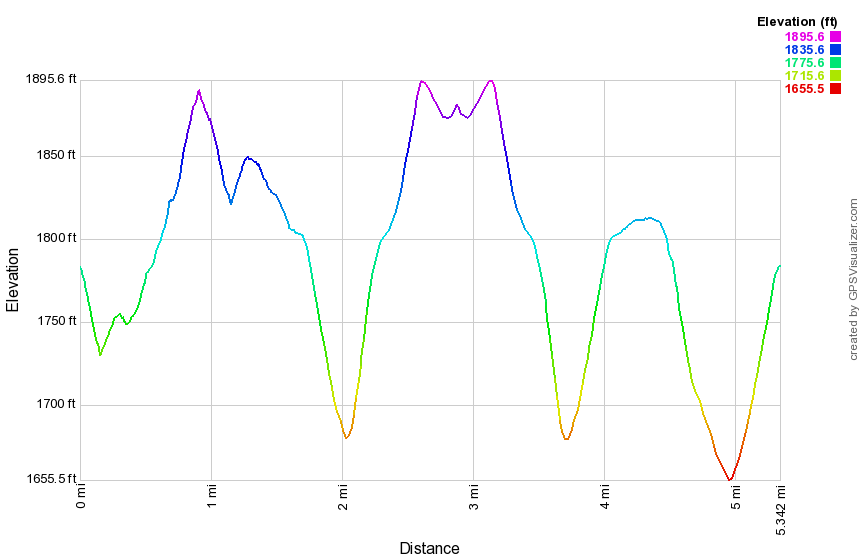 (The image at the left shows the profile of the hike. Remember that all vertical profiles are relative!)
Finger Lakes Trail: Berry Hill to East McDonough
| Quick Look | ||||
|---|---|---|---|---|
| Difficulty | Round trip | Total climb | Internet Maps | |
| 12.0 mi | 1220ft. | AllTrails | ||
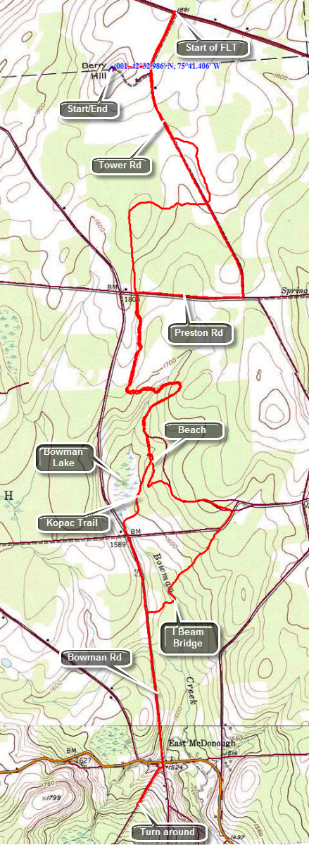 The Finger Lakes Trail is a primitive footpath that starts in Allegheny State Park on the New York - Pennsylvania border and extends 576.5 miles to end in the Catskill Park at the beginning of the Table Peekamoose Trail off the Phoenicia East Branch Trail near the Denning trailhead. There are other side trails which increase the length of the trail system. Four hundred miles of this trail is also part of the Scenic North Country Trail. The Finer Lakes Trail Conference celebrated its 50th Anniversary on June 2, 2012. To commemorate the occasion the Conference set up a series of hikes that would cover the entire length of the trail. Hikes varied in length and difficulty from 4 to 14 miles. The Trail Conference continues to improve the trails and to move sections from roads to trails.
This hike is best done with a car spot since it is 6 miles one way for a total of 12.0 miles. The route described here is out and back with a little variation thrown in! Take County Route 10A west from Norwich for 5.0 miles. Continue on County Road 10 for another 3.5 miles. Turn left on Tower Rd and drive .3 miles to the access road for Berry Hill Fire Tower on the right. Turn right on the access road and park in the small lot near the tower. The tower is being used for law enforcement radio communications and is off limits to the public. You can climb the tower to the locked gate to get a slightly better view of the surrounding countryside. To begin your hike walk down the access road to Tower Road. Turn left and hike out to Route 10 where this section of the Finger Lakes Trail actually begins. At Route 10 turn around and hike back to the access road, passing it and continuing south on Tower Road. Walk about .75 miles to the point where the trail enters the forest. Walk through a stand of tall pines. At 1.2 miles cross Tower Road and head west briefly before turning south and crossing Preston Road at around 2.1 miles. The trail rolls a little but is mostly downhill at you walk south. Over the next 1.4 miles the trail makes several twists and turns but generally heads south and downhill. The trail seems to follow an old road and only leaves that road when it is blocked by blowdowns. There are some interesting rock formations along the way and a set of small bridges over some wet areas. There is also a larger bridge over a stream. All of these may be slippery when wet! At 3.5 miles you will arrive at one of the parking areas at Bowman Lake State Park. The trail heads down to the beach area. The park has a small but beautiful lake with a nice beach and a roped swimming area. Walk behind some buildings on the trail and follow the blazes until you are on the park road. Turn right on the road and walk to the next intersection and turn left to pass by the Nature Center. The trail actually follows the shoreline behind the concession stand and then comes up to the road. This route seems abandoned as if most people simply followed the road. Continue to follow the blazes on the road and you will eventually pass the park entrance and come to Sherman Road at 4.2 miles where you turn right. Walk about .1 miles down the road and turn left into the woods. The trail heads southwest for about .7 miles and along the way crosses Bowman Creek on a bridge made from a steel I beam. The I beam was laid on its side and spans the creek with a handrail on one side. Walk out to Bowman Road which goes south for about .8 miles and ends at Route 220 in East McDonough. Cross the road and walk through an opening in a chain link fence to cross a playground. On the other side is a woods road that begins a climb to a trail register at 6.0 miles. Turn around and go back to Bowman Road and do not turn onto the trail. Just passed the turn is a small, rural cemetery which is very old. Explore the Gale Cemetery if you wish. At the end of the road cross over and enter a path on the other side. The path brings you to the south shore of Bowman Lake. Continue along the shore of the lake and pick up the blue blazes of the Kopac Trich which runs around the lake. Continue to follow the blue blazes until they meet the white blazes of the Finger Lakes Trail behind the concession stand. Follow them back passed the beach and to the parking area where the trail enters the woods. Hike the trail to Preston Road and turn right on the road to Tower Road. Turn left on Tower Road. Walk the last 1.3 miles on Tower Road to the access road to the tower. Turn left and walk back up the hill to your car.
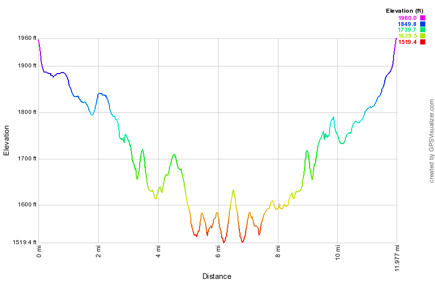 (The image at the left shows the profile of the hike. Remember that all vertical profiles are relative!)
Finger Lakes Trail: McDonough to Stone Quarry Hill Road
| Quick Look | ||||
|---|---|---|---|---|
| Difficulty | Round trip | Total climb | Internet Maps | |
| 12.6 mi | 1200 ft. | AllTrails | ||
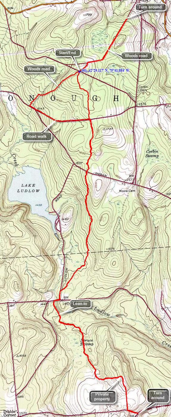 The Finger Lakes Trail is a primitive footpath that starts in Allegheny State Park on the New York - Pennsylvania border and extends 576.5 miles to end in the Catskill Park at the beginning of the Table Peekamoose Trail off the Phoenicia East Branch Trail near the Denning trailhead. There are other side trails which increase the length of the trail system. Four hundred miles of this trail is also part of the Scenic North Country Trail. The Finer Lakes Trail Conference celebrated its 50th Anniversary on June 2, 2012. To commemorate the occasion the Conference set up a series of hikes that would cover the entire length of the trail. Hikes varied in length and difficulty from 4 to 14 miles. The Trail Conference continues to improve the trails and to move sections from roads to trails.
This hike is best done with a car spot since it is 6.3 miles one way for a total of 12.0 miles. The route described here is out and back with a little variation thrown in! Take Route 220 west from Oxford for 4.0 miles. Turn left onto Chestnut Road and drive for 1.4 miles to Corbin Road. Turn right on Corbin Road and then immediately left on Shortcut Road. Shortcut Road is mostly packed dirt with large cobbles. It is one car wide with deep ditches on both sides. You must drive about .7 miles to the small parking area and there area only a few pulloffs along the way. If you can't backup for some distance or feel the road is too rough an alternative is to park on Chestnut Road where the Finger Lakes Trail crosses and hike from there. At about .7 miles on Shortcut Road there is a woods road that crosses the road and signs for the Finger Lakes Trail. There is enough room to pull off the road and park one or two cars. When you are ready to hike, start north on the woods road toward the trail register in East McDonough. The road may be muddy in places with some ruts but this should only last for about .15 miles. The road is straight and hard packed after that and in about .9 miles you will be at the trail register where you can turn around and head back to the car. At the car cross the road and make a choice. The trail heads off into the woods on the left and a snowmobile trail goes straight ahead. The trail is shorter but the snowmobile trail offers some variety so that you will not be hiking the identical path on the way back. Stay on the woods road which is also a snowmobile trail and walk for .8 miles until you hit Chestnut Road. Turn left and head east on Chestnut Road for .7 miles where the Finger Lakes Trail crosses Chestnut Road. Turn south onto the Finger Lakes Trail and walk 2.2 miles to Ludlow Road. The trail seems little used and many blazes are faded. In several spots there are large blowdowns across the trail. Some had been there a long time and the trail is blazed around them. In other places you will have to work your way around the blockages and then try to find the trail on the other side. When you get to Ludlow Road turn left and follow it to Tucker Road. Turn right and cross the creek on the bridge. Just after the bridge, the trail turns left into the woods and follows a woods road. It is only a short distance to the blue blazed side trail on the left to the Ludlow Creek lean-to. The next landmark is a pile of rocks right on the trail. The map description mentions that the pile is of unknown origin with a suggestion of a Native American burial! The trail enters private land and the road becomes grassy and very marshy in places. When you get to an open field walk along the edge of the field outside a barbed wire fence. Within minutes you will pass by some buildings near Stone Quarry Hill Road with the road just beyond. Walk down to County Route 3 to the end of the trail section. Turn around and walk back to where the trail enters the field. Retrace your route back to where the Finger Lakes Trail crosses Chestnut Road. Cross the road and continue straight ahead on the trail. The trail passes through some conifers and then hardwoods. It is a much more direct than the route you took earlier and is only about .6 miles back to the car.
 (The image at the left shows the profile of the hike. Remember that all vertical profiles are relative!)
Finger Lakes Trail: Stone Quarry Hill Rd to South Oxford Bridge
| Quick Look | ||||
|---|---|---|---|---|
| Difficulty | Round trip | Total climb | Internet Maps | |
| 10.6 mi. | 1650 ft. | AllTrails | ||
 The Finger Lakes Trail is a primitive footpath that starts in Allegheny State Park on the New York - Pennsylvania border and extends 576.5 miles to end in the Catskill Park at the beginning of the Table Peekamoose Trail off the Phoenicia East Branch Trail near the Denning trailhead. There are other side trails which increase the length of the trail system. Four hundred miles of this trail is also part of the Scenic North Country Trail. The Finer Lakes Trail Conference celebrated its 50th Anniversary on June 2, 2012. To commemorate the occasion the Conference set up a series of hikes that would cover the entire length of the trail. Hikes varied in length and difficulty from 4 to 14 miles. The Trail Conference continues to improve the trails and to move sections from roads to trails.
This hike is best done as a car spot as it is 5.3 miles one way! The route described here is out and back! Take Route 12 south from Oxford. In 1.8 miles turn right on Route 3 heading west. After 3 miles, watch for Stone Quarry Hill Road on the right. Turn on the road and drive a few hundred feet to a log house on the right. Park on the grass just before the house next to the FLT sign. Walk down the road to Route 3 and turn right and then immediately left on Fred Wilcox Road. The road rolls a little as it passes some houses and a farm. At 1.3 miles continue on the road as it bends to the left and turns into French Road. Walk .2 miles more to the beginning of the trail through the forest on the right which is clearly marked. The trail climbs a little over a small hill and then starts to descend. The woods were mostly hardwoods and some areas may be wet. The trail here seems used by hikers and horses alike! Over the next 1.9 miles you will drop about 500 feet in elevation eventually hitting a woods road and then skirting the edge of a field to end up at Buckley Corners. At the corners the trail is clearly visible on the other side of the road. Cross the road and you will quickly come to one of several stiles on the trail. These stiles are triangular frames with crosspieces that straddled the fences. They allow you to climb up and over the fence. In most cases the fences are in disrepair and the stiles are superfluous but they add an interesting touch. The trail now parallels Bowman Creek and you can hear, and sometimes see, the water below. For the next 1.7 miles the trail runs along the creek and, in general, descended as you head toward Route 12. In several spots you may gain a little elevation and then drop it again as the trail avoids deep drops into some small ravines. Near the end of the trail there is a sign that described a sawmill that existed on the creek in 1875. You may be able to spot the foundations down near the stream bed. Cross another stile and then walk along the edge of a field to a short trail that leads down to Route 12. Turn left and walk a few hundred feet to South Oxford Bridge Road where you should turn right. It is a short walk to the bridge over the Chenango River. Just before the river are faint remnants of the Chemung Canal in a cornfield. On the other side of the bridge ware some abandoned Conrail tracks and a small parking area. If you parked a car here you are done with your hike. If your car is at Stone Quarry Hill Road, turn around an retrace your rote. As you return along Bowman Creek there is a path that leads down to the stream but the bank is very steep. This is about 3.6 miles from the beginning of the trail or 6.7 miles on the return trip. The falls is very nice even in low water. The stream is shallow in most places but there is a deep pool. Back on the main trail walk back out to Buckley Corners. Walk back along the edge of the field and then start a long but gradual 1.5 mile climb regaining the 500 feet you lost earlier in the hike. At 8.9 miles you will hit the high point on the trail and then descend to French Road where you turn left to begin the road walk back to the car.
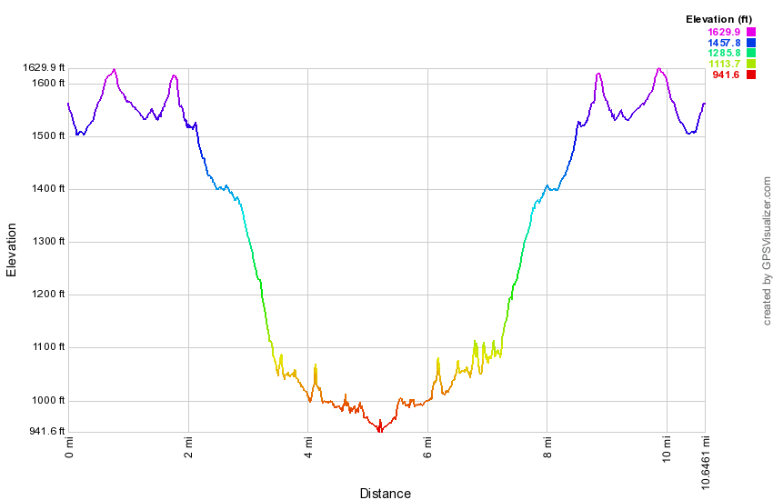 (The image at the left shows the profile of the hike. Remember that all vertical profiles are relative!)
Finger Lakes Trail: South Oxford Bridge to Basswood Rd
| Quick Look | ||||
|---|---|---|---|---|
| Difficulty | Round trip | Total climb | Internet Maps | |
| 6.8 mi | 700 ft. | AllTrails | ||
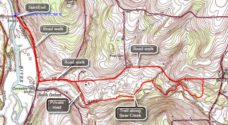 The Finger Lakes Trail is a primitive footpath that starts in Allegheny State Park on the New York - Pennsylvania border and extends 576.5 miles to end in the Catskill Park at the beginning of the Table Peekamoose Trail off the Phoenicia East Branch Trail near the Denning trailhead. There are other side trails which increase the length of the trail system. Four hundred miles of this trail is also part of the Scenic North Country Trail. The Finer Lakes Trail Conference celebrated its 50th Anniversary on June 2, 2012. To commemorate the occasion the Conference set up a series of hikes that would cover the entire length of the trail. Hikes varied in length and difficulty from 4 to 14 miles. The Trail Conference continues to improve the trails and to move sections from roads to trails.
This hike can be done as a car spot but it is only 6.8 miles. The route described here is out and back with a little loop thrown in! Take Route 12 south from Oxford for about 4 miles. Watch for South Oxford Bridge Road on the left. Turn left on the road and drive across the bridge over the Chenango River. Park in the small pullout on the left side of the road before the railroad tracks. The white blazes of the Finger Lakes Trail lead Southbridge Road up to Route 32. Turn right on Route 32 and walk south for .7 miles. Turn left on Basswood Road.and walk slightly uphill for .4 miles. Turn right onto a private woods road and walk through a gate on the The trail description on the Finger Lakes Trail Conference maps is a little unclear from this point on but the blazes are very clear. The trail winds its way down to Bear Creek and then begins to parallel the stream. The description on the map mentions waterfalls but there are NO WATERFALLS. There are a few areas where some water drops one or at the most two feet over some rocks with some deeper pools. At about 3.4 miles the trail begins to pull away from the creek and starts uphill towards Basswood Road. This part of the trail can get very overgrown with brush and weeds. Sometimes you may have to hack through milkweed and goldenrod just to make a path. In other areas, there may only be a low "tunnel" through the bushes. Soon you will briefly enter a stand of conifers near the trail register and just before entering the field that takes you up to Basswood Road. Once you hike up to the road you may turn around and reverse your hike through the woods. You may also turn left on Basswood Road and hike back to where you turned onto the private road. It is easier walking and saves a little less than a mile. For 1.7 miles you will walk mostly downhill on the road until you are at the private woods road. From this point is was about .4 miles back to Route 32 and then 1.1 miles back to the car.
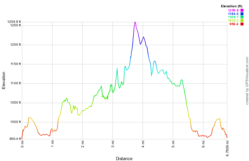 (The image at the left shows the profile of the hike. Remember that all vertical profiles are relative!)
Finger Lakes Trail: Basswood Rd to Cooper Schoolhouse Rd
| Quick Look | ||||
|---|---|---|---|---|
| Difficulty | Round trip | Total climb | Internet Maps | |
| 11.9 mi | 1450 ft. | AllTrails | ||
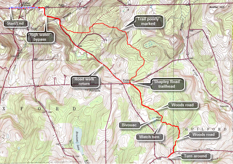 The Finger Lakes Trail is a primitive footpath that starts in Allegheny State Park on the New York - Pennsylvania border and extends 576.5 miles to end in the Catskill Park at the beginning of the Table Peekamoose Trail off the Phoenicia East Branch Trail near the Denning trailhead. There are other side trails which increase the length of the trail system. Four hundred miles of this trail is also part of the Scenic North Country Trail. The Finer Lakes Trail Conference celebrated its 50th Anniversary on June 2, 2012. To commemorate the occasion the Conference set up a series of hikes that would cover the entire length of the trail. Hikes varied in length and difficulty from 4 to 14 miles. The Trail Conference continues to improve the trails and to move sections from roads to trails.
This hike is best done with a car spot since it is almost 6 miles one way for a total of 11.9 miles. The route described here is out and back with a little variation thrown in! Take Route 41 north from Afton and continue through the intersection with Route 206 where the road designation is now Route 27. Watch for Basswood Rd on the left at about 5.5 miles from the Route 206 intersection. Turn left and drive .2 miles to where the Finger Lakes Trail meets the road. Park just east of the trailhead on the south side of the road. The first part of the hike proceeds east for about .75 miles on Basswood Rd and Brookbanks Rd to the corner of Puckerville Road. At this point you can decide to stay on the main trail or take the high water bypass as there is no bridge over the creek on the main trail. To take the bypass turn right on Puckerville Road hike about .6 miles to where the trail cut into the woods to join the main Finger Lakes Trail. For the next 2.9 miles the trail passes through mostly hardwood forest and gains about 500 feet. The trail may not be well used and the blazes are faded so as to be almost invisible in some places. There are several wet areas where old half log bridges and some corduroy are positioned to try to help. Both of these can be very slippery. In one area the trail passes near a large field where the trees are few and far between. This has allowed the prickers and the ferns to take over to make the trail virtually disappear. This combined with the lack of blazes makes following the trail very difficult. Eventually the trees return and it becomes easier to follow the trail. You will pass through some fences that have openings with boards over the top to restrict the height of what can easily pass through. At 4.25 miles you will be at Shapley Road which has a small trailhead and a kiosk for Wiley Brook State Forest. When you cross Shapley Road, you will enter Wiley Brook State Forest. The trail looks more used here and it passes through a large stand of conifers which reduces the undergrowth. Hike up a hill and the trail levels off and eventually joins a well-defined woods road. Within .5 miles from Shapley Road, there is a blue-blazed spur trail on the right which leads to a bivouac area near Mud Pond. Continue on the woods road until about 5.3 miles where the trail leaves the woods road to the left. The turn is marked butt is easy to stay on the road and miss it. If you arrive at an open field, you missed the turn! After another .65 miles on the trail, you will meet a grassy road at about 6 miles. Turn right and walk .2 miles before turning off the road and back onto a trail. The trail only last for .2 miles before meeting Cooper Schoolhouse Road. Turn right and walk .2 miles to the corner of Cooper Schoolhouse Road and the Case-Guilford Road which is also marked as Town Line Road. Turn around and retrace your route back to Shapley Road. From Shapley Road you may continue on the trail back to the car. You may also turn left on Shapley Road and walk .1 miles down to Puckerville Road. Turn right and follow Puckerville Road back to Brook Banks Road, a distance of only 2.5 miles. Turn left on Brookbanks Road and walk the remaining .7 miles back to the car. This avoids rehiking some of the least interesting parts of the trail but is best done when the sun is NOT beating down on you. This route is 6.5 miles out and 5.4 miles back.
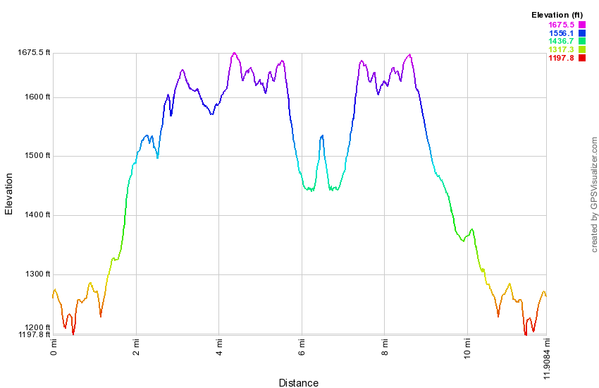 (The image at the left shows the profile of the hike. Remember that all vertical profiles are relative!)
Finger Lakes Trail: Cooper Schoolhouse Rd to Case Rd
| Quick Look | ||||
|---|---|---|---|---|
| Difficulty | Round trip | Total climb | Internet Maps | |
| 7.6 mi | 940 ft. | AllTrails | ||
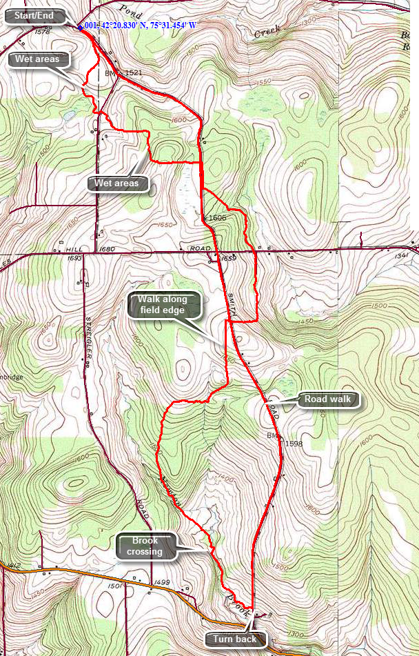 The Finger Lakes Trail is a primitive footpath that starts in Allegheny State Park on the New York - Pennsylvania border and extends 576.5 miles to end in the Catskill Park at the beginning of the Table Peekamoose Trail off the Phoenicia East Branch Trail near the Denning trailhead. There are other side trails which increase the length of the trail system. Four hundred miles of this trail is also part of the Scenic North Country Trail. The Finer Lakes Trail Conference celebrated its 50th Anniversary on June 2, 2012. To commemorate the occasion the Conference set up a series of hikes that would cover the entire length of the trail. Hikes varied in length and difficulty from 4 to 14 miles. The Trail Conference continues to improve the trails and to move sections from roads to trails.
This hike can be done with a car spot but it is only 7.6 miles round trip. The route described here is a loop using roads for the return trip! Take Route 206 west from Bainbridge and watch for Case Road on the right. Turn onto Case Road and follow it to where it crosses Searles hill Road and turns to gravel and dirt. Drive to the intersection with Town Line Road and continue straight ahead to Cooper Schoolhouse Road. Park on the corner on the right side of the road. Walk southeast on Town Line Road for about .1 miles before cutting right into the woods on the trail. The next .6 miles of trail can be wet in spots but you should be able to get around or through them without too much trouble. The next .7 miles to Case Road is about the same as you climb a small hill and then hit the road. Turn right on Case Road and follow the blazes on the road for about .15 miles until the trail again cuts into the woods on the left. Over the next .9 miles the trail drops some elevation to cross Searles Hill Road and then gains it back to again cross Case Road all the while heading generally south. There are a few places along the way where the blazes are spaced apart and a few others where the weeds can be high. After crossing Case Road again the trail skirts a field and then runs along the edge of the field and some lawns. It re-enters the woods and at about 3.4 miles starts to parallel Newton Brook. The crossing of the brook at 3.6 miles should not be a problem unless the water is VERY high. Continue to walk along the brook and at 4 miles cross it again on a bridge. The trail leads to a field and then back onto some woods roads until it again met Case Road at 4.3 miles. Turn left on Case Road and use it to get back to the car. You are at the lowest point on the hike so the first part of the walk up Case Road is uphill and you will gain almost 400 feet in 1.4 miles to the point where you last crossed. Along the way watch for the point where the trail enters the woods and heads for Bainbridge. Within .5 miles, cross Searles Hill Road where Case Road turns to gravel and dirt. The next 1.5 miles is generally downhill but rolls a little.
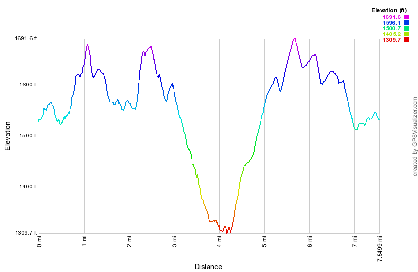 (The image at the left shows the profile of the hike. Remember that all vertical profiles are relative!)
Finger Lakes Trail: Bainbridge to Case Road
| Quick Look | ||||
|---|---|---|---|---|
| Difficulty | Round trip | Total climb | Internet Maps | |
| 5.3 mi | 925 ft. | AllTrails | ||
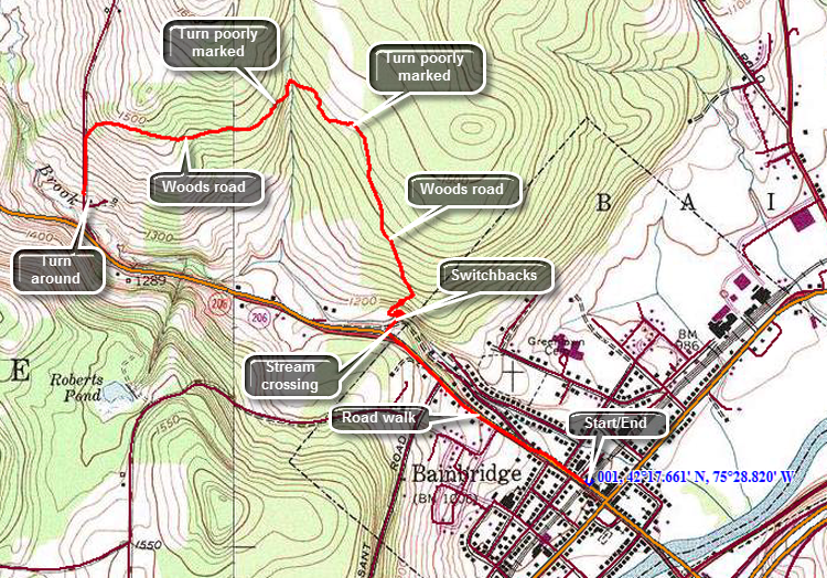 The Finger Lakes Trail is a primitive footpath that starts in Allegheny State Park on the New York - Pennsylvania border and extends 576.5 miles to end in the Catskill Park at the beginning of the Table Peekamoose Trail off the Phoenicia East Branch Trail near the Denning trailhead. There are other side trails which increase the length of the trail system. Four hundred miles of this trail is also part of the Scenic North Country Trail. The Finer Lakes Trail Conference celebrated its 50th Anniversary on June 2, 2012. To commemorate the occasion the Conference set up a series of hikes that would cover the entire length of the trail. Hikes varied in length and difficulty from 4 to 14 miles. The Trail Conference continues to improve the trails and to move sections from roads to trails.
This hike can be done with a car spot but the round trip hike is only 5.3 miles! The route described here is a an out and back! There is no parking on Case Road which is why the hike starts in Bainbridge and proceeds 'backwards". The biggest problem with this hike is that the trail is VERY poorly marked. Trying to follow the blazes can be frustrating in BOTH DIRECTIONS! Go to Bainbridge and park in the municipal parking lot near the old train station. Walk northwest on Route 206 using the village sidewalks and then the shoulder of the road. At .7 miles turn right off the road at the "Welcome to Bainbridge" sign. The trail descends to Newton Brook which should be easy to cross except in the highest water conditions. The small gorge that the brook has carved here is interesting. After crossing the brook the trial begins to ascend the steep bank on the other side through a series of short switchbacks. At about 1 mile the trail meets a woods road and turns left. Initially the trail is highly eroded but once it flattens out the surface becomes easier to walk. The blazes are initially placed at and appropriate distance but the further you go the fewer they become. At around 1.5 miles the trail breaks out into an open meadow and the blazes...completely disappear! Walk nor more than twenty feet on the path and then cut through the weeds to the left where there may or may not be a path. Walk to the treeline and look for white blazes in the woods. If you are lucky, you will pick up the blazes and be able to follow them! The trail initially skirts the meadow passing through the trees at the edge. It then turns left on a woods road and descends again to Newton Brook at 1.8 miles. The brook is even smaller in this location. After crossing the brook the trail ascends the far bank, wanders through some trees and emerges on a woods road where it turns left. BE SURE to mark this spot in your mind as the blazes on the return trip are hard to spot! Continue on the woods road for about .5 miles to 2.4 miles where the trail turns left off the road and descends to Case Road. Be prepared for some VERY muddy spots along the road as ATV usage is high in the area. At Case Road turn left and walk downhill for about .2 miles to where the trail meets the road coming from the other direction. You will have walked about 2.7 mile if you did not make any wrong turns. At this point you may reverse course and head back to Bainbridge. You may also take the high water bypass route by continuing to walk down Case Road for .1 miles to the junction with Route 206. Turn left on 206 and walk 1.6 miles back to the car.
 (The image at the left shows the profile of the hike. Remember that all vertical profiles are relative!)
Finger Lakes Trail: Bainbridge to Masonville
| Quick Look | ||||
|---|---|---|---|---|
| Difficulty | Round trip | Total climb | Internet Maps | |
| 16.1 mi | 1695 ft. | AllTrails | ||
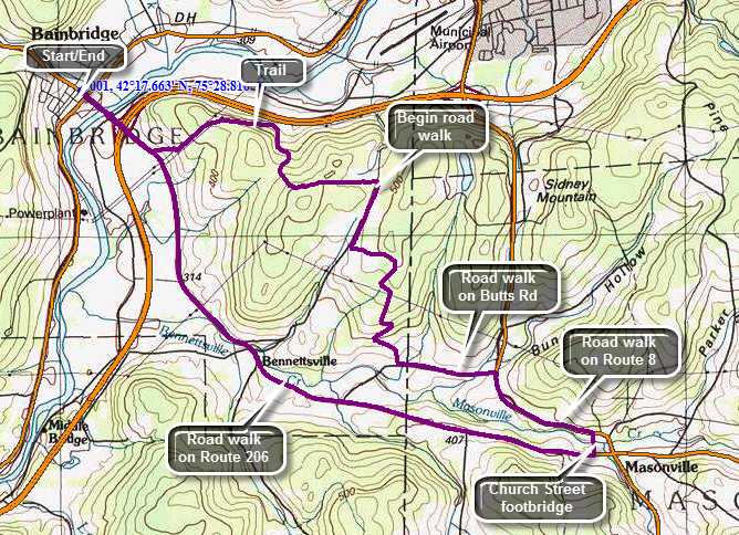 The Finger Lakes Trail is a primitive footpath that starts in Allegheny State Park on the New York - Pennsylvania border and extends 576.5 miles to end in the Catskill Park at the beginning of the Table Peekamoose Trail off the Phoenicia East Branch Trail near the Denning trailhead. There are other side trails which increase the length of the trail system. Four hundred miles of this trail is also part of the Scenic North Country Trail. The Finer Lakes Trail Conference celebrated its 50th Anniversary on June 2, 2012. To commemorate the occasion the Conference set up a series of hikes that would cover the entire length of the trail. Hikes varied in length and difficulty from 4 to 14 miles. The Trail Conference continues to improve the trails and to move sections from roads to trails.
This hike should be done with a car spot since the round trip hike is 16.1 miles! The route described here is a loop using roads for the return trip! Go to Bainbridge and park in the municipal parking lot near the old train station. Walk southeast on Route 206 crossing the Susquehanna River and coming to the traffic circle. Continue through the circle staying on Route 206 and passing under I-88. The trail will cut off to the left just after a yellow house on the right about a mile into the hike. The trail goes through a field and then begins to ascend a hill. You will pass a trail register as you climb the hill. At about 1.25 miles you will to a power line right-of-way where the trail all but disappears. Depending on the season there can be some difficult weeds to push through accompanied by some nasty thorns. At about the time you will want to give up toy will come to an access road to the power lines where the vegetation diminishes. There are few markings along the way. At about 1.6 miles you will come to the top of the climb near a hill labeled "Camel's Hump". The trail follows an access road which cuts under some of the power lines and then parallels another. If the day is clear you should be able to see a nice view of the river valley and the Sidney Airport. The traffic you hear is on I88. Follow the access road under the power lines. until you start to descend a little. At 2.3 miles the trail turns south off the access road and begins to ascend.T his part of the trail is "highly eroded" and quickly deteriorates into a streambed with steep banks. You can try walking on the narrow path along the high banks but both side are undercut and the path often collapses. The best plan may be to give up and simply walk in the streambed. After .85 miles and a gain of 450 feet the trail levels off and becomes a woods road. The road heads due east toward Neff hill Road with a few small ascent and descents. At about 4 miles into the hike, the trail ends on Neff Hill Road where you should turn right. The rest of the hike will be all on roads! Walk up a small hill and then start a descent to Highland Acres Road at 4.7 miles. A brief uphill walk brings you to a right turn on Houck Road Extension. The next turn is a left on Houck Road. Over the next 1.2 miles you will drop about 400 feet to Butts Road. Along the way there are some nice views of the countryside. Turn left onto Butts Road at the bottom of the hill to head into Masonville. At the junction with Route 8 turn right to head toward Masonville which is 1.2 miles away. As you approach Masonville, turn right on Church Street and walk to the footbridge over Masonville Creek. Walk across the bridge and to the end of Church Street. Turn right on Route 206 and head back to Bainbridge. At 11.6 miles you will be at the intersection of Butts Road and Route 206. The rest of the hike back to Bainbridge is mostly downhill. There were some nice views along the way. At 15.1 miles you will at the point where you turned into the field to follow the trail much earlier in the day. It is about a mile back to the car.
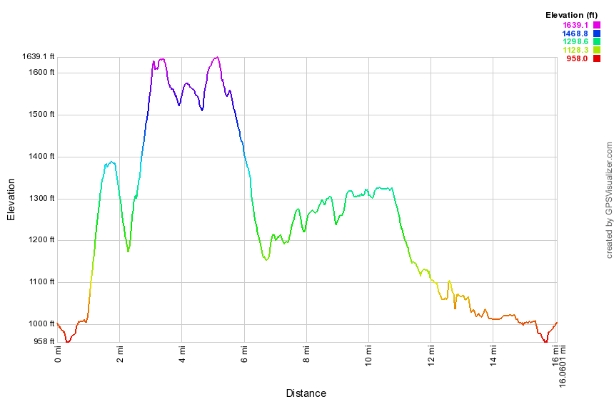 (The image at the left shows the profile of the hike. Remember that all vertical profiles are relative!)
Finger Lakes Trail: Shears Road to Masonville
| Quick Look | ||||
|---|---|---|---|---|
| Difficulty | Round trip | Total climb | Internet Maps | |
| 12.7 mi. | 2370 ft. | AllTrails | ||
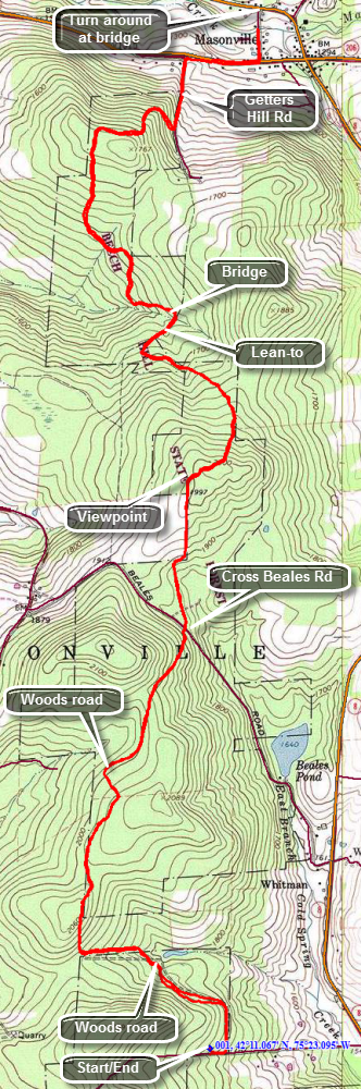 The Finger Lakes Trail is a primitive footpath that starts in Allegheny State Park on the New York - Pennsylvania border and extends 576.5 miles to end in the Catskill Park at the beginning of the Table Peekamoose Trail off the Phoenicia East Branch Trail near the Denning trailhead. There are other side trails which increase the length of the trail system. Four hundred miles of this trail is also part of the Scenic North Country Trail. The Finer Lakes Trail Conference celebrated its 50th Anniversary on June 2, 2012. To commemorate the occasion the Conference set up a series of hikes that would cover the entire length of the trail. Hikes varied in length and difficulty from 4 to 14 miles. The Trail Conference continues to improve the trails and to move sections from roads to trails.
This hike is best done with a car spot as it is 6.4 miles one way. It can be done as an out and back. The route described here is the out and back! Take exit 84, the Deposit exit, on State Route 17. Drive north about 10 miles on Route 8. Watch for signs for Steam Mill State Forest and a parking area on the right. Go past the parking area and watch for an ice cream stand on the left and Hardwood Hills Golf Course on the right. Turn left on Shears Road and watch for the sign for Arctic China State Forest on the right. Park on the left side of the road just passed the sign. Walk back down the road passed the sign and turn left on a woods road to begin your hike. The trail begins on a woods road and is well marked with numerous blazes. Some sections of the Finger Lakes Trail seem to be unused and the blazes are faded and very far apart. This trail is well blazed for the entire length and seems to be used by hikers, bikers and horses. The trail stays on the woods road and heads west for just less than a mile climbing slightly all the way. At this point it turns north and continues to climb to just over a mile before descending to Beales Road. At Beales road there is a trailhead kiosk and limited parking. The trail enters an evergreen forest and winds its way through the trees until again hitting a woods road. The road climbs very gently passing a field on the left. At 3.0 miles there is a viewpoint over the field and across the valley to the west over some hills. A small bench provides a resting spot and was placed there by the TriTown Hikers. After hitting a high point, the trail begins to descend over the next mile. At 4.2 miles there is a blue spur trail to the right. The trail goes to the Getter Hill lean-to just 250 feet off the trail. The lean-to was built in 2011 and has the typical open front with a fireplace but also sports a picnic table, an outhouse and a nearby stream. After the lean-to trail is a low point as you cross a bridge over a stream and then the trail begins to climb again. The trail climbs for about .8 miles and then starts to descend, meeting another woods road. From here it is all downhill to Masonville. At 5.7 miles you will hit Getter Hill Road. Turn left to descend the dirt road which soon turns to pavement. The walk down the road is short. As you near Route 206 turn right on a grassy lane which runs parallel to the road. Once on Route 206 turn right and walk along the road for .2 miles before turning left on Church Street. Just .1 miles more and you will be at the Church Street Bridge which is your destination. The bridge was a road bridge at one time but had been closed to cars. The Finger Lakes Trail Conference donated decking which was installed by the people of Masonville to make a nice foot bridge over Masonville Creek. If you have spotted a car here your hike is over. If your car is back on Shears Road, turn around and retrace your steps! The ascents may seem a little harder on the way back.
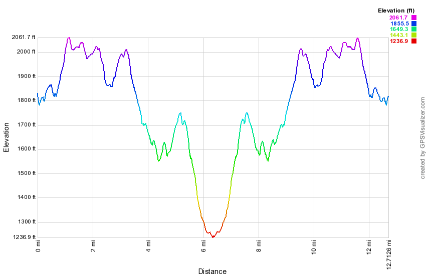 (The image at the left shows the profile of the hike. Remember that all vertical profiles are relative!)
Finger Lakes Trail: Arctic China SF
| Quick Look | ||||
|---|---|---|---|---|
| Difficulty | Round trip | Total climb | Internet Maps | |
| 7.1 mi. | 1360 ft. | AllTrails | ||
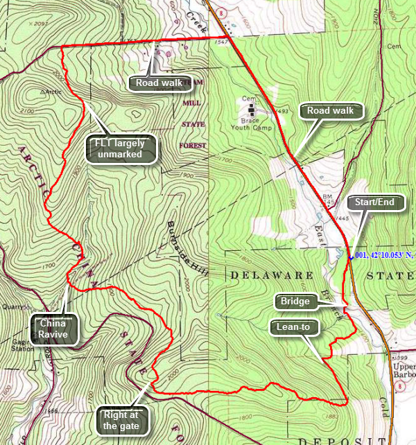 The Finger Lakes Trail is a primitive footpath that starts in Allegheny State Park on the New York - Pennsylvania border and extends 576.5 miles to end in the Catskill Park at the beginning of the Table Peekamoose Trail off the Phoenicia East Branch Trail near the Denning trailhead. There are other side trails which increase the length of the trail system. Four hundred miles of this trail is also part of the Scenic North Country Trail. The Finer Lakes Trail Conference celebrated its 50th Anniversary on June 2, 2012. To commemorate the occasion the Conference set up a series of hikes that would cover the entire length of the trail. Hikes varied in length and difficulty from 4 to 14 miles. The Trail Conference continues to improve the trails and to move sections from roads to trails.
This hike can be done with a car spot, as an out and back or a loop with road walk. The route described here is the loop! Take exit 84, the Deposit exit, on State Route 17. Drive north about 9 miles on Route 8. Watch for signs for Steam Mill State Forest and a parking area on the right. The Finger Lakes Trail crosses here and you will start your hike by crossing Route 8 and walking just slightly to the right. The Finger Lakes Trail is not well marked here but you will pick up the blazes once you walk down the bank. After a short walk through the trees, the trail meets a woods road which takes you down to a stream crossing. A rat5her impressive bridge will get you across the stream as you enter some evergreens on the other side. The trail initially heads south and then west but eventually turns north and heads for Shears Road. For the next .7 miles the trail continues to gain elevation and heads south. At just over 1 mile into the hike it swings west and continues to climb to 1.5 miles. From here the trail descended gradually to an area near Dunbar Road where there is a camping area. When you come to a gate in the middle of the woods, turn right at the Y and you will eventually see some white blazes. The blazes on this entire section of trail are very old. Some blazes are covered by brush and in many areas there are quite far apart. The trail starts to gain elevation to 2.35 miles at which point it starts to drop. At 3 miles you will pass a sign explaining that the area had been planted with hardwoods in the 1903's to create a mixed forest. The hardwoods have now taken over and the softwoods ware being logged to create a hardwood forest. There is an open area on your left from the logging. The trail drops from about 2100 feet to 1650 feet over the next mile as it descends into China Ravine. The ravine itself is wide and impressive but has only a small stream running through it. There is a single plank "bridge" across the stream. Cross the stream and head up the trail parallel to the ravine. By now you will be headed north and the ravine will soon be behind you. The trail gains almost 500 feet over the next 1.2 miles. At times you will be walking through a pine forest with many smaller trees springing up on the forest floor. The smaller trees are crowding the trail and can be a little prickly. There are few if any blazes along this part of the trail. At about 4.5 miles you will enter some hardwoods and a grassy area. Again there are no blazes even when the trail came to another Y. Head right and down a hill toward Shears Road. I found one blaze along the way. When you break out onto Shears Road you may notice that there is no sign to indicate that there is a trail and the "mouth" of the trail has overgrown. Just across from the trail is room for one car on the side of the road. Turn right on Shears Road and walk .75 miles downhill to Route 8. Just after the sign for Arctic State Forest you will see when the Finger Lakes Trail enters the woods on the left along a road and heads north to Masonville. When you get to Route 8 turn right and walk the 1.35 miles back to the parking area.
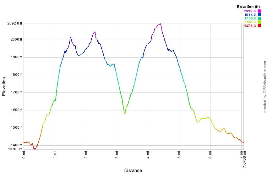 (The image at the left shows the profile of the hike. Remember that all vertical profiles are relative!)
Finger Lakes Trail: Steam Mill SF to Mormon Hollow
| Quick Look | ||||
|---|---|---|---|---|
| Difficulty | Round trip | Total climb | Internet Maps | |
| 10.4 mi. | 2600 ft. | AllTrails | ||
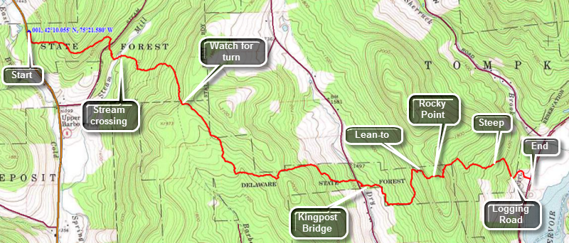 The Finger Lakes Trail is a primitive footpath that starts in Allegheny State Park on the New York - Pennsylvania border and extends 576.5 miles to end in the Catskill Park at the beginning of the Table Peekamoose Trail off the Phoenicia East Branch Trail near the Denning trailhead. There are other side trails which increase the length of the trail system. Four hundred miles of this trail is also part of the Scenic North Country Trail. The Finer Lakes Trail Conference celebrated its 50th Anniversary on June 2, 2012. To commemorate the occasion the Conference set up a series of hikes that would cover the entire length of the trail. Hikes varied in length and difficulty from 4 to 14 miles. The Trail Conference continues to improve the trails and to move sections from roads to trails.
This hike is best done as a car spot as it is 5.2 miles one way! The route described here is out and back! Take exit 84, the Deposit exit, on State Route 17. Drive north about 9 miles on Route 8. Watch for signs for Steam Mill State Forest and a parking area on the right. The Finger Lakes Trail crosses here and leaves the back right corner of the parking area. The trail follows an old logging road and begins to gain some elevation as you walk along a stone wall. The trail description from the Finger Lakes Trail Conference describes a viewpoint at the height of land but it seems to have grown in. There is a view of a logged area but nothing else. Descend the other side of the hill and drop down to Steam Mill Road. Cross the road and then walk across the brook. Next you will hike about .5 miles across some wetlands and then through some evergreens. Eventually this turns to hardwoods until you came out on Barbour Brook Road. Turn left on the road and continue to walk uphill until the trail turns off the road at the beginning of a snowmobile trail. Watch carefully here and DO NOT take the snowmobile trail bow follow the white Finger Lakes Trail blazes over the hill. You will reach a high point of land and then descend a little before climbing again to a ridge. From here the trail descends steeply for the next .6 miles losing 500 feet. At the bottom of the descent you will cross Dry Brook Road and come to a camping area next to the stream. There is a nice kingpost bridge constructed as an Eagle Scout project in 1994. From here you will begin to ascend again as you head for the Dry Brook lean-to. The wettest parts of the trail are spanned by planks held together with screening. Within .2 miles you will pass a blue blazed trail on the left which leads to a cistern for water. Continue to climb and in another .4 miles you will be at the Dry Brook lean-to. It has a fire pit and picnic tables in front. Continue to climb for another .2 miles to Rocky Point. There are several large boulders here which must be of glacial origin since they are on the highest point around. Continued over Rocky Point and then descend steeply on the trail for about .3 miles to a logging road. Turn left on the logging road and follow it and the white blazes for another .7 miles down to Route 27 near the Cannonsville Reservoir. The drop to the road is almost 800 feet! If you have parked a car near here, walk to the car. If your car is back at Steam Mill SF, turn around and hike back!
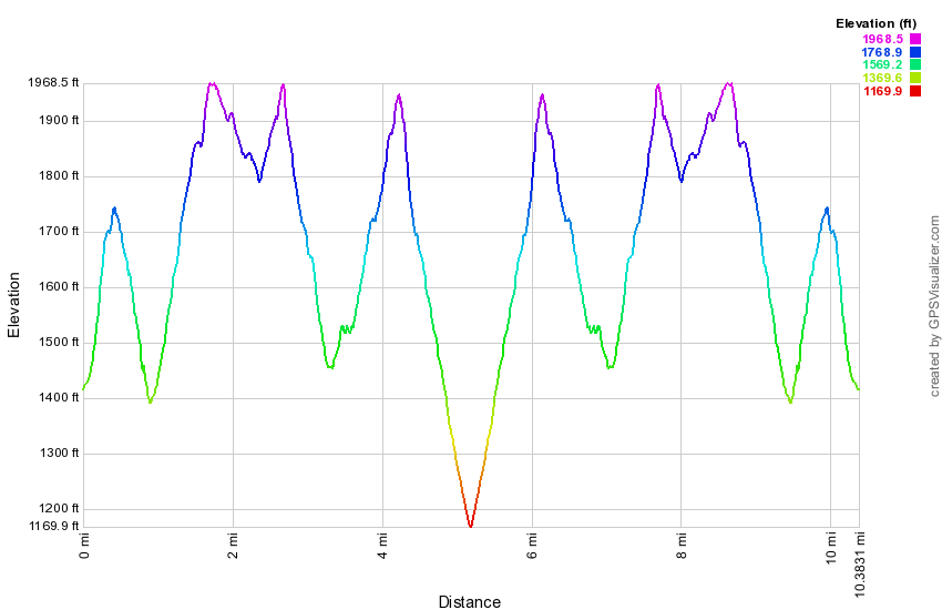 (The image at the left shows the profile of the hike. Remember that all vertical profiles are relative!)
Finger Lakes Trail: Mormon Hollow to Fletcher Road
| Quick Look | ||||
|---|---|---|---|---|
| Difficulty | Round trip | Total climb | Internet Maps | |
| 11.1 mi. | 2380 ft. | AllTrails | ||
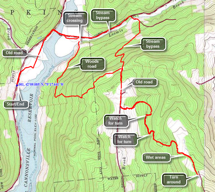 The Finger Lakes Trail is a primitive footpath that starts in Allegheny State Park on the New York - Pennsylvania border and extends 576.5 miles to end in the Catskill Park at the beginning of the Table Peekamoose Trail off the Phoenicia East Branch Trail near the Denning trailhead. There are other side trails which increase the length of the trail system. Four hundred miles of this trail is also part of the Scenic North Country Trail. The Finer Lakes Trail Conference celebrated its 50th Anniversary on June 2, 2012. To commemorate the occasion the Conference set up a series of hikes that would cover the entire length of the trail. Hikes varied in length and difficulty from 4 to 14 miles. The last section is the one described here and is mostly a road walk from The parking area on Black Bear Road (Wild Meadow Road) near Round Pond to the eastern terminus of the trail 1.2 miles from the Denning trailhead.
This hike works best with a car spot since the round trip is over 11 miles one way! The hike described here is out and back. Depending on where you are coming from there are a number of ways to get to Fletcher Road where you will park one car. Perhaps the best way to get there is to take the Cadosia exit from State Route 17 and go north on Route 268 to Route 10. Where Route 268 meets Route 10 is the beginning of the hike where you will park the one car in the lot at the end of the bridge. Drive south on Route 10 about 2 miles and turn right on Dryden Road. Drive north on Dryden Road and turn left after 1.5 miles on Finch Hollow Road. Turn left on Fletcher Road which is a gravel road that turns to a woods road with enough clearance for most cars. Park near the end of the road. Drive back down Dryden Road to Route 10 and turn right. Drive about 4.6 miles to Route 27 and turn right. Drive north 4.6 miles and park on the right shoulder near a boat launch. To begin the hike walk north on Route 27 for about .1 miles to the point where the Finger Lakes Trail crosses the road. Step over the right guardrail and walk to trail down to an old road. Turn left on the road and walk along the trail which parallels Route 27 until it meets Route 47. The trail will take you back up to Route 27 for a short distance where you should turn right on Route 47. In about .5 miles the Finger Lakes Trail will turn right and enter the woods. Watch for the white blazes as you pass through some pines since the trail is not well defined. You will soon be at the edge of Loomis Brook which does not have a bridge crossing. There is a steel cable to hang onto. If you absolutely cannot cross here there is a bypass route which is described here later. After crossing the brook you will ascend on a wide woods road for about 1.25 miles gaining around 800 feet. At the top is a nice pine grove and the trail levels briefly as you walk .6 miles on a woods road across the ridge. At 3.25 miles into the hike, the trail turn sharply right on Old Chamberlain Road. Walk down the road through the forest and then out into a field. You will arrive at Chamberlain Road at about 3.6 miles. Turn right and walk down the road for only about .1 miles. Watch for an FLT disk on a pole on the left side of the road and an FLT sign across a small field against the wood line. Cross a brook on a foot bridge and begin to be very careful about watching for the white blazes. The next section of trail is not well marked in critical places. It is also wet and muddy in spots. Walk uphill to about 4.3 miles where the trail turns right and then almost immediately right again. You will descend slightly to a woods road where you will turn left and follow the road to about 4.6 miles. You will be in an area dominated by pine trees and where the blazes seem to disappear. The trail goes up the bank on your left and hooks back on itself slightly. Once you make this left turn the blazing gets better. At 4.9 miles you will be on a height of land but to get to the end of Fletcher Road you will have to walk another .8 miles and descend 400 feet! You will come out into an open area where you may have parked a car for the return trip.
If you did not have two cars, you will have to hike back to your car by reversing your route. There are some options along the way. First you will have to turn around and climb the .8 miles and 400 feet you just descended. From the top walk down the other side to Chamberlain Road, turn right, walk back to Old Chamberlain Road and turn left to walk through the field and forest. At he right hand turn at the top of Old Chamberlain Road, around 8.1 miles you will see the blue blazes of the high water bypass route. This is the route you may use if Loomis Brook is too high to cross. Walk straight ahead and follow the bypass trail as it descends through several switchbacks on a woods road. Continue to follow the blazes fro about a mile until you are on Lewis Road where you will turn left and walk down to Route 47. Turn left on Route 47 and walk towards Route 27. At around 9.85 miles the bypass trail turns left into the woods to pick up the main Finger Lakes Trail through the stand of pines. The walk lasts only .2 miles when you will be back on Route 47 so you may elect to stay on the road. Walk out to Route 27 and turn left. You may walk the road for .8 miles back to the car or follow the Finger Lakes Trail by turning left on the trail and continuing back the way you came.
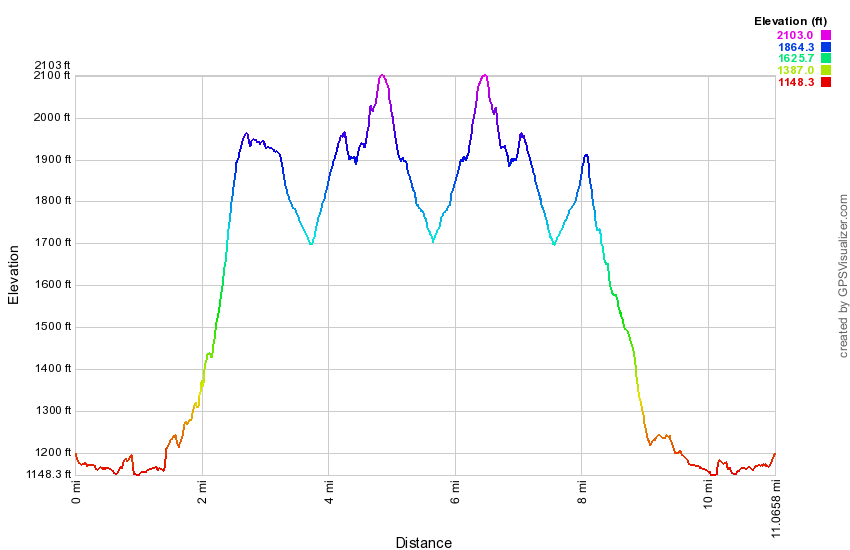 (The image at the left shows the profile of the hike. Remember that all vertical profiles are relative!)
Finger Lakes Trail: Apex Bridge to Fletcher Road
| Quick Look | ||||
|---|---|---|---|---|
| Difficulty | Round trip | Total climb | Internet Maps | |
| 12.3 mi. | 2480 ft. | AllTrails | ||
_map.png) The Finger Lakes Trail is a primitive footpath that starts in Allegheny State Park on the New York - Pennsylvania border and extends 576.5 miles to end in the Catskill Park at the beginning of the Table Peekamoose Trail off the Phoenicia East Branch Trail near the Denning trailhead. There are other side trails which increase the length of the trail system. Four hundred miles of this trail is also part of the Scenic North Country Trail. The Finer Lakes Trail Conference celebrated its 50th Anniversary on June 2, 2012. To commemorate the occasion the Conference set up a series of hikes that would cover the entire length of the trail. Hikes varied in length and difficulty from 4 to 14 miles. The last section is the one described here and is mostly a road walk from The parking area on Black Bear Road (Wild Meadow Road) near Round Pond to the eastern terminus of the trail 1.2 miles from the Denning trailhead.
The Finger Lakes Trail is a primitive footpath that starts in Allegheny State Park on the New York - Pennsylvania border and extends 576.5 miles to end in the Catskill Park at the beginning of the Table Peekamoose Trail off the Phoenicia East Branch Trail near the Denning trailhead. There are other side trails which increase the length of the trail system. Four hundred miles of this trail is also part of the Scenic North Country Trail. The Finer Lakes Trail Conference celebrated its 50th Anniversary on June 2, 2012. To commemorate the occasion the Conference set up a series of hikes that would cover the entire length of the trail. Hikes varied in length and difficulty from 4 to 14 miles. The last section is the one described here and is mostly a road walk from The parking area on Black Bear Road (Wild Meadow Road) near Round Pond to the eastern terminus of the trail 1.2 miles from the Denning trailhead.
This hike works best with a car spot since the round trip is over 12 miles! Parking one car at the end of Fletcher Road and beginning the hike at the Apex Bridge is one option. The hike described here is a loop using some roads on the return trip. Depending on where you are coming from there are a number of ways to get to Fletcher Road where you will park one car. Perhaps the best way to get there is to take the Cadosia exit from State Route 17 and go north on Route 268 to Route 10. Where Route 268 meets Route 10 is the beginning of the hike where you will park the one car in the lot at the end of the bridge. Drive south on Route 10 about 2 miles and turn right on Dryden Road. Drive north on Dryden Road and turn left after 1.5 miles on Finch Hollow Road. Turn left on Fletcher Road which is a gravel road that turns to a woods road with enough clearance for most cars. Park near the end of the road. When you get back to the Apex Bridge and are parked in the lot, walk across the road, turn left and walk north on Route 10 a very short distance to the first section of guardrail. This is where the trail starts! The beginning of the trail is rather steep but it soon levels off and begins to descend a little. The trail rolls through some gullies and finally at 1.25 miles turns left onto the woods road that once acted as an access road to the tower. The climb to the tower is steep in places but the crew who constructed the trail built in a few switchbacks to help. Over the next 1.5 miles you will be headed due north gaining a total of over 1400 feet from the parking area. The difference in elevation from the point where you turned onto the woods road is over a 1000 feet and several ascents are more than a 25% grade. At 2.8 miles you will be at the base of the tower. The bottom flights of stairs have been removed from the tower to discourage anyone from ascending and the cab is in disrepair. There is a plan to restore the tower which would be a wonderful project. The next part of the trail heads passed the tower and starts to descend. Although the trail generally loses elevation there are times when it climbs again. At about 3.1 miles the trail joins a dirt road and follows it to a bluestone quarry at 3.4 miles. Stone is still being cut here but it is not in operation every day. Continue on the road through the other side of the quarry. Soon there is a turn to the right which may not marked but is pretty obvious. Continue to follow various woods roads for the most part. Occasionally the trail will cut through the woods to get to the next road. At 3.7 miles the trail heads south instead of west and remains on then ridge where the elevation is still over 2100 feet. At 4.2 miles the trail again turns west and begins a steep descent toward Faulkner Road. Over the next .7 miles you will lose 750 feet of elevation for an average grade of 25%. You will reach the junction with the previous trail at 4.9 miles. The trail is now marked with blue blazes. Continue straight ahead on the main trail. You will descend and cross Faulkner Road at 5.4 miles. Continue across the road on the trail and follow it through some wet areas until it eventually meets Dryden Road at about 6.0 miles. Turn right on the road and walk to a Y. Turn left on Finch Hollow Road and walk short distance before turning left on Fletcher Road. This gravel road now begins an ascent and eventfully turns into a woods road in good condition. You will pass only one house on the way. A stream flows on the left side of the road. Walk about .75 miles on Fletcher Road gaining over 400 feet until you emerge in an open area where you may have parked another car. The Finger Lakes Trail goes straight ahead and into the woods. This is your turn around point if you do not have another car. Turn around and walk back down Fletcher Road, turn right on Finch Hollow Road and right on Dryden Road. At 9.4 miles you will reach the point where the trail enters the woods on the left side of Dryden Road. Continue on Dryden Road for another .8 miles until it meets Route 10 at 10.3 miles. Turn left on Route 10 and walk south on the wide shoulder for 2 miles back to your car at the Apex Bridge parking area. This return route is MUCH easier than the hike out as it is only 4.5 miles instead of 7.7 miles and is primarily downhill or flat.
_gra.png) (The image at the left shows the profile of the hike. Remember that all vertical profiles are relative!)
(The image at the left shows the profile of the hike. Remember that all vertical profiles are relative!)
Finger Lakes Trail: Apex Bridge to Chase Brook Road
| Quick Look | ||||
|---|---|---|---|---|
| Difficulty | Round trip | Total climb | Internet Maps | |
| 5.4 mi. | 610 ft. | AllTrails | ||
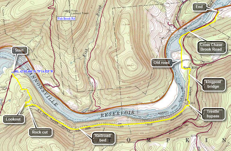 The Finger Lakes Trail is a primitive footpath that starts in Allegheny State Park on the New York - Pennsylvania border and extends 576.5 miles to end in the Catskill Park at the beginning of the Table Peekamoose Trail off the Phoenicia East Branch Trail near the Denning trailhead. There are other side trails which increase the length of the trail system. Four hundred miles of this trail is also part of the Scenic North Country Trail. The Finger Lakes Trail Conference celebrated its 50th Anniversary on June 2, 2012. To commemorate the occasion the Conference set up a series of hikes that would cover the entire length of the trail. Hikes varied in length and difficulty from 4 to 14 miles. The last section is the one described here and is mostly a road walk from The parking area on Black Bear Road (Wild Meadow Road) near Round Pond to the eastern terminus of the trail 1.2 miles from the Denning trailhead.
This hike works well with a car spot since the round trip is over 10 miles! Depending on where you are coming from there are a number of ways to get to Chase Brook Road where you will park one car. Chase Brook Road is about 7 miles south of Walton on Route 10. You can also take the Cadosia exit from State Route 17 and go north on Route 268 to Route 10. Where Route 268 meets Route 10 is the beginning of the hike where you will park the second car. Park a car in the parking area where Route 10 meets Chase Brook Road. Drive in the second car back to the Apex Bridge and park in the lot just after the bridge. Cross the bridge to begin the hike. After crossing the bridge watch for the white blazes of the Finger Lakes Trail on the left. The first .7 miles of the hike through the woods winds through mixed hardwood and evergreen forest gaining about 360 feet in the process. Some of the trail is one old woods roads. At the 1.0 mile mark you can walk off the trail to the right to a small ledge with a limited view. Back on the main trail a very short walk will bring you to a had left turn. You are now on the railroad bed of the Ontario and Western railroad and will stay on the rail bed for some time. You will immediately notice that you are passing through a rock cut and that there are no visible drill marks on the rock. The quarrymen who made the cut used the natural fissures in the rock. Near the end of the cut on the right side is a stone wall laid up to hold the bank in place. The rocks are covered with moss but the workmanship is still evident. For the next 2.5 miles you will be walking along the flat and straight rail bed. It can be wet in places but the trail is well marked. If you keep looking to the left you will see the foundations of a springhouse around the 2.3 mile mark. The water here is plentiful and clear. At 3.55 miles the trail leaves the railroad bed to the right and crosses a stream on a small bridge. This was necessary since the railroad crossed a trestle in this area and the trestle is no longer there! After this point the railroad bed has collapsed in several places but the trail is easy to follow. You will cross two more bridges. The last bridge is a kingpost bridge over a small stream that swells greatly with heavy rain. At 4.15 miles you will be approaching Chase Brook Road. Watch for FLT signs pointing to the left. Turn left and walk downhill to an old road. At the T, turn right and follow the old road. This can be difficult since the blazes are few and far between and the knotweed has overgrown the trail in many places. After you clear the knotweed, you will come to a grassy area and will see a gate at the top of a small hill. Walk up to the gate and across Chase Brook Road. Then trail continues on the other side and will take you to the end of Chase Brook Road where you parked a car.
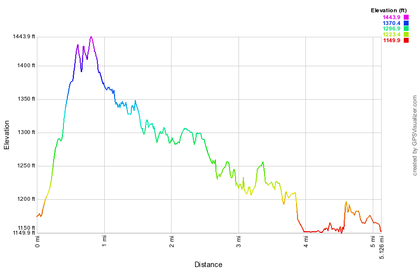 (The image at the left shows the profile of the hike. Remember that all vertical profiles are relative!)
Finger Lakes Trail: Beers Brook Road to Chase Brook Road
| Quick Look | ||||
|---|---|---|---|---|
| Difficulty | Round trip | Total climb | Internet Maps | |
| 5.1 mi. | 570 ft. | AllTrails | ||
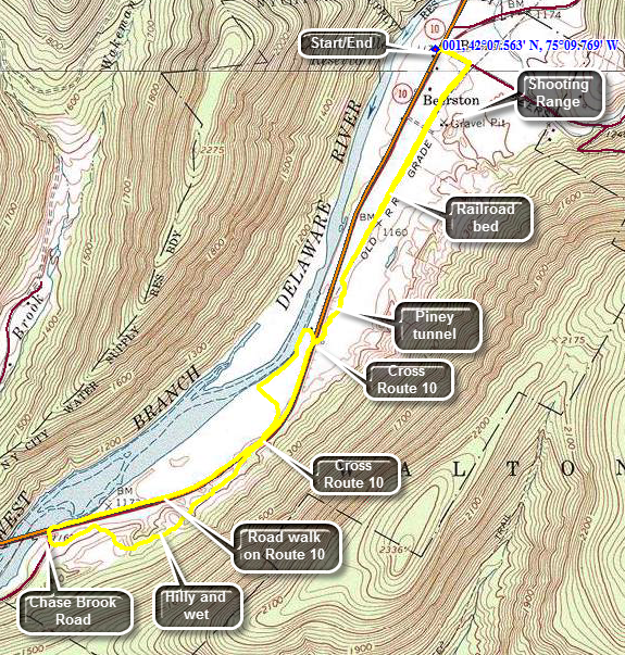 The Finger Lakes Trail is a primitive footpath that starts in Allegheny State Park on the New York - Pennsylvania border and extends 576.5 miles to end in the Catskill Park at the beginning of the Table Peekamoose Trail off the Phoenicia East Branch Trail near the Denning trailhead. There are other side trails which increase the length of the trail system. Four hundred miles of this trail is also part of the Scenic North Country Trail. The Finer Lakes Trail Conference celebrated its 50th Anniversary on June 2, 2012. To commemorate the occasion the Conference set up a series of hikes that would cover the entire length of the trail. Hikes varied in length and difficulty from 4 to 14 miles. The last section is the one described here and is mostly a road walk from The parking area on Black Bear Road (Wild Meadow Road) near Round Pond to the eastern terminus of the trail 1.2 miles from the Denning trailhead.
Depending on where you are coming from there are a number of ways to get to Beers Brook Road where you will park your car. Beers Brook Road is about 5 miles south of Walton on Route 10. You can park directly across from Beers Brook Road or in the parking area slightly further north. Walk across Route 10 and listen for gunfire on the shooting range just off Beers Brook road. If you hear shooting walk south on Route 10 watching for blue blazes on the left side of the road. Turn left and follow these blue blazes to the main FLT where you should turn right. If there is no shooting, walk up Beers Brook Road for only about .1 miles and turn right on the FLT. At just less than a mile the trail goes to the left and off the old road entering a stretch of pine trees. It is usually cool in this area and the pine needles make a soft footing. At 1.2 miles the trail enters an open area and then crosses Route 10. Turn right or north on Route 10 and watch for the FLT signs. The trail wanders down to a path along the West Branch of the Delaware and the Cannonsville Reservoir. This part of the trail is pretty but also pretty buggy in season. At 1.5 miles the trail leaves the path and turns left crossing a field of tall grass and ending up at the base of the bank that forms Route 10. Walk along the base of the bank until it slowly begins to climb up to Route 10. At 1.7 miles you will again be at Route 10. Turn right or south and walk a few hundred feet until the Finger Lakes Trail sign appears on the left. The trail here cuts up into the woods and begins to get wetter and muddier. The trail for the next .8 miles rolls up and down over some little hills but continues to be wet. At around 2.5 miles you will at Chase Brook Road. To get back you can retrace your steps he the trail or walk back on Route 10. The distance on Route 10 is 2 miles and it is flat and boring! A nice option is to walk about to the first crossing you made of Route 10 at about 3.65 miles. Turn right here and go back into the woods and through the pine grove. From here retrace your route from earlier to get back to your car.
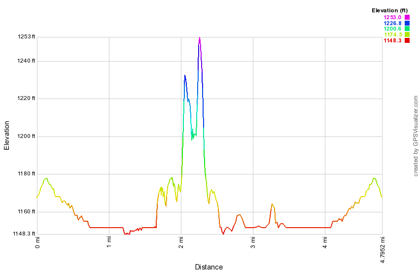 (The image at the left shows the profile of the hike. Remember that all vertical profiles are relative!)
Finger Lakes Trail: Houck Mt from Beers Brook
| Quick Look | ||||
|---|---|---|---|---|
| Difficulty | Round trip | Total climb | Internet Maps | |
| 9.5 mi. | 1950 ft. | AllTrails | ||
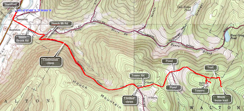
Take NYS Route 10 east from Walton for about 4.7 miles until you pass South River Rd on the left. Park in the parking area across the road. Walk east on Route 10 away from South River Road and after a few hundred feet turn left on Beers Brook Road. Walk about half a mile and turn right on Houck Mountain Road. The sign is hidden on the left side of the road as you make the turn. You may also see a few white blazes for the Finger Lakes Trail but these are few and very far between. Be prepared for a continuous climb over the next 1.8 miles and a gain of over 1000 feet in elevation. There are very few views especially when the leaves are on the trees but the walk is on a road which allows a good pace. After a very short descent, DOT Tower Road is a left turn. It is marked by a small Garden and a prominent sign and cannot be missed. The road rises just a little and then starts to descend to the communications towers near the top. Along the way there are several cottages or cabins and two small but pretty ponds on the right side of the road. After walking about 1.4 miles on Tower Road a sign indicates that the Finger Lakes Trail turns to the left onto some trails. Turn left here and stay on the main trail for .4 miles when the trail intersects one of the many trail in Bear Spring Wildlife Management Area. Turn to the left here to continue on the Finger Lakes Trail over Fork Mountain and into Downsville. Turn around and walk back to the main trail. If time allows, turn left and walk up to the communications towers. The array of cables is impressive. When you are ready to return, turn around a retrace your steps back to the car. The return trip is MUCH faster as it is almost completely downhill! A better way to hike this is to use a car shuttle and park one car on Route 10 and the other in Downsville or some other location.
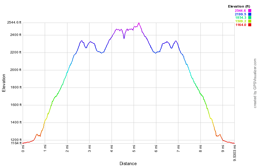 (The image at the left shows the profile of the hike. Remember that all vertical profiles are relative!)
Finger Lakes Trail: Houck Mt to Horse Camp
| Quick Look | ||||
|---|---|---|---|---|
| Difficulty | Round trip | Total climb | Internet Maps | |
| 7.9 mi. | 870 ft. | AllTrails | ||
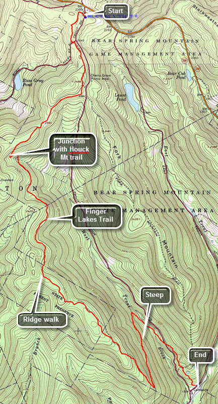 The Finger Lakes Trail is a primitive footpath that starts in Allegheny State Park on the New York - Pennsylvania border and extends 576.5 miles to end in the Catskill Park at the beginning of the Table Peekamoose Trail off the Phoenicia East Branch Trail near the Denning trailhead. There are other side trails which increase the length of the trail system. Four hundred miles of this trail is also part of the Scenic North Country Trail. The Finer Lakes Trail Conference celebrated its 50th Anniversary on June 2, 2012. To commemorate the occasion the Conference set up a series of hikes that would cover the entire length of the trail. Hikes varied in length and difficulty from 4 to 14 miles. The Trail Conference continues to improve the trails and to move sections from roads to trails.
This hike is best done as a car spot as it is 7.9 miles one way! Take County Route 206 to the top of Bear Spring Mountain near Walton, NY. Turn into the park on West Bear trout Brook Road which is the main entrance. Only a few hundred feet in there will be a large trail head parking area on the left. There is a large hand-painted wooden sign that shows the numbers horse trails. Memorize it since the copies, if there are any, at he trail junctions are useless. Note also that there are many additional trails and roads that form loops and are not shown on any maps.
Exit the parking area on the trail across the road which should be Trail 7. Within .5 miles you will cross Beers Brook Road and the trail continues on the other side as it parallels West Trout Brook Road. The trail is wide open and grassy and wanders back and forth across the ridge and generally gains a little elevation. At 1.1 miles the trail bears to the right and continues until it meets the trail to the Houck Mountain towers at about 2.2 miles. Turn left and walk a short distance to the next junction and turn right staying on the horse trail marked with the blue horse trail markers. There are few markers that designate the trail numbers and at some point Trail 7 changes to Trail 6 at least according to the sign back at trail head. As you walk along the ridge for the next 3.25 miles to the south and then southeast, you may begin to wonder if you are going the right way. At the and of the ridge the trail starts to descend for about .45 miles to a switchback almost 6 miles into the hike! After the switchback, walk about .8 miles to the next switchback and then another .5 miles to West Trout Brook Road. You will be about 7.3 miles into the hike and will have dropped almost 1000 feet from the ridge. Cross the road and walk a little to the right to continue on Trail 6. Now its time to regain that 1000 feet you dropped!
From the road the trail ascends briefly and then drops through a stand of spruce trees before climbing again to a trail junction within .35 miles of the road. Finally a trail that is clearly marked! Turn right and go downhill for only about .25 miles to the parking area where West Trout Brook, East Trout Brook and Trout Brook all meet.
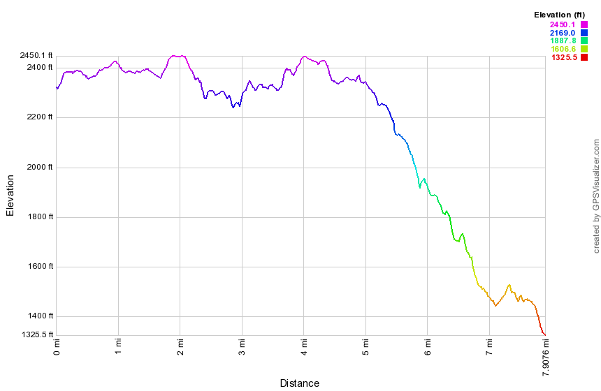 (The image at the left shows the profile of the hike. Remember that all vertical profiles are relative!)
Finger Lakes Trail: Horse Camp to Downsville
| Quick Look | ||||
|---|---|---|---|---|
| Difficulty | Round trip | Total climb | Internet Maps | |
| 6.5 mi. | 1263 ft. | AllTrails | ||
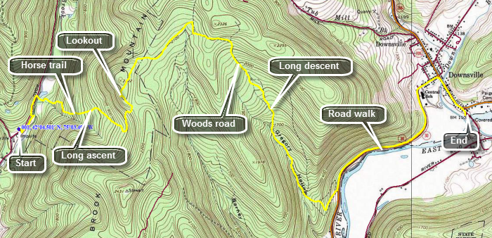 The Finger Lakes Trail is a primitive footpath that starts in Allegheny State Park on the New York - Pennsylvania border and extends 576.5 miles to end in the Catskill Park at the beginning of the Table Peekamoose Trail off the Phoenicia East Branch Trail near the Denning trailhead. There are other side trails which increase the length of the trail system. Four hundred miles of this trail is also part of the Scenic North Country Trail. The Finer Lakes Trail Conference celebrated its 50th Anniversary on June 2, 2012. To commemorate the occasion the Conference set up a series of hikes that would cover the entire length of the trail. Hikes varied in length and difficulty from 4 to 14 miles. The Trail Conference continues to improve the trails and to move sections from roads to trails.
This hike is best done as a car spot as it is 6.5 miles one way! Park one car at the covered bridge park on Bridge street in Downsville, NY. Drive north from Downsville on Route 206. At the top of Bear Spring Mountain watch for East Trout Brook Road on your left. Turn left and follow this road to its intersection with West Trout Brook Road. There will be a large parking area on the right near the end with a DEC Horse Camp across the road. Park in the large lot on your right. After parking, start your hike by walking down to the road. It is possible to continue ahead into the camping area and take Trail 8 to where it crosses East Trout Brook. The problem with this approach is that the brook is often too high to cross without getting wet at the start of your hike. A better approach may be to hike about .3 miles up to the road to a snowmobile bridge on the right side of the road which crosses East Trout Brook. After crossing then bridge, take a left at the trail junction and walk a short distance to a field. Turn right and walk up the right edge of the field to begin your ascent to the ridge on Trail 12. This trail ascends to the top of the ridge over the next 1.1 miles and gains about 860 feet of elevation. At 1.7 miles you will be at the top of the ridge and there is a short side trail that leads to a lookout on the left. Take advance of the view as it is the ONLY viewpoint on the hike. The trail now levels out and actually descends some to 2.0 miles where the FLT leaves the horse trail to the right. The first few hundred feet may seem rough but soon you will join a well-defined woods road. The road mat be wet in many places and wet means insects. be sure you bring your favorite insect repellant! The road at first heads northeast and east but at about 3 miles it turns southeast and starts to descend. Over the next 1.8 miles you will lose about 1125 feet of elevation. At the bottom of the road, turn left on Route 30 and walk 1.4 miles to the stoplight in Downsville. Turn right at the light and walk down Main Street to Bridge Steep where you parked your car.
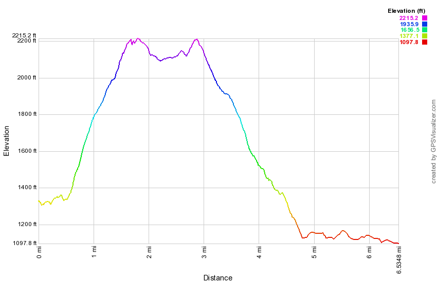 (The image at the left shows the profile of the hike. Remember that all vertical profiles are relative!)
Finger Lakes Trail: Rt 206 to Downsville
| Quick Look | ||||
|---|---|---|---|---|
| Difficulty | Round trip | Total climb | Internet Maps | |
| 7.0 mi. | 1136 ft. | AllTrails | ||
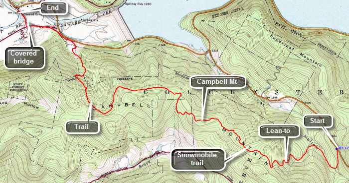 The Finger Lakes Trail is a primitive footpath that starts in Allegheny State Park on the New York - Pennsylvania border and extends 576.5 miles to end in the Catskill Park at the beginning of the Table Peekamoose Trail off the Phoenicia East Branch Trail near the Denning trailhead. There are other side trails which increase the length of the trail system. Four hundred miles of this trail is also part of the Scenic North Country Trail. The Finer Lakes Trail Conference celebrated its 50th Anniversary on June 2, 2012. To commemorate the occasion the Conference set up a series of hikes that would cover the entire length of the trail. Hikes varied in length and difficulty from 4 to 14 miles. The Trail Conference continues to improve the trails and to move sections from roads to trails.
This hike is best done as a car spot as it is 7 miles one way! Park one car at the covered bridge park on Bridge street in Downsville, NY. Drive east from Downsville on Route 30. Turn right on Route 206 toward Roscoe. From the turn, drive a little over 2 miles to where the FLT cross the road and there is a small parking area on the right side of the road. After parking, start your hike by walking down the trail on the right side of the road. The trail descends until about .7 miles when it starts to climb. Several switchbacks over the next .9 miles make the 600 foot climb easier. On the ascent you will pass the Campbell Mountain lean-to on your left. At about 1.6 miles, near the top of the climb, turn right at the FLT sign and register at the box. The trail follows a snowmobile trail and relies on the red markers to guide the hiker. There are few FLT white blazes or signs on this route and, at times, you may wonder if you are still on the trail. At around 3.3 miles watch for a "Downsville" sign on the right side of the trail and turn here. Missing this sign can be easy and will leave you wondering where you are! This trail again is not well marked but remains easy to follow as it passes around he north side of a hill as it travels west toward Downsville. If you look to your right you may be able to spot the Pepacton Reservoir especially when there are fewer leaves on the trees. At about 4.8 miles, watch for a turn to the right as the LT now leaves the snowmobile trail and heads down to another woods road. There are white blazes here but you may have to look closely to see them. At about 5.5 miles the trail again turns right and down the hill to pick up another woods road. This road parallels a stream until it crosses that stream and you enter the backyard. Stay to the right and walk to the driveway of the residence. At the end of the driveway, turn left on Mink Brook Road. Walk down to Back River Road and continue straight ahead. Take the first street on the right which is bridge street. Walk down the street and over the covered bridge to the car you parked there earlier.
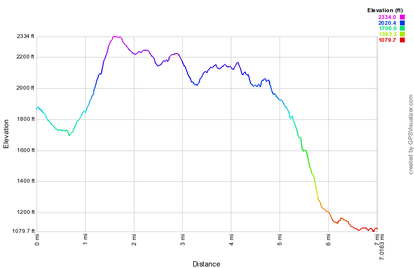 (The image at the left shows the profile of the hike. Remember that all vertical profiles are relative!)
Finger Lakes Trail: Brock Mountain to Berry Brook Rd
| Quick Look | ||||
|---|---|---|---|---|
| Difficulty | Round trip | Total climb | Internet Maps | |
| 6.4 mi. | 1824 ft. | AllTrails | ||
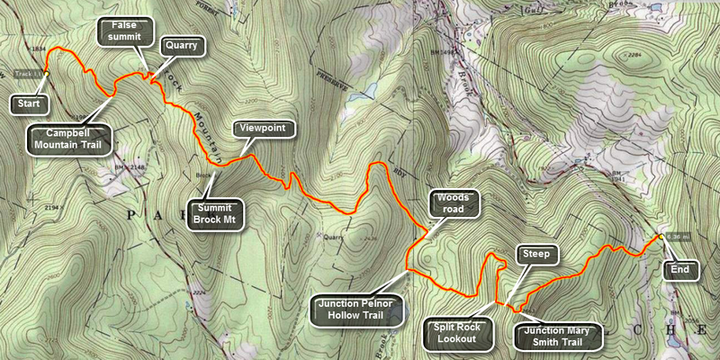 The Finger Lakes Trail is a primitive footpath that starts in Allegheny State Park on the New York - Pennsylvania border and extends 576.5 miles to end in the Catskill Park at the beginning of the Table Peekamoose Trail off the Phoenicia East Branch Trail near the Denning trailhead. There are other side trails which increase the length of the trail system. Four hundred miles of this trail is also part of the Scenic North Country Trail. The Finer Lakes Trail Conference celebrated its 50th Anniversary on June 2, 2012. To commemorate the occasion the Conference set up a series of hikes that would cover the entire length of the trail. Hikes varied in length and difficulty from 4 to 14 miles. The last section is the one described here and is mostly a road walk from The parking area on Black Bear Road (Wild Meadow Road) near Round Pond to the eastern terminus of the trail 1.2 miles from the Denning trailhead.
This is a one way hike that requires a car shuttle or you will have to double the distance to 12.8 miles! Another option is to have someone pick you up at the other end. Head out of Roscoe on Route 206. Turn right on Berry Brook Road just after the county line and drive for around 8 miles to the trail head parking on the right. Drop one car here and continue on Berry Brook Road to Route 30 on the Pepacton Reservoir. Turn left and continue around the reservoir to the junction with Route 206/Route 7. Turn left and drive 2.2 miles to a small parking area on the right side of the road. Park here and cross the road to pick up the blue-blazed Campbell Mountain Trail.
The trail is a wide woods road at the beginning and stays this way for most of its length. There is an immediate ascent through hardwood forest. Hiking this trail can be a real pain or a great pleasure depending on the trail maintenance. This trail is part of the Finger Lakes Trail system and is maintained by their volunteers. Blowdowns can be a problem but the bigger problem is the dense stands of prickers that can obscure the trail. For the first .5 miles the trail gains 450 feet with a few short but steep climbs. After that, it goes through the first of several switchbacks to give hikers a rest before gaining another 230 feet over the next .4 miles. At about 1 mile you reach the false summit of Brock Mountain which, on many maps and GPS units, is marked as Brock Mountain. In this area you may begin to notice piles of rock that do not look natural> There is a rather large quarry off the trail to the left. You may be able to find a woods road that leads to it but the bushwhack is easy. You will see piles of rock and a large and deep pit. When you have explored, work your way back up out of the pit and back to the trail. Back on the trail it is time to tackle the rest of the ascent up the "real" Brock Mountain. After a slight descent from the false summit, the trail ascends about 300 feet to the top of Brock Mountain at about 1.9 miles into the hike. The trail does not actually pass over the highest point on the mountain where there is purported to be a USGS benchmark but it tops out at about 2440 feet. As you start down the other side of Brock Mountain there will be a rather steep descent. Many of the trees are dead and this allows for some interesting views of the valley with another ridge beyond. Continue the hike over trail but be careful to pay close attention to where you are hiking! There are numerous paths and woods roads that cut across the main trail and the trail markers can be few and far between. At about 2.4 miles the trail heads north and then southeast after a short distance. This prominent switchback is not shown on the NYNJTC maps and can be a little confusing. At 3 miles the trail turns almost 90 degrees to the right and heads northeast. Shortly after this, at 3.3 miles, there is another 90 degrees turn to the right and the trail heads southeast. In both cases there are snowmobile trails or woods roads in the area of the turns. There are really no views along the way but the woods can be pretty in any season. In some places there are stone walls and the hint of a foundation. At 3.85 there is another 90 degree turn to the right onto an old road which is eroded but very recognizable with stone walls on both sides. The is a slight uphill but the trail is mostly level for the next .3 miles. At this point the Campbell Mountain Trail ends. To the right is the Little Spring Brook Trail that leads out to Route 206. Turn left onto the Pelnor Hollow Trail. In the next 1 mile the trail climbs over 400 feet through mixed hardwood and evergreen forest. There are some steeper climbs in places along this stretch. Near the top of this climb the trail levels and your reward is the Split Rock Lookout. At the lookout there is a large boulder and an area where part of the bedrock has separated. The views to the west are very good but there isn't much to see other than trees and mountains except for one house on the far ridge. The lookout is about 5.2 miles into the hike. From the lookout the trail ascends for about .1 miles at a 26% grade. This isn't very far but it looks like a WALL from the bottom. At 5.3 miles, turn left on the red Mary Smith Trail as the Pelnor Hollow Trail continues straight ahead. The Mary Smith Trail is an almost continuous downhill to Berry Brook Road. There are a few tricky descent through rocks and around trees. After 1.1 miles and a drop of over 500 feet you should be back at the car. When you come out of the woods and cross the power line right-of-way, watch for the point where the trail reenters the woods on the other side.
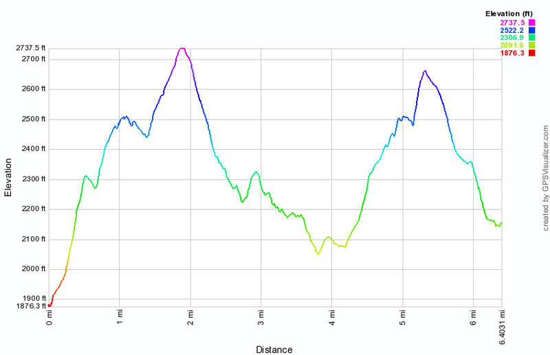 (The image at the left shows the profile of the hike. Remember that all vertical profiles are relative!)
Finger Lakes Trail: Holiday Brook Rd to Route 206
| Quick Look | ||||
|---|---|---|---|---|
| Difficulty | Round trip | Total climb | Internet Maps | |
| 6.4 mi. | 1824 ft. | AllTrails | ||
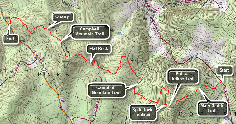 The Finger Lakes Trail is a primitive footpath that starts in Allegheny State Park on the New York - Pennsylvania border and extends 576.5 miles to end in the Catskill Park at the beginning of the Table Peekamoose Trail off the Phoenicia East Branch Trail near the Denning trailhead. There are other side trails which increase the length of the trail system. Four hundred miles of this trail is also part of the Scenic North Country Trail. The Finer Lakes Trail Conference celebrated its 50th Anniversary on June 2, 2012. To commemorate the occasion the Conference set up a series of hikes that would cover the entire length of the trail. Hikes varied in length and difficulty from 4 to 14 miles. The last section is the one described here and is mostly a road walk from The parking area on Black Bear Road (Wild Meadow Road) near Round Pond to the eastern terminus of the trail 1.2 miles from the Denning trailhead.
This hike is simply the above hike in the reverse direction which loses 300 feet in elevation. This is a one way hike that requires a car shuttle or you will have to double the distance to 12.8 miles! Another option is to have someone pick you up at the other end. Head out of Roscoe on Route 206. After passing over the top of Brock Mountain, watch for the place where the trail crosses the road just down the hill from Jug Tavern Road. Pull into the small parking area on the left. Leave a car here and load your gear into the other vehicle. Drive north toward the Pepacton Reservoir on Route 206. Turn right on Route 30. After 4.6 miles, turn right on Holiday Brook Road and drive another 2.8 miles to the trailhead parking on the left.
The trail varies from a wide woods road to a narrow foot trail along its entire length. Hiking this trail can be a real pain or a great pleasure depending on the trail maintenance. This trail is part of the Finger Lakes Trail system and is maintained by their volunteers. Blowdowns can be a problem but the bigger problem is the dense stands of prickers that can obscure the trail. Cross the road to begin the hike on the red Mary Smith Trail. Walk out of the woods and cross a powerline right-of-way. Watch carefully for the trail on the other side which enters the woods and starts to climb toward the Pelnor Hollow Trail. In 1.1 miles the trail ascends over 500 ft to the top of a hill. Along the way there are some steeper areas and some rock scrambles. At the blue Pelnor Hollow Trail, turn right and begin a steep descent to the Splitrock viewpoint. The descent is tricky but at 1.3 miles there is a lookout. The view is often hazy. Continue on the blue Pelnor Hollow Trail and over the next 1.1 miles descend 470 feet over some difficult ground to a trail junction. The signs at the junction may be absent but turn right on the blue Campbell Mountain Trail which is also a snowmobile trail. The trail is very eroded and difficult to negotiate. At 2.6 miles the trail turns left heading northwest off the snowmobile trail. Just after the junction the trail begins to ascend and eventually swings to the south. At 3.9 miles there is a serious ascent toward the top of an unnamed hill gaining 470 feet over .7 miles. The forests vary between hardwood and evergreen trees with the two often mixed. At 4.2 miles there is an open area called Flat Rock which lives up to its name. Continue on the trail reaching the highest point at 4.6 miles and then begin to descend 300 feet over .5 miles heading northwest. At 5.2 miles there is an old quarry on the right. There is a road that turned right off the trail to the quarry. There are obvious places where stone has been removed. There is also the remains of an old truck probably used in the quarrying effort. Return to the trail which winds its way west descending through mostly hardwood forest. Over the final 1.1 miles the trail loses 670 feet traveling over well-maintained trail to Route 206.
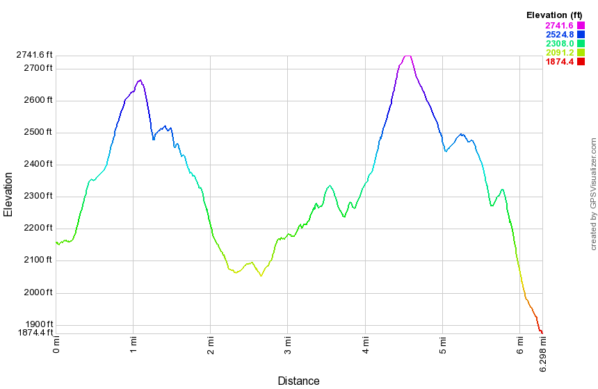 (The image at the left shows the profile of the hike. Remember that all vertical profiles are relative!)
Finger Lakes Trail: Berry Brook Road to Big Pond
| Quick Look | ||||
|---|---|---|---|---|
| Difficulty | Round trip | Total climb | Internet Maps | |
| 9.4 mi. | 3026 ft. | AllTrails | ||
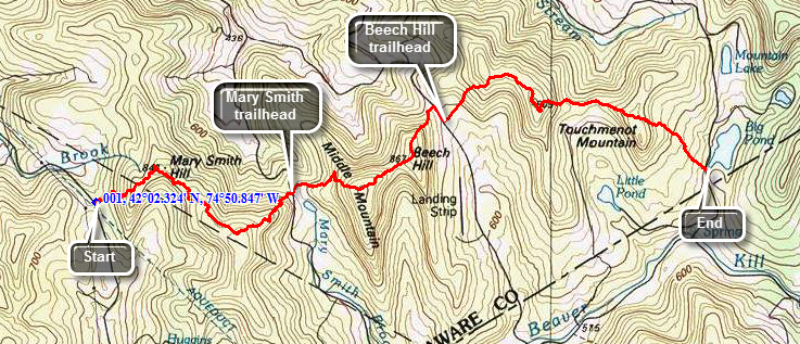 The Finger Lakes Trail is a primitive footpath that starts in Allegheny State Park on the New York - Pennsylvania border and extends 576.5 miles to end in the Catskill Park at the beginning of the Table Peekamoose Trail off the Phoenicia East Branch Trail near the Denning trailhead. There are other side trails which increase the length of the trail system. Four hundred miles of this trail is also part of the Scenic North Country Trail. The Finer Lakes Trail Conference celebrated its 50th Anniversary on June 2, 2012. To commemorate the occasion the Conference set up a series of hikes that would cover the entire length of the trail. Hikes varied in length and difficulty from 4 to 14 miles. The last section is the one described here and is mostly a road walk from The parking area on Black Bear Road (Wild Meadow Road) near Round Pond to the eastern terminus of the trail 1.2 miles from the Denning trailhead.
This hike requires a car spot as it is 9.4 miles one way! From Roscoe, drive north on Route 206 for about 3 miles. Turn right on Berry Brook/Holiday Brook Road and rive another 7.5 miles to the parking area for the Mary Smith Trail on the right. The trail leaves from the kiosk and immediately starts a climb which can be steep at times with a rocky surface. After a mile you will be at the top of Mary Smith Hill. The prickers along this trail can be quite thick in season. A little further along there is a slightly higher hill summit which does not have a name. From the top of this hill at 2.25 miles you will drop almost 700 feet to Mary Smith Hill Road at 3.2 miles. The trail crosses the road and almost immediately start to climb again up to the summit of Middle Mountain. The climb covers 760 feet in about a mile! The trail descends Middle Mountain to a col between Middle Mountain and Beech Hill. After climbing Beech Hill you will descend about 600 feet to a dirt road. Turn right and walk out to Beech Hill Road. Turn right again and walk down the road to the trailhead at 5.8 miles. Turn left and get ready for the climb to the top of Cabot Mountain. From the trailhead it is a total of 1.4 miles and 765 vertical feet to the top of Cabot Mountain. There is nice lookout at the top over the Little Pond Campsites below. The descent down the other side of Cabot Mountain is steep and treacherous in places. There is a lot of loose rock and ice forms easily in the winter. At 7.8 miles you will be at the junction with the Little Pond Loop Trail. Continue straight ahead and begin the climb up Touch-Me-Not Mountain. At 8.3 miles the Finger Lakes Trail turns to the left to go to Big Pond. The next mile is all downhill as you lose 765 feet to the Big Pond parking area.
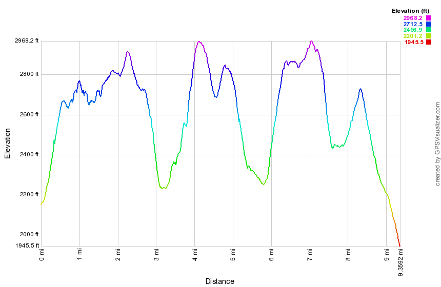 (The image at the left shows the profile of the hike. Remember that all vertical profiles are relative!)
Finger Lakes Trail: Big Pond to Alder Lake
| Quick Look | ||||
|---|---|---|---|---|
| Difficulty | Round trip | Total climb | Internet Maps | |
| 3.3 mi. | 615 ft. | AllTrails | ||
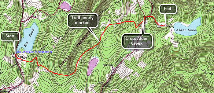 The Finger Lakes Trail is a primitive footpath that starts in Allegheny State Park on the New York - Pennsylvania border and extends 576.5 miles to end in the Catskill Park at the beginning of the Table Peekamoose Trail off the Phoenicia East Branch Trail near the Denning trailhead. There are other side trails which increase the length of the trail system. Four hundred miles of this trail is also part of the Scenic North Country Trail. The Finer Lakes Trail Conference celebrated its 50th Anniversary on June 2, 2012. To commemorate the occasion the Conference set up a series of hikes that would cover the entire length of the trail. Hikes varied in length and difficulty from 4 to 14 miles. The last section is the one described here and is mostly a road walk from The parking area on Black Bear Road (Wild Meadow Road) near Round Pond to the eastern terminus of the trail 1.2 miles from the Denning trailhead.
This hike can easy be done as an out and back from Big Pond since the distance one way is only 3.3 miles. From Livingston Manor, drive north and west toward Roscoe on Old Route 17. Turn right on the Beaverkill Road and drive through Lew Beach to Turnwood. At the sign for the Little Pond StatCcampsiSaturn left on Barkaboom Road. Drive to the parking area for Big Pond on the right side of the road. Walk back down the road to the access road for the upper parking area. Walk up the road and to the right into the parking area. The trail leaves from the back corner of the lot. The hardest part of this hike is finding the markers on the trail. The trail is not used very much and the markers can be hard to see. As you approach the end or the turnaround you will have to cross Alder Creek. This should be an easy task in all but the highest water but there is no bridge. Cross Alder Creek Road and continue straight ahead on the access road to Alder Lake. If you have a car spotted at this end your hike is done. Otherwise, turn around and walk 3.3 miles back to Big Pond.
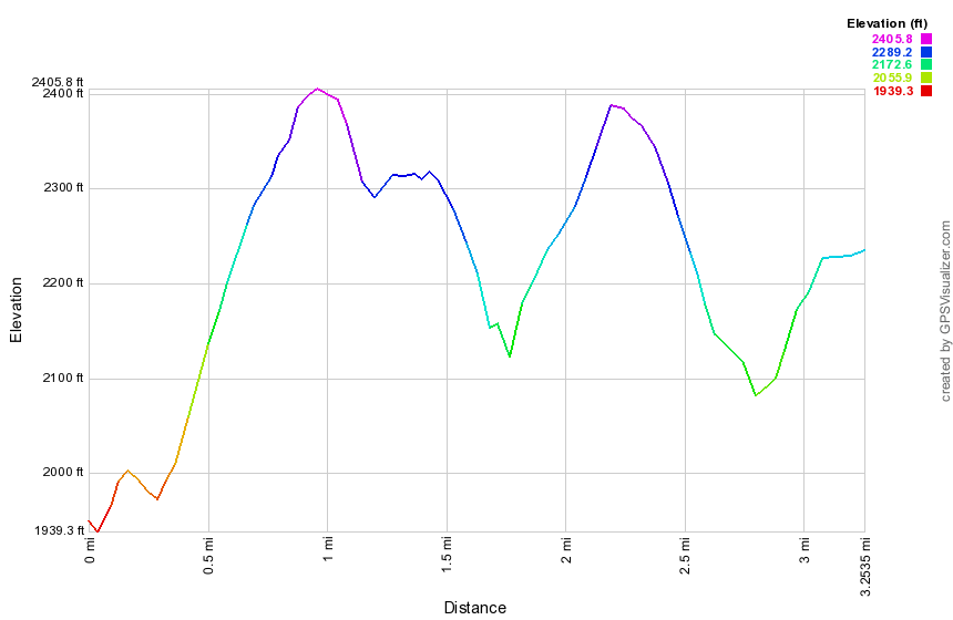 (The image at the left shows the profile of the hike. Remember that all vertical profiles are relative!)
Finger Lakes Trail: Alder Lake to Balsam Lake
| Quick Look | ||||
|---|---|---|---|---|
| Difficulty | Round trip | Total climb | Internet Maps | |
| 7.8 mi. | 3020 ft. | AllTrails | ||
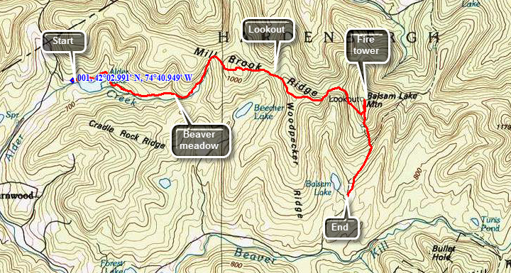
The Finger Lakes Trail is a primitive footpath that starts in Allegheny State Park on the New York - Pennsylvania border and extends 576.5 miles to end in the Catskill Park at the beginning of the Table Peekamoose Trail off the Phoenicia East Branch Trail near the Denning trailhead. There are other side trails which increase the length of the trail system. Four hundred miles of this trail is also part of the Scenic North Country Trail. The Finer Lakes Trail Conference celebrated its 50th Anniversary on June 2, 2012. To commemorate the occasion the Conference set up a series of hikes that would cover the entire length of the trail. Hikes varied in length and difficulty from 4 to 14 miles.
This hike is best done with a car spot as the one-way distance is 7.8 miles with over 3000 feet of ascent. Take the Beaverkill Road from Livingston Manor and drive for about twenty minutes to the Alder Creek Road. Alder Creek Road is a left turn off the Beaverkill Road about two miles after it makes a sharp right turn near the Barkaboom Road that goes to the Little Pond State Campgrounds. Go to the end of Alder Creek Road and turn right into the access road to Alder Lake. Park in the parking lot and walk to the lake. The Coykendall mansion house that stood on the grounds has been removed by New York State as they did not have the money to maintain or restore it. Now only the stone work remains. As you walk toward the lake you may turn stay left to get on the red Alder Lake loop trail. After about .8 miles on this trail the yellow Millbrook Ridge trail breaks off heading east. The trail ascends very gently and after about 1.5 miles on the trail you arrive at the Beaver Meadow lean-to and spring. There once was a large beaver pond here but it is now being reclaimed and forming a meadow. Back on the trail you will pass another pond on your right after which the trail climbs more steeply. After about 1.35 miles you are at the highest point on the ridge (3480 ft). The trail then descends slightly before another ascent to the overlook; a distance of another 1.1 miles. Continue on the main trail heading east and southeast toward Balsam Lake Mountain. At about 5.6 miles you will begin the final climb up to mountain which is on the Catskill 3500 list. At 6 miles you will reach at T. Turn left and walk to the Balsam Lake fire tower at the summit of the mountain. When you have taken pictures of the tower and from the tower head back the way you came and get ready for a steep descent down the mountain. At just under 7 miles you will be at the base of the descent and at another T. Turn right to walk out to the Balsam lake Mountain parking area. If you have spotted a car here, your hike is done. If no car is waiting for you, its just 7.8 miles back to the Alder lake.
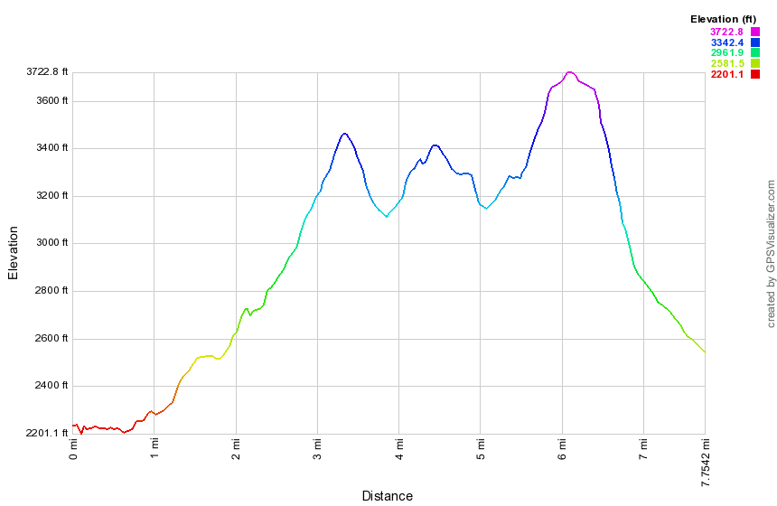 (The image shows the vertical profile of the entire out and back route.)
Finger Lakes Trail: Balsam Lake to Tunis Pond
| Quick Look | ||||
|---|---|---|---|---|
| Difficulty | Round trip | Total climb | Internet Maps | |
| 5.7 mi. | 1030 ft. | AllTrails | ||
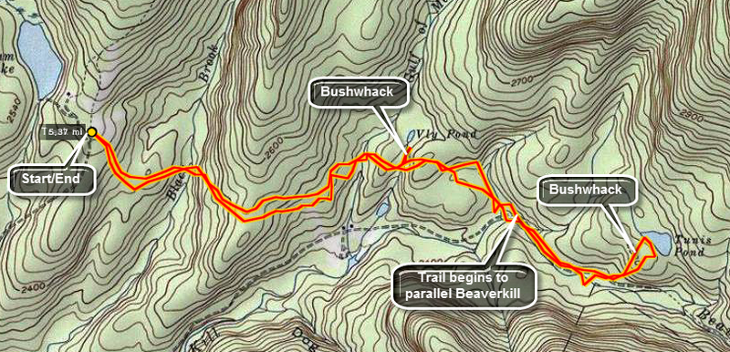 The Finger Lakes Trail is a primitive footpath that starts in Allegheny State Park on the New York - Pennsylvania border and extends 576.5 miles to end in the Catskill Park at the beginning of the Table Peekamoose Trail off the Phoenicia East Branch Trail near the Denning trailhead. There are other side trails which increase the length of the trail system. Four hundred miles of this trail is also part of the Scenic North Country Trail. The Finer Lakes Trail Conference celebrated its 50th Anniversary on June 2, 2012. To commemorate the occasion the Conference set up a series of hikes that would cover the entire length of the trail. Hikes varied in length and difficulty from 4 to 14 miles.
This hike can be done as an out and back hike since the roundtrip distance is 5.7 miles. Park in the Balsam Lake parking area at the end of the Beaverkill Road. The beginning of the trail starts in the upper right corner of the parking area. It passes through a field of ferns and is pretty overgrown but there are some nice views of Balsam Lake Mountain. The register is placed just at the end of the field as the forest begins. Once in the woods, the trail is wide and easy to hike. It descends for about .5 miles to Black Brook and crosses on a bridge. A brief ascent and another descent brings you to the bridge across the Gulf of Mexico Brook at 1.1 miles. A very brief ascent and descent leads to Vly Brook which you can usually step across. At this point Vly Pond is less than .25 miles away. Head out along the creek and until you came to signs of beaver activity. Walk to the edge of the pond where you may be able to walk across the dam if you so desire. Walking around the pond anticlockwise means pushing through some thick balsam and walking over some slick rocks. The reward is a nice view with a few high rocks to stand on. Behind the pond are Balsam Lake and Graham Mountains. Head back out to the main trail and turn left to continue to Tunis Pond. From Vly Pond another ascent and descent brings you to a well-used woods road at 2.0 miles. The trail turns left onto the road and starts to follow the Beaverkill. After walking along the road for about .5 miles, choose a spot to head off into the woods since the road/trail does not lead directly to Tunis Pond. The woods aren't too think and it is only about .25 miles to get to the pond. The walk is uphill since Tunis Pond is said to be the highest named pond in the Catskills! The pond is beautiful and seldom visited. You may walk along the shore in either direction but be prepared for wet, swampy conditions. Toward the lower end of the pond there may be a large beaver house near the middle of the pond. When you are done, head up into the woods and away from the pond. Within only a few minutes and about .3 miles you should be back on the road. Turn right and retrace your route to the car.
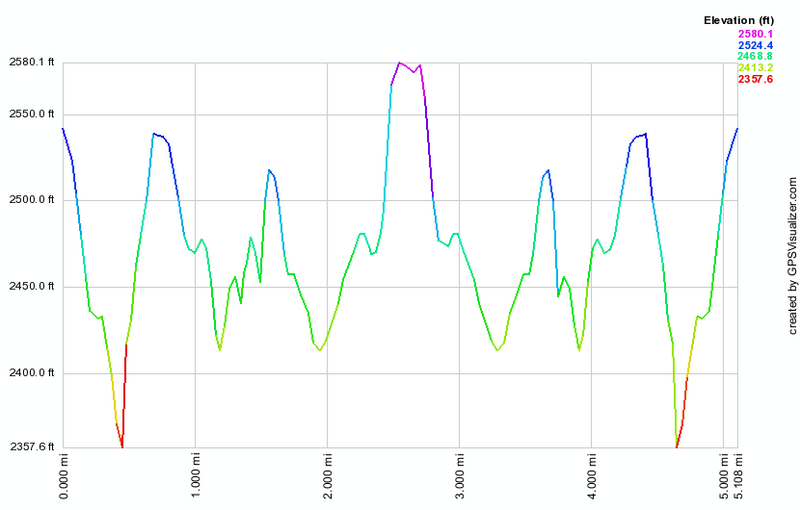 (The image at the left shows the profile of the hike. Remember that all vertical profiles are relative!)
Finger Lakes Trail: Black Bear Road to Tunis Pond
| Quick Look | ||||
|---|---|---|---|---|
| Difficulty | Round trip | Total climb | Internet Maps | |
| 7.1 mi. | 650 ft. | AllTrails | ||
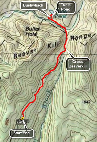 The Finger Lakes Trail is a primitive footpath that starts in Allegheny State Park on the New York - Pennsylvania border and extends 576.5 miles to end in the Catskill Park at the beginning of the Table Peekamoose Trail off the Phoenicia East Branch Trail near the Denning trailhead. There are other side trails which increase the length of the trail system. Four hundred miles of this trail is also part of the Scenic North Country Trail. The Finer Lakes Trail Conference celebrated its 50th Anniversary on June 2, 2012. To commemorate the occasion the Conference set up a series of hikes that would cover the entire length of the trail. Hikes varied in length and difficulty from 4 to 14 miles.
This hike can be done as an out and back hike since the roundtrip distance is 7.1 miles. Park at the end of Black Bear Road (Wild Meadow Road) in the snowplow turnaround ass long as there is no snow! Walk down the road which serves as the beginning of the yellow Neversink Hardenburgh Trail in this area. Walk by the hunting camp and continue on the trail on the other side. The trail can be very wet in places. Cross over a brook and head up a little gaining some elevation. The Fall Brook lean-to is about 1.7 miles into the hike. After passing the lean-to, a swampy area appeared on the right of the trail which leads into a series of beaver ponds and beaver meadows. Doubletop Mountain is in the background. This area is the headwaters of Fall Brook which runs south and the Beaverkill which runs north and west. The trail parallels the Beaverkill for a short distance and then ENDS at the edge of the stream. You should be able to pick up the yellow trail markers ahead. The stream has simply eroded away the trail so you will have to find your own way around by bushwhacking up the bank and then back down to the trail. When you reach the point where the trail crosses the stream, you will find no bridge to safely cross. There is one slightly further downstream but it appears to be on private property. You can cross here by wading, rock hopping or looking for a convenient log bridge. Once across pick up the trail on the other side. It is very narrow in several places as it clings to the bank of the stream and in at least one place all but disappears. Only a short distance from the crossing, the trail opens into a little clearing and a very nice bridge cross the stream! Continue down the woods road until you are near Tunis Pond which is on the right side of the trail. You cannot see the pond from the trail so use you navigational and maps skills to plan a short bushwhack. Head to the right of the trail through the woods and climb a little hill to get to Tunis Pond. The climb can be steep but it is short. When you arrive on the shore of the pond you may want to take pictures of this beautiful and secluded place. Walk along the shore in either direction. When you can tear yourself away, head almost directly south and down the hill which is a direct line to the main trail. Turn left on the main trail and retrace your route to the car.
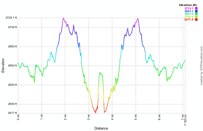 (The image at the left shows the profile of the hike. Remember that all vertical profiles are relative!)
Finger Lakes Trail: Black Bear Road
| Quick Look | ||||
|---|---|---|---|---|
| Difficulty | Round trip | Total climb | Internet Maps | |
| 5.7 mi. | 640 ft. | AllTrails | ||
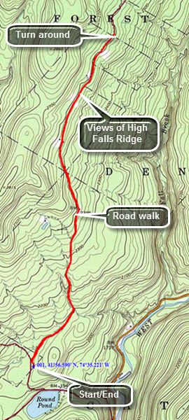 The Finger Lakes Trail is a primitive footpath that starts in Allegheny State Park on the New York - Pennsylvania border and extends 576.5 miles to end in the Catskill Park at the beginning of the Table Peekamoose Trail off the Phoenicia East Branch Trail near the Denning trailhead. There are other side trails which increase the length of the trail system. Four hundred miles of this trail is also part of the Scenic North Country Trail. The Finer Lakes Trail Conference celebrated its 50th Anniversary on June 2, 2012. To commemorate the occasion the Conference set up a series of hikes that would cover the entire length of the trail. Hikes varied in length and difficulty from 4 to 14 miles. The last section is the one described here and is mostly a road walk from The parking area on Black Bear Road (Wild Meadow Road) near Round Pond to the eastern terminus of the trail 1.2 miles from the Denning trailhead.
This hike can easily be done as an out and back as the round trip is only 5.7 miles From Livingston Manor take Debruce Road which changes names from Debruce to Willowemoc to Pole along the 15 mile trip to Round Pond. When Round Pond appears on your right, turn left onto Wild Meadow Road. The road named changed from Black Bear but most people still use the old name. Drive up a short hill and park in the first lot on the right.
The hiking route is rather simple. You will now walk on the road for about 2.8 miles to the end he the "maintained" dirt and gravel road. There is a snowplow turnaround and a "Seasonal Maintenance" sign. To my knowledge there is NEVER any maintenance beyond this point! Turn around and hike back to where you parked.The out part of the hike is all uphill although it is never very steep. Along the way there are some views of the High Falls Ridge on your right. There are also several very nice hunting camps along the road.
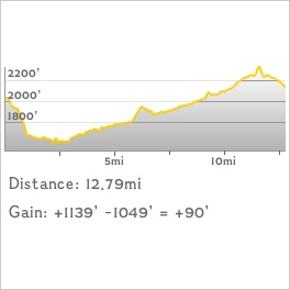 (The image at the left shows the profile of the hike. Remember that all vertical profiles are relative!)
Finger Lakes Trail: Black Bear to Eastern Terminus
| Quick Look | ||||
|---|---|---|---|---|
| Difficulty | Round trip | Total climb | Internet Maps | |
| 12.9 mi. | 1285 ft. | AllTrails | ||
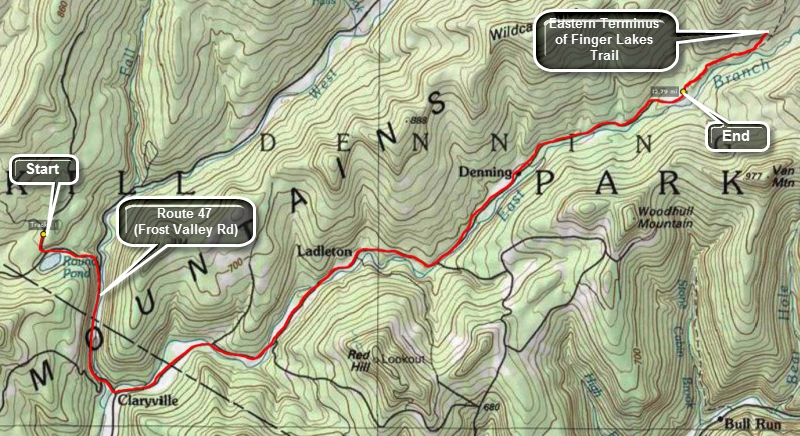 The Finger Lakes Trail is a primitive footpath that starts in Allegheny State Park on the New York - Pennsylvania border and extends 576.5 miles to end in the Catskill Park at the beginning of the Table Peekamoose Trail off the Phoenicia East Branch Trail near the Denning trailhead. There are other side trails which increase the length of the trail system. Four hundred miles of this trail is also part of the Scenic North Country Trail. The Finer Lakes Trail Conference celebrated its 50th Anniversary on June 2, 2012. To commemorate the occasion the Conference set up a series of hikes that would cover the entire length of the trail. Hikes varied in length and difficulty from 4 to 14 miles. The last section is the one described here and is mostly a road walk from The parking area on Black Bear Road (Wild Meadow Road) near Round Pond to the eastern terminus of the trail 1.2 miles from the Denning trailhead.
This hike requires a car spot as it is almost 13 miles one way! From Route 17 (soon to be I86) get off at exit 96 and head away from Livingston Manor on DeBruce Road. Stay on this road as it changes names. In about 15 miles watch for Wild Meadow Road on your left across from Round Pond. This is where you will return to start your hike. At the end of the road turn right on the Frost Valley Road and continue to the end of the road. Turn left on the Claryville Road and drive all the way to the end of the road. From Route 28, turn onto the Frost Valley Road (Route 47) and continue on this road passed Panther and Slide Mountains. Pass the Frost Valley YMCA and continue to the end of the road and turn left on the Claryville Road. Drive all the way to the end of the road. From Route 55, turn north on the Claryville Road in the hamlet of Curry just outside of Grahamsville and drive all the way to the end of the road. Park one or more cars at the Denning trailhead and then drive back through Claryville. Turn right on the Frost Valley Road and drive about 1.5 miles taking a left turn onto Pole Road. The first road to the right across from Round Pond is Wild Meadow Road. Drive up the road and park in the first large parking area on the right. This is where your hike begins.
The hiking route is rather simple. You will now walk on the road back to where you parked at the Denning trailhead! The hike goes quickly since it is a road walk. Once you are through Claryville the road will eventually turn to dirt. There is at least one farm along the way and several picturesque streams. As you near the end of the road there is a slight uphill. At the Denning trailhead, continue passed your car and walk out the woods road at the end of the parking area. Walk about 1.2 miles along this trail to the junction with the trail to Table Mountain. Notice the sign for the eastern terminus of the FLT. Take a picture and return to the Denning trailhead.
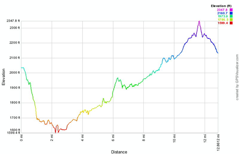 (The image at the left shows the profile of the hike. Remember that all vertical profiles are
relative!)
(The image at the left shows the profile of the hike. Remember that all vertical profiles are
relative!)