
What You Missed
Fall 2024
Fall 2024
![]()
![]()
![]()
![]()
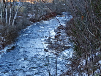
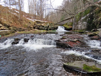
![]() On Saturday, December 14th, I wanted to take Sheena our new puppy for a walk but the temperature at 9:00 AM was only 9 degrees! I went to the ambulance building to hang out and do some work. I retuned home by 2:00 PM and noticed the temperature was 28 degrees. I decided to try taking Sheena on the Parksville Rail Trail from Fox Mountain Road to Parksville. The Parksville Rail Trail is under three miles out and back but carrying a pack and keeping a quick pace helps increase the difficulty. The last time I took Sheena on this hike, I had the feeling that she could have done it again when we got back to the car. I made sure there was a crew around to cover calls. When Cindy returned home, I asked if she would like to go and she said it was too cold! As I was getting dressed at 2:15 PM, I remembered how much Sheila liked to hike this trail and take a swim at the falls. It seemed that Sheena likes hiking as she smells my clothes and then runs to sit by the door! I am looking forward to the time when I can let her off her leash. I got dressed in my Mammut long-sleeved crew top with a long-sleeved baselayer. I put on a pair of RailRiders hiking pants which are expensive but last a long time and have features like deep pockets and a generous cut which I really like. I hoped that these pants would be warm enough once we got moving. I decided to put on my Keen Durand hiking boots which fit well. I added a new pair of Xstance insoles in an effort to find the best support and cushioning for my feet. These insoles have shock absorbing gel pads, TPU arch support, and memory foam cushioning all wrapped in a breathable fabric. The insoles have been hyped by their manufacturer and seemed to be living up to their claims. I put on my Mammut hoody which has plenty of zippers to dump heat but blocks the wind. I made sure I had a warm hat and gloves. I decided not to take any poles as I would have Sheena on her leash. I put my gear in the back of the car and left Livingston Manor at 2:30 PM. I drove out Old Route 17 toward Parksville and pulled into the parking area on the right side of the road just after Fox Mountain Rd. There were no cars parked in the lot when we arrived. I left my phone in the car so I could enjoy the hike. We started out on the trail at 2:40 PM under beautiful blue skies with some sun and a fewwhite clouds. I had put Sheena's harness on her which allows her to pull without choking herself. I attached a light leash to the harness and encouraged Sheena to jump down out of the car. Once of the ground she immediately began to pull me to the trailhead and up the trail.
On Saturday, December 14th, I wanted to take Sheena our new puppy for a walk but the temperature at 9:00 AM was only 9 degrees! I went to the ambulance building to hang out and do some work. I retuned home by 2:00 PM and noticed the temperature was 28 degrees. I decided to try taking Sheena on the Parksville Rail Trail from Fox Mountain Road to Parksville. The Parksville Rail Trail is under three miles out and back but carrying a pack and keeping a quick pace helps increase the difficulty. The last time I took Sheena on this hike, I had the feeling that she could have done it again when we got back to the car. I made sure there was a crew around to cover calls. When Cindy returned home, I asked if she would like to go and she said it was too cold! As I was getting dressed at 2:15 PM, I remembered how much Sheila liked to hike this trail and take a swim at the falls. It seemed that Sheena likes hiking as she smells my clothes and then runs to sit by the door! I am looking forward to the time when I can let her off her leash. I got dressed in my Mammut long-sleeved crew top with a long-sleeved baselayer. I put on a pair of RailRiders hiking pants which are expensive but last a long time and have features like deep pockets and a generous cut which I really like. I hoped that these pants would be warm enough once we got moving. I decided to put on my Keen Durand hiking boots which fit well. I added a new pair of Xstance insoles in an effort to find the best support and cushioning for my feet. These insoles have shock absorbing gel pads, TPU arch support, and memory foam cushioning all wrapped in a breathable fabric. The insoles have been hyped by their manufacturer and seemed to be living up to their claims. I put on my Mammut hoody which has plenty of zippers to dump heat but blocks the wind. I made sure I had a warm hat and gloves. I decided not to take any poles as I would have Sheena on her leash. I put my gear in the back of the car and left Livingston Manor at 2:30 PM. I drove out Old Route 17 toward Parksville and pulled into the parking area on the right side of the road just after Fox Mountain Rd. There were no cars parked in the lot when we arrived. I left my phone in the car so I could enjoy the hike. We started out on the trail at 2:40 PM under beautiful blue skies with some sun and a fewwhite clouds. I had put Sheena's harness on her which allows her to pull without choking herself. I attached a light leash to the harness and encouraged Sheena to jump down out of the car. Once of the ground she immediately began to pull me to the trailhead and up the trail.
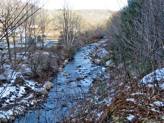
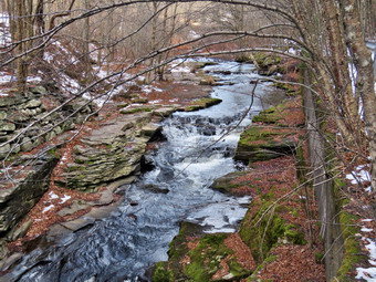
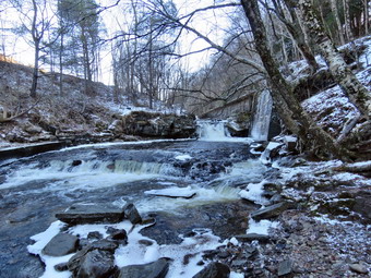 The first part of the trail was frozen and partly covered in a thin layer of snow. Sheena insisted on setting a fast pace and pulling me along. Once we were on the trail and sheltered by the trees it was a little cooler but the trail was still covered in snow. Most of the trail was in the shade and had snow, ice, and some open water and mud. The rail trail runs parallel to the Little Beaverkill and the new section of State Route 17. It follows the route of the O&W railroad and is very flat. Sheena was setting a quick pace and I didn't mind as long as she would listen and slow down and stop pulling when we encountered ice! The water level in the stream was at a much higher level than it had been just two weeks ago due to several days of rain which also melted the snow that had accumulated. The trail had a many small branches that had broke off in the winds that came with the rain storms. I worked to remove them as best I could. There was only one blowdown close to the trailhead that would need tools to remove it. I wondered if we would run into any larger branches or trees down across the trail with the winds that had been blowing lately. The area just before the wooden walkways showed some interesting views as the sun was dipping low so I stopped to take some shots. After that, we walked across the wooden walkways which had some layers of snow and ice. We walked passed several trees that had been cut and cleared. We came to the area of the mudslide that had brought several trees down across the trail and found a OT of ice and some open water to negotiate. Sheena was reluctant to cross but did so with my encouragement. As we walked, we could hear an increase in the noise from the stream and I knew the falls were just ahead. We reached the falls at 3:00 PM and I decided to go to the streambed to take some pictures. Sheena decided she did not want to go so I leashed her to the picnic table. I headed down the path down to the base of the falls which was made difficult by the layer of snow over some ice.
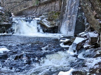 I put my pack down and got out my camera. The water level was higher than it had been in some time and the light level made the falls interesting. I took pictures of the falls using different zooms and angles. The water volume surprised me as it had been so dry for so lomg. I turned around and took some shots downstream. When I was done, I stowed the camera and worked my way back up to the main trail. I got the camera out again and snapped a few more shots from above the falls and a few more upstream. When I was done, we started on the trail toward the Parksville trailhead at 3:15 PM. This time I did not stop upstream of the falls as Sheena was shivering a little from being leashed to the table. We continued toward Parksville with Sheena in the lead pushing the pace. She was trying to do zoomies on a very short leash! I am hoping to be able to let her off her leash to hike sometime soon with an electronic collar to help. Within a few minutes, we were nearing the Parksville end of the trail and Sheena was a little reluctant to continue. She remembered several encounters with barking dogs but there were none this day. We continued and reached the sign at the Parksville end of the rail trail at 3:20 PM. We immediately turned around and started back toward the car. This was the first time we had not seen any dogs at the houses along the trail. Sheena still set a fast pace which would have required me to run so I restrained her a little and gave her commands until she slowed down. We were back at the falls by 3:25 PM and continued the hike without stopping. We continued at a fast pace without stopping and soon were breaking out into the sun and approaching the parking area. We arrived back at the car at 3:45 PM after hiking around 2 miles in 1 hour and 5 minutes including the time to clear the trail and take pictures! There had been no ambulance calls while we were on the trail! I again felt Sheena could haved hike out and back on the trail another time and would have enjoyed it despite the cold.
![]()
![]()
![]()
![]() On Thursday, December 12th I had not hiked for a week because of a high volume of ambulance calls and extremely cold amd wet weather. I hung around the house and covered a call. When I got back at 1:00 PM I decided to take the dog out and walk up the driveway just to get her some exercise. The temperature was only 28 degrees but there was almost no wind so I decided just to wear my uniform and corps jacket. There were mo other EMTs to cover calls so I decided to take my phone with me so that I could respond if needed. At 1:30 PM I put Sheena on her leash and we walked out the door to take a short walk. I had put a harness on Sheena which prevented her from choking herself and added to her effective pull while walking. We headed down the driveway toward the street. I intended to turn around at the end and walk back but Sheena had other ideas. Sheena has gotten used to walking on her leash to the end of the drive. She has even gotten used to waiting for cars to pass by and then crossing when I say "OK". This time she looked both ways and then looked at me and I said "OK" because there were no cars. She readily crossed the street and headed across the field by the church straining against her harness. There wasn't much snow left but it was cold and Sheena showed no reluctance to hike. Sheena led me to the back of the church and turned left to begin the ascent of the steepest hill behind the church. Sheena had no problem walking up the hill except for the fact that she likes to stop and sniff very frequently. I found there was only a thin layer of snow in places but there was some ice. I walked on the side to avoid any ice under the snow. Sheena walked all over the place and had no problem getting a grip with her claws and she was giving me a good pull. The hill is short but gets the circulation pumping and is the steepest and longest climb on the "trail." Not having poles made it more of a challenge for me. We did not stop on the way to the top of the hill and set a fast pace. Sheena is getting bigger every day and her pull on the leash is signficant. Near the top of the hill I could see a pair of hikers. By the time we were at the top, they had entered the trail system. At the top we did not bother to pause because of the overcast. I had planned to hike a loop in the cemetery and this time Sheena did not seem bothered by not turning left onto the trails. We continued straight ahead on the paved road.
On Thursday, December 12th I had not hiked for a week because of a high volume of ambulance calls and extremely cold amd wet weather. I hung around the house and covered a call. When I got back at 1:00 PM I decided to take the dog out and walk up the driveway just to get her some exercise. The temperature was only 28 degrees but there was almost no wind so I decided just to wear my uniform and corps jacket. There were mo other EMTs to cover calls so I decided to take my phone with me so that I could respond if needed. At 1:30 PM I put Sheena on her leash and we walked out the door to take a short walk. I had put a harness on Sheena which prevented her from choking herself and added to her effective pull while walking. We headed down the driveway toward the street. I intended to turn around at the end and walk back but Sheena had other ideas. Sheena has gotten used to walking on her leash to the end of the drive. She has even gotten used to waiting for cars to pass by and then crossing when I say "OK". This time she looked both ways and then looked at me and I said "OK" because there were no cars. She readily crossed the street and headed across the field by the church straining against her harness. There wasn't much snow left but it was cold and Sheena showed no reluctance to hike. Sheena led me to the back of the church and turned left to begin the ascent of the steepest hill behind the church. Sheena had no problem walking up the hill except for the fact that she likes to stop and sniff very frequently. I found there was only a thin layer of snow in places but there was some ice. I walked on the side to avoid any ice under the snow. Sheena walked all over the place and had no problem getting a grip with her claws and she was giving me a good pull. The hill is short but gets the circulation pumping and is the steepest and longest climb on the "trail." Not having poles made it more of a challenge for me. We did not stop on the way to the top of the hill and set a fast pace. Sheena is getting bigger every day and her pull on the leash is signficant. Near the top of the hill I could see a pair of hikers. By the time we were at the top, they had entered the trail system. At the top we did not bother to pause because of the overcast. I had planned to hike a loop in the cemetery and this time Sheena did not seem bothered by not turning left onto the trails. We continued straight ahead on the paved road.
We continued straight ahead under the cover of some gigantic evergreen trees. The trees had prevented too much snow from getting to ground level but there was some ice. We walked down the hill without much trouble turned right on the middle road through the cemetery. My intent was to hike this loop and then return home. At the end of the road, I tried to go straight ahead to the church but Sheena turned right and started back up the hill. I gave in and followed her up the big hill. I again felt stronger the second time up the hill and Sheena was pulling me with her harness. We walked to the top of the hill as I followed behind Sheena who showed no sign of losing any energy. On the downhill, I had to slow Sheena down a bit as she was pulling me off balance. Sheena has remarkably long legs and very sharp nails and seldom slips on any surface. This time as we came to the bottom of the hill, we turned right again to walk the middle road through the cemetery. I watched to see if Sheena was shivering or getting tired but she still looked happy and strong. I had decided we would head back to the house when we had finished this loop twice but Sheena, once again, had other ideas. At the end of the middle road, she turned right and headed up the steepest hill toward the trailhead for the third time. I felt okay but slowed her down a little by saying "With" which keeps her by my side and prevents pulling. At the trailhead, Sheena tried to turn onto the trails but I discouraged her. We walked down the hill beneath the trees and again made the right turn to walk the middle road. This time at the end of tat road we both agreed to continue out to the church. We crossed the field through the snow and walked across the street to the driveway. We arrived back at the house at 2:15 PM after spending 45 minutes hiking. Sheena seemed ready to keep going but I was ready to take a shower and rest.
![]()
![]()
![]()
![]() On Thursday, December 5th I had not hiked for a few days because of a high volume of ambulance calls and extremely cold weather. When I woke up, I found that several more inches of snow had fallen, the temperature was 22 degrees and the wind was blowing. At 8:00 AM I went out to shovel the walks and make sure the snow was cleaned off my car in case I had to respond on a call. At 9:00 AM I came inside and decided we would go across the street to hike a few cemetery loops. Sheena had done all the last time we had hiked in the snow but the temperature was only 28 degrees with a stiff breeze. There were mo other EMTs to cover calls so I decided to take my phone with me so that I could respond if needed. I started to get ready to hike at 9:15 AM with the temperature at 26 degrees on the back porch and a few snow showers. I got dressed in my Mammut long-sleeved crew top with a long-sleeved baselayer. I put on a pair of RailRiders hiking pants which are expensive but last a long time and have features like deep pockets and a generous cut which I really like. I made a note to bring my winter clothing down from the attic! I had not yet brought out my winter boots so I decided to put on my Keen Durand hiking boots which fit well. I added a new pair of Xstance insoles in an effort to find the best support and cushioning for my feet. These insoles have shock absorbing gel pads, TPU arch support, and memory foam cushioning all wrapped in a breathable fabric. The insoles have been hyped by their manufacturer and seemed to be living up to their claims. I did put on my Mammut hoody as I felt that it would keep me warm enough but the pitzips would allow me to dump enough heat if I was too warm. I put on a warm hat and gloves. I decided not to take any poles as the walk would be short and I would be holding Sheena's leash. At 9:30 AM I put Sheena on her leash and we walked out the door to start the hike. I had put a harness on Sheena which prevented her from choking herself and added to her effective pull on the trails. We headed down the driveway and toward the street. Sheena has gotten used to walking on her leash to the end of the drive. She has even gotten used to waiting for cars to pass by and then crossing when I say "OK". This time she look both ways and then looked at me and I said "OK" because there were no cars. She readily crossed the street and headed across the field by the church straining against her harness. The snow was up to her belly which does not have much insulation but that did not bother her at all. The snow was deep enough to wear snowshoes but not deep enough to really "require" wearing them. We walked to the back of the church and began the ascent of the steepest hill behind the church. Sheena had no problem walking up the hill except for the fact that she likes to stop and sniff very frequently. I found there was more snow than the last time we had hiked here. I walked on the side to avoid any ice under the snow. Sheena walked all over the place and had no problem getting a grip with her claws and giving me a good pull. The hill is short but gets the circulation pumping and is the steepest and longest climb on the "trail." Not having poles made it more of a challenge for me. We did not stop on the way to the top of the hill and set a fast pace. Sheena is getting bigger every day and her pull on the leash is signficant. At the top we did not bother to pause because of the overcast and the snow that was still falling. Sheena did not seem to be bothered at all by the snow on the ground or the snow falling from the sky. I had planned to hike loops in the cemetery and this time Sheena did not see, bothered by not turning left onto the trails. We continued straight ahead on the paved road.
On Thursday, December 5th I had not hiked for a few days because of a high volume of ambulance calls and extremely cold weather. When I woke up, I found that several more inches of snow had fallen, the temperature was 22 degrees and the wind was blowing. At 8:00 AM I went out to shovel the walks and make sure the snow was cleaned off my car in case I had to respond on a call. At 9:00 AM I came inside and decided we would go across the street to hike a few cemetery loops. Sheena had done all the last time we had hiked in the snow but the temperature was only 28 degrees with a stiff breeze. There were mo other EMTs to cover calls so I decided to take my phone with me so that I could respond if needed. I started to get ready to hike at 9:15 AM with the temperature at 26 degrees on the back porch and a few snow showers. I got dressed in my Mammut long-sleeved crew top with a long-sleeved baselayer. I put on a pair of RailRiders hiking pants which are expensive but last a long time and have features like deep pockets and a generous cut which I really like. I made a note to bring my winter clothing down from the attic! I had not yet brought out my winter boots so I decided to put on my Keen Durand hiking boots which fit well. I added a new pair of Xstance insoles in an effort to find the best support and cushioning for my feet. These insoles have shock absorbing gel pads, TPU arch support, and memory foam cushioning all wrapped in a breathable fabric. The insoles have been hyped by their manufacturer and seemed to be living up to their claims. I did put on my Mammut hoody as I felt that it would keep me warm enough but the pitzips would allow me to dump enough heat if I was too warm. I put on a warm hat and gloves. I decided not to take any poles as the walk would be short and I would be holding Sheena's leash. At 9:30 AM I put Sheena on her leash and we walked out the door to start the hike. I had put a harness on Sheena which prevented her from choking herself and added to her effective pull on the trails. We headed down the driveway and toward the street. Sheena has gotten used to walking on her leash to the end of the drive. She has even gotten used to waiting for cars to pass by and then crossing when I say "OK". This time she look both ways and then looked at me and I said "OK" because there were no cars. She readily crossed the street and headed across the field by the church straining against her harness. The snow was up to her belly which does not have much insulation but that did not bother her at all. The snow was deep enough to wear snowshoes but not deep enough to really "require" wearing them. We walked to the back of the church and began the ascent of the steepest hill behind the church. Sheena had no problem walking up the hill except for the fact that she likes to stop and sniff very frequently. I found there was more snow than the last time we had hiked here. I walked on the side to avoid any ice under the snow. Sheena walked all over the place and had no problem getting a grip with her claws and giving me a good pull. The hill is short but gets the circulation pumping and is the steepest and longest climb on the "trail." Not having poles made it more of a challenge for me. We did not stop on the way to the top of the hill and set a fast pace. Sheena is getting bigger every day and her pull on the leash is signficant. At the top we did not bother to pause because of the overcast and the snow that was still falling. Sheena did not seem to be bothered at all by the snow on the ground or the snow falling from the sky. I had planned to hike loops in the cemetery and this time Sheena did not see, bothered by not turning left onto the trails. We continued straight ahead on the paved road.
We continued straight ahead under the cover of some gigantic evergreen trees. The trees had prevented too much snow from getting to ground level but there was some ice. We walked down the hill without much trouble turned right on the middle road through the cemetery. My intent was to hike two of these loops and then return home. At the end of the road, we turned right to start the walk up the big hill. I again felt stronger the second time up the hill and Sheena was pulling me with her harness. We walked to the top of the hill as I followed behind Sheena who showed no sign of losing any energy. On the downhill, I had to slow Sheena down a bit as she was pulling me off balance. Sheena has remarkably long legs and very sharp nails and seldom slips on any surface. This time as we came to the bottom of the hill, we turned right again to walk the middle road through the cemetery. I watched to see if Sheena was shivering or getting tired but she still looked happy and strong. I had decided we would head back to the house when we had finished this shorter loop twice but Sheena had other ideas. At the end of the middle road, she turned right and headed up the steepest hill toward the trailhead. I felt okay but slowed her down a little by saying "With" which keepers her by my side and prevents pulling. At the trailhead, Sheena tried to turn onto the trails but I discouraged her. We walked down the hill beneath the trees and again made the right turn to walk the middle road. This time at the end of tat road we both agreed to continue out to the church. We crossed the field through the snow and walked across the street to the driveway. We arrived back at the house at 10:30 AM after spending an hour hiking. Sheena seemed ready to keep going but I was ready to take a shower and rest.
![]()
![]()
![]()
![]() On Sunday, December 1st I had not hiked for almost a week because of a high volume of ambulance calls and extremely cold weather. By the late afternoon I had already covered two calls and just wanted to get out of the house. There were other EMTs to cover calls so I decided to get out for a hike on Round Top with Sheena. She is a Feist-Cur cross which are actual types of dogs used on farms and for hunting in the south. She had shown that hiking in the snow did not bother her so I thought I would take her with me. I started to get ready to hike at 2:45 PM with the temperature at 26 degrees on the back porch and a few snow showers. I got dressed in my Mammut long-sleeved crew top with a long-sleeved baselayer. I put on a pair of RailRiders hiking pants which are expensive but last a long time and have features like deep pockets and a generous cut which I really like. I had not yet brought out my winter boots so I decided to put on my Keen Durand hiking boots which fit well. I added a new pair of Xstance insoles in an effort to find the best support and cushioning for my feet. These insoles have shock absorbing gel pads, TPU arch support, and memory foam cushioning all wrapped in a breathable fabric. The insoles have been hyped by their manufacturer and seemed to be living up to their claims. I did put on my Mammut hoody as I felt that it would keep me warm enough but the pitzips would allow me to dump enough heat if I was too warm. I decided not to take any poles as the walk would be short and I would be holding Sheena's leash. At 3:10 PM I put Sheena on her leash and we walked out the door to start the hike. I had put a harness on Sheena which prevented her from choking herself and added to her effective pull on the trails. We headed down the driveway and toward the street. Sheena has gotten used to walking on her leash to the end of the drive. She has even gotten used to waiting for cars to pass by and then crossing when I say "OK". This time she look both ways and then looked at me and I said "OK" because there were no cars. She readily crossed the street and headed across the field by the church straining against her harness. The snow was up to her belly which does not have much insulation but that did not bother her at all. I knew I probably should have worn snowshoes or at least spikes for some grip up and down the hills. We walked to the back of the church and began the ascent of the steepest hill behind the church. Sheena had no problem walking up the hill except for the fact that she likes to stop and sniff very frequently. I found less snow on the hill than I thought but there was some ice. The hill is short but gets the circulation pumping and is the steepest and longest climb on the "trail." Not having poles made it more of a challenge for me. We did not stop on the way to the top of the hill and set a fast pace. Sheena is getting bigger every day and her pull on the leash is signficant. At the top we did not bother to pause because of the overcast. Sheena did not seem to be bothered at all by the snow on the ground or the snow falling from the sky. I looked at the trail and saw quite a bit of snow. I decided we would just do some laps of the cemetery hills. I continued straight ahead on the paved road which did not please Sheena one bit. She really wanted to turn onto the trail but I prevailed.
On Sunday, December 1st I had not hiked for almost a week because of a high volume of ambulance calls and extremely cold weather. By the late afternoon I had already covered two calls and just wanted to get out of the house. There were other EMTs to cover calls so I decided to get out for a hike on Round Top with Sheena. She is a Feist-Cur cross which are actual types of dogs used on farms and for hunting in the south. She had shown that hiking in the snow did not bother her so I thought I would take her with me. I started to get ready to hike at 2:45 PM with the temperature at 26 degrees on the back porch and a few snow showers. I got dressed in my Mammut long-sleeved crew top with a long-sleeved baselayer. I put on a pair of RailRiders hiking pants which are expensive but last a long time and have features like deep pockets and a generous cut which I really like. I had not yet brought out my winter boots so I decided to put on my Keen Durand hiking boots which fit well. I added a new pair of Xstance insoles in an effort to find the best support and cushioning for my feet. These insoles have shock absorbing gel pads, TPU arch support, and memory foam cushioning all wrapped in a breathable fabric. The insoles have been hyped by their manufacturer and seemed to be living up to their claims. I did put on my Mammut hoody as I felt that it would keep me warm enough but the pitzips would allow me to dump enough heat if I was too warm. I decided not to take any poles as the walk would be short and I would be holding Sheena's leash. At 3:10 PM I put Sheena on her leash and we walked out the door to start the hike. I had put a harness on Sheena which prevented her from choking herself and added to her effective pull on the trails. We headed down the driveway and toward the street. Sheena has gotten used to walking on her leash to the end of the drive. She has even gotten used to waiting for cars to pass by and then crossing when I say "OK". This time she look both ways and then looked at me and I said "OK" because there were no cars. She readily crossed the street and headed across the field by the church straining against her harness. The snow was up to her belly which does not have much insulation but that did not bother her at all. I knew I probably should have worn snowshoes or at least spikes for some grip up and down the hills. We walked to the back of the church and began the ascent of the steepest hill behind the church. Sheena had no problem walking up the hill except for the fact that she likes to stop and sniff very frequently. I found less snow on the hill than I thought but there was some ice. The hill is short but gets the circulation pumping and is the steepest and longest climb on the "trail." Not having poles made it more of a challenge for me. We did not stop on the way to the top of the hill and set a fast pace. Sheena is getting bigger every day and her pull on the leash is signficant. At the top we did not bother to pause because of the overcast. Sheena did not seem to be bothered at all by the snow on the ground or the snow falling from the sky. I looked at the trail and saw quite a bit of snow. I decided we would just do some laps of the cemetery hills. I continued straight ahead on the paved road which did not please Sheena one bit. She really wanted to turn onto the trail but I prevailed.
We continued straight ahead under the cover of some gigantic evergreen trees. The trees had prevented too much snow from getting to ground level but there was some ice. We walked down the hill without much trouble and continued straight ahead to do a big loop. I was hoping the small dog that is usually loose would be inside and we did not see him. We continued out toward the church on Orchard Street. We turned right and continued toward the church in Orchard Street. We turned right to walk behind the church and then right again to start up the big hill. For some reason I felt stronger the second time up the hill and Sheena was pulling me on her harness. We rushed to the top of the hill with me panting a little bit. On the downhill, I had to slow Sheena down a bit as she was pulling me off balance. Sheena has remarkably long legs and very sharp nails and seldom slips on any surface. This time as we came to the bottom of the steep hill, we turned right to walk the middle road through the cemetery. I watch to see if Sheena was shivering but she still looked happy and strong. I had decided we would head back to the house when we had finished this shorter loop but Sheena had other ideas. At the end of the middle road, she turned right and headed up the steepest hill toward the trailhead. I felt okay but slowed her down a little by saying "With" which keepers her by my side and prevents pulling. At the trailhead, Sheena tried to turn onto the trails but I discouraged her. We walked down the hill beneath the tress and again made the right turn to walk the middle road. This time at the end of tat road we both agreed to continue out to the church. We crossed the field through the snow and walked across the street to the driveway. We arrived back at the house at 4:00 PM after spending 50 minutes hiking. Sheena seemed ready to keep going but I was ready to take a shower and rest.
![]()
![]()
![]()
![]()
![]() On Monday, November 25th, I wanted to take Sheena our new puppy for a walk on the Parksville Rail Trail from Fox Mountain Road. The Parksville Rail Trail is under three miles out and back but carrying a pack and keeping a quick pace helps increase the difficulty. The last time I took Sheena on this hike, I had the feeling that she could have done it again when we got back to the car. A soften happens, my ability to make time for a hike depends ambulance calls and ambulance coverage. We did two overnight calls which took a little more time than usual and wiped out my ability to get any sleep. I though I could get by but by 9:00 AM I realized it was hopeless and I went upstairs to sleep. I awoke a noon and felt pretty good and ready for a hike. I wasn't sure who was around to cover calls but decided I needed to get away if only to Parksville. I asked Cindy if she would like to go and she agreed as the trail is flat which is her preferred terrain. As I was getting dressed at 1:00 PM, I remembered how much Sheila liked to hike this trail and take a swim at the falls. It seemed that Sheena likes hiking as she smells my clothes and then runs to sit by the door! I am looking forward to the time when I can let her off her leash. I found that since Sheila passed away I still feel she is with me on hikes and I have vivid memories of her on each trail. It was 48 degrees on the back porch but there was no breeze blowing. I got dressed in my Mammut long-sleeved crew top with a long-sleeved baselayer. I put on a pair of RailRiders hiking pants which are expensive but last a long time and have features like deep pockets and a generous cut which I really like. I decided to put on my Keen Durand hiking boots which fit well. I added a new pair of Xstance insoles in an effort to find the best support and cushioning for my feet. These insoles have shock absorbing gel pads, TPU arch support, and memory foam cushioning all wrapped in a breathable fabric. The insoles have been hyped by their manufacturer and seemed to be living up to their claims. I put on my Mammut hoody which has plenty of zippers to dump heat but blocks the wind. I decided not to take any poles as I would have Sheena on her leash. I put our gear in the back of the car and left Livingston Manor at 1:10 PM. I drove out Old Route 17 toward Parksville and pulled into the parking area on the right side of the road just after Fox Mountain Rd. There were no cars parked in the lot when we arrived. I left my phone in the car so I could enjoy the hike. We started out on the trail at 1:25 PM under beautiful blue skies with plenty of sun and puffy white clouds. I had put Sheena's harness on her which allows her to pull without choking herself. I attached a light leash to the harness and encouraged Sheena to jump down out of the car. Once of the ground she immediately began to pull me to the trailhead and up the trail.
On Monday, November 25th, I wanted to take Sheena our new puppy for a walk on the Parksville Rail Trail from Fox Mountain Road. The Parksville Rail Trail is under three miles out and back but carrying a pack and keeping a quick pace helps increase the difficulty. The last time I took Sheena on this hike, I had the feeling that she could have done it again when we got back to the car. A soften happens, my ability to make time for a hike depends ambulance calls and ambulance coverage. We did two overnight calls which took a little more time than usual and wiped out my ability to get any sleep. I though I could get by but by 9:00 AM I realized it was hopeless and I went upstairs to sleep. I awoke a noon and felt pretty good and ready for a hike. I wasn't sure who was around to cover calls but decided I needed to get away if only to Parksville. I asked Cindy if she would like to go and she agreed as the trail is flat which is her preferred terrain. As I was getting dressed at 1:00 PM, I remembered how much Sheila liked to hike this trail and take a swim at the falls. It seemed that Sheena likes hiking as she smells my clothes and then runs to sit by the door! I am looking forward to the time when I can let her off her leash. I found that since Sheila passed away I still feel she is with me on hikes and I have vivid memories of her on each trail. It was 48 degrees on the back porch but there was no breeze blowing. I got dressed in my Mammut long-sleeved crew top with a long-sleeved baselayer. I put on a pair of RailRiders hiking pants which are expensive but last a long time and have features like deep pockets and a generous cut which I really like. I decided to put on my Keen Durand hiking boots which fit well. I added a new pair of Xstance insoles in an effort to find the best support and cushioning for my feet. These insoles have shock absorbing gel pads, TPU arch support, and memory foam cushioning all wrapped in a breathable fabric. The insoles have been hyped by their manufacturer and seemed to be living up to their claims. I put on my Mammut hoody which has plenty of zippers to dump heat but blocks the wind. I decided not to take any poles as I would have Sheena on her leash. I put our gear in the back of the car and left Livingston Manor at 1:10 PM. I drove out Old Route 17 toward Parksville and pulled into the parking area on the right side of the road just after Fox Mountain Rd. There were no cars parked in the lot when we arrived. I left my phone in the car so I could enjoy the hike. We started out on the trail at 1:25 PM under beautiful blue skies with plenty of sun and puffy white clouds. I had put Sheena's harness on her which allows her to pull without choking herself. I attached a light leash to the harness and encouraged Sheena to jump down out of the car. Once of the ground she immediately began to pull me to the trailhead and up the trail.
 The first part of the trail was damp from the recent rain and snow melt and there was almost no snow left on the trail. Once we were on the trail and sheltered by the trees it was a little cooler and the trail was damp in some spots and wet in others. Where the trail was in the shade, there was still a layer of snow but the areas exposed to the sun were bare. The rail trail runs parallel to the Little Beaverkill and the new section of State Route 17. It follows the route of the O&W railroad and is very flat. Sheena was setting a quick pace but I did not want to race out and back as fast as possible. The water level in the stream was at a higher level than it had been just two weeks ago despite weeks without any rain. The trail had a many small branches broke off in the trail and Cindy and I worked to remove them. Not far into the trail there was one larger branch blocking half the trail and would require a saw to remove it. I wondered if we would run into any larger branches or trees down across the trail with the winds that had been blowing lately. The area just before the wooden walkways showed some interesting views so I stopped to take some shots. After that, we walked across the wooden walkways which had some layers of mud and some snow and ice. We walked passed several trees that had been cut and cleared. As we came to the area of the mudslide that had brought several trees down across the trail, I looked up to see a lone male hiker coming toward us with his small dog on a leash. We passed by each other with a short "Hello". There was a little water and a thin layer of mud so Sheena was reluctant to cross but did so with my encouragement. As we walked, we could hear an increase in the noise from the stream and I knew the falls were just ahead. We reached the falls and decided to go to the streambed to take some pictures without Sheena. I Handed her leash to Cindy and headed down the path down to the base of the falls. Cindy parked herself on the picnic bench to wait with Sheena for my return. Getting to the botttom of the path was not easy as some snow, ice, and wet leaves made the descent slippery.
 I put my pack down and got out my camera. The water level was higher than it had been in some time and the light level made the falls interesting. I took pictures of the falls using different zooms and angles. I turned around and took some shots downstream. When I was done, I stowed the camera and worked my way back up to the main trail. I got the camera out again and snapped a few more shots from above the falls and a few more upstream. When I was done, we started on the trail toward the Parksville trailhead. The last time we were on the trail. the water level was so low that I was able to walk along the edge of the stream to the brink of the falls. This time I did not stop and we continued toward Parksville with Sheena in the lead pushing the pace. She was trying to do zoomies on a very short leash! I am hoping to be able to let her off her leash to hike sometime soon with an electronic collar to help. Within a few minutes, we were nearing the Parksville end o the trail and Sheena was reluctant to continue. Someone was playing loud music and Sheena remembered a rather large dog along the way. We continued and reached the sign at the Parksville end of the rail trail. At 2:25 PM. This was much longer than our last hike but included time to remove brnaches and visit the falls. We immediately turned around and started back toward the car. This was the first time we had not seen any dogs at the houses along the trail. SheEna still set a fast pace which would have required us to run so I restrained her a little and she slowed down. We were back at the falls in 6 minutes and we continued the hike without stopping. We met the man with his dog and passed each other quickly. We continued at a fast pace without stopping and soon were breaking out into the sun and approaching the parking area. We arrived back at the car at 2:55 PM after hiking around 2 miles in 1 hour and 30 minutes including the time to clear the trail and take pictures! There had been no ambulance calls while we were on the trail! Cindy and I both felt Sheena could haved hike out and back on the trail another time and would have enjoyed it.
![]()
![]()
![]()
![]() On Thursday, November 21st I had not hiked for almost a week because of other commitments including a high volume of ambulance calls. For the two previous days I had started across the street to hike with Sheena on Round Top and had to turn back to cover calls. It was raining on Thursday so I had not planned to hike. By the late afternoon I had already covered two calls and just wanted to get out of the house. Despite the rain I decided to get out for a hike on Round Top with Sheena. She is a Feist-Cur cross which are actual types of dogs used on farms and for hunting in the south. I wasn't sure how she would like hiking in the cold rain but I wanted to try. I started to get ready to hike at 3:45 PM with the temperature at 46 degrees on the back porch and a light drizzle. I got dressed in my White Sierra long-sleeved crew top with a short-sleeved baselayer as my other clothing was in the wash. I put on a pair of RailRiders hiking pants which are expensive but last a long time and have features like deep pockets and a generous cut which I really like. I decided to put on my Keen Durand hiking boots which fit well. I added a new pair of Xstance insoles in an effort to find the best support and cushioning for my feet. These insoles have shock absorbing gel pads, TPU arch support, and memory foam cushioning all wrapped in a breathable fabric. The insoles have been hyped by their manufacturer and seemed to be living up to their claims. I did put on my Mammut hoody as I felt that it would keep me warm enough but the pitzips would allow me to dump enough heat if I was too warm. I decided not to take any poles as the walk would be short and I would be holding Sheena's leash. At 4:10 PM I put Sheena on her leash and we walked out the door to start the hike. I had put a harness on Sheena which prevented her from choking herself and added to her effective pull on the trails. We headed down the driveway and toward the street. Sheena has gotten used to walking on her leash to the end of the drive. She has gotten used to waiting for cars to pass by and then crossing when I say "OK". This time she look both ways and then looked at me and I said "OK" because there were no cars. She readily crossed the street and headed across the field by the church straining against her harness. We walked to the back of the church and began the ascent of the steepest hill behind the church. Sheena had no problem walking up the hill except for the fact that she likes to stop and sniff very frequently. The hill is short but gets the circulation pumping and is the steepest and longest climb on the "trail." Not having poles made it more of a challenge for me. We did not stop on the way to the top of the hill and set a fast pace. Sheena is getting bigger every day and her pull on the leash is signficant. At the top we did not bother to paused because of the overcast and the drizzle. Sheena did not seem to be bothered by the rain or the cooler temperatures. She was eager to enter the woods on the trail and hopped right up the steps. The trail was damp with lots of leaves making it slipperier than it had been in some time.
On Thursday, November 21st I had not hiked for almost a week because of other commitments including a high volume of ambulance calls. For the two previous days I had started across the street to hike with Sheena on Round Top and had to turn back to cover calls. It was raining on Thursday so I had not planned to hike. By the late afternoon I had already covered two calls and just wanted to get out of the house. Despite the rain I decided to get out for a hike on Round Top with Sheena. She is a Feist-Cur cross which are actual types of dogs used on farms and for hunting in the south. I wasn't sure how she would like hiking in the cold rain but I wanted to try. I started to get ready to hike at 3:45 PM with the temperature at 46 degrees on the back porch and a light drizzle. I got dressed in my White Sierra long-sleeved crew top with a short-sleeved baselayer as my other clothing was in the wash. I put on a pair of RailRiders hiking pants which are expensive but last a long time and have features like deep pockets and a generous cut which I really like. I decided to put on my Keen Durand hiking boots which fit well. I added a new pair of Xstance insoles in an effort to find the best support and cushioning for my feet. These insoles have shock absorbing gel pads, TPU arch support, and memory foam cushioning all wrapped in a breathable fabric. The insoles have been hyped by their manufacturer and seemed to be living up to their claims. I did put on my Mammut hoody as I felt that it would keep me warm enough but the pitzips would allow me to dump enough heat if I was too warm. I decided not to take any poles as the walk would be short and I would be holding Sheena's leash. At 4:10 PM I put Sheena on her leash and we walked out the door to start the hike. I had put a harness on Sheena which prevented her from choking herself and added to her effective pull on the trails. We headed down the driveway and toward the street. Sheena has gotten used to walking on her leash to the end of the drive. She has gotten used to waiting for cars to pass by and then crossing when I say "OK". This time she look both ways and then looked at me and I said "OK" because there were no cars. She readily crossed the street and headed across the field by the church straining against her harness. We walked to the back of the church and began the ascent of the steepest hill behind the church. Sheena had no problem walking up the hill except for the fact that she likes to stop and sniff very frequently. The hill is short but gets the circulation pumping and is the steepest and longest climb on the "trail." Not having poles made it more of a challenge for me. We did not stop on the way to the top of the hill and set a fast pace. Sheena is getting bigger every day and her pull on the leash is signficant. At the top we did not bother to paused because of the overcast and the drizzle. Sheena did not seem to be bothered by the rain or the cooler temperatures. She was eager to enter the woods on the trail and hopped right up the steps. The trail was damp with lots of leaves making it slipperier than it had been in some time.
We started on the trail with Sheena setting a good pace. At the first trail junction, we continued straight up the hill with Sheena leading the way on her leash. Sheena was full of energy and wanted to play in the leaves, climb every rock, and slide down the bank. I encouraged her to concentrate on hiking and we progressed up the hill. When we reached the top of the hill, we followed the yellow trail as it turned right. The trails were covered with multicolored leaves but many were just brown and damp from the rain. There were almost no leaves on the trees. We walked uphill through the field of ferns that was almost completely brown with the nighttime temperatures in the high 20's. When we reached the "sitting rock", Sheena ignored it and continued to walk along the trail. We continued on the yellow trail up a small hill to the junction with the blue trail to the summit. I decided that we would do a loop rather than a figure 8 so we continued straight up the hill on the blue trail. At the switchback we turned right and walked out the trail until we turned 180 degrees and headed back. The trail sidehills some and the slippery and damp leaves made it a little more difficult than when dry. We turned almost 180 degrees and walked the switchback to the main trail. We turned right and walked up and over the summit of Round Top. As we started down the other side Sheena wanted to go as fast as she could bur responded to my command of "Walk easy!" When we came to the trail junction, we continued straight ahead on the yellow trail walking downhill to the woods road. We turned slightly right on the woods road and headed downhill toward the first trail junction. I let Sheena have a little more leeway and did a little jogging to keep up with her. By the time we reached the trail junction, it was dark and getting darker. It was also getting colder but I decided we would extend our hike by doing a small loop.
We turned around and started back up the woods road with Sheena pushing the pace. At the end of the woods road we turned left on the yellow trail and headed up to the first junction with the blue trail. We turned left on the yellow trail at the junction and walked along the base of Round Top to the next junction with the blue trail. Since it was getting dark and we were getting wetter, we turned left and again walked along the base of Round Top. At the next trail junction, we turned left and headed toward the lookout. We continued downhill on the yellow trail and Sheena again bypassed the "Sitting Rocks". We walked on the yellow trail down to the viewpoint amd continued to follow the trail as it turned left. Sheena still had tons of energy left and it was hard to stop her from trying to do zoomies, growl, and bite her leash. We started to descend the trail which was covered in a heavy layer of dead and damp leaves. Sheena showed she still had a lot of energy left as she was biting the leash, growling, and skidding downhill through the leaves. I decided to let her have her fun until we got to the first trail junction. We walked straight out to the trailhead and turned right to walk down the cemetery hill to the church parking lot. Sheena kept looking for the dog that sometimes comes over from one of the houses to annoy us but there was no dog this time. At the bottom of the hill, we walked behind the church and across the field by the church with Sheena leading the way. She walked across the road after we looked both ways. We were back at the house by 4:55 PM. That was a total of 45 minutes for a little 2 miles of hiking. Sheena drank a lot of water and ate supper before curling up on the couch.
![]()
![]()
![]()
![]() On Saturday, November 16th I planned to get out for a hike on Round Top with my new dog Sheena. She is a Feist-Cur cross which are actual types of dogs used on farms and for hunting in the south. She probably won't get to be more than 30 pounds which makes Cindy happy although I would have preferred a larger dog. She was born the day after Sheila died. I had an morning ambulance call which turned out to be rather ordinary. When I came home, I got some work dome around the house and waited for ambulance calls. No ambulance calls came so I started to get ready to hike at 2:00 PM with the temperature at 48 degrees on the back porch. I got dressed in my Mammut long-sleeved crew top without a baselayer thinking about the last time I wore another layer and came back drenched in sweat. I put on a pair of RailRiders hiking pants which are expensive but last a long time and have features like deep pockets and a generous cut which I really like. I decided to put on my Keen Durand hiking boots which fit well. I added a new pair of Xstance insoles in an effort to find the best support and cushioning for my feet. These insoles have shock absorbing gel pads, TPU arch support, and memory foam cushioning all wrapped in a breathable fabric. The insoles have been hyped by their manufacturer and seemed to be living up to their claims. I did put on my Mammut hoody as I felt that the pitzips would allow me to dump enough heat if I was too warm. I decided not to take any poles as the walk would be short and I would be holding Sheena's leash. At 2:15 PM I put Sheena on her leash and we walked out the door to start the hike. I had put a harness on Sheena which prevented her from choking herself and added to her effective pull on the trails. We headed down the driveway and toward the street. Sheena has gotten used to walking on her leash to the end of the drive but sometimes gets nervous as we get near the road. This time she look both ways and then looked at me and I said "OK" because there were no cars. She readily crossed the street and headed across the field by the church straining against her harness. We walked to the back of the church and began the ascent of the steepest hill behind the church. Sheena had no problem walking up the hill except for the fact that she likes to stop and sniff very frequently. The hill is short but gets the circulation pumping and is the steepest and longest climb on the "trail." Not having poles made it more of a challenge for me. We did not stop on the way to the top of the hill and set a fast pace. Sheena is getting bigger every day and her pull on the leash is signficant. At the top we paused for a minute so I could look around at the hills that surround the hamlet of Livingston Manor. I also needed to catch my breath. The skies were a flat blue without any clouds. Sheena was eager to enter the woods on the trail and hopped right up the steps. The trail was dry with a lot of leaves.
On Saturday, November 16th I planned to get out for a hike on Round Top with my new dog Sheena. She is a Feist-Cur cross which are actual types of dogs used on farms and for hunting in the south. She probably won't get to be more than 30 pounds which makes Cindy happy although I would have preferred a larger dog. She was born the day after Sheila died. I had an morning ambulance call which turned out to be rather ordinary. When I came home, I got some work dome around the house and waited for ambulance calls. No ambulance calls came so I started to get ready to hike at 2:00 PM with the temperature at 48 degrees on the back porch. I got dressed in my Mammut long-sleeved crew top without a baselayer thinking about the last time I wore another layer and came back drenched in sweat. I put on a pair of RailRiders hiking pants which are expensive but last a long time and have features like deep pockets and a generous cut which I really like. I decided to put on my Keen Durand hiking boots which fit well. I added a new pair of Xstance insoles in an effort to find the best support and cushioning for my feet. These insoles have shock absorbing gel pads, TPU arch support, and memory foam cushioning all wrapped in a breathable fabric. The insoles have been hyped by their manufacturer and seemed to be living up to their claims. I did put on my Mammut hoody as I felt that the pitzips would allow me to dump enough heat if I was too warm. I decided not to take any poles as the walk would be short and I would be holding Sheena's leash. At 2:15 PM I put Sheena on her leash and we walked out the door to start the hike. I had put a harness on Sheena which prevented her from choking herself and added to her effective pull on the trails. We headed down the driveway and toward the street. Sheena has gotten used to walking on her leash to the end of the drive but sometimes gets nervous as we get near the road. This time she look both ways and then looked at me and I said "OK" because there were no cars. She readily crossed the street and headed across the field by the church straining against her harness. We walked to the back of the church and began the ascent of the steepest hill behind the church. Sheena had no problem walking up the hill except for the fact that she likes to stop and sniff very frequently. The hill is short but gets the circulation pumping and is the steepest and longest climb on the "trail." Not having poles made it more of a challenge for me. We did not stop on the way to the top of the hill and set a fast pace. Sheena is getting bigger every day and her pull on the leash is signficant. At the top we paused for a minute so I could look around at the hills that surround the hamlet of Livingston Manor. I also needed to catch my breath. The skies were a flat blue without any clouds. Sheena was eager to enter the woods on the trail and hopped right up the steps. The trail was dry with a lot of leaves.
We started on the trail with Sheena setting a good pace. At the first trail junction, we continued straight up the hill with Sheena leading the way on her leash. Sheena was ignoring most smells and not detouring to climb any rocks. When we reached the top of the hill, we followed the yellow trail as it turned right. The trails were covered with multicolored leaves but many were just brown and dry. There were almost no leaves on the trees. We walked uphill through the field of ferns that was almost completely brown with the nighttime temperatures in the high 20's. When we reached the "sitting rock", Sheena ignored it and continued to walk along the trail. We continued on the yellow trail up a small hill to the junction with the blue trail to the summit. I decided we would do a figure 8 so we turned right on the yellow trail. We followed the yellow trail along the base of Round Top with Sheena wanting to run ahead. I did my best to keep up with her. At the next junction with the blue trail, we turned left and headed up toward the summit. Sheena showed no sign of slowing down and helped pull me quickly up the hill. We passed over the highest point on the trail on public land and started down the other side. We passed by the white crossover trail but almost immediately turned left on the switchback in the blue trail. Sheena is getting very good at making the correct turns on the figure 8 pattern that we use. We walked out into the woods and turned almost 180 degrees to head back to the main blue trail. Whenever we are headed downhill, Shenna likes to pull and go as fast as possible. To prevent myself from falling, I give the command "With" which makes her walk next to me on a shortened leash. On the main blue trail we turned left and again walked on the yellow trail along the base of Round Top. At the next junction with the blue trail we turned right and headed down the yellow trail. Where the trail meets the woods road, we turned right and continued downhill to the first trail junction. Sheena was in the lead for most of the hike and always seems to get the turns correct. Sheena had been behaving very well on the leash. She had tried biting her leash and playing while hiking. I told her "Stop" and she did so almost immediately. She darted pulling on her leash and I told her "With" and she came back to walk at my heels. I really hope I can get an electronic collar for her and release her from the leash. Sheena had a lot of energy left so I deicded to turn around and get in another figure 8.
We walked up the woods road with Sheena pushing the pace. At the end of the woods road we turned left on the yellow trail and headed up to the first junction with the blue trail. We turned left on the yellow trail at the junction and walked along the base of Round Top to the next junction with the blue trail. Since Sheena was still interested in hiking, we turned right and headed up the blue trail toward the summit. I wanted to get in two full figure 8's so we turned right on the switchback and headed out into the woods. We made the nearly 180 degree turn and headed back to the main blue trail. We turned right, bypassed the white crossover trail, and walked the blue trail over the summit. As we headed down the other side of the hill Sheena again wanted to race down the hill and I had to restrain her. At the next junction with the yellow trail, we turned right and again walked along the base of Round Top. At the next trail junction, we turned left and headed toward the lookout. We continued downhill on the yellow trail and Sheena again bypassed the "Sitting Rocks". We walked on the yellow trail down to the viewpoint amd continued to follow the trail as it turned left. Sheena still had tons of energy left and it was hard to stop her from trying to do zoomies, growl, and bite her leash. We started to descend the trail which was covered in a heavy layer of dead leaves. Sheena showed she still had a lot of energy left as she was biting the leash, growling, and skidding downhill through the leaves. I decided to let her have her fun until we got to the first trail junction. We walked straight out to the trailhead and turned right to walk down the cemetery hill to the church parking lot. We walked across the field by the church with Sheena leading the way. She walked across the road after we looked both ways. We were back at the house by 2:12 PM and I was surprised how quickly we had made the trip. The break down of times for the hike was very consistent. From the house to the first trail junction was 7 minutes, it was 22 minutes for the first figure 8, 22 minutes for the second figure 8, and 6 minutes from the first trail junction to the house. That was a total of 57 minutes for over 2 miles of hiking. Sheena drank a lot of water and then laid down by me for a nap.
![]()
![]()
![]()
![]() On Wednesday, November 13th I planned to get out for a hike on Round Top with my new dog Sheena. She is a Feist-Cur cross which are actual types of dogs used on farms and for hunting in the south. She probably won't get to be more than 30 pounds which makes Cindy happy although I would have preferred a larger dog. She was born the day after Sheila died. I started to get ready to hike at 11:00 AM after returning from an morning ambulance call. The temperature was 40 degrees on the back porch. I got dressed in my Mammut long-sleeved crew top without a baselayer thinking about the last time I wore another layer and came back drenched in sweat. I put on a pair of RailRiders hiking pants which are expensive but last a long time and have features like deep pockets and a generous cut which I really like. I decided to put on my Keen Durand hiking boots which fit well. I added a new pair of Xstance insoles in an effort to find the best support and cushioning for my feet. These insoles have shock absorbing gel pads, TPU arch support, and memory foam cushioning all wrapped in a breathable fabric. The insoles have been hyped by their manufacturer and seemed to be living up to their claims. I did put on my Mammut hoody as I felt that the pitzips would allow me to dump enough heat if I was too warm. I decided not to take any poles as the walk would be short and I would be holding Sheena's leash. At 11:18 AM I put Sheena on her leash and we walked out the door to start the hike. We headed down the driveway and toward the street. Sheena has gotten used to walking on her leash to the end of the drive but sometimes gets nervous as we get near the road. This time she walked to the edge of the street and looked both ways. She saw a car coming from the left and sat down until it had passed. She waited until I said "OK" and then she crossed. She walked across the field by the church leading me toward the back of the church. She turned left and headed up the ascent of the steepest hill behind the church. Sheena had no problem walking up the hill except for the fact that she likes to stop and sniff very frequently. The hill is short but gets the circulation pumping and is the steepest and longest climb on the "trail." Not having poles made it more of a challenge for me but Sheena is bigger now and has a strong pull. We did not stop on the way to the top of the hill but set a reasonable pace. I could feel that I had not been hiking enough lately but Sheena is now bigger and her pull on the leash is signficant. At the top we paused for a minute so I could look around at the hills that surround the hamlet of Livingston Manor. The skies were a flat blue with no clouds and bright sunlight. All of the leaves were gone from the trees and had a distinct winter feel but without the snow. Sheena was eager to enter the woods on the trail and jumped from the road to the top step!
On Wednesday, November 13th I planned to get out for a hike on Round Top with my new dog Sheena. She is a Feist-Cur cross which are actual types of dogs used on farms and for hunting in the south. She probably won't get to be more than 30 pounds which makes Cindy happy although I would have preferred a larger dog. She was born the day after Sheila died. I started to get ready to hike at 11:00 AM after returning from an morning ambulance call. The temperature was 40 degrees on the back porch. I got dressed in my Mammut long-sleeved crew top without a baselayer thinking about the last time I wore another layer and came back drenched in sweat. I put on a pair of RailRiders hiking pants which are expensive but last a long time and have features like deep pockets and a generous cut which I really like. I decided to put on my Keen Durand hiking boots which fit well. I added a new pair of Xstance insoles in an effort to find the best support and cushioning for my feet. These insoles have shock absorbing gel pads, TPU arch support, and memory foam cushioning all wrapped in a breathable fabric. The insoles have been hyped by their manufacturer and seemed to be living up to their claims. I did put on my Mammut hoody as I felt that the pitzips would allow me to dump enough heat if I was too warm. I decided not to take any poles as the walk would be short and I would be holding Sheena's leash. At 11:18 AM I put Sheena on her leash and we walked out the door to start the hike. We headed down the driveway and toward the street. Sheena has gotten used to walking on her leash to the end of the drive but sometimes gets nervous as we get near the road. This time she walked to the edge of the street and looked both ways. She saw a car coming from the left and sat down until it had passed. She waited until I said "OK" and then she crossed. She walked across the field by the church leading me toward the back of the church. She turned left and headed up the ascent of the steepest hill behind the church. Sheena had no problem walking up the hill except for the fact that she likes to stop and sniff very frequently. The hill is short but gets the circulation pumping and is the steepest and longest climb on the "trail." Not having poles made it more of a challenge for me but Sheena is bigger now and has a strong pull. We did not stop on the way to the top of the hill but set a reasonable pace. I could feel that I had not been hiking enough lately but Sheena is now bigger and her pull on the leash is signficant. At the top we paused for a minute so I could look around at the hills that surround the hamlet of Livingston Manor. The skies were a flat blue with no clouds and bright sunlight. All of the leaves were gone from the trees and had a distinct winter feel but without the snow. Sheena was eager to enter the woods on the trail and jumped from the road to the top step!
At the first trail junction, I followed Sheena as she turned right to head up the woods road which is the shallower approach to the trail system. Sheena seemed to have no problem leading me by pulling on her leash. Along the way, I stopped to remove some small branches and a few larger ones. At the end of the woods road, Sheena turned left on the yellow trail and continued uphill and I followed. I picked up a few branches along the way before we came to where I had pulled a small trunk offthe trail the last time we had hiked. At the first junction with the blue trail we turned left to walk along the base of Round Top. Sheena always likes to run along this part of the trail. She will strain at her leash if I don't at least jog behind her so that's what I did. When we arrived at the junction with the blue trail, we turned right and started up the hill. Sheena turned right on the switchback without my prompting and I followed her. We have been over the trails quite a few times so I think she is getting the idea of where the trails are and what pattern we hike. If she wanders off the path and I say "Trail!" She will come right back to the trail. We walked on the switchback out into the forest and then back to the main blue trail. I have to remember to bring a saw as there are a few branches encroaching on the trail. We turned right and walked on the blue trail over the highest point. As we started down the other side, Sheena wanted to go at a pace I could not match and keep my balance at the same time. I slowed Sheena down by pulling on her leash and saying "Don't pull" and "With" which have both started to work. When we got to the trail junction with the yellow trail, we turned right and again followed the yellow along the base of Round Top. This time when we came to the junction with the blue trail, we stayed to the left and followed the yellow trail downhill. We came to the "Sitting Rock" where Sheena jumped up on the lower rock and sniffed around but then jumped right down to continue the hike. We passed through the ferns which were now all brown and dead and continued to the lookout. Sheena and I continued down the hill toward the first trail junction. Sheena again wanted to descend at top speed. She would try to run ahead and then sprawl in the leaves and slide further down the trail. I asked her to stop and she obeyed! At the first junction we continued turned around and immediately started back up the hill to the lookout as I wanted to complete two figure 8s.
On the way up the hill, Sheena wanted to jump up on a rock and take a look and I let her. When we reached the top of the hill, we followed the yellow trail as it turned right. The trails were covered with leaves that were once multicolored but were now just brown and dry. There were almost no leaves on the trees. We walked uphill through the field of ferns that was almost completely brown with the nighttime temperatures in the high 20's. When we reached the "Sitting Rocks", Sheena bypassed them to stay on the trail. I noticed that the woods around us would be silent except for the traffic on the Quickway. We continued on the yellow trail up a small hill to the junction with the blue trail to the summit. I decided we would do a figure 8 so we turned right on the yellow trail. We followed the yellow trail along the base of Round Top with Sheena wanting to run ahead. I did my best to keep up with her. At the next junction with the blue trail, we turned left and headed up toward the summit. Sheena showed no sign of slowing down and helped pull me quickly up the hill. We passed over the highest point on the trail and started down the other side. We passed by the white crossover trail but almost immediately turned left on the switchback in the blue trail. We walked out into the woods and turned almost 180 degrees to head back to the main blue trail. Whenever we are headed downhill, Shenna likes to pull and go as fast as possible. To prevent myself from falling, I give the command "With" which makes her walk next to me on a shortened leash. On the main blue trail we turned left and again walked on the yellow trail along the base of Round Top. At the next junction with the blue trail we turned right and headed down the yellow trail. Where the trail meets the woods road, we turned right and continued downhill to the first trail junction. Sheena was in the lead for most of the hike and always seems to get the turns correct. Sheena had been behaving very well on the leash. When she tries biting her leash and playing while hiking, I tell her "Stop" and she does so almost immediately. I really hope I can get an electronic collar for her and release her from the leash. At the first trail junction we turned left and headed out to the trailhead. We turned right and walked down the road to the back of the church. Sheena crossed the field by the church and, with a little encouragement, crossed the street to our driveway. We were back at the house by 12:18 PM and it had taken us exactly an hour to hike a little more than two miles. I found the break down was 7 minutes from home to the first trail junction, 23 minutes for the first figure 8, 23 minutes for the second figure 8, and 7 minutes from the first trail junction to the house. Sheena drank a lot of water and then laid down by me for a long nap.
![]()
![]()
![]()
![]() On Saturday, November 9th I planned to get out for a hike on Round Top with my new dog Sheena. She is a Feist-Cur cross which are actual types of dogs used on farms and for hunting in the south. She probably won't get to be more than 30 pounds which makes Cindy happy although I would have preferred a larger dog. She was born the day after Sheila died. I had an early morning ambulance call which turned out to be rather ordinary. When I came home, I took a nap with Sheena for about an hour. I started to get ready to hike at 11:45 AM with the temperature at 52 degrees on the back porch with a good breeze blwoing. I got dressed in my Mammut long-sleeved crew top without a baselayer thinking about the last time I wore another layer and came back drenched in sweat. I put on a pair of RailRiders hiking pants which are expensive but last a long time and have features like deep pockets and a generous cut which I really like. I decided to put on my Keen Durand hiking boots which fit well. I added a new pair of Xstance insoles in an effort to find the best support and cushioning for my feet. These insoles have shock absorbing gel pads, TPU arch support, and memory foam cushioning all wrapped in a breathable fabric. The insoles have been hyped by their manufacturer and seemed to be living up to their claims. I did put on my Mammut hoody as I felt that the pitzips would allow me to dump enough heat if I was too warm. I decided not to take any poles as the walk would be short and I would be holding Sheena's leash. At 12:08 PM I put Sheena on her leash and we walked out the door to start the hike. Cindy had put a harness on Sheena and I had to admit it prevented her from choking and added to her effective pull. We headed down the driveway and toward the street. Sheena has gotten used to walking on her leash to the end of the drive but gets nervous as we get near the road. This time she stopped as several cars were approaching. When I started to cross she pulled me back as another car was approaching! Once all the cars were gone, she readily crossed the street. After crossing the street, Sheena headed through the field by the church straining against her harness. We walked to the back of the church and began the ascent of the steepest hill behind the church. Sheena had no problem walking up the hill except for the fact that she likes to stop and sniff very frequently. The hill is short but gets the circulation pumping and is the steepest and longest climb on the "trail." Not having poles made it more of a challenge. We did not stop on the way to the top of the hill and set a fast pace. Sheena is getting bigger every day and her pull on the leash is signficant. At the top we paused for a minute so I could look around at the hills that surround the hamlet of Livingston Manor. The skies were a flat blue without any clouds. Sheena was eager to enter the woods on the trail and hopped right up the steps. The trail was dry with a lot off leaves.
On Saturday, November 9th I planned to get out for a hike on Round Top with my new dog Sheena. She is a Feist-Cur cross which are actual types of dogs used on farms and for hunting in the south. She probably won't get to be more than 30 pounds which makes Cindy happy although I would have preferred a larger dog. She was born the day after Sheila died. I had an early morning ambulance call which turned out to be rather ordinary. When I came home, I took a nap with Sheena for about an hour. I started to get ready to hike at 11:45 AM with the temperature at 52 degrees on the back porch with a good breeze blwoing. I got dressed in my Mammut long-sleeved crew top without a baselayer thinking about the last time I wore another layer and came back drenched in sweat. I put on a pair of RailRiders hiking pants which are expensive but last a long time and have features like deep pockets and a generous cut which I really like. I decided to put on my Keen Durand hiking boots which fit well. I added a new pair of Xstance insoles in an effort to find the best support and cushioning for my feet. These insoles have shock absorbing gel pads, TPU arch support, and memory foam cushioning all wrapped in a breathable fabric. The insoles have been hyped by their manufacturer and seemed to be living up to their claims. I did put on my Mammut hoody as I felt that the pitzips would allow me to dump enough heat if I was too warm. I decided not to take any poles as the walk would be short and I would be holding Sheena's leash. At 12:08 PM I put Sheena on her leash and we walked out the door to start the hike. Cindy had put a harness on Sheena and I had to admit it prevented her from choking and added to her effective pull. We headed down the driveway and toward the street. Sheena has gotten used to walking on her leash to the end of the drive but gets nervous as we get near the road. This time she stopped as several cars were approaching. When I started to cross she pulled me back as another car was approaching! Once all the cars were gone, she readily crossed the street. After crossing the street, Sheena headed through the field by the church straining against her harness. We walked to the back of the church and began the ascent of the steepest hill behind the church. Sheena had no problem walking up the hill except for the fact that she likes to stop and sniff very frequently. The hill is short but gets the circulation pumping and is the steepest and longest climb on the "trail." Not having poles made it more of a challenge. We did not stop on the way to the top of the hill and set a fast pace. Sheena is getting bigger every day and her pull on the leash is signficant. At the top we paused for a minute so I could look around at the hills that surround the hamlet of Livingston Manor. The skies were a flat blue without any clouds. Sheena was eager to enter the woods on the trail and hopped right up the steps. The trail was dry with a lot off leaves.
As we started in the trail, Sheena alerted and I could see a couple headed toward us. I had to pull Sheena off the trail to allow them to pass as she wants to meet everybody! At the first trail junction, we continued straight up the hill with Sheena leading the way on her leash. On the way up, Sheena wanted to jump up on a rock and take a look and I let her. When we reached the top of the hill, we followed the yellow trail as it turned right. The trails were covered with multicolored leaves but many were just brown and dry. There were almost no leaves on the trees. We walked uphill through the field of ferns that was almost completely brown with the nighttime temperatures in the high 20's. When we reached the "sitting rock", Sheena hopped on the lower rock and sniffed around. Finding nothing interesting on the rock, Sheena jumped down and started up the trail at an accelerated pace. The woods around us would be silent except for the traffic on the Quickway. We continued on the yellow trail up a small hill to the junction with the blue trail to the summit. I decided we would do a figure 8 so we turned right on the yellow trail. We followed the yellow trail along the base of Round Top with Sheena wanting to run ahead. I did my best to keep up with her. At the next junction with the blue trail, we turned left and headed up toward the summit. Sheena showed no sign of slowing down and helped pull me quickly up the hill. We passed over the highest point on the trail and started down the other side. We passed by the white crossover trail but almost immediately turned left on the switchback in the blue trail. We walked out into the woods and turned almost 180 degrees to head back to the main blue trail. Whenever we are headed downhill, Henna likes to pull and go as fast as possible. To prevent myself from falling, I give the command "With" which makes her walk next to me on a shortened leash. On the main blue trail we turned left and again walked on the yellow trail along the base of Round Top. At the next junction with the blue trail we turned right and headed down the yellow trail. Along the way we came across a medium sized trunk across the trail. I had seen this before but kept forgetting to bring a saw or ax to eliminate it. I decided to Se if I could pull it off the trail. It was skinny but very long so I was not sure my efforts would be a success. I leashed Sheena to a small tree and went off trail to grab the trunk by the top and start to pull it. Just as I started to pull, Sheena came running toward me with no harness and no leash. Fortunately she came directly to me and I took her back to where I had leashed her. The best I could determine is that Sheena had pulled back wards against the harness and had pulled it off her body! I hooked the leash to her collar and went back to the tree. I grabbed the tree and was able to get it completely off the trail. I put the harness in my pocket and walked Sheena down the trail to the woods road. Where the trail meets the woods road, we turned right and continued downhill to the first trail junction. Sheena was in the lead for most of the hike and always seems to get the turns correct. Sheena had been behaving very well on the leash. She had tried biting her leash and playing while hiking. I told her "Stop" and she did so almost immediately. She darted pulling on her leash and I told her "With" and she came back to walk at my heels. I really hope I can get an electronic collar for her and Reese her from the leash. Sheena had a lot of energy left so I deicded to turn around on get in another figure 8.
We walked up the woods road with Sheena pushing the pace. At the end of the woods road we turned left on the yellow trail and headed up to the first junction with the blue trail. On the way up, I removed a few more nachos that were on the trail at the location where I had removed the trunk. We turned left on the yellow trail at the junction and walked along the base of Round Top to the next junction with the blue trail. Since Sheena was still interested in hiking, we turned right and headed up the blue trail toward the summit. For some variety, we bypassed the switchback and continued toward the summit on the main blue trail. This section of trail is very steep but Sheena handled without a problem. When again bypassed the white crossover trail and continued toward the summit on the blue trail. As we headed down the other side of the hill Sheena again wanted to race down the hill and I had to restrain her. At the next junction with the yellow trail, we turned right and again walked along the base of Round Top. At the next trail junction, we turned left and headed toward the lookout. We continued downhill on the yellow trail and came to the "Sitting Rocks". Sheena again jumped up on the lower rock and looked around before jumping down to continue the hike. We walked on the yellow trail down to the viewpoint amd continued to follow the trail as it turned left. Sheena still had toms of energy left and it was hard to stop her from trying to do zoomies, growl, and bite her leash. We started to descend the trail which was covered in a heavy layer of dead leaves. Sheena showed she still had a lot of energy left as she was biting the leash, growling, and skidding downhill through the leaves. I decided to let her have her fun until we got to the first trail junction. We walked straight out to the trailhead and turned right to walk down the cemetery hill to the church parking lot. We walked across the field by the church with Sheena leading the way. She walked across the road after we looked both ways. It was 1:35 PM and it had taken us and hour and 27 minutes to hike around 2 miles. Sheena drank a lot of water, ate lunch, and then laid down by me for a nap.
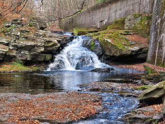
![]()
![]()
![]()
![]()
![]() On Thursday, November 7th, I wanted to take Sheena our new puppy for a walk on the Parksville Rail Trail from Fox Mountain Road. The Parksville Rail Trail is under three miles out and back but carrying a pack and keeping a quick pace helps increase the difficulty. The last time I took Sheena on this hike, I had the feeling that she could have done it again when we got back to the car. That was almost two weeks ago and I was sure she more than capable of the same amount of energy! I asked Cindy if she would like to go and she agreed as the trail is flat which is her preferred terrain. I made sure I had an EMT and driver ready to cover calls so that I could enjoy a little down time. As I was getting dressed at 1:00 PM, I remembered how much Sheila liked to hike this trail and take a swim at the falls. It seemed that Sheena likes hiking as she smells my clothes and then runs to sit by the door! I am looking forward to the time when I can let her off her leash. I found that since Sheila passed away I still feel she is with me on hikes and I have vivid memories of her on each trail. It was 55 degrees on the back porch with a stiff breeze blowing. I got dressed in my White Sierra long-sleeved crew top without a baselayer thinking did not want to sweat as I did last time. I put on a pair of RailRiders hiking pants which are expensive but last a long time and have features like deep pockets and a generous cut which I really like. I decided to put on my Keen Durand hiking boots which fit well. I added a new pair of Xstance insoles in an effort to find the best support and cushioning for my feet. These insoles have shock absorbing gel pads, TPU arch support, and memory foam cushioning all wrapped in a breathable fabric. The insoles have been hyped by their manufacturer and seemed to be living up to their claims. I put on my Mammut hoody which has plenty of zippers to dump heat but blocks the wind. I decided not to take any poles as I would have Sheena on her leash. I put our gear in the back of the car and left Livingston Manor at 1:10 PM. I drove out Old Route 17 toward Parksville and pulled into the parking area on the right side of the road just after Fox Mountain Rd. There were no cars parked in the lot when we arrived. I left my phone in the car so I could enjoy the hike. We started out on the trail at 1:18 PM under beautiful blue skies with plenty of sun and puffy white clouds in one direction and dark clouds and overcast in the other. The temperature in the sun has right around 56 degrees but the breeze made it feel much cooler. I put a light leash on Sheena and encouraged her to jump down out of the car. Once of the ground she immediately began to pull me to the trailhead and up the trail.
On Thursday, November 7th, I wanted to take Sheena our new puppy for a walk on the Parksville Rail Trail from Fox Mountain Road. The Parksville Rail Trail is under three miles out and back but carrying a pack and keeping a quick pace helps increase the difficulty. The last time I took Sheena on this hike, I had the feeling that she could have done it again when we got back to the car. That was almost two weeks ago and I was sure she more than capable of the same amount of energy! I asked Cindy if she would like to go and she agreed as the trail is flat which is her preferred terrain. I made sure I had an EMT and driver ready to cover calls so that I could enjoy a little down time. As I was getting dressed at 1:00 PM, I remembered how much Sheila liked to hike this trail and take a swim at the falls. It seemed that Sheena likes hiking as she smells my clothes and then runs to sit by the door! I am looking forward to the time when I can let her off her leash. I found that since Sheila passed away I still feel she is with me on hikes and I have vivid memories of her on each trail. It was 55 degrees on the back porch with a stiff breeze blowing. I got dressed in my White Sierra long-sleeved crew top without a baselayer thinking did not want to sweat as I did last time. I put on a pair of RailRiders hiking pants which are expensive but last a long time and have features like deep pockets and a generous cut which I really like. I decided to put on my Keen Durand hiking boots which fit well. I added a new pair of Xstance insoles in an effort to find the best support and cushioning for my feet. These insoles have shock absorbing gel pads, TPU arch support, and memory foam cushioning all wrapped in a breathable fabric. The insoles have been hyped by their manufacturer and seemed to be living up to their claims. I put on my Mammut hoody which has plenty of zippers to dump heat but blocks the wind. I decided not to take any poles as I would have Sheena on her leash. I put our gear in the back of the car and left Livingston Manor at 1:10 PM. I drove out Old Route 17 toward Parksville and pulled into the parking area on the right side of the road just after Fox Mountain Rd. There were no cars parked in the lot when we arrived. I left my phone in the car so I could enjoy the hike. We started out on the trail at 1:18 PM under beautiful blue skies with plenty of sun and puffy white clouds in one direction and dark clouds and overcast in the other. The temperature in the sun has right around 56 degrees but the breeze made it feel much cooler. I put a light leash on Sheena and encouraged her to jump down out of the car. Once of the ground she immediately began to pull me to the trailhead and up the trail.
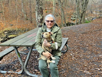 The first part of the trail was completely dry and everything around the trail was even drier. There is a burn ban in Sullivan County and there have been several brush and forest fires. The bright sun felt warm but the breeze offset it. Once we were on the trail and sheltered by the trees it was a little cooler and the trail was about as I expected with a few damp spots. The rail trail runs parallel to the Little Beaverkill and the new section of State Route 17. It follows the route of the O&W railroad and is very flat. Sheena was setting a quick pace but I did not want to race out and back as fast as possible. The water level in the stream was at an even lower level than it had been just two weeks ago. The trail had a few small branches which bent over to remove from the trail. I wondered if we would run into any larger branches or trees down across the trail with the winds that had been blowing lately. The area just before the wooden walkways showed some interesting views so I stopped to take some shots. After that, I positioned Sheena on the wooden walkway and tried to get some pictures. Sheena would sit and look around and then move. I finally got a few shots and we moved on. We walked across the wooden walkways which were starting to show some layers of mud from the runoff from the highway runoff. We walked passed several trees that had been cut and cleared. We came to the mudslide that had brought several trees down across the trail. All of these trees had been cut with a chainsaw and removed. There was a little water and a thin layer of mud so Sheena was reluctant to cross but did so with my encouragement. Just after this area was another tree that a crew had cut and cleared. As we walked, we could hear an increase in the noise from the stream and I knew the falls were just ahead. We reached the falls at 1:45 PM after hiking 27 minutes. I pointed Sheena to the path down to the base of the falls and she reluctantly started down the path with me. Cindy parked herself on the picnic bench to wait for us. With a little encouragement, Sheena made it to the stream bed where I told her to sit and stay.
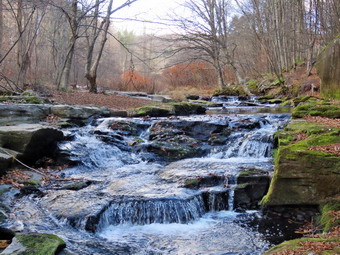 I put my pack down and got out my camera. The water level was very low but so was the light level which made the falls interesting. I took pictures of the falls using different zooms and angles. I turned around and took some shots downstream. Sheena was not "staying" so I let her explore a little. She went to the edge of the stream and got a drink. When we were done, I stowed the camera and worked our way back up to the main trail. Cindy pick Sheena up and held her so I could take some shots to compare to the first time we had hiked here. Sheena was definitely larger! I got the camera out again and snapped a few more shots from above the falls and a few more upstream. When I was done, we started on the trail toward the Parksville trailhead. We stopped at the next bench and I gave Sheena's leash to Cindy. I got out the camera and walked down to the edge of the stream and took some shots of the stream. The area was usually covered with water but now many areas had only damp rocks. The water level was so low that I was able to walk along the edge of the stream to the brink of the falls. I took some shots from the top of the falls downstream and upstream. I worked my way back upstream taking a few shots as I went. I joined Cindy and Sheena back at the bench and stowed the camera. We started toward Parksville with Sheena in the lead pushing the pace. She was trying to do zoomies on a very short leash! I am hoping to be able to let her off her leash to hike sometime soon. Within 5 or 6 minutes, we reached the sign at the Parksville end of the rail trail. At 2:08 PM, we immediately turned around and started back toward the car. As we passed one of the houses, a few dogs began to bark and Sheena had an interesting response. The hair stood up along the ridge on her back, she gave a couple of yips, and then started back on the trail at an accelerated pace. She set a fast pace which would have required us to run so I restrained her a little and she slowed down. We were back at the falls in 6 minutes and we continued the hike without stopping. We met no one on the hike and were soon breaking out into the sun and approaching the parking area. We arrived back at the car at 2:35 PM after hiking around 2 miles in 1 hour and 17 minutes including the time to take pictures! There had been no ambulance calls while we were on the trail! Sheena has doubled in weight since her first hike on the rail trail. It seemed to me that she definitely could haved hike out and back on the trail another time and still enjoyed it.
![]()
![]()
![]()
![]() On Monday, November 4th I planned to get out for a hike on Round Top with my new dog Sheena. She is a Feist-Cur cross which are actual types of dogs used on farms and for hunting in the south. She probably won't get to be more than 30 pounds which makes Cindy happy although I would have preferred a larger dog. She was born the day after Sheila died. I had an early morning ambulance call which turned put to be rather ordinary. When I came home, I took a nap with Sheena for about an hour. I started to get ready to hike at 1:30 PM with the temperature at 51 degrees on the back porch with a good breeze blwoing. I got dressed in my Mammut long-sleeved crew top without a baselayer thinking about the last time I wore another layer and came back drenched in sweat. I put on a pair of RailRiders hiking pants which are expensive but last a long time and have features like deep pockets and a generous cut which I really like. I decided to put on my Keen Durand hiking boots which fit well. I added a new pair of Xstance insoles in an effort to find the best support and cushioning for my feet. These insoles have shock absorbing gel pads, TPU arch support, and memory foam cushioning all wrapped in a breathable fabric. The insoles have been hyped by their manufacturer and seemed to be living up to their claims. I did put on my Mammut hoody for the first time this fall. I felt that the pitzips would allow me to dump enough heat if I was too warm. I decided not to take any poles as the walk would be short and I would be holding Sheena's leash. At 1:50 PM I put Sheena on her leash and we walked out the door to start the hike. We headed down the driveway and toward the street. Sheena has gotten used to walking on her leash to the end of the drive but gets nervous as we get near the road. This time she readily crossed without me carrying her across the street. After crossing the street, Sheena headed through the field by the church straining at her leash. We walked to the back of the church and began the ascent of the steepest hill behind the church. Sheena had no problem walking up the hill except for the fact that she likes to stop and sniff very frequently. The hill is short but gets the circulation pumping and is the steepest and longest climb on the "trail." Not having poles made it more of a challenge. We did not stop on the way to the top of the hill and set a fast pace. Sheena is getting bigger every day and her pull on the leash is signficant. At the top we paused for a minute so I could look around at the hills that surround the hamlet of Livingston Manor. The skies were overcast with the sun barely shining from behind the clouds. Sheena was eager to enter the woods on the trail and hopped right up the steps. The trail was dry with a lot off leaves.
On Monday, November 4th I planned to get out for a hike on Round Top with my new dog Sheena. She is a Feist-Cur cross which are actual types of dogs used on farms and for hunting in the south. She probably won't get to be more than 30 pounds which makes Cindy happy although I would have preferred a larger dog. She was born the day after Sheila died. I had an early morning ambulance call which turned put to be rather ordinary. When I came home, I took a nap with Sheena for about an hour. I started to get ready to hike at 1:30 PM with the temperature at 51 degrees on the back porch with a good breeze blwoing. I got dressed in my Mammut long-sleeved crew top without a baselayer thinking about the last time I wore another layer and came back drenched in sweat. I put on a pair of RailRiders hiking pants which are expensive but last a long time and have features like deep pockets and a generous cut which I really like. I decided to put on my Keen Durand hiking boots which fit well. I added a new pair of Xstance insoles in an effort to find the best support and cushioning for my feet. These insoles have shock absorbing gel pads, TPU arch support, and memory foam cushioning all wrapped in a breathable fabric. The insoles have been hyped by their manufacturer and seemed to be living up to their claims. I did put on my Mammut hoody for the first time this fall. I felt that the pitzips would allow me to dump enough heat if I was too warm. I decided not to take any poles as the walk would be short and I would be holding Sheena's leash. At 1:50 PM I put Sheena on her leash and we walked out the door to start the hike. We headed down the driveway and toward the street. Sheena has gotten used to walking on her leash to the end of the drive but gets nervous as we get near the road. This time she readily crossed without me carrying her across the street. After crossing the street, Sheena headed through the field by the church straining at her leash. We walked to the back of the church and began the ascent of the steepest hill behind the church. Sheena had no problem walking up the hill except for the fact that she likes to stop and sniff very frequently. The hill is short but gets the circulation pumping and is the steepest and longest climb on the "trail." Not having poles made it more of a challenge. We did not stop on the way to the top of the hill and set a fast pace. Sheena is getting bigger every day and her pull on the leash is signficant. At the top we paused for a minute so I could look around at the hills that surround the hamlet of Livingston Manor. The skies were overcast with the sun barely shining from behind the clouds. Sheena was eager to enter the woods on the trail and hopped right up the steps. The trail was dry with a lot off leaves.
At the first trail junction, we continued straight up the hill with Sheena leading the way on her leash. When we reached the top of the hill, we followed the yellow trail as it turned right. The trails were covered with multicolored leaves but many were just brown and dry. There were almost no leaves on the trees. We walked uphill through the field of ferns that was almost completely brown with the nighttime temperatures in the high 20's. When we reached the "sitting rock", Sheena hopped on the lower rock and sniffed around. Finding nothing interesting on the rock, Sheena jumped down and started up the trail at an accelerated pace. The woods around us would be silent except for the traffic on the Quickway. We continued on the yellow trail up a small hill to the junction with the blue trail to the summit. I decided we would do a figure 8 so we turned right on the yellow trail. We followed the yellow trail along the base of Round Top with Sheena wanting to run ahead. I did my best to keep up with her. At the next junction with the blue trail, we turned left and headed up toward the summit. Sheena showed no sign of slowing down and helped pull me quickly up the hill. We passed over the highest point on the trail and started down the other side. We passed by the white crossover trail but almost immediately turned left on the switchback in the blue trail. We walked out into the woods and turned almost 180 degrees to head back to the main blue trail. On the main blue trail we turned left and again walked on the yellow trail along the base of Round Top. At the next junction with the blue trail we turned right and headed down the yellow trail. Along the way we came across a medium sized trunk across the trail. I had seen this before but kept forgetting to bring a saw or ax to eliminated it. Where the trail meets the woods road we turned right and continue downhill to the first trail junction. Sheena was in the lead for most of the hike and always seems to get the turns correct. Sheena had been behaving very well on the leash. She had tried biting her leash and playing while hiking. I told her "stop" and she did so almost immediately. She darted pulling on her leash and I told her "With" and she came back to walk at my heels. I really hope I can get an electronic collar for her and Reese her from the leash. Sheena had a lot of energy left so I deicded to turn around on get in at least another small loop.
We walked up the woods road with Sheena pushing the pace. At the end of the woods road we turned left on the yellow trail and head up to the first junction with the blue trail. We turned left on the yellow trail at the junction and walked along the base of Round Top to the next junction with the blue trail. Since Sheena was still interested in hiking, we turned right and headed up the blue trail toward the summit. For some variety, we bypassed the switchback and continued toward the summit on the main blue trail. This section of trail is very steep but Sheena handled without a problem. When we came to the white crossover trail, I decided we would turn right and walk that trail over to the blue trail coming down off the summit. We walked the white trail which seemed lightly used as I actually had to look at the blazes a couple of times. When we came to the blue trail, we turned right and headed downhill. At the next junction with the yellow trail, we turned right and again walked along the base of Round Top. At the next trail junction, we turned right and headed toward the lookout. Along the way we came to a boudler which Sheena wanted to climb. She could not quite make the top so I picked her up and put her on top. She sniffed around and then launched herself off the rock to the ground. She made the jump with out any fear and landed perfectly! We continued downhill on the yellow trail and came to the "Sitting Rocks". Sheena again jumped up on the lower rock and looked around. She must have smelled something interesting on the other side of the rock because she walked to the edge and then started to climb down that side of the rock upside down! Her sharp nails allow her to hang onto the coarse surface of the rock until she was on the ground. We walked on the yellow trail down to the viewpoint amd continued to follow the trail as it turned left. We started to descend the trail which was covered in a heavy layer of dead leaves. Sheena showed she still had a lot of energy left as she was biting the leash, growling, and skidding downhill through the leaves. I decided to let her have her fun until we got to the first trail,junction. We walked out to the trailhead and turned right to walk down the cemetery hill to the church parking lot. We walked across the field by the church with Sheena distracted by a group of young people walking home from school. She walked across the road after I looked both ways. It was 2:15 PM and it had taken us and hour and 20 minutes to hike around 2 miles. Sheena drank a lot of water and then laid down by me for a nap.
![]()
![]()
![]()
![]() On Saturday, November 2nd I planned to get out for a hike on Round Top with my new dog Sheena. She is a Feist-Cur cross which are actual types of dogs used on farms and for hunting in the south. She probably won't get to be more than 30 pounds which makes Cindy happy although I would have preferred a larger dog. She was born the day after Sheila died. I started to get ready to hike at 12:15 PM after returning from two early morning ambulance calls. The temperature was 44 degrees on the back porch. I was already dressed in my BDU pants and long-sleeved corps T-shirt ao I just decided to go hiking without getting changed. I was wearing an old pair of Keen Durand hiking boots with Protalus insoles which I knew would do the job for hiking. I did put on my Mammut hoody for the first time this fall. I felt that the pitzips would allow me to dump enough heat if I was too warm. I decided not to take any poles as the walk would be short and I would be holding Sheena's leash. At 12:30 PM I put Sheena on her leash and we walked out the door to start the hike. We headed down the driveway and toward the street. Sheena has gotten used to walking on her leash to the end of the drive but sometimes gets nervous as we get near the road. This time she walked to the edge of the street and waited until I said "OK" and then she crossed. She walked across the field by the church leading me toward the back of the church. She turned left and headed up the ascent of the steepest hill behind the church. Sheena had no problem walking up the hill except for the fact that she likes to stop and sniff very frequently. The hill is short but gets the circulation pumping and is the steepest and longest climb on the "trail." Not having poles made it more of a challenge. We did not stop on the way to the top of the hill but set a reasonable pace. I could feel that I had not been hiking enough lately but Sheena is now bigger and her pull on the leash is signficant. On the way up a dig was baring at one of the houses next to the cemetery which was a great distraction to Sheena. At the top we paused for a minute so I could look around at the hills that surround the hamlet of Livingston Manor. The skies were blue with a few white clouds and bright sunshine. All of the leaves were gone from the trees and had a distinct winter feel but without the snow. Sheena was eager to enter the woods on the trail and jumped from the road to the top step! The leaves on the trail were a little damp and the temperature under the trees seemed cooler than in the sun.
On Saturday, November 2nd I planned to get out for a hike on Round Top with my new dog Sheena. She is a Feist-Cur cross which are actual types of dogs used on farms and for hunting in the south. She probably won't get to be more than 30 pounds which makes Cindy happy although I would have preferred a larger dog. She was born the day after Sheila died. I started to get ready to hike at 12:15 PM after returning from two early morning ambulance calls. The temperature was 44 degrees on the back porch. I was already dressed in my BDU pants and long-sleeved corps T-shirt ao I just decided to go hiking without getting changed. I was wearing an old pair of Keen Durand hiking boots with Protalus insoles which I knew would do the job for hiking. I did put on my Mammut hoody for the first time this fall. I felt that the pitzips would allow me to dump enough heat if I was too warm. I decided not to take any poles as the walk would be short and I would be holding Sheena's leash. At 12:30 PM I put Sheena on her leash and we walked out the door to start the hike. We headed down the driveway and toward the street. Sheena has gotten used to walking on her leash to the end of the drive but sometimes gets nervous as we get near the road. This time she walked to the edge of the street and waited until I said "OK" and then she crossed. She walked across the field by the church leading me toward the back of the church. She turned left and headed up the ascent of the steepest hill behind the church. Sheena had no problem walking up the hill except for the fact that she likes to stop and sniff very frequently. The hill is short but gets the circulation pumping and is the steepest and longest climb on the "trail." Not having poles made it more of a challenge. We did not stop on the way to the top of the hill but set a reasonable pace. I could feel that I had not been hiking enough lately but Sheena is now bigger and her pull on the leash is signficant. On the way up a dig was baring at one of the houses next to the cemetery which was a great distraction to Sheena. At the top we paused for a minute so I could look around at the hills that surround the hamlet of Livingston Manor. The skies were blue with a few white clouds and bright sunshine. All of the leaves were gone from the trees and had a distinct winter feel but without the snow. Sheena was eager to enter the woods on the trail and jumped from the road to the top step! The leaves on the trail were a little damp and the temperature under the trees seemed cooler than in the sun.
At the first trail junction, I followed Sheena as she turned right to head up the woods road which is the shallower approach to the trail system. Sheena seemed to have no problem leading me by pulling on her leash. Along the way, I stopped to remove some small branches and a few larger ones. At the end of the woods road, Sheena turned left on the yellow trail and continued uphill and I followed. I picked up a few branches along the way before we cam to a small trunk acrossed the trail which would require a saw or ax to remove. At the first junction with the blue trail we turned left to walk along the base of Round Top. Sheena always likes to run along this part of the trail. She will strain at her leash if I don't at least jog behind her so that's what I did. When we arrived at the junction with the blue trail, we turned right and started up the hill. Sheena turned right on the switchback without my prompting and I followed her. We haven't been over the trails too many times so I don't know if she was following a scent track just got lucky. We walked on the switchback out into the forest and then back to the main blue trail. We turned right and walked on the blue trail over the highest point. As we started down the other side, Sheena wanted to go at a pace I could not match and keep my balance at the same time. I slowed Sheena down by pulling on her leash and saying "Don't pull" and "With" which have both started to work. When we got to the trail junction with the yellow trail, we turned right and again followed the yellow along the base of Round Top. This time when we came to the junction with the blue trail, we stayed to the left and followed the yellow trail downhill. We came to the "Sitting Rock" where Sheena jumped up on the lower rock and sniffed around. She eyed the higher rock but I don't think she will ever make that jump! After a few minutes, Sheena was satisfied and we continued on the trail. We passed through the ferns which were now brown and continued to the lookout. Sheena and I continued down the hill toward the first trail junction. Sheena again wanted to descend at top speed. She would run ahead and then sprawl in the leaves and slide further down the trail. After doing this a few times, she slid off the trail and had to scramble up the steep bank. This incident didn't phase her much and she start in all over again. At the first junction we continued straight out to the trailhead. I had hoped to do at least another small loop but this had been a good hike yet and I did not want to press my luck. I am hoping to be able to let her off her leash soon perhaps with the help of an electronic collar. I think this will benefit both of us but I have to be sure Sheena will come back when called. We turned right and walked down the road to the back of the church. Sheena is still shy near roads but she crossed the field by the church and, with a little encouragement, crossed the street to our driveway. We were back at the house by 1:15 PM and it had taken us 45 minutes to hike a little more than a mile. Sheena drank a lot of water and then laid down by me for a long nap.
![]()
![]()
![]()
![]() On Wednesday, October 30th I planned to get out for a hike on Round Top with my new dog Sheena. She is a Feist-Cur cross which are actual types of dogs used on farms and for hunting in the south. She probably won't get to be more than 30 pounds which makes Cindy happy although I would have preferred a larger dog. She was born the day after Sheila died. Lisa had called me and she wanted to hike on Round Top at 10:00 AM. I had an early morning call and when I got home I took care of Sheena, got Cindy her morning tea, and got a short nap. I woke up at 9:35 AM and scurried to get ready to hike. The temperature waa 46 degrees on the back porch. I got dressed in my Mammut long-sleeved crew top with a long-sleeved baselayer thinking I would need a little warmth as the temperature was 55 degrees with a stiff breeze. I put on a pair of RailRiders hiking pants which are expensive but last a long time and have features like deep pockets and a generous cut which I really like. I decided to put on my Keen Durand hiking boots which fit well. I added a new pair of Xstance insoles in an effort to find the best support and cushioning for my feet. These insoles have shock absorbing gel pads, TPU arch support, and memory foam cushioning all wrapped in a breathable fabric. The insoles have been hyped by their manufacturer and seemed to be living up to their claims. I decided not to take any poles as the walk would be short and I would be holding Sheena's leash. At 9:55 AM I put Sheena on her leash and we walked out the door to start the hike. We headed down the driveway and toward the street. Sheena has gotten used to walking on her leash to the end of the drive but gets nervous as we get near the road. This time she readily crossed without me carrying her across the street. After crossing the street, Sheena headed through the field by the church straining at her leash. I did not see Lisa's car in the lot so I sat on the bench by the backdoor of the church. After a few minutes I checked my phone and found Lisa was not going to be there until 10:15 AM! Sheena is not good at waiting but at 10:15 AM Lisa pulled into the lot. Sheena gave her a full body welcome and then we waited for her to get ready to hike. Around 10:20 AM, we walked to the back of the church and began the ascent of the steepest hill behind the church. Sheena had no problem walking up the hill except for the fact that she likes to stop and sniff very frequently. The hill is short but gets the circulation pumping and is the steepest and longest climb on the "trail." Not having poles made it more of a challenge. We did not stop on the way to the top of the hill and set a fast pace. Sheena continues to grow and her pull on the leash is signficant. At the top we paused for a minute so we could look around at the hills that surround the hamlet of Livingston Manor. The skies were blue with a few white clouds and bright sunshine. Sheena was eager to enter the woods on the trail and hopped right up the steps. The trail was dry and the temperature under the trees seemed cooler than in the sun.
On Wednesday, October 30th I planned to get out for a hike on Round Top with my new dog Sheena. She is a Feist-Cur cross which are actual types of dogs used on farms and for hunting in the south. She probably won't get to be more than 30 pounds which makes Cindy happy although I would have preferred a larger dog. She was born the day after Sheila died. Lisa had called me and she wanted to hike on Round Top at 10:00 AM. I had an early morning call and when I got home I took care of Sheena, got Cindy her morning tea, and got a short nap. I woke up at 9:35 AM and scurried to get ready to hike. The temperature waa 46 degrees on the back porch. I got dressed in my Mammut long-sleeved crew top with a long-sleeved baselayer thinking I would need a little warmth as the temperature was 55 degrees with a stiff breeze. I put on a pair of RailRiders hiking pants which are expensive but last a long time and have features like deep pockets and a generous cut which I really like. I decided to put on my Keen Durand hiking boots which fit well. I added a new pair of Xstance insoles in an effort to find the best support and cushioning for my feet. These insoles have shock absorbing gel pads, TPU arch support, and memory foam cushioning all wrapped in a breathable fabric. The insoles have been hyped by their manufacturer and seemed to be living up to their claims. I decided not to take any poles as the walk would be short and I would be holding Sheena's leash. At 9:55 AM I put Sheena on her leash and we walked out the door to start the hike. We headed down the driveway and toward the street. Sheena has gotten used to walking on her leash to the end of the drive but gets nervous as we get near the road. This time she readily crossed without me carrying her across the street. After crossing the street, Sheena headed through the field by the church straining at her leash. I did not see Lisa's car in the lot so I sat on the bench by the backdoor of the church. After a few minutes I checked my phone and found Lisa was not going to be there until 10:15 AM! Sheena is not good at waiting but at 10:15 AM Lisa pulled into the lot. Sheena gave her a full body welcome and then we waited for her to get ready to hike. Around 10:20 AM, we walked to the back of the church and began the ascent of the steepest hill behind the church. Sheena had no problem walking up the hill except for the fact that she likes to stop and sniff very frequently. The hill is short but gets the circulation pumping and is the steepest and longest climb on the "trail." Not having poles made it more of a challenge. We did not stop on the way to the top of the hill and set a fast pace. Sheena continues to grow and her pull on the leash is signficant. At the top we paused for a minute so we could look around at the hills that surround the hamlet of Livingston Manor. The skies were blue with a few white clouds and bright sunshine. Sheena was eager to enter the woods on the trail and hopped right up the steps. The trail was dry and the temperature under the trees seemed cooler than in the sun.
At the first trail junction, we continued straight up the hill with Sheena leading the way on her leash. Lisa and I immediately started to converse as we had not seen each other in some time. When we reached the top of the hill, we followed the yellow trail as it turned right. The trails were covered with multicolored leaves but many were just brown and dry. The leaves on the trees were becoming fewer and fewer and the colors were very muted. We walked uphill through the field of ferns that was almost completely brown with the nighttime temperatures in the low 30's. When we reached the "sitting rock", Sheena hopped on the lower rock and sniffed around. This is becoming a regular part of this hike for her. Finding nothing interesting on the rock, Sheena jumped down and started up the trail at an acellerated pace. The woods around us would be silent except for the traffic on the Quickway. We continued on the yellow trail up a small hill to the junction with the blue trail to the summit. We decided we would do a figure 8 so we turned right on the yellow trail. We followed the yellow trail along the base of Round Top with Sheena wanting to run ahead. I did my best to keep up with her. At the next junction with the blue trail, we turned left and headed up toward the summit. Sheena showed no sign of slowing down and helped pull me quickly up the hill. Just before the summit, my phone sounded announcing an ambulance call! I called in and said goodbye to Lisa. Sheena and I started back down the hill as fast as I could go. At the trail junction we continued straight ahead on the yellow trail. Along the way we came across a medium sized trunk across the trail. I had seen this before but kept forgetting to bring a saw or ax to eliminated it. Where the trail meets the woods road we turned right and continue downhill to the first trail junction. Sheena was in the lead for most of the hike and always seems to get the turns correct. We turned left at the first trail junction and walked out to the trailhead. We turned right and walked down the cemetery hill to the church parking lot. We walked across the field by the church with Sheena shying a bit whenever a car passed. She did walk across the road after I looked both ways. It only took us about 10 minutes to get back to the house. I put Sheena in her kennel and changed into a corps shirt. I ran out front where my partner picked me up in the ambulance and we headed for Liberty. Sixty to seventy percent of the calls we cover are not in our district.
![]()
![]()
![]()
![]() On Monday, October 28th I planned to get out for a hike on Round Top with my new dog Sheena. She is a Feist-Cur cross which are actual types of dogs used on farms and for hunting in the south. She probably won't get to be more than 30 pounds which makes Cindy happy although I would have preferred a larger dog. She was born the day after Sheila died. I started to get ready to hike at 11:00 AM with the temperature at 50 degrees on the back porch. I had just returned from a call so I wore my corps shirt and BDU pants because I knew the hike would probably be only one figure 8. I decided to wear my old Keen Durand hiking boots with a pair of Protalus insoles. These insoles have shock absorbing gel pads that really do seem to help cushion my foot. I did put on a new Baerskin fleece hoody for the first time. I thought it was cool enough to wear this new piece. I decided not to take any poles as the walk would be short and I would be holding Sheena's leash. At 11:15 AM I put Sheena on her leash and we walked out the door to start the hike. We headed down the driveway and toward the street. Sheena has gotten used to walking on her leash to the end of the drive but gets nervous as we get near the road. This time she readily crossed without me carrying her across the street. After crossing the street, Sheena headed through the field my the church starting at her leash. We walked to the back of the church and began the ascent of the steepest hill behind the church. Sheena had no problem walking up the hill except for the fact that she likes to stop and sniff very frequently. The hill is short but gets the circulation pumping and is the steepest and longest climb on the "trail." Not having poles made it more of a challenge. We did not stop on the way to the top of the hill and set a fast pace. I could feel that I had not been hiking as much as I would like but Sheena is now bigger and her pull on the leash is signficant. At the top we paused for a minute so I could look around at the hills that surround the hamlet of Livingston Manor. The skies were blue with a few high, whispy, white clouds and bright sunshine. Sheena was eager to enter the woods on the trail and hopped right up the steps. The trail was dry and the temperature under the trees seemed cooler than in the sun.
On Monday, October 28th I planned to get out for a hike on Round Top with my new dog Sheena. She is a Feist-Cur cross which are actual types of dogs used on farms and for hunting in the south. She probably won't get to be more than 30 pounds which makes Cindy happy although I would have preferred a larger dog. She was born the day after Sheila died. I started to get ready to hike at 11:00 AM with the temperature at 50 degrees on the back porch. I had just returned from a call so I wore my corps shirt and BDU pants because I knew the hike would probably be only one figure 8. I decided to wear my old Keen Durand hiking boots with a pair of Protalus insoles. These insoles have shock absorbing gel pads that really do seem to help cushion my foot. I did put on a new Baerskin fleece hoody for the first time. I thought it was cool enough to wear this new piece. I decided not to take any poles as the walk would be short and I would be holding Sheena's leash. At 11:15 AM I put Sheena on her leash and we walked out the door to start the hike. We headed down the driveway and toward the street. Sheena has gotten used to walking on her leash to the end of the drive but gets nervous as we get near the road. This time she readily crossed without me carrying her across the street. After crossing the street, Sheena headed through the field my the church starting at her leash. We walked to the back of the church and began the ascent of the steepest hill behind the church. Sheena had no problem walking up the hill except for the fact that she likes to stop and sniff very frequently. The hill is short but gets the circulation pumping and is the steepest and longest climb on the "trail." Not having poles made it more of a challenge. We did not stop on the way to the top of the hill and set a fast pace. I could feel that I had not been hiking as much as I would like but Sheena is now bigger and her pull on the leash is signficant. At the top we paused for a minute so I could look around at the hills that surround the hamlet of Livingston Manor. The skies were blue with a few high, whispy, white clouds and bright sunshine. Sheena was eager to enter the woods on the trail and hopped right up the steps. The trail was dry and the temperature under the trees seemed cooler than in the sun.
At the first trail junction, we continued straight up the hill with Sheena leading the way on her leash. When we reached the top of the hill, we followed the yellow trail as it turned right. Sheena did take a minute to pull me over to the lookout before going back to the main trail. The trails were covered with multicolored leaves but many were just brown and dry. The leaves on the trees were becoming fewer and fewer and the colors were very muted. We walked uphill through the field of ferns that was almost completely brown with the nighttime temperatures in the low 30's. When we reached the "sitting rock", Sheena hopped on the lower rock and sniffed around. Finding nothing interesting on the rock, Sheena jumped down and started up the trail at an acellerated pace. The woods around us would be silent except for the traffic on the Quickway. We continued on the yellow trail up a small hill to the junction with the blue trail to the summit. I decided we would do a figure 8 so we turned right on the yellow trail. We followed the yellow trail along the base of Round Top with Sheena wanting to run ahead. I did my best to keep up with her. At the next junction with the blue trail, we turned left and headed up toward the summit. Sheena showed no sign of slowing down and helped pull me quickly up the hill. We passed over the highest point on the trail and started down the other side. We passed by the white crossover trail but almost immediately turned left on the switchback in the blue trail. We walked out into the woods and turned almost 180 degrees to head back to the main blue trail. On the main blue trail we turned left and again walked on the yellow trail along the base of Round Top. At the next junction with the blue trail we turned right and headed down the yellow trail. Along the way we came across a medium sized trunk across the trail. I had seen this before but kept forgetting to bring a saw or ax to eliminated it. Where the trail meets the woods road we turned right and continue downhill to the first trail junction. Sheena was in the lead for most of the hike and always seems to get the turns correct. I though about doing another section of trail but I was sweating profusely. The new hoody was very warm despot the fact that I had opened the zipper almost all the way. I decided we would return home. We turned left and walked out to the trailhead. We turned right and walked down the cemetery hill to the church parking lot. We walked across the field by the church with Sheena shying a bit whenever a car passed. She did walk across the road after I looked both ways. It was 12:00 PM and it had taken us 45 minutes to hike a little more than a mile. Sheena drank a lot of water and then laid down by me for a long nap.
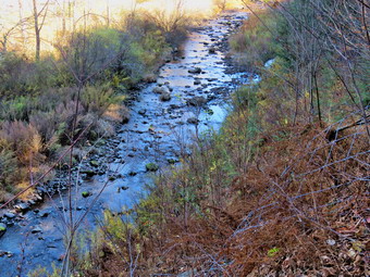
![]()
![]()
![]()
![]()
![]() On Thursday, October 24th, I wanted to take Sheena our new puppy for a walk on the Parksville Rail Trail from Fox Mountain Road. The Parksville Rail Trail is under three miles out and back but carrying a pack and keeping a quick pace helps increase the difficulty. The last time I took Sheena on this hike, I had to carry her most of the way back. That was more than a month ago and I wondered how she would treat the hike this time. As I was getting dressed at 1:10 PM, I remembered how much Sheila liked to hike this trail and take a swim at the falls. I hoped Sheena would like hiking as much as Sheila and was looking forward to the time when I could let her off her leash. I found that since Sheila passed away I still feel she is with me on hikes and I have vivid memories of her on each trail. I got dressed in my Mammut long-sleeved crew top with a long-sleeved baselayer thinking I would need a little warmth as the temperature was 55 degrees with a stiff breeze. I put on a pair of RailRiders hiking pants which are expensive but last a long time and have features like deep pockets and a generous cut which I really like. I decided to put on my Keen Durand hiking boots which fit well. I added a new pair of Xstance insoles in an effort to find the best support and cushioning for my feet. These insoles have shock absorbing gel pads, TPU arch support, and memory foam cushioning all wrapped in a breathable fabric. The insoles have been hyped by their manufacturer and seemed to be living up to their claims. I decided not to take any poles as I would have Sheena on her leash. I put my gear in the back of the car and left Livingston Manor at 1:15 PM. I drove out Old Route 17 toward Parksville and pulled into the parking area on the right side of the road just after Fox Mountain Rd. There were no cars parked in the lot when we arrived. I took my phone with me so that I could respond to ambulance calls in an emergency. We started out on the trail at 1:28 PM under beautiful blue skies with plenty of sun but none of the puffy white clouds that enhance pictures. The temperature in the sun has right around 56 degrees but the breeze made it feel much cooler. I put a light leash on Sheena and encouraged her to jump down out of the car. Once of the ground She immediately began to pull me to the trailhead and up the trail.
On Thursday, October 24th, I wanted to take Sheena our new puppy for a walk on the Parksville Rail Trail from Fox Mountain Road. The Parksville Rail Trail is under three miles out and back but carrying a pack and keeping a quick pace helps increase the difficulty. The last time I took Sheena on this hike, I had to carry her most of the way back. That was more than a month ago and I wondered how she would treat the hike this time. As I was getting dressed at 1:10 PM, I remembered how much Sheila liked to hike this trail and take a swim at the falls. I hoped Sheena would like hiking as much as Sheila and was looking forward to the time when I could let her off her leash. I found that since Sheila passed away I still feel she is with me on hikes and I have vivid memories of her on each trail. I got dressed in my Mammut long-sleeved crew top with a long-sleeved baselayer thinking I would need a little warmth as the temperature was 55 degrees with a stiff breeze. I put on a pair of RailRiders hiking pants which are expensive but last a long time and have features like deep pockets and a generous cut which I really like. I decided to put on my Keen Durand hiking boots which fit well. I added a new pair of Xstance insoles in an effort to find the best support and cushioning for my feet. These insoles have shock absorbing gel pads, TPU arch support, and memory foam cushioning all wrapped in a breathable fabric. The insoles have been hyped by their manufacturer and seemed to be living up to their claims. I decided not to take any poles as I would have Sheena on her leash. I put my gear in the back of the car and left Livingston Manor at 1:15 PM. I drove out Old Route 17 toward Parksville and pulled into the parking area on the right side of the road just after Fox Mountain Rd. There were no cars parked in the lot when we arrived. I took my phone with me so that I could respond to ambulance calls in an emergency. We started out on the trail at 1:28 PM under beautiful blue skies with plenty of sun but none of the puffy white clouds that enhance pictures. The temperature in the sun has right around 56 degrees but the breeze made it feel much cooler. I put a light leash on Sheena and encouraged her to jump down out of the car. Once of the ground She immediately began to pull me to the trailhead and up the trail.
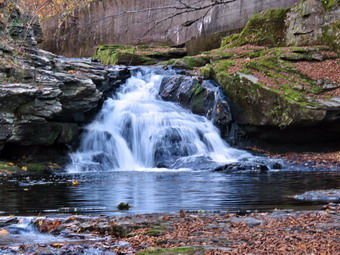 The first part of the trail was completely dry. The bright sun felt warm but the breeze offset it. Once we were on the trail and sheltered by the trees it was a little cooler and the trail was about as I expected with a few damp spots and some limited mud. It was cool enough that I wondered if I had made a mistake by not wearing a jacket and light hat. The rail trail runs parallel to the Little Beaverkill and the new section of State Route 17. It follows the route of the O&W railroad and is very flat. Sheena was setting a quick pace but I did not want to race out and back as fast as possible. The water level in the stream was at a lower level than it had been in some time. The trail had a few small branches which bent over to remove from the trail. I wondered if we would run into any larger branches or trees down across the trail. The area just before the wooden walkways showed some interesting views so I stopped to yake some shots. After that, I positioned Sheena on the wooden walkway and tried to get some pictures. Sheena would sit and look around and then move. I finally got a few shots and we moved on. We walked across the wooden walkways which were starting to show some layers of mud from the runoff from the highway. We walked passed several trees that had been cut and cleared. We came to the mudslide that had brought several trees down across the trail. All of these trees had been cut with a chainsaw and removed. There was a little water and a thin layer of mud so Sheena was reluctant to cross but did so with my encouragement. Just after this area was another tree that a crew had cut and cleared. As we walked, we could hear an increase in the noise from the stream and I knew the falls were just ahead. We reached the falls at 1:55 PM after hiking 27 minutes. I pointed Sheena to the path down to the base of the falls and she reluctantly started down the path. With a little encouragement, Sheena made it to the stream bed where I told her to sit and stay.
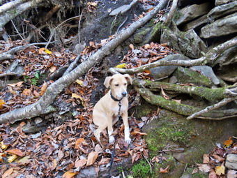 I put my pack down and got out my camera. The water was lower than it had been in some time but the falls were still interesting. I took pictures of the falls using different zooms and angles. I turned around and took some shots downstream. Sheena was not "staying" so I let her explore a little. She went to the edge of the stream and took a drink. I again tried to get her to sit for some shots and I did get a few. When we were done, I stowed the camera and worked our way back up to the main trail. I leashed Sheena to the picnic table and got the camera out again. I snapped a few more shots from above the falls and a few more upstream. When I was done, I unleashed Sheena and we started on the trail toward the Parksville trailhead. Sheena was in the lead and really wanted to push the pace. She was trying to do zoomies on a very short leash! I am hoping to be able to let her off her leash to hike sometime soon. Within 5 or 6 minutes, we reached the sign at the Parksville end of the rail trail. At 2:13, we immediately turned around and started back toward the car. As we passed one of the houses, a large red dog ran up to the fence and began barking. I jumped a little but Sheena had an interesting response. The hair stood up along the ridge on her back, she gave a couple of yips, and then started back on the trail at an accelerated pace. set a fast pace which would have required me to run so I restrained her a little and she slowed down. We were back at the falls in 6 minutes and we continued the hike without stopping. We met no one on the hike and were soon breaking out into the sun and approaching the parking area. We arrived back at the car at 2:37 PM after hiking 2 miles in 1 hour and 9 minutes including the time to take pictures! There had been no ambulance calls while we were on the trail! Sheena has doubled in weight since her first hike on the rail trail. It seemed to me that she could easily have hike another mile or more and she really enjoyed it.
![]()
![]()
![]()
![]() On Tuesday, October 722nd I planned to get out for a hike on Round Top with my new dog Sheena. She is a Feist-Cur cross which are actual types of dogs used on farms and for hunting in the south. She probably won't get to be more than 30 pounds which makes Cindy happy although I would have preferred a larger dog. She was born the day after Sheila died. I started to get ready to hike at 12:30 PM with the temperature at 72 degrees on the back porch with a slight breeze. I got dressed in my Mammut crew top with a shoer-sleeved baselayer as I did not want to wear a jacket. I wore my Railriders hiking pants which are expensive but last along time and have features like deep pockets and a generous cut which I really like. The pants have Velcro closures at the ankles. I decided to put on my Keen Durand hiking boots which I ordered a half size larger than the previous pair. These shoes fit well out of the box but get much tighter when I add a decent insole. Without the third party insole, by feet hurt from the lack of support. I added a new pair of Xstance insoles in an effort to find the best support and cushioning for my feet. These insoles have shock absorbing gel pads, TPU arch support, and memory foam cushioning all wrapped in a breathable fabric. The insoles have been hyped by their manufacturer and they really do seem to deliver. I decided not to take any poles as the walk would be short and I would be holding Sheena's leash. At 12:45 PM I put Sheena on her leash and we walked out the door to start the hike. We headed down the driveway and toward the street. Sheena has gotten used to walking on her leash to the end of the drive but gets nervous as we get near the road. This time she readily crossed without me carrying her across the street. After crossing the street, Sheena headed through the field my the church starting at her leash. We walked to the back of the church and began the ascent of the steepest hill behind the church. Sheena had no problem walking up the hill except for the fact that she likes to stop and sniff very frequently. The hill is short but gets the circulation pumping and is the steepest and longest climb on the "trail." Not having poles made it more of a challenge. We did not stop on the way to the top of the hill but set a fast pace. I could feel that I had not been hiking as much as I would like but Sheena is now bigger and her pull on the leash is signficant. At the top we paused for a minute so I could look around at the hills that surround the hamlet of Livingston Manor. The skies were blue with a few white clouds and bright sunshine. Sheena was eager to enter the woods on the trail and hopped right up the steps. The trail was dry and the temperature under the trees seemed cooler than in the sun.
On Tuesday, October 722nd I planned to get out for a hike on Round Top with my new dog Sheena. She is a Feist-Cur cross which are actual types of dogs used on farms and for hunting in the south. She probably won't get to be more than 30 pounds which makes Cindy happy although I would have preferred a larger dog. She was born the day after Sheila died. I started to get ready to hike at 12:30 PM with the temperature at 72 degrees on the back porch with a slight breeze. I got dressed in my Mammut crew top with a shoer-sleeved baselayer as I did not want to wear a jacket. I wore my Railriders hiking pants which are expensive but last along time and have features like deep pockets and a generous cut which I really like. The pants have Velcro closures at the ankles. I decided to put on my Keen Durand hiking boots which I ordered a half size larger than the previous pair. These shoes fit well out of the box but get much tighter when I add a decent insole. Without the third party insole, by feet hurt from the lack of support. I added a new pair of Xstance insoles in an effort to find the best support and cushioning for my feet. These insoles have shock absorbing gel pads, TPU arch support, and memory foam cushioning all wrapped in a breathable fabric. The insoles have been hyped by their manufacturer and they really do seem to deliver. I decided not to take any poles as the walk would be short and I would be holding Sheena's leash. At 12:45 PM I put Sheena on her leash and we walked out the door to start the hike. We headed down the driveway and toward the street. Sheena has gotten used to walking on her leash to the end of the drive but gets nervous as we get near the road. This time she readily crossed without me carrying her across the street. After crossing the street, Sheena headed through the field my the church starting at her leash. We walked to the back of the church and began the ascent of the steepest hill behind the church. Sheena had no problem walking up the hill except for the fact that she likes to stop and sniff very frequently. The hill is short but gets the circulation pumping and is the steepest and longest climb on the "trail." Not having poles made it more of a challenge. We did not stop on the way to the top of the hill but set a fast pace. I could feel that I had not been hiking as much as I would like but Sheena is now bigger and her pull on the leash is signficant. At the top we paused for a minute so I could look around at the hills that surround the hamlet of Livingston Manor. The skies were blue with a few white clouds and bright sunshine. Sheena was eager to enter the woods on the trail and hopped right up the steps. The trail was dry and the temperature under the trees seemed cooler than in the sun.
At the first trail junction, we continued straight up the hill with Sheena leading the way on her leash. When we reached the top of the hill, we followed the yellow trail as it turned right. Sheena did take a minute to pull me over to the lookout before going back to the main trail. The trails were covered with multicolored leaves but many were just brown. The leaves on the trees were becoming fewer and fewer and the colors were very muted. We walked uphill through the field of ferns that was almost completely brown with the nighttime temperatures in the low 30's. When we reached the "sitting rock", we stopped for a moment so that I could sit. The woods would be quiet except for the traffic on the Quickway. I would have remained for a few minutes but Sheena was not interested in stopping. We continued on the yellow trail up a small hill to the junction with the blue trail to the summit. I decided we would do a figure 8 so we turned right on the yellow trail. We followed the yellow trail along the base of Round Top with Sheena wanting to run ahead. I did my best to keep up with her. At the next junction with the blue trail, we turned left and headed up toward the summit. Sheena showed no sign of slowing down and helped pull me quickly up the hill. We passed over the highest point on the trail and started down the other side. We passed by the white crossover trail but almost immediately turned left on the switchback in the blue trail. We walked out into the woods and turned almost 180 degrees to head back to the main blue trail. On the main blue trail we turned left and again walked on the yellow trail along the base of Round Top. At the next junction with the blue trail we turned right and headed down the yellow trail. Where the trail meets the woods road we turned right and continue downhill to the first trail junction. Sheena was in the lead for most of the hike and always seems to get the turns correct. We turned left and walked out to the trailhead. We turned right and walked down the cemetery hill to the church parking lot. We walked across the field by the church with Sheena shying a bit whenever a car passed. She did walk across the road after I looked both ways. It was 1:20 PM and it had taken us 35 minutes to hike a little more than a mile. Sheena drank a lot of water and then laid down by me for a long nap.
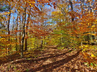
![]()
![]()
![]()
![]()
![]() On Sunday, October 20th I wanted to get in a hike somewhere away from Livingston Manor as I had coverage for ambulances calls until 6:00 PM. I wanted to see how our new puppy Sheena would do on a longer hike than the figure 8 on Round Top. The day was beautiful, sunny, and unseasonably warm with temperatures in the low 70's. I asked Cindy if she would like to hike to Frick Pond but she declined. I put on my Mammut long-sleeved crew top with a short-sleeved baselayer. I wore my Railriders hiking pants which are expensive but last along time and have features like deep pockets and a generous cut which I really like. The pants have Velcro closures at the ankles. I decided to put on my Keen Durand hiking boots which fit well and are newer than what I have been wearing. I added a new pair of Xstance insoles in an effort to find the best support and cushioning for my feet. These insoles have shock absorbing gel pads, TPU arch support, and memory foam cushioning all wrapped in a breathable fabric. The insoles have been hyped by their manufacturer and they really do seem to deliver. I decided not to take poles as I would have Sheena on her leash and the hike is short. It was warm enough that I felt I didn't need a jacket. I put my gear in the back and Sheena in the backseat and headed out the DeBruce Road at 1:30 PM. Sheena seemed less apprehensive about the car ride and laid down in the back seat. After 6 miles, at Mongaup Pond Road, I turned left and continued to follow the road bearing left onto Beech Mountain Road at the fork. When we arrived at the trailhead, we found three cars parked in the small lot but none in the large lot. I pulled into a spot available in the smaller lot. Sheena was acting as if she couldn't wait to get on the trail which I hoped was a good sign. When I did let her out, she started to pull on the leash and headed for the woods road toward Frick Pond. The temperature was 68 degrees and the skies were bright and sunny with a few puffy white clouds. I grabbed my pack and lock the car.
On Sunday, October 20th I wanted to get in a hike somewhere away from Livingston Manor as I had coverage for ambulances calls until 6:00 PM. I wanted to see how our new puppy Sheena would do on a longer hike than the figure 8 on Round Top. The day was beautiful, sunny, and unseasonably warm with temperatures in the low 70's. I asked Cindy if she would like to hike to Frick Pond but she declined. I put on my Mammut long-sleeved crew top with a short-sleeved baselayer. I wore my Railriders hiking pants which are expensive but last along time and have features like deep pockets and a generous cut which I really like. The pants have Velcro closures at the ankles. I decided to put on my Keen Durand hiking boots which fit well and are newer than what I have been wearing. I added a new pair of Xstance insoles in an effort to find the best support and cushioning for my feet. These insoles have shock absorbing gel pads, TPU arch support, and memory foam cushioning all wrapped in a breathable fabric. The insoles have been hyped by their manufacturer and they really do seem to deliver. I decided not to take poles as I would have Sheena on her leash and the hike is short. It was warm enough that I felt I didn't need a jacket. I put my gear in the back and Sheena in the backseat and headed out the DeBruce Road at 1:30 PM. Sheena seemed less apprehensive about the car ride and laid down in the back seat. After 6 miles, at Mongaup Pond Road, I turned left and continued to follow the road bearing left onto Beech Mountain Road at the fork. When we arrived at the trailhead, we found three cars parked in the small lot but none in the large lot. I pulled into a spot available in the smaller lot. Sheena was acting as if she couldn't wait to get on the trail which I hoped was a good sign. When I did let her out, she started to pull on the leash and headed for the woods road toward Frick Pond. The temperature was 68 degrees and the skies were bright and sunny with a few puffy white clouds. I grabbed my pack and lock the car.
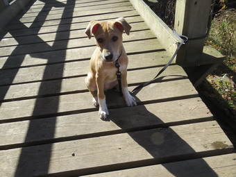 We set off on the woods roads that leads to the register on the Quick Lake Trail. I almost immediately stopped and took out my camera to take some shots of the leaves along the woods road. At the register, we continued straight ahead toward Frick Pond on the Quick Lake Trail. The trail was almost dry with only a few damp spots. Even the small streams that usually cross the trail were almost dry. We continued along the trail and I checked that the Lobdell Memorial was still standing. As we approached Gravestone Junction we could hear voices and saw hikers approaching from the Loggers Loop. We met a group of 4 hikers and their dog at the junction. The dog was not on a leash but fortunately was friendly. The two dogs got along and Sheena loves people. Everyone thought she was cute and asked her breed. I said she was a Feist/Cur cross and went on the explain they are southern hunting breeds. We stayed to the left to follow the Quick Lake Trail down to the bridge at the outlet end of Frick Pond. There were a few muddy spots along the way which we crossed easily. We stopped at the bridge and I decided to take a few shots even though the leaves were past prime. The water level in the pond was as low as I have see it with almost no water flowing in the outlet stream. I tried to take some pictures of Sheena on the bridge but she kept moving around. We continued across the bridge and around the west side of the pond crossing another muddy spot with no problem. I noticed that the two bridges on the west side of the pond needed some repair work before they would have to be replaced. At the junction with the Big Rock Trail, we turned right on the Big Rock Trail and continued along the west side of the wetlands at the head of the pond. We came to the wooden walkways and I decided to take some pictures. The bright sunlight was at the wrong angle and getting good shots with the right exposure was difficult. The wooden walkways can the very slippery when wet but on this day they were very dry. These walkways also need repair, a fact we have mentioned to both the DEC and the NYNJTC. Repairing them now will be much easier than replacing them later!
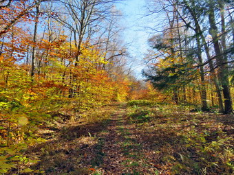 We walked through the spruce tunnel and across two bridges. I looked to see if there were some photographic opportunities and decided to take a few shots before moving on. There were still a few isolated trees with some color. We continued in the trail around the north end of the pond. The north end of the pond is usually very wet and muddy but there were only a few spots. We came to one medium sized trunk that had blown down across the trail. I am no conger clearing trails after being "fired" by the NYNJTC. I hope whoever is responsible for the arils will clear this blowdown. When we arrived at Times Square, we turned right to complete the loop around Frick Pond on the Logger's Loop. This trail is a very gentle climb and then a slight descent to Gravestone Junction to complete the loop. Sheena was behaving very nicely and was pulling me along most of the time. Every now and then she had to stop and use her nose but those times did not last long. We kept a steady pace down and then up the hill. There were a few wet spots along the way but they were easy to avoid. As we came to the primitive campsites and privy, there were two more trunks across the trail. I was surprised that we new maintainers had not cleared these obstacles to make hiking easier!. We were soon back at Gravestone Junction where we turned left. We walked the Quick Lake Trail back to the trail register abed then the woods road to the car. It was 2:50 PM and we had hiked the 2.3 miles in 1 hour and 5 minutes with an elevation gain of 210 feet. I thought this was a good pace with a new puppy and the time spent taking pictures. Sheena did not seemed tired but did lay down on the back seat of the car
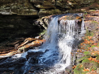 I drove back to the intersection of Beech Mountain Road and Mongaup Pond Road fully intending to head home. Just before I turned right, I got the idea that we should visit Mongaup Falls. I turned left and immediately parked in one of the two spots in the small parking area on the right. When I let Sheena out of the car she seemed very enthusiastic about hiking some more. I shoulder my pack and we started out walking on the road at 3:00 PM. We walked back toward the intersection and turned right on what used to be a town road. We walked down what was now a woods road to the bridge across the outlet stream for Mongaup Pond. I could see the water level was low in the stream. We turned right and walked along the bank of the stream. Sheena seemed very interesting in the running water. When we came to the falls, I could see the water level was as low as I had ever seen it but I decided to take some shots anyway. I leashed Sheena to a tree amd got out my camera. I walked down to some rocks that jut out into the stream. Taking pictures was not easy because the sunlight was bright and at the wrong angle. I took some shots anyway and the walked downstream. I worked my way down the rocks along the edge of the main falls without a problem. These rocks are often wet and slippery but were very dry on this day. I stopped and took some pictures of the falls from the side and then walked down to the bottom of the falls. Trying to take good shots from this angle was again difficult due to the sunlight. After I finished my photography, I walked back up the rocks to Sheena who was sitting quietly. I put my camera away, shouldered my pack, amd we headed back to the bridge. To my surprise Sheena turned right and headed up the hill! I decided to follower her. I am convinced she knew the way back to the car but just wanted to hike more in the warm weather. We walked up the hill on the woods road until the trail split. I decided we had hiked far enough and turned around to return to the car. Sheena did not object but wanted to run down the hill. I tried to match her pace but the slippery leaves covering round rocks made me slow her pace. This time we walked across the bridge and up the woods road. We turned right at the top of the hill and walked back to the car. It was 3:35 PM and I estimated we had walked another mile or so. This time Sheena stretched out on the back seat for the ride back to town.
![]()
![]()
![]()
![]() On Thursday, October 17th I planned to get out for a hike on Round Top with my new dog Sheena. She is a Feist-Cur cross which are actual types of dogs used on farms and for hunting in the south. She probably won't get to be more than 30 pounds which makes Cindy happy although I would have preferred a larger dog. She was born the day after Sheila died. I started to get ready to hike at 11:45 aM with the temperature at 60 degrees on the back porch. I had panned to get started earlier as I had a lot of work to do during the day but we had four ambulance calls overnight. The pager sounded again at 8:30 AM which kept me from hiking until the very late morning. I got dressed in my Mammut crew top with a short-sleeved baselayer as I did not want to wear a jacket and it was beginning to get cool out. I wore my Railriders hiking pants which are expensive but last along time and have features like deep pockets and a generous cut which I really like. The pants have Velcro closures at the ankles. I decided to put on my Keen Durand hiking boots which I ordered a half size larger than the previous pair. These shoes fit well out of the box but get much tighter when I add a decent insole. Without the third party insole, by feet hurt from the lack of support. I added a new pair of Xstance insoles in an effort to find the best support and cushioning for my feet. These insoles have shock absorbing gel pads, TPU arch support, and memory foam cushioning all wrapped in a breathable fabric. The insoles have been hyped by their manufacturer and they really do seem to deliver. I decided not to take any poles as the walk would be short and I would be holding Sheena's leash. At 12:00 PM I put Sheena on her leash and we walked out the door to start the hike. We headed down the driveway and toward the street. Sheena has gotten used to walking on her leash to the end of the drive but usually gets nervous as we get near the road. This time she walked to the edge of the street and waited until O said "OL" and then she crossed. She walked across the field by the church leading me toward the back of the church. She turned left a headed up the ascent of the steepest hill behind the church. Sheena had no problem walking up the hill except for the fact that she likes to stop and sniff very frequently. The hill is short but gets the circulation pumping and is the steepest and longest climb on the "trail." Not having poles made it more of a challenge. We did not stop on the way to the top of the hill but set a fast pace. I could feel that I had not been hiking in a while but Sheena is now bigger and her pull on the leash is signficant. At the top we paused for a minute so I could look around at the hills that surround the hamlet of Livingston Manor. The skies were blue with a few white clouds and bright sunshine. Most of the leaves were gone from the trees and the scene was definitely 'past peak". Sheena was eager to enter the woods on the trail and hopped right up the steps. The trail was damp from the recent showers and the temperature under the trees seemed cooler than in the sun.
On Thursday, October 17th I planned to get out for a hike on Round Top with my new dog Sheena. She is a Feist-Cur cross which are actual types of dogs used on farms and for hunting in the south. She probably won't get to be more than 30 pounds which makes Cindy happy although I would have preferred a larger dog. She was born the day after Sheila died. I started to get ready to hike at 11:45 aM with the temperature at 60 degrees on the back porch. I had panned to get started earlier as I had a lot of work to do during the day but we had four ambulance calls overnight. The pager sounded again at 8:30 AM which kept me from hiking until the very late morning. I got dressed in my Mammut crew top with a short-sleeved baselayer as I did not want to wear a jacket and it was beginning to get cool out. I wore my Railriders hiking pants which are expensive but last along time and have features like deep pockets and a generous cut which I really like. The pants have Velcro closures at the ankles. I decided to put on my Keen Durand hiking boots which I ordered a half size larger than the previous pair. These shoes fit well out of the box but get much tighter when I add a decent insole. Without the third party insole, by feet hurt from the lack of support. I added a new pair of Xstance insoles in an effort to find the best support and cushioning for my feet. These insoles have shock absorbing gel pads, TPU arch support, and memory foam cushioning all wrapped in a breathable fabric. The insoles have been hyped by their manufacturer and they really do seem to deliver. I decided not to take any poles as the walk would be short and I would be holding Sheena's leash. At 12:00 PM I put Sheena on her leash and we walked out the door to start the hike. We headed down the driveway and toward the street. Sheena has gotten used to walking on her leash to the end of the drive but usually gets nervous as we get near the road. This time she walked to the edge of the street and waited until O said "OL" and then she crossed. She walked across the field by the church leading me toward the back of the church. She turned left a headed up the ascent of the steepest hill behind the church. Sheena had no problem walking up the hill except for the fact that she likes to stop and sniff very frequently. The hill is short but gets the circulation pumping and is the steepest and longest climb on the "trail." Not having poles made it more of a challenge. We did not stop on the way to the top of the hill but set a fast pace. I could feel that I had not been hiking in a while but Sheena is now bigger and her pull on the leash is signficant. At the top we paused for a minute so I could look around at the hills that surround the hamlet of Livingston Manor. The skies were blue with a few white clouds and bright sunshine. Most of the leaves were gone from the trees and the scene was definitely 'past peak". Sheena was eager to enter the woods on the trail and hopped right up the steps. The trail was damp from the recent showers and the temperature under the trees seemed cooler than in the sun.
At the first trail junction, I followed Sheena as she turned right to head up the woods road which is the shallower approach to the trail system. Sheena seemed to have no problem leading me by pulling on her leash. At the end of the woods road, she turned left on the yellow trail and continued uphill and I followed. I picked up a few branches along the way but for the most part the trail was clear. At the first junction with the blue trail we turned left to walk along the base of Round Top. Sheena always likes to run along this part of the trail. She will strain at her leash if I don't at least jog behind her so that's what I did. When we arrived at the junction with the blue trail, we turned right and started up the hill. Sheena turned right on the switchback without my prompting and I followed her. We haven't been over the trails too many times so I don't know if she was following a scent track just got lucky. We walked on the switchback out into the forest and then back to the main blue trail. We turned right and walked on the blue trail over the highest point. As we started down the other side, Sheena wanted to go at a pace I could not match and keep my balance at the same time. I slowed Sheena down by pulling on her leash and saying "Don't pull" and "With" which have both started to work. When we got to the trail junction with the yellow trail, we turned right and again followed the yellow along the base of Round Top. This time when we came to the junction with the blue trail, we stayed to the left and followed the yellow trail downhill. We came to the "Sitting Rock" where I wanted to take a break but Sheena did not agree so we continued on the trail. We passed through the ferns which were now brown and continued to the lookout. From the upper lookout I could a single male hiker looking out from the viewpoint. As we passed I said something to Sheena and the hiker turned and said "Hello". I returned his greeting as we continued won the yellow trail. Sheena and I continued down the hill toward the first trail junction. Sheena again wanted to descend at top speed. At the first junction we continued straight out to the trailhead. I had hoped to do at least another small loop but this had been our best hike yet and I did not want to press my luck. I am hoping to be able to let her off her leash soon perhaps with the help of an electronic collar. I think this will benefit both of us but I have to be sure Sheena will come back when called. We turned right and walked down the road to the back of the church. Sheena is still shy near roads but she crossed the field by the church and, with a little encouragement, crossed the street to our driveway. We were back at the house by 12:35 PM and it had taken us 35 minutes to hike a little more than a mile. Sheena drank a lot of water and then laid down by me for a long nap.
![]()
![]()
![]()
![]() On Saturday, October 12th I planned to get out for a hike on Round Top with my new dog Sheena. She is a Feist-Cur cross which are actual types of dogs used on farms and for hunting in the south. She probably won't get to be more than 30 pounds which makes Cindy happy although I would have preferred a larger dog. She was born the day after Sheila died. I started to get ready to hike at 12:15 PM with the temperature at 66 degrees on the back porch. I got dressed in my Mammut crew top with no baselayer as I did not want to wear a jacket and it was beginning to get cool out. I wore my Railriders hiking pants which are expensive but last along time and have features like deep pockets and a generous cut which I really like. The pants have Velcro closures at the ankles. I decided to put on my Keen Durand hiking boots which I ordered a half size larger than the previous pair. These shoes fit well out of the box but get much tighter when I add a decent insole. Without the third party insole, by feet hurt from the lack of support. I added a new pair of Xstance insoles in an effort to find the best support and cushioning for my feet. These insoles have shock absorbing gel pads, TPU arch support, and memory foam cushioning all wrapped in a breathable fabric. The insoles have been hyped by their manufacturer and they really do seem to deliver. I decided not to take any poles as the walk would be short and I would be holding Sheena's leash. At 12:30 PM I put Sheena on her leash and we walked out the door to start the hike. We headed down the driveway and toward the street. Sheena has gotten used to walking on her leash to the end of the drive but gets nervous as we get near the road. This time I had to carry her across the street to the field by the church. We walked to the back of the church and began the ascent of the steepest hill behind the church. Sheena had no problem walking up the hill except for the fact that she likes to stop and sniff very frequently. The hill is short but gets the circulation pumping and is the steepest and longest climb on the "trail." Not having poles made it more of a challenge. We did not stop on the way to the top of the hill but set a fast pace. I could feel that I had not been hiking in a while but Sheena is now bigger and her pull on the leash is signficant. At the top we paused for a minute so I could look around at the hills that surround the hamlet of Livingston Manor. The skies were blue with a few white clouds and bright sunshine. Sheena was eager to enter the woods on the trail and hopped right up the steps. The trail was dry and the temperature under the trees seemed cooler than in the sun.
On Saturday, October 12th I planned to get out for a hike on Round Top with my new dog Sheena. She is a Feist-Cur cross which are actual types of dogs used on farms and for hunting in the south. She probably won't get to be more than 30 pounds which makes Cindy happy although I would have preferred a larger dog. She was born the day after Sheila died. I started to get ready to hike at 12:15 PM with the temperature at 66 degrees on the back porch. I got dressed in my Mammut crew top with no baselayer as I did not want to wear a jacket and it was beginning to get cool out. I wore my Railriders hiking pants which are expensive but last along time and have features like deep pockets and a generous cut which I really like. The pants have Velcro closures at the ankles. I decided to put on my Keen Durand hiking boots which I ordered a half size larger than the previous pair. These shoes fit well out of the box but get much tighter when I add a decent insole. Without the third party insole, by feet hurt from the lack of support. I added a new pair of Xstance insoles in an effort to find the best support and cushioning for my feet. These insoles have shock absorbing gel pads, TPU arch support, and memory foam cushioning all wrapped in a breathable fabric. The insoles have been hyped by their manufacturer and they really do seem to deliver. I decided not to take any poles as the walk would be short and I would be holding Sheena's leash. At 12:30 PM I put Sheena on her leash and we walked out the door to start the hike. We headed down the driveway and toward the street. Sheena has gotten used to walking on her leash to the end of the drive but gets nervous as we get near the road. This time I had to carry her across the street to the field by the church. We walked to the back of the church and began the ascent of the steepest hill behind the church. Sheena had no problem walking up the hill except for the fact that she likes to stop and sniff very frequently. The hill is short but gets the circulation pumping and is the steepest and longest climb on the "trail." Not having poles made it more of a challenge. We did not stop on the way to the top of the hill but set a fast pace. I could feel that I had not been hiking in a while but Sheena is now bigger and her pull on the leash is signficant. At the top we paused for a minute so I could look around at the hills that surround the hamlet of Livingston Manor. The skies were blue with a few white clouds and bright sunshine. Sheena was eager to enter the woods on the trail and hopped right up the steps. The trail was dry and the temperature under the trees seemed cooler than in the sun.
At the first trail junction, I followed Sheena as she turned right to head up the woods road which is the shallower approach to the trail system. Sheena seemed to have no problem leading me by pulling on her leash. We turned left on the yellow trail and continued uphill. I picked up a few branches along the way but for the most part the trail was clear. At the first junction with the blue trail we turned left to walk along the base of Round Top. Sheena always likes to run along this part of the trail. She will strain at her leash if I don't at least jog behind her so that's what I did. When we arrived at the junction with the blue trail, we turned right and started up the hill. Sheena turned right on the switchback and I followed her. We haven't been over the trails too many times so I don't know if she was following a scent track just got lucky. We walked on the switchback out into the forest and then back to the main blue trail. We turned right and walked on the blue trail over the highest point. As we started down the other side, Sheena wanted to go at a pace I could not arch and keep my balance at the same time. I slowed Sheena down by pulling on her leash but that did not deter her much. When we got to the trail junction with the yellow trail, we turned right and again followed the yellow along the base of Round Top. This time when we came to the junction with the blue trail, we stayed to the left and followed the yellow trail downhill. We came to the "sitting Rock" where I wanted to take a break but Sheena did not agree so we continued on the trail. We passed through the ferns which were now brown and continued to the lookout. From the upper lookout I could see a couple on the viewpoint below accompanied by a videographer. When they took a break, I explained to them that they were standing on a rock shelf with a "cave" beneath. I also described the other "caves" in the area formed by overhanging rock sliding over gaps in the rocks. They seemed interested and thanked me for the information. Sheena and I continued down the hill toward the first trail junction. Sheena again wanted to descend at top speed. At the first junction we continued straight out to the trailhead. I had hoped to do at least another small loop but Sheena gets bored easily. I am hoping to be able to let her off her leash soon perhaps with the help of an electronic collar. I think this will benefit both of us but I have to be sure Sheena will come back when called. We turned right and walked down the road to the back of the church. Sheena is still shy near roads but she crossed the field by the church and, with a little encouragement, crossed the street to our driveway. We were back at the house by 1:10 PM and it had taken us 40 minutes to hike a little more than a mile. Sheena drank a lot of water and then laid down by me for a long nap.
![]() On Wednesday, October 9th I planned to go to Walnut Mountain to mark the cross country course with white paint for a race at 4:15 PM. I wanted to get there around 1:30 to have plenty of time to walk and mark the course. Since the course is a point to point course, I would have to walk the entire course to mark it. I had laid out the course six years ago and made sure it was exactly 5K which translates to 16,404.2 feet. For the last few years we returned to our course on school grounds. This course will be unavailable next week because of some work on the school grounds. I began to get ready at 12:30 PM with the temperatures at 68 degrees with a slight breeze blowing. I got dressed in my White Sierra light crew top with no baselayer. I wore an older pair of hiking pants so that I did not get paint on my Railriders hiking pants. I decided to put on my Zamberlain low hiking shoes because they are easier on my feet for jogging the course. I made sure I had all the paperwork for the race that day and the recording stopwatch we use time the races. I got everything I needed in the car and at 1:00 PM I drove out our driveway and got on the Quickway east toward Liberty. I needed to pick up the paint at Liberty HS so I got off at exit 99 and took buckley Street up the hill to the high school. I picked up tree cans of paint and visited a few people. As usually happens, I got involved in some conversations which delayed my arrival at the course. I drove away from the high school at took West Street out to Route 52. A left on Eagle Drive and a left on West Lake Street brought me to Route 55. I turned right a went a short distance before turning right on Walnut Mountain Road. I pulled into the main parking area at 1:45 PM. Several other cars were parked and some kids were using the playground equipment. I got out a can of white paint and headed toward the starting line below the fields. I decided not to paint the starting line to make sure I got through the lower loop on one can of paint.
On Wednesday, October 9th I planned to go to Walnut Mountain to mark the cross country course with white paint for a race at 4:15 PM. I wanted to get there around 1:30 to have plenty of time to walk and mark the course. Since the course is a point to point course, I would have to walk the entire course to mark it. I had laid out the course six years ago and made sure it was exactly 5K which translates to 16,404.2 feet. For the last few years we returned to our course on school grounds. This course will be unavailable next week because of some work on the school grounds. I began to get ready at 12:30 PM with the temperatures at 68 degrees with a slight breeze blowing. I got dressed in my White Sierra light crew top with no baselayer. I wore an older pair of hiking pants so that I did not get paint on my Railriders hiking pants. I decided to put on my Zamberlain low hiking shoes because they are easier on my feet for jogging the course. I made sure I had all the paperwork for the race that day and the recording stopwatch we use time the races. I got everything I needed in the car and at 1:00 PM I drove out our driveway and got on the Quickway east toward Liberty. I needed to pick up the paint at Liberty HS so I got off at exit 99 and took buckley Street up the hill to the high school. I picked up tree cans of paint and visited a few people. As usually happens, I got involved in some conversations which delayed my arrival at the course. I drove away from the high school at took West Street out to Route 52. A left on Eagle Drive and a left on West Lake Street brought me to Route 55. I turned right a went a short distance before turning right on Walnut Mountain Road. I pulled into the main parking area at 1:45 PM. Several other cars were parked and some kids were using the playground equipment. I got out a can of white paint and headed toward the starting line below the fields. I decided not to paint the starting line to make sure I got through the lower loop on one can of paint.
The XC course starts along the Walnut Loop East Trail with a wide-open grassy area that allows a fair start. After about .1 miles it turns slightly to the right and enters the woods on a wide but rocky carriage road. My method in painting is to mark all the turns with a prominent arrow. I also use a straight arrow near any potential turns the runners should avoid. Finally, I put straight arrows on long straight sections of trail to let the runners know they are on the course. Where the course enters the woods, I placed an arrow indicating a turn. The leaves cause a problem with placing arrows. Painting on top of the leaves means they can blow away. Clearing them away leaves a dry and dusty area that really absorbs the paint. The course continues downhill for about .5 miles when it turns 90 degrees to the left on the Walnut Loop North Trail. I put a couple of straight arrows along this section and an arrow indicating a left turn where the course turns 90 degrees. This section of trail is grassy and immediately begins a gentle climb until it transitions back to gravel at .7 miles and begins a steeper climb. I painted a few arrows along the way especially where single track bike trails cross. At .8 miles the course turns left on Vista Way which is a narrow trail rather than a carriageway. I placed a straight arrow up the hill and one that clearly showed the turn to the left. I followed Vista way as it headed back toward the parking area crossing a small bridge over what is soemtimes a stream. I placed some arrows along the way and a huge arrow where the trail turns and heads across the bridge. From the bridge the course begins a slight ascent until it breaks out of the trees at the parking lot. I painted some straight arrows along the way especially where there are trails which the runners should not use. The course follows a fence line back toward the grove of trees that surrounds the pavilion. I painted arrows aright along the fence and an arrow near the park building that shows a turn to the right and through the grove over a small culvert. The course then turns right up the carriageway following the Mountain Overlook Trail and this is where the real work for the runners begins. The carriage path is rocky and mostly up hill from 1.25 miles to 1.8 miles although the course does level some and even descends a bit at 1.6 miles where it joins the Walnut Loop North Trail. I went to my car and got a new can of paint as the one I had was almost empty. At this point the bus from Liberty arrived and I spoke to their coach. I told her I had marked the first part of the course and was headed up the mountain to mark the rest. She thanked me and said she would take her runners around the course. I painted the turn arrow after the grove and then continued to paint arrows indicating turns in the main carriageway and places where the runners should not turn. At 1.8 miles the course turns sharply to the left and ascends an unnamed trail. I did my best to paint a turn arrow before the turn and another large one at the turn. The trail is narrow with plenty of rocks and roots. This section is only .15 miles long but ascends at a 17% grade to the Sunset Trail. I painted a few arrows especially where other trails and track cross this trail. I also added some paint to the roots and rocks that were in the trail.
At 2 miles the course turns right on the Sunset Trail which is another wide carriageway which allows runners to pass each other. Before and at the turn I painted arrows indicating a turn to the right. The surface here is smooth and firm and it does ascend a little until it breaks out into an open area which has a nice lookout to the right. I painted a few arrows along the way although there were no turns. Approaching the lookout, the Mountain House Trail turns left but the runners do not so I painted a big arrow straight ahead. At the left turn onto the Mountain Overlook Trail, I painted a prominent arrow to show the turn to the runners. The runners will not get to see the view from the lookout as they make the sharp left at 2.3 miles on the Mountain Overlook Trail. The Mountain Overlook Trail is a wide but rocky carriageway that begin the runners descent off the mountain. From 2.3 miles to 2.7 miles the runners are headed downhill on the Mountain Overlook Trail. I painted one set of arrows straight ahead at the beginning of the trail as another trail turns to the right. Further along the course once turned right into a field but this section had some dangerous spots and I noticed it was not maintained. Now the course simply continues on the Mountain Overlook Trail. I painted some straight arrows here to make sure the runners continued straight ahead without turning. At 2.7 miles the runners turn right to stay on the Mountain Overlook Trail back to the grove of trees near the pavilion. I painted arrows on the right side of the trail going down to indicate turns and places where the runners should not turn. This section of trail has an overlap for runners coming up the hill and those going down. The runners pass through a gate and then veer right to head to the finish line on the Walnut Loop South Trail. I painted the arrows clearly indicate the direction the runners should tale. After turning to the right near the playground, the runners enter a final bit of woods. From there to the finish there are no turns but I placed some arrows to let the runners know they were almost done. When they come out of the woods, they pass through an old red shale quarry and sprint to the finish line near the disc golf course. When I reached the finish line, I had enough paint to paint a thick line to show the finish of the race. I headed back to the parking area and walked down to the starting area where I painted a wide line ling enough to give everyone a fair start. I was 3:00 PM when I finished and I just had to wait for the runners from the other schools to arrive.
As time passed, I began to get a little nervous that teams were not arriving as early as I expected. Since this is a point to point course, the runners have to walk or jog the entire course to know what it looks like and where the turns occur. Eldred was the first to arrive a little after 3:15 PM and I knew they would be able to do the whole course. It wasn't until after 3:30 PM that Homestead was at the park followed shortly by Livingston Manor/Rosoce. I explained to the coaches that we could delay to 4:30 PM but that would mean they would probably not be able to walk the entire course. The coaches understood and decided to walk the second half. I gave all the coaches a packet with maps and score sheets and sent them off. All the schools except for Liberty had brought modified runners and the modified coaches took my suggestion of running the first half of the course and to the finish. The liberty runners returned from their walk of the course and seemed to be suitably impressed by the hills! At 4:30 PM I summoned all the runners to the start line. The Liberty coach took a moment to honor two senior runners, Braeden Clarke and Konnar Williams. Just after 4:30 PM, I called the boys and girls varisty runners to the line, gave the instructions and sounded the horn. We waited about 5 minutes and lined up the modified runners and sent them off. My wide, who was timing, and I walked back up to the parking area to await the runners coming through after the first part of the race. As the runners appeared it was clear that Livingston Manor/Rosoce boys had the race under control. Runners continued to pass by and head up the hill. Soon the modified runners appeared and passed straight through the grove to the finish line. The modified coaches were handling the timing. In a few more minutes, Cindy and I headed along the trail to the finish line to be prepared for the end of the varsity race. As the varsity runners crossed the line, Cindy hit the button on the stopwatch and called out the times. Our athletic director helped by handing each runner a card with their finish number. I wrote down the school and time. I either knew the runners' names or was able to ask the coaches. When all the runners were done, I pronounced the race a success. This opinion was supported by the coaches, runners and numerous spectators.
![]()
![]()
![]()
![]() On Monday, October 7th I planned to get out for a hike on Round Top with my new dog Sheena. She is a Feist-Cur cross which are actual types of dogs used on farms and for hunting in the south. She probably won't get to be more than 30 pounds which makes Cindy happy although I would have preferred a larger dog. She was born the day after Sheila died. I started to get ready to hike at 1:45 PM with the temperature at 62 degrees on the back porch. I got dressed in my Mammut crew top with no baselayer as I did not want to wear a jacket and it was beginning to get cool out. I wore my Railriders hiking pants which are expensive but last along time and have features like deep pockets and a generous cut which I really like. The pants have Velcro closures at the ankles. I decided to put on my Keen Durand hiking boots which I ordered a half size larger than the previous pair. These shoes fit well out of the box but get much tighter when I add a decent insole. Without the third party insole, by feet hurt from the lack of support. I added a new pair of Xstance insoles in an effort to find the best support and cushioning for my feet. These insoles have shock absorbing gel pads, TPU arch support, and memory foam cushioning all wrapped in a breathable fabric. The insoles have been hyped by their manufacturer and they really do seem to deliver. I decided not to take any poles as the walk would be short and I would be holding Sheena's leash. At 2:00 PM I put Sheena on her leash and we walked out the door to start the hike. We headed down the driveway and toward the street. Sheena has gotten used to walking on her leash to the end of the drive but gets nervous as we get near the road. This time I had to carry her across the street to the field by the church. We walked to the back of the church and began the ascent of the steepest hill behind the church. Sheena had no problem walking up the hill except for the fact that she likes to stop and sniff very frequently. The hill is short but gets the circulation pumping and is the steepest and longest climb on the "trail." Not having poles made it more of a challenge. We did not stop on the way to the top of the hill but set a fast pace. I could feel that I had not been hiking in a while but Sheena is now bigger and her pull on the leash is signficant. At the top we paused for a minute so I could look around at the hills that surround the hamlet of Livingston Manor. The skies were blue with a few white clouds and bright sunshine. Sheena was eager to enter the woods on the trail and hopped right up the steps. The trail was dry and the temperature under the trees seemed cooler than in the sun.
On Monday, October 7th I planned to get out for a hike on Round Top with my new dog Sheena. She is a Feist-Cur cross which are actual types of dogs used on farms and for hunting in the south. She probably won't get to be more than 30 pounds which makes Cindy happy although I would have preferred a larger dog. She was born the day after Sheila died. I started to get ready to hike at 1:45 PM with the temperature at 62 degrees on the back porch. I got dressed in my Mammut crew top with no baselayer as I did not want to wear a jacket and it was beginning to get cool out. I wore my Railriders hiking pants which are expensive but last along time and have features like deep pockets and a generous cut which I really like. The pants have Velcro closures at the ankles. I decided to put on my Keen Durand hiking boots which I ordered a half size larger than the previous pair. These shoes fit well out of the box but get much tighter when I add a decent insole. Without the third party insole, by feet hurt from the lack of support. I added a new pair of Xstance insoles in an effort to find the best support and cushioning for my feet. These insoles have shock absorbing gel pads, TPU arch support, and memory foam cushioning all wrapped in a breathable fabric. The insoles have been hyped by their manufacturer and they really do seem to deliver. I decided not to take any poles as the walk would be short and I would be holding Sheena's leash. At 2:00 PM I put Sheena on her leash and we walked out the door to start the hike. We headed down the driveway and toward the street. Sheena has gotten used to walking on her leash to the end of the drive but gets nervous as we get near the road. This time I had to carry her across the street to the field by the church. We walked to the back of the church and began the ascent of the steepest hill behind the church. Sheena had no problem walking up the hill except for the fact that she likes to stop and sniff very frequently. The hill is short but gets the circulation pumping and is the steepest and longest climb on the "trail." Not having poles made it more of a challenge. We did not stop on the way to the top of the hill but set a fast pace. I could feel that I had not been hiking in a while but Sheena is now bigger and her pull on the leash is signficant. At the top we paused for a minute so I could look around at the hills that surround the hamlet of Livingston Manor. The skies were blue with a few white clouds and bright sunshine. Sheena was eager to enter the woods on the trail and hopped right up the steps. The trail was dry and the temperature under the trees seemed cooler than in the sun.
At the first trail junction, we continued straight up the hill with Sheena leading the way on her leash. When we reached the top of the hill, we followed the yellow trail as it turned right. The trails were covered with multicolored leaves but many were brown. The leaves on the trees were becoming fewer and fewer and the colors were still very muted. We walked uphill through the field of ferns that was rapidly turning brown with the nighttime temperatures in the low 30's. When we reached the "sitting rock", we stopped for a moment so that I could sit. The woods would be quiet except for the traffic on the Quickway. I would have remained for a few minutes but Sheena was not interested in stopping. We continued on the yellow trail up a small hill to the junction with the blue trail to the summit. I decided we would do a figure 8 so we turned right on the yellow trail. We followed the yellow trail along the base of Round Top with Sheena wanting to run ahead. At the next junction with the blue trail, we turned left and headed up toward the summit. Sheena showed no sign of slowing down and helped pull me quickly up the hill. We passed over the highest point on the trail and started down the other side. We passed by the white crossover trail but almost immediately turned left on the switchback in the blue trail. We walked out into the woods and turned almost 180 degrees to head back to the main blue trail. On the main blue trail we turned left and again walked on the yellow trail along the base of Round Top. At the next junction with the blue trail we turned right and headed down the yellow trail. Where the trail meets the woods road we turned right and continue downhill to the first trail junction. We turned left and walked out to the trailhead. We turned right and walked down the cemetery hill to the church parking lot. We walked across the field by the church with Sheena shying a bit whenever a car passed. She did walk across the road after I looked both ways. It was 2:35 PM and it had taken us 35 minutes to hike a little more than a mile. Sheena drank a lot of water and then laid down by me for a long nap.
![]() On Friday, October 4th I planned to go back to Walnut Mountain to walk the cross country course with Liberty XC Coach Samantha Abplanalp. I wanted her to know the course and wanted to be sure she felt it was ready for our Wednesday race. We agreed to meet at the main parking lot at Walnut Mountain Park at 4:15 PM. I had just walked the course and did some maintain the day before but was anxious to walk it at a faster pace. I had laid out the course six years ago and made sure it was exactly 5K which translates to 16,404.2 feet. For the last few years we returned to our course on school grounds. This course will be unavailable next week because of some work on the school grounds. I began to get ready at 3:30 PM with the temperatures at 70 degrees with a slight breeze blowing. I got dressed in my White Sierra light crew top with no baselayer. I wore my Railriders hiking pants which are expensive but last along time and have features like deep pockets and a generous cut which I really like. The pants have Velcro closures at the ankles. I decided to put on my Keen Durand hiking boots which I ordered a half size larger than the previous pair. These shoes fit well out of the box but get much tighter when I add a decent insole. Without the third party insole, by feet hurt from the lack of support. I added a new pair of Xstance insoles in an effort to find the best support and cushioning for my feet. These insoles have shock absorbing gel pads, TPU arch support, and memory foam cushioning all wrapped in a breathable fabric. The insoles have been hyped by their manufacturer and they really do seem to deliver. I decided to take my Leki MicroVario poles as they are light and easy to use. I put my Silky Sugowaza saw in my pack and made sure I had my Garmin GPSMAP 64st gps unit with me to check the length of the cross country course. I got my gear in the car and at 3:50 PM I drove out our driveway and got on the Quickway east toward Liberty. I got off at exit 100 and took Lake Street up the hill to Route 55. I drove a short distance and turned right on Walnut Mountain Road. I pulled into the main parking area at 4:05 PM. Several other cars were parked and some kids were using the playground equipment. I took the time to snap some shots of the leaves and the clouds. Samantha arrived a few minutes later. I put on my pack and we headed down to the XC start line below the baseball field. I set my GPS unit and we began our walk at 4:20 PM. I was anxious to see what Samantha thought about the course.
On Friday, October 4th I planned to go back to Walnut Mountain to walk the cross country course with Liberty XC Coach Samantha Abplanalp. I wanted her to know the course and wanted to be sure she felt it was ready for our Wednesday race. We agreed to meet at the main parking lot at Walnut Mountain Park at 4:15 PM. I had just walked the course and did some maintain the day before but was anxious to walk it at a faster pace. I had laid out the course six years ago and made sure it was exactly 5K which translates to 16,404.2 feet. For the last few years we returned to our course on school grounds. This course will be unavailable next week because of some work on the school grounds. I began to get ready at 3:30 PM with the temperatures at 70 degrees with a slight breeze blowing. I got dressed in my White Sierra light crew top with no baselayer. I wore my Railriders hiking pants which are expensive but last along time and have features like deep pockets and a generous cut which I really like. The pants have Velcro closures at the ankles. I decided to put on my Keen Durand hiking boots which I ordered a half size larger than the previous pair. These shoes fit well out of the box but get much tighter when I add a decent insole. Without the third party insole, by feet hurt from the lack of support. I added a new pair of Xstance insoles in an effort to find the best support and cushioning for my feet. These insoles have shock absorbing gel pads, TPU arch support, and memory foam cushioning all wrapped in a breathable fabric. The insoles have been hyped by their manufacturer and they really do seem to deliver. I decided to take my Leki MicroVario poles as they are light and easy to use. I put my Silky Sugowaza saw in my pack and made sure I had my Garmin GPSMAP 64st gps unit with me to check the length of the cross country course. I got my gear in the car and at 3:50 PM I drove out our driveway and got on the Quickway east toward Liberty. I got off at exit 100 and took Lake Street up the hill to Route 55. I drove a short distance and turned right on Walnut Mountain Road. I pulled into the main parking area at 4:05 PM. Several other cars were parked and some kids were using the playground equipment. I took the time to snap some shots of the leaves and the clouds. Samantha arrived a few minutes later. I put on my pack and we headed down to the XC start line below the baseball field. I set my GPS unit and we began our walk at 4:20 PM. I was anxious to see what Samantha thought about the course.
The XC course starts along the Walnut Loop East Trail with a wide-open grassy area that allows a fair start. After about .1 miles it turns slightly to the right and enters the woods on a wide but rocky carriage road. Samantha and I started a conversation about the course, running and coaching. The course continues downhill for about .5 miles when it turns 90 degrees to the left on the Walnut Loop North Trail. This section of trail is grassy and immediately begins a gentle climb until it transitions back to gravel at .7 miles and begins a steeper climb. I pointed out some of the "features" of the course and how the runners might apply some tactics during the race. At .8 miles the course turns left on Vista Way which is a narrow trail rather than a carriageway. I mentioned that runners would want to get to this narrow section first to control the race. We followed Vista way as it headed back toward the parking area crossing a small bridge over what is soemtimes a stream. From the bridge the course begins a slight ascent until it breaks out of the trees at the parking lot. I told Samantha that I would mark the trail with paint at all the turns and at the places that might look like turns but area not! The course follows the fence line back toward the grove of trees that surrounds the pavilion. The course then turns right up the carriageway following the Mountain Overlook Trail and this is where the real work for the runners begins. The carriage path is rocky and mostly up hill from 1.25 miles to 1.8 miles although the course does level some and even descends a bit at 1.6 miles where it joins the Walnut Loop North Trail. This section is wide and easily allows runners to pass each other as they approach another narrow section. At 1.8 miles the course turns sharply to the left and ascends an unnamed trail. The trail is narrow with plenty of rocks and roots. This section is only .15 miles long but ascends at a 17% grade to the Sunset Trail. I pointed out that runners will want to beat their rivals to the beginning of this section to control the race as passing on this section would be difficult. This trail is not maintained by the Town of Liberty Parks and Recs Department although it did seems people were using it on a regular basis. Along the way there are several single track bike trails that cross the course.
At 2 miles the course turns right on the Sunset Trail which is another wide carriageway which allows runners to pass each other. At the turn we met a man and his dog. The dog was on a leash but paid us no attention. We spoke briefly and then parted ways. The surface here is smooth and firm but it does ascend a little until it breaks out into and pen area which has a nice lookout to the right. The runners will not get to see the view from the lookout as they turn sharply left at 2.3 miles on the Mountain Overlook Trail. I took off my pack and set it down at the side of the trail. I took out my camera as we walked over to the lookout. I was disappointed that it seemed to be hazy and the leaf colors were less than spectacular. After taking some pictures, we returned to my pack where I put away the camera and shouldered the pack. We made the turn onto the Mountain Overlook Trail. This section of the course is a wide but rocky carriageway that begin the runners descent off the mountain. From 2.3 miles to 2.7 miles the runners are headed downhill on the Mountain Overlook Trail. At one time the course turned right into a field but this section had some dangerous spots and I noticed it was not maintained. I decided to have the course simply continue on the Mountain Overlook Trail. At 2.7 miles the runners turn right to stay on the Mountain Overlook Trail back to the grove of trees near the pavilion. The runners pass through a gate and then veer right to head to the finish line on the Walnut Loop South Trail. After turning to the right near the playground, the runners enter a final bit of woods. When they come out of the woods, they pass through an old red shale quarry and sprint to the finish line near the disc golf course. When I reached the finish line, I looked at my GPS unit and it read 3.1 miles! I turned off the GPS unit and we walked back to the cars. Samantha thought the course was hard but fair. She will bring her team over to run the course Monday or Tuesday and see what they have to say. We said "Goodbye" and headed home.
![]() On Thursday, October 3rd I planned to go to Walnut Mountain to make sure the cross country course was in good shape and to trim any bushes and remove any blowdowns. It had been 10 days since I had been out hiking and I really wants to go. During those 10 days there was some bad weather but the biggest factor was preparation for the state inspection of our ambulance corps. I had a lot of help seeing that everything was in good shape. We had a few rough patches but got through the inspection. Now I have to do all the paperwork for our state rectification. I had laid out the course six years ago and made sure it was exactly 5K which translates to 16,404.2 feet. For the last few years we refuted back to our course on school grounds. This course will be unavailable next week because of some work on the school grounds. I was officiating at a funeral at 1:00 PM and decided to wait until the afternoon to go to Walnut Mountain. When I returned home, I asked Cindy if she would like to go and she agreed. We decided to take Sheena our new puppy even though walking with her sometimes means dragging her along! We began to get ready at 1:30 PM with the temperatures at 70 degrees with a slight breeze blowing. I got dressed in my White Sierra light crew top with no baselayer. I wore my Railriders hiking pants which are expensive but last along time and have features like deep pockets and a generous cut which I really like. The pants have Velcro closures at the ankles. I decided to put on my Keen Durand hiking boots which I ordered a half size larger than the previous pair. These shoes fit well out of the box but get much tighter when I add a decent insole. Without the third party insole, by feet hurt from the lack of support. I added a new pair of Xstance insoles in an effort to find the best support and cushioning for my feet. These insoles have shock absorbing gel pads, TPU arch support, and memory foam cushioning all wrapped in a breathable fabric. The insoles have been hyped by their manufacturer and they really do seem to deliver. I decided not to take any poles as I would be holding Sheena's leash and trimming buses. I put my Silky Sugowaza saw in my pack and made sure I had my Garmin GPSMAP 64st gps unit with me to check the length of the cross country course. I got our gear in the car and put the cover on the back seat for Sheena. Cindy sat in the passenger's seat with the dog on her lap! At 1:50 PM I drove out our driveway and got on the Quickway east toward Liberty. I got off at exit 100 and took Lake Street up the hill to Route 55. I drove a short destine and turned right on Walnut Mountain Road. I pulled into the main parking area at 2:10 PM. Several other cars were parked and some kids were using the playground equipment. I put on my pack and took Sheena by the leash. We walked down to the XC start line below the baseball field and waited for Cindy to join us. I set my GPS unit and we began our walk at 2:20 PM. I was anxious to see how much work needed to be done to run a race next Wednesday.
On Thursday, October 3rd I planned to go to Walnut Mountain to make sure the cross country course was in good shape and to trim any bushes and remove any blowdowns. It had been 10 days since I had been out hiking and I really wants to go. During those 10 days there was some bad weather but the biggest factor was preparation for the state inspection of our ambulance corps. I had a lot of help seeing that everything was in good shape. We had a few rough patches but got through the inspection. Now I have to do all the paperwork for our state rectification. I had laid out the course six years ago and made sure it was exactly 5K which translates to 16,404.2 feet. For the last few years we refuted back to our course on school grounds. This course will be unavailable next week because of some work on the school grounds. I was officiating at a funeral at 1:00 PM and decided to wait until the afternoon to go to Walnut Mountain. When I returned home, I asked Cindy if she would like to go and she agreed. We decided to take Sheena our new puppy even though walking with her sometimes means dragging her along! We began to get ready at 1:30 PM with the temperatures at 70 degrees with a slight breeze blowing. I got dressed in my White Sierra light crew top with no baselayer. I wore my Railriders hiking pants which are expensive but last along time and have features like deep pockets and a generous cut which I really like. The pants have Velcro closures at the ankles. I decided to put on my Keen Durand hiking boots which I ordered a half size larger than the previous pair. These shoes fit well out of the box but get much tighter when I add a decent insole. Without the third party insole, by feet hurt from the lack of support. I added a new pair of Xstance insoles in an effort to find the best support and cushioning for my feet. These insoles have shock absorbing gel pads, TPU arch support, and memory foam cushioning all wrapped in a breathable fabric. The insoles have been hyped by their manufacturer and they really do seem to deliver. I decided not to take any poles as I would be holding Sheena's leash and trimming buses. I put my Silky Sugowaza saw in my pack and made sure I had my Garmin GPSMAP 64st gps unit with me to check the length of the cross country course. I got our gear in the car and put the cover on the back seat for Sheena. Cindy sat in the passenger's seat with the dog on her lap! At 1:50 PM I drove out our driveway and got on the Quickway east toward Liberty. I got off at exit 100 and took Lake Street up the hill to Route 55. I drove a short destine and turned right on Walnut Mountain Road. I pulled into the main parking area at 2:10 PM. Several other cars were parked and some kids were using the playground equipment. I put on my pack and took Sheena by the leash. We walked down to the XC start line below the baseball field and waited for Cindy to join us. I set my GPS unit and we began our walk at 2:20 PM. I was anxious to see how much work needed to be done to run a race next Wednesday.
The XC course starts along the Walnut Loop East Trail with a wide-open grassy area that allows a fair start. After about .1 miles it turned slightly to the right and enters the woods on a wide but rocky carriage road. We picked up a few branches and cut one or two that were hanging over the trail but otherwise this part of the course was in good shape. The course continues downhill for about .5 miles when it turns 90 degrees to the left on the Walnut Loop North Trail. This section of trail is grassy and immediately begin a gentle climb until it tansitions back to gravel at .7 miles and begins a steeper climb. At several points along the way we trimmed some overhead branches but found the fnoting on the trail to be in good shape. At .8 miles the course turns left on Vista Way which is a narrow trail rather than a carriageway. I thought that runners would want to get to this narrow section first to control the race. We picked up a few branches along Vista Way and followed it back toward the parking area crossing a small bridge over what is soemtimes a stream. From the bridge the course begins a slight ascent until it breaks out of the trees at the parking lot. The course follows the fence line back toward the grove of trees that surrounds the pavilion. At this point Cindy decided to wait at the picnic tables with Sheena. Sheena is very stubborn for a puppy and likes to stop and sniff everything along the way. Sometimes a "walk" with her is more like a "tug and go". I also knew that Cindy is not thrilled with the uphills to come. The course then turns right up the carriageway following the Mountain Overlook Trail and this is where the real work of running begins. The carriage path is rocky and mostly up hill from 1.25 miles to 1.8 miles although the course does level some and even descends a bit at 1.6 miles where it joins the Walnut Loop North Trail. This section is wide and easily allows runners to pass each other as they approach another narrow section. At 1.8 miles the course turns sharply to the left and ascends an unnamed trail. The trail is narrow with plenty of rocks and roots. This section is only .15 miles long but ascends at a 17% grade to the Sunset Trail. Again, runners will want to beat their rivals to the beginning of this section to control the race as passing on this section would be difficult. I spent the most time here clearing branches and blowdowns from the trail. This trail is not maintained by the Town of Liberty Parks and Recs Department although it did seems people were using it on a regular basis. Along the way there are several single track bike trails that cross the course.
At 2 miles the course turns right on the Sunset Trail which is another wide ccarriageway which allows runners to pass each other. The surface here is smooth and firm but it does ascend a little until it breaks out into and pen area which has a nice lookout to the right. The runners will not get to see the view from the lookout as they turn sharply left at 2.3 miles on the Mountain Overlook Trail. This section of the course is a wide but rocky carriageway that begin the runners descent off the mountain. From 2.3 miles to 2.7 miles the runners are headed downhill on the Mountain Overlook Trail. At one time the course turned right into a field but this section had some dangerous spots and I noticed it was not maintained. I decided to have the course simply continue on the Mountain Overlook Trail. At 2.7 miles the runners turn right to stay on the Mountain Overlook Trail back to the grove of trees near the pavilion. The runners pass through a gate and then veer right to head to the finish line on the Walnut Loop South Trail. After turning to the right near the playground, the runners enter a final bit of woods. When they come out of the woods, they pass through an old red shale quarry and sprint to the finish line near the disc golf course. When I reached the finish line, I looked at my GPS unit and it read 3.85 miles! I knew there had to be a problem since I had originally measure the course to be exactly 3.1 miles with two different GPS unit and a wheel. I turned off the GPS unit and walked back to the car to meet up with Cindy and Sheena. We got in the car and I drove back to the house. I loaded the GPS track into my computer and found several anomalies in the track. In areas where I had done trail work the GPS continued to record distance as I walked around clear the trail. There was one rather large error where it seemed the GPS unit went on a walk without me! Once I correct these errors, the length of the course was 3.1 miles.
![]()
![]()
![]()
![]() On Sunday, September 22nd I planned to get out for a hike on Round Top with my new dog Sheena for the "First Day of Fall Hike". My son Kurt and his two children Ariana amd Kaden had come to see us and our new dog. They stayed overnight and went to church Sunday morning. We returned from church at 12:30 PM and decided to get started as soon as possible. After losing my hiking buddy, Sheila, on July 12th, I had been looking to get another dog. I was reluctant because I was so close to Sheila and she was such a great hiker. I also knew I needed to have another dog as we have not been with out one for 20 years! On Wednesday our Daughter-in-law Kathleen, sent us the name of someone who might have puppies.I called the woman and she said she had one female available and we decided to go check her out IMMEDIATELY! I think when we saw her Cindy and I both fell in love with her. She is a Feist-Cur cross which are actual types of dogs used on farms and for hunting in the south. She probably won't get to be more than 30 pounds which makes Cindy happy although I would have preferred a larger dog. She was born the day after Sheila died. We took her home and she slept with me on the couch all night. The dog slept but I did not sleep as much. Sheena is just starting to be aware of my changing cloths to hike and has started to watch me! I started to get ready to hike at 12:45 PM with the temperature at 72 degrees on the back porch. I got dressed in my White Sierra light crew top with no baselayer. I wore my Railriders hiking pants which are expensive but last along time and have features like deep pockets and a generous cut which I really like. The pants have Velcro closures at the ankles. I decided to put on my Keen Durand hiking boots which I ordered a half size larger than the previous pair. These shoes fit well out of the box but get much tighter when I add a decent insole. Without the third party insole, by feet hurt from the lack of support. I added a new pair of Xstance insoles in an effort to find the best support and cushioning for my feet. These insoles have shock absorbing gel pads, TPU arch support, and memory foam cushioning all wrapped in a breathable fabric. The insoles have been hyped by their manufacturer and they really do seem to deliver. I decided not to take any poles as the walk would be short and I would be holding Sheena's leash. At 1:10 PM I put Sheena on her leash and we all walked out the door to start the hike. We headed down the driveway and to the street. Sheena has gotten used to walking on her leash to the end of the drive but gets nervous as we get near the road. This time she let me look for cars and then led us across the road to the field by the church. We walked to the back of the church and began the ascent of the steepest hill behind the church. Sheena had no problem walking up the hill except for the fact that she likes to stop on sniff very frequently. The hill is short but gets the circulation pumping and is the steepest and longest climb on the "trail." Not having poles made it more of a challenge. We did not stop not on the way to the top of the hill but set a fast pace. I could feel that I had not been hiking in a while. At the top we paused for a minute so I could look around at the hills that surround the hamlet of Livingston Manor. The skies were blue with a few white clouds and bright sunshine. Sheena was eager to enter the woods on the trail and hopped right up the steps. The trail was dry and the temperature under the trees seemed cooler than in the sun.
On Sunday, September 22nd I planned to get out for a hike on Round Top with my new dog Sheena for the "First Day of Fall Hike". My son Kurt and his two children Ariana amd Kaden had come to see us and our new dog. They stayed overnight and went to church Sunday morning. We returned from church at 12:30 PM and decided to get started as soon as possible. After losing my hiking buddy, Sheila, on July 12th, I had been looking to get another dog. I was reluctant because I was so close to Sheila and she was such a great hiker. I also knew I needed to have another dog as we have not been with out one for 20 years! On Wednesday our Daughter-in-law Kathleen, sent us the name of someone who might have puppies.I called the woman and she said she had one female available and we decided to go check her out IMMEDIATELY! I think when we saw her Cindy and I both fell in love with her. She is a Feist-Cur cross which are actual types of dogs used on farms and for hunting in the south. She probably won't get to be more than 30 pounds which makes Cindy happy although I would have preferred a larger dog. She was born the day after Sheila died. We took her home and she slept with me on the couch all night. The dog slept but I did not sleep as much. Sheena is just starting to be aware of my changing cloths to hike and has started to watch me! I started to get ready to hike at 12:45 PM with the temperature at 72 degrees on the back porch. I got dressed in my White Sierra light crew top with no baselayer. I wore my Railriders hiking pants which are expensive but last along time and have features like deep pockets and a generous cut which I really like. The pants have Velcro closures at the ankles. I decided to put on my Keen Durand hiking boots which I ordered a half size larger than the previous pair. These shoes fit well out of the box but get much tighter when I add a decent insole. Without the third party insole, by feet hurt from the lack of support. I added a new pair of Xstance insoles in an effort to find the best support and cushioning for my feet. These insoles have shock absorbing gel pads, TPU arch support, and memory foam cushioning all wrapped in a breathable fabric. The insoles have been hyped by their manufacturer and they really do seem to deliver. I decided not to take any poles as the walk would be short and I would be holding Sheena's leash. At 1:10 PM I put Sheena on her leash and we all walked out the door to start the hike. We headed down the driveway and to the street. Sheena has gotten used to walking on her leash to the end of the drive but gets nervous as we get near the road. This time she let me look for cars and then led us across the road to the field by the church. We walked to the back of the church and began the ascent of the steepest hill behind the church. Sheena had no problem walking up the hill except for the fact that she likes to stop on sniff very frequently. The hill is short but gets the circulation pumping and is the steepest and longest climb on the "trail." Not having poles made it more of a challenge. We did not stop not on the way to the top of the hill but set a fast pace. I could feel that I had not been hiking in a while. At the top we paused for a minute so I could look around at the hills that surround the hamlet of Livingston Manor. The skies were blue with a few white clouds and bright sunshine. Sheena was eager to enter the woods on the trail and hopped right up the steps. The trail was dry and the temperature under the trees seemed cooler than in the sun.
At the first trail junction, we continued straight up the hill with Ariana leading the way and Sheena pulling me on her leash. When we came to the path on the left to the lookout, we took OT. Sheena had no problem avoiding the gap in the path. The view from the lookout has grown in and the leaves on the trees limit the view. We were still able to get some views of the town and school. Kurt took a few pictures before we continued our hike. We walked up the small ledges to the upper lookout and picked up the yellow trail. We walked uphill through the field of ferns that was rapidly turning brown. The trail was covered in leaves which were all a nondescript yellow color. When we reached the "sitting rock", Ariana climbed to the top of the large boulder while Kaden was content to remain on the lower rock. Kurt took a few more shots and helped Ariana down from the higher rock. We continued on the yellow trail up a small hill to the junction with the blue trail to the summit. I decided we would do a big loop so we continued straight ahead with Ariana in the lead again. Sheena does best if she can chase somebody so this worked well. Ariana passed by the switchback and continued straight up the hill but this did not seem to bother Sheena. Kaden was beginning to tire but we told him that after we reached the top it was all downhill. We skipped the white crossover trail and continued on the blue trail over the summit. Ariana increased the pace on the downhill and Sheena wanted to stay with her. I was having trouble going downhill at their speed and keeping my balance. We came to the junction with the yellow trail and continued straight ahead heading downhill on the yellow trail. Sheena was beginning to tire and was reluctant to continue walking without a rest here and there. When we came to the woods road, we turned slightly right and continued along the yellow trail. We were almost back to the first trail junction when we met a group of six young men and women coming up the trail. I walked off the trail to the right with Sheena and let them pass. We continued to the first trail junction where we turned left and headed out to the trailhead. At the trailhead we turned right and walked down the paved road toward the church. Sheena was now being really obstinate and was sitting without moving. I gave her some encouragement and she followed along. When we got to the church, we walked across the parking lot to the street. We crossed the street to our driveway and walked to the house. It was 2:50 PM and it had taken us 40 minutes to hike a little more than a mile. Sheena seemed absolutely beat. She drank a lot of water and then laid down on the couch for a long nap.