
What You Missed
Winter 2020 - 2021
Winter 2020 - 2021
![]()
![]()
![]()
![]()
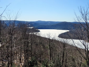
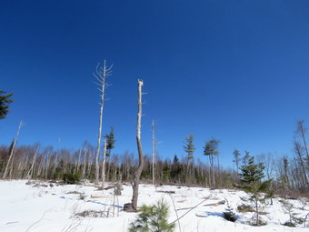
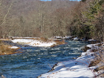
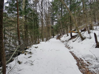
![]() On Sunday, March 21st I decided I wanted to hike closer to home after driving3 and half hours round trip to Schoharie County the day before. I asked Cindy if she would like to hike the trails in the Shavertown Parcel after church and she agreed. The Catskill Mountain Club created the trails in this area and added an additional trail in the fall with a lookout over the Tremperskill Valley. The weather forecast was for a bright and sunny day with high temperatures over 50 degrees. When we returned from church, Cindy ate some lunch and then we started to get ready. Sheila lay quietly on my floor but her eyes watched every movement I made. I put on my Mammut long-sleeved crew top but decided not to wear a baselayer since the temperature was unseasonably warm. I decided to wear my Columbia Titanium insulated pants without a baselayer underneath. I wore my Salomon B52 winter boots which are supportive, surprisingly roomy and discontinued. I had recently put a pair of Protalus insoles in these shoes and was anxious to see how they performed. The insoles in most hiking boots are a flimsy and flat piece of material. I grabbed my Leki external lock poles which I have been using lately since twist locks have proved unreliable. I also donned my Mammut hoody which was enough zippers to dump heat when needed. I put on a light Mountain Hardwear hat and wore a light pair of gloves. I also put on my OR Crocodile gaiters more out of habit than necessity. I wasn't sure if we would encounter any snow but I was pretty sure we would not need snowshoes. We both brought our Kahtoola microspikes which I hoped we would not have to use. I put our gear in the back of the car and Sheila in the backseat and left Livingston Manor at 12:50 PM. I headed north on the Quickway and got off at exit 94 for Roscoe. I drove through Roscoe and across the Rockland Flats on Route 206. I continued on Route 206 to the Pepacton Reservoir. Along the way we seemed to get behind people who wanted to travel well below the speed limit! At the Pepacton, I turned right on Route 30 to drive toward the bridge across the reservoir. After 12 miles, I turned left onto the bridge. At the other end of the bridge, I turned left and left again into the parking area. The lot was almost filled but I parked in an empty space. I hoped all of the people were not hiking the trail. I set my GPS and we headed north at 1:25 PM on CR 1 toward the trailhead which is only .1 miles from the parking area. There was no snow visible anywhere and the temperature was 54 degrees.
On Sunday, March 21st I decided I wanted to hike closer to home after driving3 and half hours round trip to Schoharie County the day before. I asked Cindy if she would like to hike the trails in the Shavertown Parcel after church and she agreed. The Catskill Mountain Club created the trails in this area and added an additional trail in the fall with a lookout over the Tremperskill Valley. The weather forecast was for a bright and sunny day with high temperatures over 50 degrees. When we returned from church, Cindy ate some lunch and then we started to get ready. Sheila lay quietly on my floor but her eyes watched every movement I made. I put on my Mammut long-sleeved crew top but decided not to wear a baselayer since the temperature was unseasonably warm. I decided to wear my Columbia Titanium insulated pants without a baselayer underneath. I wore my Salomon B52 winter boots which are supportive, surprisingly roomy and discontinued. I had recently put a pair of Protalus insoles in these shoes and was anxious to see how they performed. The insoles in most hiking boots are a flimsy and flat piece of material. I grabbed my Leki external lock poles which I have been using lately since twist locks have proved unreliable. I also donned my Mammut hoody which was enough zippers to dump heat when needed. I put on a light Mountain Hardwear hat and wore a light pair of gloves. I also put on my OR Crocodile gaiters more out of habit than necessity. I wasn't sure if we would encounter any snow but I was pretty sure we would not need snowshoes. We both brought our Kahtoola microspikes which I hoped we would not have to use. I put our gear in the back of the car and Sheila in the backseat and left Livingston Manor at 12:50 PM. I headed north on the Quickway and got off at exit 94 for Roscoe. I drove through Roscoe and across the Rockland Flats on Route 206. I continued on Route 206 to the Pepacton Reservoir. Along the way we seemed to get behind people who wanted to travel well below the speed limit! At the Pepacton, I turned right on Route 30 to drive toward the bridge across the reservoir. After 12 miles, I turned left onto the bridge. At the other end of the bridge, I turned left and left again into the parking area. The lot was almost filled but I parked in an empty space. I hoped all of the people were not hiking the trail. I set my GPS and we headed north at 1:25 PM on CR 1 toward the trailhead which is only .1 miles from the parking area. There was no snow visible anywhere and the temperature was 54 degrees.
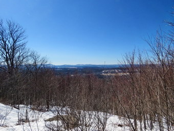
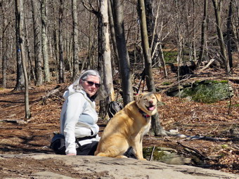 We turned right off the road and onto the trail. My first reaction was that it looked much more "used" than the last time I hiked it. The trail was mostly dirt with a few rocks and roots toward the upper end. There was some mud in spots and two or three small streams crossing the trail. There was no snow or ice to be seen anywhere. In .25 miles the trail gains 220 feet at a 16% grade which is a good way to get started. As we approached the end of the trail three young women came down the trail toward us. I pulled Sheila off to the side so that they could pass. The three hikers pulled their shirts over their mouths and said "Hi" as they passed. I took no offense but thought it a sad commentary on our COVID world! This section of trail ends on a road and there is a set of signs just across the road that direct hikers. We chose to cross the road and head toward the "Overlook". The trail we were on now was one that Cindy and I had helped create when the DEP closed the road that was being used to get to Snake Pond because of a logging project. This part of the trail was also worn in and was covered in pine needles and leaves. The stream that crossed the trail was as high as I have seen it but proved to be no obstacle. After .1 miles or .5 miles into the hike, we came to a sign that indicated that the new trail to the overlook turned to the left. We made the turn and started heading north gaining a little elevation as we continued along the trail. The trail was a little more worn in than when we had first hiked it in the fall and there were a few muddy spots along the way but still no snow or ice. At .7 miles the trail began to gain elevation more seriously. At times the trail followed old woods roads but only briefly. I expected to meet some people but we had the trail all to ourselves. Over the next half mile we continued to travel north gaining 350 feet. This is an average 14% grade but the last ascent is 26%. Just after the last ascent the trail turned west and descended slightly to a large rock shelf that serves as the overlook. The overlook gives a nice view of the Pepacton to the southwest and the Tremperskill Valley to the northwest. I dropped my pack and took out the camera. I took quite a few pictures of the scenery and some of Cindy and Sheila sitting on the rock. Sheila also posed for some solo pictures. I walked back out the trail to where there were some impressive rock formations and took a few shots. I did catch a glimpse of some snow and took a picture. We got a bar and a drink and the started back down the trail. Just as we started the steeper descent, I stopped to take some pictures of the ledges that made up the viewpoint. The return trip went quickly as we only had the few muddy spots to slow us down. We still had not met any people.
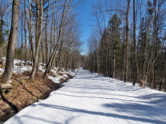
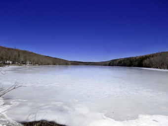
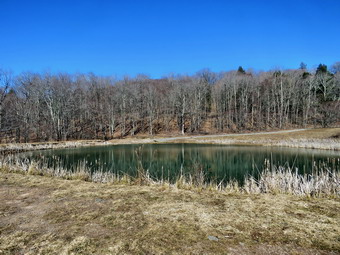 When we arrived back at the trail to the pond, we turned left and began to climb a little more. Cindy was a little tired of climbing but I slowed down and started to talk to her. The hike up to the pond was only .2 miles but we did gain another 155 feet. We emerged at the bench just below the pond but we continued up to the bench on the edge of the pond. I put my pack down and took out my camera. While I was doing this, I heard a splash and turned to see Sheila taking a swim in the icy water! I snapped some shots of the reservoir and the pond and then Cindy and I started walking clockwise around the pond. I stopped in several spots to take pictures. As we walked around the back of the pond, I noticed that the earthen bank that contained the water in the pond had been rebuilt. This meant that the trail around the back of the pond was in much better shape. I took some more pictures of the inlet and outlet of the pond which, strangely, are within a few feet of each other. We hiked up the road to the top of the hill above the pond and started to walk back to the car. The road was paved with large crushed stones and there were some patches of snow. Within a short distance the road opened up into a large field. Despite the lack of clouds and the overall bleak landscape, I decided to stop and take a few shots. A little further down the road, I stopped again to take some pictures of the meteorology equipment in the field. We continued our walk down the road entering the trees. We met a young couple hiking up the hill without any equipment at all. I realized that the hike to the pond and back is very short and I am always over prepared. At 2.75 miles we turned left on the trail which was well-marked with a large sign. The weather was still nice with plenty of sun and not even a slight breeze blowing. The trip down the trail was much quicker than the trip up. We did meet one man hiking up the trail even though it was late in the afternoon. When we reached the road we turned left and walked back to the car. It was 3:50 PM and we had hiked 3.1 miles in 2 hours and 20 minutes with 35 minutes of stopped time. The elevation gain was 980 feet. I wanted to determine the condition of Dibble Road that accesses the Pepacton Plateau Unit (DEP) so I headed north on CR 1 for 2.5 miles. I turned left on Dibble Road which was dirt and gravel and drove uphill to the end. I found a small parking area on the right where I pulled over. I got out of the car and tried to orient myself. I walked across the road and out to a field following a GPS track I had drawn and overlaid on my Avenza map. It showed I was in the right place so I returned to the car. I decided to drive counterclockwise around the reservoir which I had not done in some time. I though we would stop at the Pepacton Cemetery where the remains of those that had been buried in the valley now flooded by the reservoir had been reinterred. I though Cindy might enjoy the history but as we approached the cemetery she made it clear she had no interest so I drove home.
![]()
![]()
![]()
![]()
![]() On Saturday, March 20th, I was finally going to Schoharie County to work on a few of the Scary 19 high points. This list was created by Jason Pelton who lives in Schoharie County and chose 19 high points in state forests. When I looked at the weather forecast, it showed that Schoharie County would have highs of near 50 degrees so I wanted to get an earlier start so that we could take advantage of the frozen snow before it melted. I planned to try to get to the Lutheranville HP in Lutheranville State Forest, NW Fulton HP in Mallet Pond State Forest and Petersburg Mountain in Petersburg State Forest. These are the high points that are farthest away and I hope I could get to them all in one day. At 5:00 AM I responded to an ambulance call in Roscoe for the second night in a row returning at 7:30 Am. I questioned whether I should go as I was tired so I asked Cindy if she would like to come along. I knew that would limit me to only two of the hikes but I like the company. Cindy agreed and we started to get ready with the temperature still in the low 20's but with plenty of sun. Sheila was hanging around being a good dog but it was clear she was happy we were going outside. I put on my Mammut long-sleeved crew top with a long-sleeved baselayer since the temperature was cool. I decided to wear my Columbia Titanium insulated pants without a baselayer underneath. I wore my Salomon B52 winter boots which are supportive, surprisingly roomy and discontinued. I had recently put a pair of Protalus insoles in these shoes and was anxious to see how they performed. The insoles in most hiking boots are a flimsy and flat piece of material. I grabbed my Leki external lock poles which I have been using lately since twist locks have proved unreliable. I also donned my Mammut hoody which was enough zippers to dump heat when needed. I put on a fleecy orange hat and wore a light pair of gloves. I also put on my OR Crocodile gaiters which some almost to my knee to keep my lower legs warm. We decided to take snowshoes and spikes as I did not know the snow conditions in the area. I knew the increasing temperatures would make the snow soft and I knew that wearing them would preserve any track that was present. For snowshoes we decided to take our Tubbs Flex VRT which have the Boa binding. This system uses a thin steel cable system and a ratchet wheel which tightens it to give a custom fit and a secure binding. These snowshoes also have a televator to elevate the hiker's heel on ascents and take some strain off the calf muscles. This is a feature that you didn't know you needed until you try it and then it is hard to live without it! We both brought our Kahtoola microspikes which I hoped would be enough. We got our gear and Sheila in the car and headed north on State Route 17 at 8:45 AM. I got off at exit 94 for Roscoe and headed north in Route 206 toward Downsville. Just passed the traffic light in Downsville, I turned right on Telford Hollow Road and followed it over the mountain to Route 10. I turned right and headed north on Route 10 passing through Delhi, Bloomville, South Kortright, Hobart, Stamford and Jefferson. When I reached Summit, I turned left on Charlotte Valley Road and left on Spruce Lake Road at the top of the hill. This road was crushed stone alternating with large patches of snow. I had hoped to take this road through to Mud Lake Road to park near Mud Lake but after 1.2 miles the road was impassable. Spruce Lake met Moot Road near Fly Lake but Moot Road was also unplowed. There were several cars parked here and I judges it close enough that we could hike to the Lutheranville High Point from this intersection. I parked the car behind another and we began to get ready. We decided to wear our spikes as the road was packed snow and ice and the snow along the side of the road supported my weight. As we were getting ready an older man who had been cross country skiing came over to talk to us. He was from nearby Richmondville and said he often cross country skied and biked in the area. I set my GPS and we started north on the road at 10:40 AM.
On Saturday, March 20th, I was finally going to Schoharie County to work on a few of the Scary 19 high points. This list was created by Jason Pelton who lives in Schoharie County and chose 19 high points in state forests. When I looked at the weather forecast, it showed that Schoharie County would have highs of near 50 degrees so I wanted to get an earlier start so that we could take advantage of the frozen snow before it melted. I planned to try to get to the Lutheranville HP in Lutheranville State Forest, NW Fulton HP in Mallet Pond State Forest and Petersburg Mountain in Petersburg State Forest. These are the high points that are farthest away and I hope I could get to them all in one day. At 5:00 AM I responded to an ambulance call in Roscoe for the second night in a row returning at 7:30 Am. I questioned whether I should go as I was tired so I asked Cindy if she would like to come along. I knew that would limit me to only two of the hikes but I like the company. Cindy agreed and we started to get ready with the temperature still in the low 20's but with plenty of sun. Sheila was hanging around being a good dog but it was clear she was happy we were going outside. I put on my Mammut long-sleeved crew top with a long-sleeved baselayer since the temperature was cool. I decided to wear my Columbia Titanium insulated pants without a baselayer underneath. I wore my Salomon B52 winter boots which are supportive, surprisingly roomy and discontinued. I had recently put a pair of Protalus insoles in these shoes and was anxious to see how they performed. The insoles in most hiking boots are a flimsy and flat piece of material. I grabbed my Leki external lock poles which I have been using lately since twist locks have proved unreliable. I also donned my Mammut hoody which was enough zippers to dump heat when needed. I put on a fleecy orange hat and wore a light pair of gloves. I also put on my OR Crocodile gaiters which some almost to my knee to keep my lower legs warm. We decided to take snowshoes and spikes as I did not know the snow conditions in the area. I knew the increasing temperatures would make the snow soft and I knew that wearing them would preserve any track that was present. For snowshoes we decided to take our Tubbs Flex VRT which have the Boa binding. This system uses a thin steel cable system and a ratchet wheel which tightens it to give a custom fit and a secure binding. These snowshoes also have a televator to elevate the hiker's heel on ascents and take some strain off the calf muscles. This is a feature that you didn't know you needed until you try it and then it is hard to live without it! We both brought our Kahtoola microspikes which I hoped would be enough. We got our gear and Sheila in the car and headed north on State Route 17 at 8:45 AM. I got off at exit 94 for Roscoe and headed north in Route 206 toward Downsville. Just passed the traffic light in Downsville, I turned right on Telford Hollow Road and followed it over the mountain to Route 10. I turned right and headed north on Route 10 passing through Delhi, Bloomville, South Kortright, Hobart, Stamford and Jefferson. When I reached Summit, I turned left on Charlotte Valley Road and left on Spruce Lake Road at the top of the hill. This road was crushed stone alternating with large patches of snow. I had hoped to take this road through to Mud Lake Road to park near Mud Lake but after 1.2 miles the road was impassable. Spruce Lake met Moot Road near Fly Lake but Moot Road was also unplowed. There were several cars parked here and I judges it close enough that we could hike to the Lutheranville High Point from this intersection. I parked the car behind another and we began to get ready. We decided to wear our spikes as the road was packed snow and ice and the snow along the side of the road supported my weight. As we were getting ready an older man who had been cross country skiing came over to talk to us. He was from nearby Richmondville and said he often cross country skied and biked in the area. I set my GPS and we started north on the road at 10:40 AM.
 As we started out on the road, there was a breeze coming off the lake that was chilling but the bright sun compensated. Initially, there was a lot of ice on the road but that soon changed to hard packed snow with a layer of and inch or so of softer snow. The road had been groomed for snowmobiles and was well-traveled. We had decided to follow the roads to stay off private property and make the hike easier. For about a mile we continued to see POSTED signs on either side of the road. At the mile mark state forest signs appeared and we could see three skiers coming toward us. The skiers had a dog with them that was not on a leash. I put Sheila on her leash but the other dog was not interested in "making friends". We stopped to talk to the skiers who also had some knowledge of hiking. They were also local and often skied the roads in the area. We parted company and went our separate ways. In another .2 miles, we hit Mud Lake Road and turned left to start up a hill. After the first .3 miles, Moot Road had been a slight ascent but Mud Lake Road was steeper. Over the next .4 miles, we gained 190 feet with a 9% grade. I was looking for a snowmobile trail marked on the map. We found the snowmobile trail but it had not been used and did NT seem to offer an advantage. There was a clear cut on the right side of the road and we could see the high point at the top. We turned right and started to walk along the edge of the clear cut. The snow was supporting us for the most part but we broke through in a couple of places. We stopped a couple of times so that I could take pictures up the hill. The scene was pleasant but the lack of clouds made the sky look flat. The higher we got the more we could see the mountains and ridges around us. We entered the woods and kept pressing ahead through some thick brush toward the highest spot we could find. I stopped and check my GPS and found that the spot I thought was highest corresponded with the Latitude and longitude I had written down. We decided to head back the way we had come and followed our tracks back down to the road. Cindy broke through at one point and sank to above her knee.
 When we got to the road, we turned left and started back down the hill. Cindy's spikes kept collecting snow as the temperature rose so she decided to take them off. I was not having the same problem so I left mine on. The downhill went quickly and we soon made the turns onto Moot Road. The trip back was slightly downhill and we set a fast pace. We were back at the car at 12:50 Pm after hiking 3.9 miles in 2 hours and 20 minutes with 25 minutes of stopped time for a moving average of 2.1 mph. The elevation gain was 460 feet. I began to plan our route to Mallet Pond State Forest and our approach to NE Fulton Hill. It was then that Cindy announced she could not hike anymore uphill which meant that we could not hike anymore! This did not surprise me as it has happened before but I was disappointed and frustrated. Driving 3 and a half hours to hike 4 miles was not my idea of a good day. I decided I would drive over to Mallet Pond State Forest to check out the state of the roads. I drove out Spruce Lake Road and turned left on Charlotte Valley Road. In Summit, I turned left on Route 10 and then almost immediately right on Route 20, Sawyer Hollow Road. After a mile, I turned left on Rossmman Fly Road which looked promising and in good shape. After 1.7 miles, we came to the beginning of the state forest and the end of any road maintenance. Hiking from this access would require hiking .9 miles along Rossman Fly Road to Mallet Pond. From there it would be a mile to a mile and a half to NE Fulton Hill. I drove back out to Route 20 and turned left on Sawyer Hollow Road to check out the route from a snowmobile parking area on that road. As we drove along the road, it was clear why it was called Sawyer HOLLOW Road as there was a lot of downhill driving. I pulled over in the parking area and walked across the road to check out the trail. The trail was obvious and the distance to NE Fulton Hill was less than 2 miles but there seemed to be a lot of uphill hiking. I walked back to the car and drove home. On the way home it was all I could do to stay awake!
![]()
![]()
![]()
![]()
![]() On Friday, March 19th, I was planning to go to Schoharie County to work on a few of the Scary 19 high points. This list was created by Jason Pelton who lives in Schoharie County and chose 19 high points in state forests. When I looked at the weather forecast, it showed that Schoharie County would be 10 degrees colder than Livingston Mnaor with wind chills in the single digits until noon. I decided to do a hike closer to home and asked Cindy where she would like to go. Cindy chose the Beaverkill Campgrounds which was shorter than I had expected but I knew was scenic. I had been out the night before on an ambulance call from 3:45 AM to 7:00 AM so I slept in until 10:00 AM. When I got up, the temperature was 36 degrees. I took a quick trip to Liberty to collect a paycheck and then came back home and started to get ready. As usual, Sheila was excited and even more so since Cindy was going also. I put on my Mammut long-sleeved crew top with a long-sleeved baselayer since the temperature was cool. I decided to wear my Columbia Titanium insulated pants without a baselayer underneath. I wore my Salomon B52 winter boots which are supportive, surprisingly roomy and discontinued. I had recently put a pair of Protalus insoles in these shoes and was anxious to see how they performed. The insoles in most hiking boots are a flimsy and flat piece of material. I grabbed my Leki external lock poles which I have been using lately since twist locks have proved unreliable. I also donned my Mammut hoody which was enough zippers to dump heat when needed. I put on a fleecy orange hat and wore a light pair of gloves. I also put on my OR Crocodile gaiters which some almost to my knee to keep my lower legs warm. I decided to take snowshoes and spikes as I did not know the trail conditions. I knew the increasing temperatures would make the snow soft and I knew that wearing them would preserve any track that was present. I decided to take my TSL Symbioz snowshoes which have a lot of flex and are good for most terrain except for the steepest ascents on the 35s. They have a ratchet type binding and a televator for steeper climbs. The televator elevates the hiker's heel on ascents and take some strain off the calf muscles. This is a feature that you didn't know you needed until you try it and then it is hard to live without it! Cindy decided she would only take her spikes only. I put our gear in the back of the car and Sheila in the back seat and left the house at 12:45 PM. I drove out Old Route 17 toward Roscoe and turned right on Beaverkill Road. As we started the descent into the Beaverkill Valley, I turned left on Campsite Road and followed it down to the parking area near the Beaverkill Covered Bridge. As I parked, there were no other cars in the lot which was a sharp departure from the crowds this summer. The river was higher than I thought it might be.
On Friday, March 19th, I was planning to go to Schoharie County to work on a few of the Scary 19 high points. This list was created by Jason Pelton who lives in Schoharie County and chose 19 high points in state forests. When I looked at the weather forecast, it showed that Schoharie County would be 10 degrees colder than Livingston Mnaor with wind chills in the single digits until noon. I decided to do a hike closer to home and asked Cindy where she would like to go. Cindy chose the Beaverkill Campgrounds which was shorter than I had expected but I knew was scenic. I had been out the night before on an ambulance call from 3:45 AM to 7:00 AM so I slept in until 10:00 AM. When I got up, the temperature was 36 degrees. I took a quick trip to Liberty to collect a paycheck and then came back home and started to get ready. As usual, Sheila was excited and even more so since Cindy was going also. I put on my Mammut long-sleeved crew top with a long-sleeved baselayer since the temperature was cool. I decided to wear my Columbia Titanium insulated pants without a baselayer underneath. I wore my Salomon B52 winter boots which are supportive, surprisingly roomy and discontinued. I had recently put a pair of Protalus insoles in these shoes and was anxious to see how they performed. The insoles in most hiking boots are a flimsy and flat piece of material. I grabbed my Leki external lock poles which I have been using lately since twist locks have proved unreliable. I also donned my Mammut hoody which was enough zippers to dump heat when needed. I put on a fleecy orange hat and wore a light pair of gloves. I also put on my OR Crocodile gaiters which some almost to my knee to keep my lower legs warm. I decided to take snowshoes and spikes as I did not know the trail conditions. I knew the increasing temperatures would make the snow soft and I knew that wearing them would preserve any track that was present. I decided to take my TSL Symbioz snowshoes which have a lot of flex and are good for most terrain except for the steepest ascents on the 35s. They have a ratchet type binding and a televator for steeper climbs. The televator elevates the hiker's heel on ascents and take some strain off the calf muscles. This is a feature that you didn't know you needed until you try it and then it is hard to live without it! Cindy decided she would only take her spikes only. I put our gear in the back of the car and Sheila in the back seat and left the house at 12:45 PM. I drove out Old Route 17 toward Roscoe and turned right on Beaverkill Road. As we started the descent into the Beaverkill Valley, I turned left on Campsite Road and followed it down to the parking area near the Beaverkill Covered Bridge. As I parked, there were no other cars in the lot which was a sharp departure from the crowds this summer. The river was higher than I thought it might be.
 Cindy put on her spikes at the car which meant she would be walking on the pavement. I decided to carry my spikes and put them on at the beginning of the trail if needed. I set my GPS and we started our hike at 1:10 PM by crossing the bridge to the west side of the river. As we exited the bridge, I looked down the trail to the left and decided to forego the spokes. We turned left on a woods road that parallels the river and started down a short icy hill. I almost regretted not putting on the spikes as the ice extended across the trail. We both made it down without incident and walked passed a spring house. We continued on the deserted woods road which was almost clear of snow. We came to an area with a little path down to the river. I walked down to the edge of the river which was really roaring and took some pictures downstream and some upstream. Just after this area, the trail was highly eroded by water running across and under the trail. There was an area with several picnic tables and we noticed that there were piles of snow that had been piled up by plows. For some reason the DEC had plowed the old road that was no longer used! I decided to take pictures that showed the deserted campgrounds which was even more dramatic now that the snow was melting revealing what had been hidden. I took pictures of the picnic tables and, a little later, what was once a bathroom for some campsites that had long since disappeared. At the next bathroom, we stopped so that I could take some more pictures. There was a path over to the river so I walked over and took some pictures of the sun reflecting off the water both upstream and downstream. In several areas the DEC had placed large rocks along the shore and covered them with heavy wire to reduce erosion. At about .7 miles the woods road met the paved road that serves the campsites and we continued on the road through the campsites and along the river. Many of the campsites had a cement block fireplace with a grill but some were upgraded to poured concrete. Everything was very quiet except for the water in the river. This was not surprising as the campsites are closed. I took some pictures of the empty campsites and the plowed campsite road with banks of snow.
 We walked to the last campsite where the trail ends and walked down to the edge of the river. There was a strip of sand that made a small "beach" and I stopped to take some pictures. I worked my way out to a rock that jutted into the river and took some more shots up and down the stream. We turned around to start back and walked the other road through the campsites which parallels the one we walked out on to make a sort of loop. We stopped again so that I could take some pictures of a group of picnic tables randomly arranged and another group stacked against each other. I also took a few shots of the roads. We returned the way we had come crossing the river on the bridge. We stopped at the west end of the bridge and I took a few pictures upstream. We walked through the bridge and turned left as I wanted to walk upstream along the edge of the river which I had not done in some time. As we turned left in front of the cabin, we noticed a small stone memorial. It commemorated the founding of the National Campers and Hikers Association on July 4, 1949, at the Beaverkill Campgrounds. We walked over to the edge of the river and walked along the bank. I stopped and took some pictures upstream including a spot where the river splits. When I was done, we walked back toward the car. I walked over to the steps that lead down to the river. I was able to walk to a large rock that projects out into the stream. I took pictures of the bridge and bridge abutments. When I was done, I walked back to the car where Cindy was waiting. We talked about walking along the other side of the river but concluded it was time to go home. We were back at the car at 2:45 PM having hiked 2.4 miles in 1 hour and 40 minutes with 30 minutes of stopped time. The elevation gain was 200 feet but it was hardly noticeable. The car's thermometer read 39 degrees.
![]()
![]()
![]()
![]()
![]() On Wednesday, March 17th I wanted to get out for a longer hike but knew it had to be local as I had cross country practice at 3:15 PM. I had been avoiding Trout Pond for most of the winter as the parking situation is poor. Russell Brook Road is not maintained in the winter so the only parking is along the side of Morton Hill Road which only works when there are no snowplows working. When I got up at 8:00 AM it was already 30 degrees. Some snow had fallen overnight but not enough that the plows would be out. I waited for my grandson Bryce to arrive as I wanted to take him with me. When he showed up at 9:00 AM, he informed me that he had remote classes on and off for the rest of the day. I knew Sheila and I were on our own. I started to get ready at 9:45 AM and Sheila was especially excited as I began to dress so she watched every move I made. I put on my Mammut long-sleeved crew top with a long-sleeved baselayer since the temperature was cool. I decided to wear my Columbia Titanium insulated pants without a baselayer underneath. I wore my Salomon B52 winter boots which are supportive, surprisingly roomy and discontinued. I had recently put a pair of Protalus insoles in these shoes and was anxious to see how they performed. The insoles in most hiking boots are a flimsy and flat piece of material. I grabbed my Leki external lock poles which I have been using since the spring since twist locks have proved unreliable. I also donned my Mammut hoody which was enough zippers to dump heat when needed. I put on a fleecy orange hat and wore a light pair of gloves. I also put on my OR Crocodile gaiters which some almost to my knee to deal with the snow and to keep my lower legs warm. I decided to take snowshoes as I knew the increasing temperatures would make the snow soft and I knew that wearing them would preserve any track that was present. I decided to wear my TSL Symbioz snowshoes which have a lot of flex and are good for most terrain except for the steepest ascents on the 35s. They have a ratchet type binding and a televator for steeper climbs. The televator elevates the hiker's heel on ascents and take some strain off the calf muscles. This is a feature that you didn't know you needed until you try it and then it is hard to live without it! I put my gear in the back of the car and Sheila in the backseat and headed for Roscoe on the Quickway at 10:300 AM. I got off at exit 94, turned left and drove out the Rockland Flats on Route 206. Just after the Roscoe Nursing Home I turned left on Morton Hill Road and followed it for 3 miles to the intersection with Russell Brook Road. I turned around and parked on the shoulder of the road to avoid parking in the private lot. The temperature was 33 degrees with overcast skies. There was one car parked illegally on the private property near the intersection. I took a quick look at Russell Brook Road and found it a frozen mess if snow and ice and deep ruts where someone had thought they could drive. I did see some snowmobile tracks which I knew would make walking easier.
On Wednesday, March 17th I wanted to get out for a longer hike but knew it had to be local as I had cross country practice at 3:15 PM. I had been avoiding Trout Pond for most of the winter as the parking situation is poor. Russell Brook Road is not maintained in the winter so the only parking is along the side of Morton Hill Road which only works when there are no snowplows working. When I got up at 8:00 AM it was already 30 degrees. Some snow had fallen overnight but not enough that the plows would be out. I waited for my grandson Bryce to arrive as I wanted to take him with me. When he showed up at 9:00 AM, he informed me that he had remote classes on and off for the rest of the day. I knew Sheila and I were on our own. I started to get ready at 9:45 AM and Sheila was especially excited as I began to dress so she watched every move I made. I put on my Mammut long-sleeved crew top with a long-sleeved baselayer since the temperature was cool. I decided to wear my Columbia Titanium insulated pants without a baselayer underneath. I wore my Salomon B52 winter boots which are supportive, surprisingly roomy and discontinued. I had recently put a pair of Protalus insoles in these shoes and was anxious to see how they performed. The insoles in most hiking boots are a flimsy and flat piece of material. I grabbed my Leki external lock poles which I have been using since the spring since twist locks have proved unreliable. I also donned my Mammut hoody which was enough zippers to dump heat when needed. I put on a fleecy orange hat and wore a light pair of gloves. I also put on my OR Crocodile gaiters which some almost to my knee to deal with the snow and to keep my lower legs warm. I decided to take snowshoes as I knew the increasing temperatures would make the snow soft and I knew that wearing them would preserve any track that was present. I decided to wear my TSL Symbioz snowshoes which have a lot of flex and are good for most terrain except for the steepest ascents on the 35s. They have a ratchet type binding and a televator for steeper climbs. The televator elevates the hiker's heel on ascents and take some strain off the calf muscles. This is a feature that you didn't know you needed until you try it and then it is hard to live without it! I put my gear in the back of the car and Sheila in the backseat and headed for Roscoe on the Quickway at 10:300 AM. I got off at exit 94, turned left and drove out the Rockland Flats on Route 206. Just after the Roscoe Nursing Home I turned left on Morton Hill Road and followed it for 3 miles to the intersection with Russell Brook Road. I turned around and parked on the shoulder of the road to avoid parking in the private lot. The temperature was 33 degrees with overcast skies. There was one car parked illegally on the private property near the intersection. I took a quick look at Russell Brook Road and found it a frozen mess if snow and ice and deep ruts where someone had thought they could drive. I did see some snowmobile tracks which I knew would make walking easier.
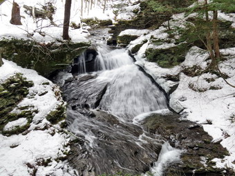
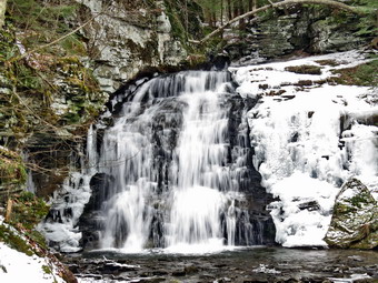 I put on my snowshoes and set my Garmin GPS unit and we started down Russell Brook Road as I planned to make the upper falls our first stop. Once we were passed the deep ruts the snow was for a long time and frozen solid. I noticed fresh bare boot tracks and wondered how far the two people from the other car would get. The frozen snow allowed me to make good time hiking downhill. Sheila always makes good time. Before we reached the campsite on the left of the trail, Sheila alerted and I could see two hikers coming toward us with their Samoyed. The dog was on a leash but seemed to be very interested in meeting Sheila. I pulled over to the side if the trail but the man with his dog on a leash decided to let him check out Shiela. Both Sheila and I indicated this was not a good idea! Both people looked at me and said "You are prepared. We were not." I gave them credit for turning around when they found their boots alone weren't sufficient. We headed in our opposite directions. We continued to walk quickly downhill to the path down to the viewpoint above the falls. We turned down the path to the upper falls which had some snow on it. I soon realized that the thin layer of snow covered a thick layer of ice. Fortunately, my snowshoes had enough traction to handle the situation. I called Sheila away from the edge of the gorge and put down my pack and got out the camera. There was more water going over the falls than I thought there might be as I took several shots with differing settings. Once I finished the photography, I packed up, and we walked back up to the road. The lot, of course, was empty but there were snowmobile tracks across it which headed down toward Russell Brook. We walked down the woods road to cross Russell Brook. We crossed the bridge and found that the Japanese knotweed was completely dead. It was so dead it looked like it could never come back but it does every year. We turned right on the informal path to the falls and walked the path until we came to the path down the bank. The path had almost no snow until we came to the descent to the streambed where there was a combination of hard packed snow and ice. At the point where I was about to try to get down to the streambed, I noticed it was solid ice. I decided to take pictures from where I was standing which offered a view almost as good as from lower down. The falls were flowing with a good volume as high as I had seen it in some time. I took some pictures of the falls and then some of the stream. I took a few more pictures of the falls and a few of Sheila with the falls in the background. When I was done I stowed the camera and we carefully walked back up the stream bank and out to the main trail.
 We turn right to walk to the trail register and found that this was where the couple we had met turned around. We stayed to the right at the trail junction just after the register and continued straight ahead to walk up to Trout Pond. The trail was packed by snowmobiles and easily supported my weight and would have without snowshoes. There were a few places where the snow was thin and where small streams crossed the trail or ran down it. Not too far up the trail we came to the spot where Ranger Steven Ellis and I had worked on a blowdown that had blocked the trail. When we had finished what we could do, the trail was open but Ranger Ellis deiced that clearing the rest of that blowdown would require the operations crew. The blowdown was no longer there and had been very neatly removed. We continued our walk up the trail and I began to feel warm. When we arrived at the pond, we turned left and walked out to the "beach" at the outlet end of the pond. The level of the pond was high enough to allow water to pass over the outlet even thigh the pond was still covered with ice. The skies were completely overcast as I got out my camera. As Sheila walked out on the ice, I took shots of the pond including some of Sheila on the ice. I took some pictures of the whole scene and then zoomed in on different parts. After getting a drink and a snack, I packed up and we headed back to the main trail. We turned left and continued on the main trail on the east side of Trout Pond walking toward the inlet end and the lean-tos. The trail was snow covered and well-packs in most places with a few open spots. I did stop at one spots to take some more pictures of the pond and surrounding hills. No one was camping at the large campsite on the right side of the trail before the lean-tos or at the lean-tos themselves. As we crossed the bridge at the inlet end of the pond, I noticed that the inlet stream was high. I decided not to stop to take pictures of the pond from the bridge as I was on a tight schedule. We continued on the trail by turning right and starting up a hill which is the shoulder of Cherry Ridge. I had been worried that I would have to break trail here but the snowmobile tracks continued all the way up and over the shoulder of Cherry Ridge. We easily walked up the hill and I noticed it was easier walking on the smooth packed trail than over the rocks and roots that are usually there. A large cherry trunk had broken off high up and fallen with the butt on the trail. It was firmly wedged up above and I knew it would not be safe to cut it. As we continued to hike, we ran into a few blowdowns from the recent winds. A few of the larger ones had been cut with a chainsaw and removed from the trail. Other blowdowns were smaller and covered in snow so that they would have to wait until all the snow was gone. Soon we were at the highest point on Cherry Ridge and starting down the other side.
 I anticipated that the trail would have some open areas with water and I was right. There were places that had some standing water and some flowing like a stream. Of course, in these areas walking with snowshoes was more difficult. We passed by several spots where I had cleared blowdowns previously. We continued on the trail to the point where we were ascending to the area where there is a forest of small birch trees. Sooner than I thought we were at the woods road and snowmobile trail that runs by Mud Pond. We turned left and started the short walk uphill. This part of the trail still had a good covering of snow that made the hiking easier. At the top of the hill, we began the long descent back to the trail junction where we had started. The descent lasts for .7 miles and drops 385 feet to a bridge that crosses the outlet stream from Trout Pond. The further we descended, the less snow was on the trail. I wanted to keep the snowshoes on so I ended up walking on the side of the trail where there was still some snow or on a layer of ice. The campsite at the bottom of the hill on the left side of the trail was also empty but by this time there was more snow on the trail. I knew I was behind schedule so we continued on the trail crossing the bridge over the stream and walking back out to the trail register. We turned right and headed back toward the lower parking area on the main trail. We walked up the short path to the lower parking area and continued up the road to the car. The hike up the hill to the car proved to be less of a challenge than when there is no snow. As we came to Morton Hill Road, I could see a forest ranger's truck at the top of the hill. The truck was running with the ranger inside so I stopped to say "Hello". The occupant was Ranger Joe Brink who has been in Delaware County foe 13 years. He told me that he and Ranger Ellis had cleared the blowdown. We raked about trail conditions and equipment. We also discussed the recent rescue at Kaaterskill Falls and the recovery of a body from the top of the Becker Hollow trail on Hunter Mountain. I excused my self and walked to the car. We arrived back at the car at 2:05 PM after hiking 5.5 miles in 3 hours and 10 minutes with a 1115 foot total ascent. The temperature on the car thermometer was 36 degrees.
![]()
![]()
![]()
![]() On Tuesday, March 6th I knew I had to get out for a short hike before I got ready for afternoon cross country practice. I decided that I would go across the street and hike on Round Top since I would not have to spend time traveling. When I awoke at 6:30 AM, the temperature was only 25 degrees with a slight breeze. I had several things to do around the house so I did not start getting ready until 11:30 AM. Sheila seemed very happy to be going out. I put on my Mammut long-sleeved crew top with a long-sleeved baselayer since the temperature was cool. I decided to wear my Columbia Titanium insulated pants without a baselayer underneath. I wore my Salomon B52 winter boots which are supportive, surprisingly roomy and discontinued. I had recently put a pair of Protalus insoles in these shoes and was anxious to see how they performed. The insoles in most hiking boots are a flimsy and flat piece of material. I did not expect much snow although the possibility of mud was on my mind. I grabbed my Leki external lock poles which I have been using since the spring since twist locks have proved unreliable. I also donned my Mammut hoody which was enough zippers to dump heat when needed. I put on a fleecy orange hat and wore a light pair of gloves. I also put on my OR Crocodile gaiters which some almost to my knee to deal with the snow and to keep my lower legs warm. I decided to forego the snowshoes and wear my Kahtoola microspikes as it had been cold during the day and at night and I was rue the trail would be frozen. We stepped out of the house at noon. I grabbed Sheila's leash from the car and put it on her to safely cross the street. We walked up the driveway and crossed the street. We mounted the snow bank left by the plow and headed across the field by the church. The snow was very sparse but what was there was firmly frozen. As we started up the hill, I realized that there wasn't much snow left in the areas exposed to the sun. It did not look like anyone had been on the trail in some time. We began the ascent of the steepest hill behind the church. The hill is short but gets the circulation pumping and is the steepest and longest climb on the "trail." I let Sheila off her leash so that I could use my poles to get up the hill. Sheila immediately began to bound up the hill as I followed. There was still some snow visible on the surrounding hills. When we got to the top of the hill, we stopped to look around at the hills around town. There was a haze or fog hanging in the valley and a light mist surround us. We started on the trail by turning left at the trailhead. The track was pretty well preserved but was starting to deteriorate from melting. I also noticed some boot prints and postholes to the side of the track.
On Tuesday, March 6th I knew I had to get out for a short hike before I got ready for afternoon cross country practice. I decided that I would go across the street and hike on Round Top since I would not have to spend time traveling. When I awoke at 6:30 AM, the temperature was only 25 degrees with a slight breeze. I had several things to do around the house so I did not start getting ready until 11:30 AM. Sheila seemed very happy to be going out. I put on my Mammut long-sleeved crew top with a long-sleeved baselayer since the temperature was cool. I decided to wear my Columbia Titanium insulated pants without a baselayer underneath. I wore my Salomon B52 winter boots which are supportive, surprisingly roomy and discontinued. I had recently put a pair of Protalus insoles in these shoes and was anxious to see how they performed. The insoles in most hiking boots are a flimsy and flat piece of material. I did not expect much snow although the possibility of mud was on my mind. I grabbed my Leki external lock poles which I have been using since the spring since twist locks have proved unreliable. I also donned my Mammut hoody which was enough zippers to dump heat when needed. I put on a fleecy orange hat and wore a light pair of gloves. I also put on my OR Crocodile gaiters which some almost to my knee to deal with the snow and to keep my lower legs warm. I decided to forego the snowshoes and wear my Kahtoola microspikes as it had been cold during the day and at night and I was rue the trail would be frozen. We stepped out of the house at noon. I grabbed Sheila's leash from the car and put it on her to safely cross the street. We walked up the driveway and crossed the street. We mounted the snow bank left by the plow and headed across the field by the church. The snow was very sparse but what was there was firmly frozen. As we started up the hill, I realized that there wasn't much snow left in the areas exposed to the sun. It did not look like anyone had been on the trail in some time. We began the ascent of the steepest hill behind the church. The hill is short but gets the circulation pumping and is the steepest and longest climb on the "trail." I let Sheila off her leash so that I could use my poles to get up the hill. Sheila immediately began to bound up the hill as I followed. There was still some snow visible on the surrounding hills. When we got to the top of the hill, we stopped to look around at the hills around town. There was a haze or fog hanging in the valley and a light mist surround us. We started on the trail by turning left at the trailhead. The track was pretty well preserved but was starting to deteriorate from melting. I also noticed some boot prints and postholes to the side of the track.
At the first trail junction, I followed Sheila as she continued straight ahead up the hill toward the viewpoint. The climb up the hill was not particularly tiring but was a little tricky as there was almost no snow or ice and I was wearing spikes! At the viewpoint there wasn't much to see so Sheila and I headed to the right to follow the main yellow trail as it turned right and headed up the gentle hill through the hardwood forest. The snowshoe track had deteriorated some from the melting and there were plenty of postholes from those unprepared to hike on soft snow. The snow was hard and even when I stepped off the track the snow still supported my weight. Sheila was making her own way by staying on the trail some times and then running off trail and sticking her head under the snow at every opportunity. She was also picking up sticks and dragging them along and off the trail. We continued to follow the yellow trail toward the first junction with the blue trail. At the first trail junction with the blue trail, we turned right and followed the yellow trail along the base of Round Top. This section was a mess of craters which made the hiking dangerous. At the next junction, we turned left and started up to the summit of Round Top on the blue trail. We bypassed the white crossover trail and continued up and over the summit. When we started down the other side, I decided we would skip the white crossover trail and the new switchback on the blue trail and just continue down the hill. I was able to get a pretty good grip with my spikes but some areas were very icy as the snow had melted and refrozen several times. The steepest part of the hill was tricky but the poles helped me to keep my balance and get down without falling. At the bottom of the hill we turned left on the yellow trail, walked along the base of Round Top. At the trail junction with the blue trail, we turned right to walk down to the woods road. It was a snap to walk downhill and out the woods road. It was obvious Sheila felt the same way as she was running and bounding ahead of me and then running back up the trail toward me. We walked the woods road out to the first trail junction. We immediately turned around and walked back up the woods road to the junction with the blue trail. I had to call Sheila back as she was following game trails and inspecting the "caves". We turned left and walked along the yellow trail following the base of the Round Top summit. At the next junction we turned right and started up the steeper side of the hill on the blue trail. The spikes were very helpful as the trail was icy. This time we followed the switchback in the blue trail which was not broken out but still supported my weight. It was also obvious that not many people had taken this trail as the track was hard to find. We followed the switchback as it turned back toward the main trail. We turned right on the main trail and right again almost immediately on the white-blazed crossover trail. This too was less used than the main trails and I had to look closely to find the track. On the other side of the hill we came to the main trail and turned right to hike downhill to the junction with the yellow trail. We turned right on the yellow trail and followed it along the base of Round Top once again. At the junction with the blue trail we turned to the left to stay on the yellow trail to the lookout. At the lookout we followed the yellow trail as it turned left and descended over bare ground to the first trail junction. We walked straight out to the trailhead and turned right to walk to the bottom of the hill. We headed across the church parking lot and the field next to it. We crossed the road to our driveway and were home by 1:15 PM after hiking a little over 2 miles in 1 hour and 15 minutes.
![]()
![]()
![]()
![]()
![]()
![]() On Saturday, March 13th, I had planned to hike some of the Scary 19 in Schoharie County including Bates HP and High Knob. On Thursday I took advantage of an opportunity to get the Johnson and Johnson COVID-19 vaccine and was feeling a little off on Friday. The weather report for Saturday included temperatures below freezing with winds making the "feel like" temperature in the low 20's. I wasn't sure I wanted to take Sheila out to take Shiela out in temperatures that cold so I went to bed unsure of what I would do. When I got up it wasn't that cold in Livingston Manor and the wind was blowing at a moderate speed. I finally decided that I wanted at least go to scout out some of the Scary 19. I asked Cindy if she wanted to go and she agreed. We finally started to get ready at 10:00 AM. I put on my long-sleeved Patagonia wool zip top with a light long-sleeved baselayer underneath. I decided to wear my Columbia Titanium insulated pants to keep the chill away with a pair of light tights underneath. I wore my Salomon B-52 insulated boots as they keep my feet warm and dry and work well with snowshoes. I had recently put a pair of Protalus insoles in these shoes and was anxious to see how they performed. The insoles in most hiking boots are a flimsy and flat piece of material. I also applied a new waterproofing and leather preservative which has proved very effective. I went with my new Follow Hollow alpaca sock which are thick and warm and come to my midcalf. I grabbed a pair of Leki external lock poles I have been using all season. I also put on my OR Crocodile gaiters. Finally, I donned my Mammut hoody which blocks the wind and keeps me warm but has enough zippers to dump heat when needed. I put on a fleecy orange hat for warmth. For snowshoes Cindy decided to take her Tubbs Flex VRT which have the Boa binding. This system uses a thin steel cable system and a ratchet wheel which tightens it to give a custom fit and a secure binding. These snowshoes also have a televator to elevate the hiker's heel on ascents and take some strain off the calf muscles. This is a feature that you didn't know you needed until you try it and then it is hard to live without it! I decided to wear my TSL Symbioz snowshoes which have a lot of flex and are good for most terrain except for the steepest ascents on the 35s. They have a ratchet type binding and a televator for steeper climbs. I had no idea what the conditions might be like since most of the Scary 19 hikes are bushwhacks and there might not be a trench. I also always pack my microspikes since they are sometimes more appropriate. I put our gear in the back and Sheila in the back seat and we left Livingston Manor at 10:30 AM. I head north on State Route 17 to Roscoe to take Route 206 toward Downsville. I thought I had covered everything until I asked Cindy if she had brought her spikes. She said "No" and I wondered if we would be okay on some of the routes we might encounter. I decided we would continue knowing that being unprepared would limit our choices.
On Saturday, March 13th, I had planned to hike some of the Scary 19 in Schoharie County including Bates HP and High Knob. On Thursday I took advantage of an opportunity to get the Johnson and Johnson COVID-19 vaccine and was feeling a little off on Friday. The weather report for Saturday included temperatures below freezing with winds making the "feel like" temperature in the low 20's. I wasn't sure I wanted to take Sheila out to take Shiela out in temperatures that cold so I went to bed unsure of what I would do. When I got up it wasn't that cold in Livingston Manor and the wind was blowing at a moderate speed. I finally decided that I wanted at least go to scout out some of the Scary 19. I asked Cindy if she wanted to go and she agreed. We finally started to get ready at 10:00 AM. I put on my long-sleeved Patagonia wool zip top with a light long-sleeved baselayer underneath. I decided to wear my Columbia Titanium insulated pants to keep the chill away with a pair of light tights underneath. I wore my Salomon B-52 insulated boots as they keep my feet warm and dry and work well with snowshoes. I had recently put a pair of Protalus insoles in these shoes and was anxious to see how they performed. The insoles in most hiking boots are a flimsy and flat piece of material. I also applied a new waterproofing and leather preservative which has proved very effective. I went with my new Follow Hollow alpaca sock which are thick and warm and come to my midcalf. I grabbed a pair of Leki external lock poles I have been using all season. I also put on my OR Crocodile gaiters. Finally, I donned my Mammut hoody which blocks the wind and keeps me warm but has enough zippers to dump heat when needed. I put on a fleecy orange hat for warmth. For snowshoes Cindy decided to take her Tubbs Flex VRT which have the Boa binding. This system uses a thin steel cable system and a ratchet wheel which tightens it to give a custom fit and a secure binding. These snowshoes also have a televator to elevate the hiker's heel on ascents and take some strain off the calf muscles. This is a feature that you didn't know you needed until you try it and then it is hard to live without it! I decided to wear my TSL Symbioz snowshoes which have a lot of flex and are good for most terrain except for the steepest ascents on the 35s. They have a ratchet type binding and a televator for steeper climbs. I had no idea what the conditions might be like since most of the Scary 19 hikes are bushwhacks and there might not be a trench. I also always pack my microspikes since they are sometimes more appropriate. I put our gear in the back and Sheila in the back seat and we left Livingston Manor at 10:30 AM. I head north on State Route 17 to Roscoe to take Route 206 toward Downsville. I thought I had covered everything until I asked Cindy if she had brought her spikes. She said "No" and I wondered if we would be okay on some of the routes we might encounter. I decided we would continue knowing that being unprepared would limit our choices.
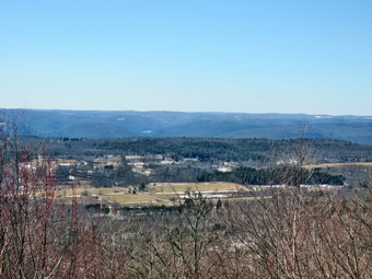 At the Pepacton Reservoir, I turned right on Route 30 and headed toward Margaretville. I continued north on Route 30 through Roxbury and Grand Gorge. This ride is beautiful and usually enjoyable but I was in a hurry to get where I was going. A little outside of Grand Gorge I turned east on Route 990V and continued through the Conesvilles. The road became Potter Mountain Road and I continued another 2.6 miles after Durham Road split to the right. I turned left on Goodfellow Road and came to Bates Forest Road on the right. The "road" was marked private and followed a power line right-of-way. I turned right and drove in a short way but ended up backing out as I could not find a place to park. I got back on Potter Mountain Road heading west and turned right on East Conesville Road. I drove 1.2 miles uphill to the point where Bates Forest Road came in from the right. This end was also marked "Private" and was covered in snow so I decided to drive on to Shale Pit Road to see what the access to High Knob looked like. I drove another .75 miles and turned right on Shale Pit Road. The first part of this road looked promising but it soon narrowed and snow covered. I drove to a point where I could see High Knob on the right across a field but there was no place to park. I back out until I could turn around and drove back to East Conesville Road. I turned left and drove back to Bates Forest Road. I decided to park on the shoulder of the road and walk to Bates HP. Cindy did not want to do this so I continued back to Paotter Mountain Road thinking about being 0 for 2 so far. I turned right on Potter Mountain Road and drove back toward Route 30 thinking about going anywhere to get in a hike. Cindy suggested Mine Kill but I knew she would need spikes. I also knew Vroman's Nose would probably require spikes also. I decided to go to Hubbard Hill and Leonard Hill just north of Broome Center. I had hiked here before in the winter so I did not need then for the Scary 19 but I knew it would probably be a good snowshoe hike. I drove north on Route 30 to Breakabeen where I turned right on Route 36. After a short drive uphill, I turned right on Route 17 to drive to Broome Center. I turned left on Route 61 and immediately right on Leonard Hill Road. The road was clear as I drove 1.2 miles to a small parking area on the left of the road. I was surprised to see that the sign for Leonard Hill State Forest was missing but I knew we were in the right spot. When we got out of the car, the temperature was 35 degrees but a stiff breeze made me feel cold. I set my GPS and grabbed my snowshoes out of the car. Cindy took her snowshoes and immediately started to put them on. I walked up the road to the start of the trail and put my snowshoes on where the snow began.
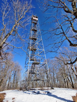 We started out on the trail which is sited along a woods road for the entire hike. There was over a foot of snow on the trail which was packed by snowmobiles. I could also see some old snowshoe tracks. As we walked we were able to stay on top of the snow without sinking in. In a few places the very top layer of snow had become soft but it did not stick to our shoes. When I stepped off the trail, I sank deeply into the snow. Sheila was just glad to be out again as she ran ahead of us and explored off the trail a little. Over the first .7 miles, the trail headed southwest and uphill as we gained 275 feet. The grade was only 8% and we made good time. We gained a little more elevation was we approached Hubbard Hill and followed the road as it turned to the west at .9 miles. I pointed out to Cindy that we were passing Hubbard Hill on our right. I decided to bypass Hubbard on the way out and hit it on the return trip. The last time I was in the trail, which was 8 years ago, I had not been sure of the exact location of the tower or what trail might lead to it. I remembered the description that said the road led to the fire tower and the story that the fire tower was moved from Gilbert Lake State Park. It was relocated to Hubbard Hill but the Conservation Department named it after a nearby hill, Leonard Hill. At least this was how the story went! I now knew that the hills and the fire tower were named correctly! We walked uphill a little more as the trail skirted Hubbard Hill. We hit the a high point and then began a .3 mile descent to the col between Hubbard Hill and Leonard Hill. We were now walking northwest again toward Leonard Hill. After only about .35 miles I looked to my left and saw the fire tower. We continued walking on the road which led around the mountain and right to the base of the tower. I continued a short distance beyond the turn to the tower to a lookout to the north and west. I took some pictures while waiting for Cindy to catch up. When Cindy arrived, I told her to come see the views but she decided to sit on a log. I put away my camera and walked over to the base of the fire tower. The clearing was small so it was difficult to get pictures of the tower. I took some shots and then walked to the other side where I could get further way from the tower. From that direction I could get more of the tower in the picture but the sun was in the field of view.
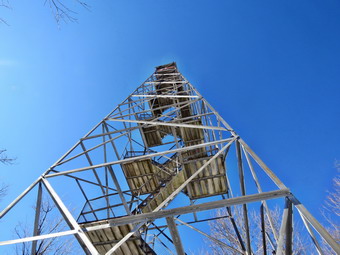 I inspected the tower and it looked in good shape. I could see that the floor of the cab was missing but that the rest of the tower appeared to be in good shape. The bottom two sets of steps had been removed but could easily be replaced. I am not sure why this tower doesn't get the love that other towers get but I think it could easily be restored. Sheila and I got a drink and we all started back at 2:05 PM. The snow was a little softer on the way back but the packed trail still supported us. As we approached Hubbard Hill at 2.2 miles, I left the trail to the right and started the ascent of Hubbard Hill which is a few feet higher than Leonard Hill. Cindy decided to continue on the trail. Sheila and I walked up the hill. The first ascent was a little steep but then there was a gradual climb to the highest point through open woods. At some point I realized Sheila was no longer with me and I assumed she had gone to find Cindy. I called her but she did not come which did not make me happy. At the highest point I found a snowshoe track from someone else who was doing the Scary 19. I followed it downhill to the main trail where I met Cindy and Sheila. We set a faster pace as we crossed some level ground and then a long downhill back to the trailhead. When we got to the road, I removed my snowshoes and carried them back to the car. Cindy decide to walk back to the car with her snowshoes on. We were back at the car at 3:05 PM after hiking 3.4 miles in 2 hours. We had stopped for 22 minutes but our moving average was 2.1 mph. The elevation gain was 588 feet. On the way back, I turned left off Route 17 onto Campbell Road to see if I could find a place to park for Keyserkill State Forest. After .6 miles an access road appeared on the right but there did not seem to be a place to park. I drove back out to Route 17. At the end of that road we turned right which was a wrong turn! We ended up in Middleburgh which added some distance to the drive home. I had considered stopping at Mine Kill but decided I just wanted to stay in the car!
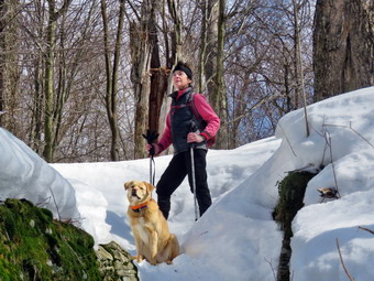
![]() On Tuesday, March 9th I had promised to hike somewhere with Lisa. We discussed several places to hike but did not know if parking would be available. We agreed to go to Big Pond and hike up Touch-Me-Not Mountain to the site of an old farm on the Little Pond Trail. Lisa would not be available until 10:30 AM so I was not sure how far we would be Abel to hike as I had to be back for cross country practice in the afternoon. I started to get ready at 10:00 AM when the temperature was already 46 degrees. As I was starting to get dressed, Lisa texted me saying she was leaving Livingston Manor at 10:10 AM so I tried to speed up getting ready. Sheila seemed happy that I was getting dressed and kept watching me. I put on my Mammut long-sleeved crew top with a long-sleeved baselayer since the temperature was cool. I decided to wear my Columbia Titanium insulated pants without a baselayer underneath. I wore my Salomon B52 winter boots which are supportive, surprisingly roomy and discontinued. I had recently put a pair of Protalus insoles in these shoes and was anxious to see how they performed. The insoles in most hiking boots are a flimsy and flat piece of material. I grabbed my Leki external lock poles which I have been using since the spring since twist locks have proved unreliable. I also donned my Mammut hoody which was enough zippers to dump heat when needed. I put on a fleecy orange hat and wore a light pair of gloves. I also put on my OR Crocodile gaiters which some almost to my knee to deal with the snow and to keep my lower legs warm. I decided to take snowshoes as I knew the increasing temperatures would make the snow soft and I knew that wearing them would preserve any track that was present or help us to create one. I decided on wearing my Tubb's Flex VRT which have the Boa binding. This system uses a thin steel cable system and a ratchet wheel which tightens it to give a custom fit and a secure binding. These snowshoes also have a televator to elevate the hiker's heel on ascents and take some strain off the calf muscles. This is a feature that you didn't know you needed until you try it and then it is hard to live without it! I put my gear in the back and Sheila in the back seat and left Livingston Manor at 10:25 AM. I drove north on Old Route 17 toward Roscoe and turned right on the Beaverkill Road. I followed Beaverkill Road through Lew Beach and turned left on Barkaboom Road just before the hamlet of Turnwood. I drove up the road to Big Pond and parked in the lot at the side of the road where Lisa was already waiting.
On Tuesday, March 9th I had promised to hike somewhere with Lisa. We discussed several places to hike but did not know if parking would be available. We agreed to go to Big Pond and hike up Touch-Me-Not Mountain to the site of an old farm on the Little Pond Trail. Lisa would not be available until 10:30 AM so I was not sure how far we would be Abel to hike as I had to be back for cross country practice in the afternoon. I started to get ready at 10:00 AM when the temperature was already 46 degrees. As I was starting to get dressed, Lisa texted me saying she was leaving Livingston Manor at 10:10 AM so I tried to speed up getting ready. Sheila seemed happy that I was getting dressed and kept watching me. I put on my Mammut long-sleeved crew top with a long-sleeved baselayer since the temperature was cool. I decided to wear my Columbia Titanium insulated pants without a baselayer underneath. I wore my Salomon B52 winter boots which are supportive, surprisingly roomy and discontinued. I had recently put a pair of Protalus insoles in these shoes and was anxious to see how they performed. The insoles in most hiking boots are a flimsy and flat piece of material. I grabbed my Leki external lock poles which I have been using since the spring since twist locks have proved unreliable. I also donned my Mammut hoody which was enough zippers to dump heat when needed. I put on a fleecy orange hat and wore a light pair of gloves. I also put on my OR Crocodile gaiters which some almost to my knee to deal with the snow and to keep my lower legs warm. I decided to take snowshoes as I knew the increasing temperatures would make the snow soft and I knew that wearing them would preserve any track that was present or help us to create one. I decided on wearing my Tubb's Flex VRT which have the Boa binding. This system uses a thin steel cable system and a ratchet wheel which tightens it to give a custom fit and a secure binding. These snowshoes also have a televator to elevate the hiker's heel on ascents and take some strain off the calf muscles. This is a feature that you didn't know you needed until you try it and then it is hard to live without it! I put my gear in the back and Sheila in the back seat and left Livingston Manor at 10:25 AM. I drove north on Old Route 17 toward Roscoe and turned right on the Beaverkill Road. I followed Beaverkill Road through Lew Beach and turned left on Barkaboom Road just before the hamlet of Turnwood. I drove up the road to Big Pond and parked in the lot at the side of the road where Lisa was already waiting.
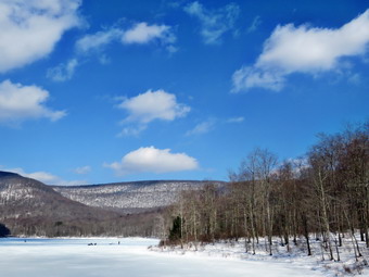 Sheila became very exited when she saw Lisa and I let her out of the car to say hello. Lisa and I put on our snowshoes and I set my GPS. The temperature was 42 degrees as we headed across the road to the beginning of the trail up Touch-Me-Not Mountain on the Touch-Me-Not Trail which is part of the Finger Lakes Trail. The first part of the trail is an old woods road, and it is pretty easy to follow. There was at least a foot of snow packed on the trail and more to either side. Although the temperature was above freezing, the snow was still firm. We stopped at the register so that Lisa could sign in and then started back up the trail. I maintain the section of trail from Alder Lake to Beech Hill Road for the Finger Lakes Trail Conference and was interested to see how the trail had fared over the winter. The first mile of the trail gains about 775 feet with an average grade of 15%. Some places are almost flat which means there are a few steeper places. I began to notice that the blazing of the trail could be better. Volunteers used to be able to put up trail markers, but the DEC decided that a forester must now do this. Most blazes were too far apart. Some were very old and faded with others grown into the trees. A few were on the side of the tree meaning they were not visible from either direction on the trail. We followed the snowshoe trench which followed the trail. We found one new blowdown that had fallen diagonally across the trail and would be tricky to clear. The trench was in pretty good shape although there were some postholes. In a few places, the trail traveled along the side of the hill, and this made for some tricky footing. We took it easy on the steeper parts of the trail toward the top of the climb and started down toward the junction with the Campground Trail. We passed under another large blowdown with barely enough room. This blowdown is no big problem in other seasons but the buildup of snow made it more difficult. At the junction we turned right to stay on the Touch-Me-Not Trail. I told Lisa we did not have enough time to hike to the site of the old farm. Lisa wanted to hike to a particular old and majestic maple tree so we started down the trail. We stopped at one spot where the trail descends between some rocks. I took a few pictures of Lisa and Sheila and some of the trail. We continued our walk and arrived at the tree. I took some pictures of Lisa and Sheila at the tree and the we started back. The hike back to the trail junction went quickly. When we started own the mountain toward the car, we picked up the pace. The snow was getting softer and we were both sinking in much more than on the ascent. We passed the register and walked down to the road. My snowshoe became tangled in a small root that was hidden under the snow. I took a spill but quickly righted myself. Sheila and I walked across the road to the shores of Big Pond. I took pictures of the pond and the mountains behind. There were people ice fishing on Big Pond and there was open water near the out let. We were back at the car at 1:15 PM after hiking 2.6 miles in 2 hours and 25 minutes. The temperature was 46 degrees but the sun made it feel much warmer.
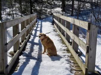
![]()
![]()
![]()
![]()
![]() On Sunday, March 7th I wanted to get out for a longer hike after a series of shorter hikes. I asked Cindy if she wanted to hike but she declined as see thought she might be coming down with a cold. I decided to go to Frick Pond to do the Frick Pond to Hodge Pond loop on the Quick Lake and Flynn Trails which is a little over 6 miles. After church, I started to get ready with the temperature hovering at 32 degrees and blue, cloudless skies. Sheila sat watching my every move to make sure she would not be left behind. I put on my Mammut long-sleeved crew top with a long-sleeved baselayer since the temperature was cool. I decided to wear my Columbia Titanium insulated pants without a baselayer underneath. I wore my Salomon B52 winter boots which are supportive, surprisingly roomy and discontinued. I had recently put a pair of Protalus insoles in these shoes and was anxious to see how they performed. The insoles in most hiking boots are a flimsy and flat piece of material. I grabbed my Leki external lock poles which I have been using since the spring since twist locks have proved unreliable. I also donned my Mammut hoody which was enough zippers to dump heat when needed. I put on a fleecy orange hat and wore a light pair of gloves. I also put on my OR Crocodile gaiters which some almost to my knee to deal with the snow and to keep my lower legs warm. I decided to wear my TSL Symbioz snowshoes which have a lot of flex and are good for most terrain except for the steepest ascents on the 35s. They have a ratchet type binding and a televator for steeper climbs. The televator elevates the hiker's heel on ascents and take some strain off the calf muscles. This is a feature that you didn't know you needed until you try it and then it is hard to live without it! I knew I would wear the snowshoes for the entire trip. Even though I expected much of the trail to be packed by hikers and snowmobiles, I thought that the Flynn Trail from Junkyard Junction to Hodge Pond might be lightly traveled. I also wanted to make sure I improved the track and left no postholes if the snow softened. I put my gear in the back and Sheila in the backseat and drove out the Debruce Road about 6 miles. I turned left onto Mongaup Pond Road and continued to where the road split. I turned left onto Beech Mountain Road, and drove to the parking areas at the Frick Pond. The smaller lot was full of cars with one group getting ready to head out. I parked in the larger lot as there were no cars there. The car thermometer read 29 degrees as I set my GPS but a slight breeze made it feel colder. At 12:50 PM we headed out the Quick Lake Trail toward the trail register.
On Sunday, March 7th I wanted to get out for a longer hike after a series of shorter hikes. I asked Cindy if she wanted to hike but she declined as see thought she might be coming down with a cold. I decided to go to Frick Pond to do the Frick Pond to Hodge Pond loop on the Quick Lake and Flynn Trails which is a little over 6 miles. After church, I started to get ready with the temperature hovering at 32 degrees and blue, cloudless skies. Sheila sat watching my every move to make sure she would not be left behind. I put on my Mammut long-sleeved crew top with a long-sleeved baselayer since the temperature was cool. I decided to wear my Columbia Titanium insulated pants without a baselayer underneath. I wore my Salomon B52 winter boots which are supportive, surprisingly roomy and discontinued. I had recently put a pair of Protalus insoles in these shoes and was anxious to see how they performed. The insoles in most hiking boots are a flimsy and flat piece of material. I grabbed my Leki external lock poles which I have been using since the spring since twist locks have proved unreliable. I also donned my Mammut hoody which was enough zippers to dump heat when needed. I put on a fleecy orange hat and wore a light pair of gloves. I also put on my OR Crocodile gaiters which some almost to my knee to deal with the snow and to keep my lower legs warm. I decided to wear my TSL Symbioz snowshoes which have a lot of flex and are good for most terrain except for the steepest ascents on the 35s. They have a ratchet type binding and a televator for steeper climbs. The televator elevates the hiker's heel on ascents and take some strain off the calf muscles. This is a feature that you didn't know you needed until you try it and then it is hard to live without it! I knew I would wear the snowshoes for the entire trip. Even though I expected much of the trail to be packed by hikers and snowmobiles, I thought that the Flynn Trail from Junkyard Junction to Hodge Pond might be lightly traveled. I also wanted to make sure I improved the track and left no postholes if the snow softened. I put my gear in the back and Sheila in the backseat and drove out the Debruce Road about 6 miles. I turned left onto Mongaup Pond Road and continued to where the road split. I turned left onto Beech Mountain Road, and drove to the parking areas at the Frick Pond. The smaller lot was full of cars with one group getting ready to head out. I parked in the larger lot as there were no cars there. The car thermometer read 29 degrees as I set my GPS but a slight breeze made it feel colder. At 12:50 PM we headed out the Quick Lake Trail toward the trail register.
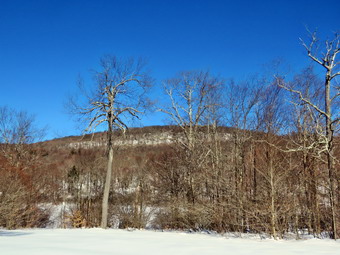 As we approached the register, two hikers were coming back from the direction of the pond and were heading up the woods road to the smaller lot. They were wearing only boots. We turned left at the register and headed out the woods road toward Frick Pond. The trail was covered in hard packed snow and showed a few bare boot prints but no snowshoes. A few of the small streams that cross the trail were running with some water but were easily crossed. The snow was crystalline and was not sticking to my snowshoes. At Gravestone Junction, we turned left to stay on the Quick Lake Trail and head down to Frick Pond. We stopped at the bridge across the outlet to Frick Pond and I took some shots of the pond and Flynn's Point. I always stop to take pictures even when the scene is not remarkable. The outlet stream below the bridge was still covered in snow and snow drifts. We didn't stay long and were soon walking along the west side of Frick Pond where the snow was still packed. At the junction with the Big Rock Trail, we stayed to the left as we wanted to keep hiking the Quick Lake Trail. The track now was very narrow and there did not seem to be evidence of any new travel except for some ski tracks. The tracks looked new as if they had been made only minutes before we got there. It was not easy navigating the first part of the trail as there were some postholes and several places where there was some open water. We entered the evergreen tunnel where the track became a little more consolidated. When we came to the small stream across the trail, Sheila easily jumped across the water but I had my doubts. The water level was low enough to allow me to step on a small stone and make it across the stream. Just after this crossing I had to make my way up a steep bank of snow but the snowshoes worked well and I had no problem. We continued to push toward Iron Wheel Junction and made good time even though the track was in poor shape in many places. When we came to Iron Wheel Junction, I had to decide if I wanted to take the shorter route on the Logger's Loop or continue with the original plan to got to Hodge Pond. The Quick Lake Trail to the left was packed by snowmobiles and I was feeling fresh so I decided to head to Hodge Pond by turning left at 1:40 PM after hiking 1.5 miles.
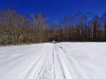 The sun was out which always makes me feel better but the temperature did not seem much warmer. This was probably good since the snow remained frozen and did not clump in my snowshoes. Sheila was having a great time staying on the trail with me most of the time with a few off-trail excursions. We could hear some snowmobiles in the distance but none of them ever passed by us as we hiked. The next mile of trail is all uphill but the grade only averages around 8%. At times this can seem like a long slog but on this day it seemed to go quickly. IN some ways the walk was easier since the trail was absolutely smooth without the eroded gulleys that lie beneath. The constant climb did begin to tire my legs and although the scenery was beautiful it began to get repetitive. We hit the flatter ground and started downhill toward Junkyard Junction where we arrived at 2:30 PM after hiking 3.1 miles. We turned right to start out on the Flynn Trail and almost immediately I noticed that the trail was packed by snowmobiles. I knew this would make the hiking easier but I was disappointed that the snowmobiles had ignored the signs at both ends of this trail that say SNOWMOBILES PROHIBITED". There are always some hikers that trespass and do not follow rules. I guess the snowmobile community also have those that do whatever they want to do. Just after making the turn, we both heard some conversation. I looked in the woods on the left side of the trail and saw two men sitting and relaxing. I struck up a conversation and found that they were the skiers whose tracks I had seen. They had gone as far as Hodge Pond were now returning the way they had come. Sheila and I worked our way along the trail until wee arrived at the gate which separates the state land from the Open Spaces Institute land around Hodge Pond. We continued on the Flynn Trail by turning right and following the trail downhill to an area near the shore of Hodge Pond. The downhill stretch was very enjoyable and I was glad that the last 1.7 miles of the hike is all downhill on the Flynn Trail. We turned right to stay on the Flynn Trail and walked through the forest and then out to the field. I stopped to take a few pictures of the sun ion the snow and of Beech Mountain which is not visible fro the outlet end of the pond. The track was almost completely drifted in where the snow had been blown by the wind coming off the pond. I packed up and we walked to the point where the Flynn Trail enters a clearing at the outlet end of Hodge Pond. We walked over to the shore of the pond and found the sky was a flat blue without any clouds. I took some pictures of the pond and the surroundings but a stiff breeze off the pond had me hurrying to pack up and leave. We headed back across the field to the point where the Flynn Trail enters the forest and began the walk up the hill on the Flynn Trail. This was the last climb before the long downhill back to the car.
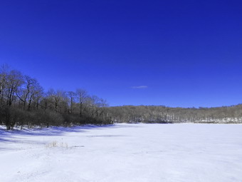 The walk up this hill often seems tedious but on this day it went quickly as there was a packed snowmobile track. We were soon at the top of the hill. We walked along the flat trail under the trees passing through the other gate. The snowmobiles had simply ignored the gate and the signs and had driven around the gate! We arrived at the junction with the Big Rock trail at 3:25 PM after hiking 4.8 miles. We continued straight ahead on the Flynn Trail. I had hoped to have a relaxing trip down the hill but this was not the case. The entire Flynn Trail back to the parking area was a mess. The people who had sued snowshoes did not seem to know about forming one well-packed trench! At one point, I counted five different sets a parallel snowshoes tracks. This was compounded by set of postholes made by barebooters who are either ignorant or inconsiderate of others. Of course, all of these had frozen making an easy and smooth walk back impossible. I tried to pick the best path but the walk back was anything but pleasant and seemed to take a long tome. I much prefer walking up the Flynn Trail but like to vary the route from time to time. We Finlay reached the spot where there is an interesting clearing to the left of the trail but there were no tracks going in that direction so I decided to stay on the main trail. We continued on the trail and soon were passing through the tunnel Cindy and I had cut in a large spruce tree that had fallen across the trail. At the gate at the bottom of the hill, we turned left on the trail to avoid the private property around the cabin. Most people had done this but there were some boot prints that continued through the gate proving people can't read or don't care. When we got back to the parking area, there were two cars in the small lot and only mine in the larger. It was 4:10 PM when we got back to the car after hiking 6.4 miles in 3 hours and 20 minutes with an elevation gain of 905 feet. We had maintained an overall speed of 2.0 mph with a moving average of 2.1 mph which I thought was good for the conditions. The temperature was 28 degrees and we were both ready to go home.
![]()
![]()
![]()
![]() On Friday, March 5th I had planned to get out and do a longer hike with Balsam Lake Mountain in mind. Once again the ambulance called and I responded leaving the house at 1830 and returning until 2330! When I got up late, I looked at the forecast for wind chills below 0 and decided it would be too cold to take Sheila on a long hike. Despite this Sheila was begging to get out so I decided to go across the street to Round Top and do a few loops. I started to get ready at 11:15 AM when the temperature was 25 degrees and the wind was blowing with some heavy gusts. Sheila seemed very happy that we would be going out even though we had been out several times during the week. I put on a Patagonia wool sweater which is very warm so I decided not to wear a baselayer. I decided to wear my Columbia Titanium insulated pants without a baselayer underneath. I wore my Salomon B52 winter boots which are supportive, surprisingly roomy and discontinued. I had recently put a pair of Protalus insoles in these shoes and was anxious to see how they performed. The insoles in most hiking boots are a flimsy and flat piece of material. I did not expect much snow although the possibility of mud was on my mind. I grabbed my Leki external lock poles which I have been using since the spring since twist locks have proved unreliable. I also donned my Mammut hoody which was enough zippers to dump heat when needed. I put on a fleecy orange hat and wore a light pair of gloves. I also put on my OR Crocodile gaiters which some almost to my knee to deal with the snow and to keep my lower legs warm. I decided to forego snowshoes as I was pretty sure the snowshoe track I had set earlier in the week would be packed and frozen. I did decide to wear my Kahtoola Microspikes for some traction on the trails. Sheila kept me in sight as I got ready to go making sure she would not be forgotten. We stepped out of the house at 11:40 AM. I grabbed Sheila's leash from the car and put it on her to safely cross the street. We walked up the driveway and crossed the street. We mounted the snow bank left by the plow with some difficulty and headed across the field by the church. As we started across the field, I could see the track I had set and stayed in it. The packed snow in the track supported me without a problem. As we started up the hill behind the church, I realized that there was still a lot of snow! The hill is short but gets the circulation pumping and is the steepest and longest climb on the "trail." Sheila off her leash so that I could use my poles to get up the hill. Sheila immediately began to bound up the hill as we followed. The cemetery was covered in snow and some snow was still visible on the surrounding hills. When we got to the top of the hill, we stopped to look around at the hills around town. I walked off the track and found the crust would support me while standing but I left significant holes when walking. We started on the trail by turning left at the trailhead. There were no new prints on the trail.
On Friday, March 5th I had planned to get out and do a longer hike with Balsam Lake Mountain in mind. Once again the ambulance called and I responded leaving the house at 1830 and returning until 2330! When I got up late, I looked at the forecast for wind chills below 0 and decided it would be too cold to take Sheila on a long hike. Despite this Sheila was begging to get out so I decided to go across the street to Round Top and do a few loops. I started to get ready at 11:15 AM when the temperature was 25 degrees and the wind was blowing with some heavy gusts. Sheila seemed very happy that we would be going out even though we had been out several times during the week. I put on a Patagonia wool sweater which is very warm so I decided not to wear a baselayer. I decided to wear my Columbia Titanium insulated pants without a baselayer underneath. I wore my Salomon B52 winter boots which are supportive, surprisingly roomy and discontinued. I had recently put a pair of Protalus insoles in these shoes and was anxious to see how they performed. The insoles in most hiking boots are a flimsy and flat piece of material. I did not expect much snow although the possibility of mud was on my mind. I grabbed my Leki external lock poles which I have been using since the spring since twist locks have proved unreliable. I also donned my Mammut hoody which was enough zippers to dump heat when needed. I put on a fleecy orange hat and wore a light pair of gloves. I also put on my OR Crocodile gaiters which some almost to my knee to deal with the snow and to keep my lower legs warm. I decided to forego snowshoes as I was pretty sure the snowshoe track I had set earlier in the week would be packed and frozen. I did decide to wear my Kahtoola Microspikes for some traction on the trails. Sheila kept me in sight as I got ready to go making sure she would not be forgotten. We stepped out of the house at 11:40 AM. I grabbed Sheila's leash from the car and put it on her to safely cross the street. We walked up the driveway and crossed the street. We mounted the snow bank left by the plow with some difficulty and headed across the field by the church. As we started across the field, I could see the track I had set and stayed in it. The packed snow in the track supported me without a problem. As we started up the hill behind the church, I realized that there was still a lot of snow! The hill is short but gets the circulation pumping and is the steepest and longest climb on the "trail." Sheila off her leash so that I could use my poles to get up the hill. Sheila immediately began to bound up the hill as we followed. The cemetery was covered in snow and some snow was still visible on the surrounding hills. When we got to the top of the hill, we stopped to look around at the hills around town. I walked off the track and found the crust would support me while standing but I left significant holes when walking. We started on the trail by turning left at the trailhead. There were no new prints on the trail.
At the first trail junction, I followed Sheila as she turned right on the woods road which is the shallower approach to the trail system. I followed the snowshoe track that I had set the day before which made the walking much easier. We continued to follow the yellow trail toward the first junction. At the junction, we turned left and followed the track to the next trail junction. There was some snow that had blown into the track but I could easily follow the trench. I did notice that I was not cold at all and, in fact, was sweating a little. It helped that the trees protected us from the wind which was howling through the treetops. At the second junction with the blue trail, we turned right and started up the steep blue trail that leads over the summit of Round Top. On this ascent the trench was almost completely drifted in and I left a few prints in the loose snow. Just before the steepest section we turned right on the switchback trail marked with blue paint blazes. I could see the track on this trail but I had only walked over it one time with snowshoes so it was not well packed. Still, the track supported me without me sinking into the snow. We continued to follow these blazes as they made a sharp left turn and headed back to the main blue trail. We turned right on the blue trail and continued up the blue trail. Within a few feet, we turned right on the white crossover trail which I also had only walked one time with snowshoes. We followed the trail to the end where it intersected the blue trail on the other side of Round Top. We turned right and headed down to the junction with the blue trail. At the junction, we turned right and walked slog the base of Round Top again to the second junction with the blue trail. This time we turned left and followed the yellow trail downhill to the lookout. The packed track continued to support me without a problem. At the viewpoint, we turned left and walked downhill to the first trail junction. We immediately turned around and headed back up the steep section of trail to the viewpoint. We followed the yellow trail as it turned right at the lookout and headed uphill toward the junction with the blue trail. At the junction, we turned right and walked along the based of Round Top to the next junction with the blue trail. At the junction, we turned left and started up the trail to the summit. We passed over the summit and started down the longest and steepest section on the trail. I decided to bypass the white crossover trail and the switchback on the blue trail. When we got to the bottom of the blue trail, we turned left on the yellow trail and walked over the well-packed trench to the next junction. We turned right and walked down the yellow trail to the woods road and out to the first trail junction. We turned left and walked out to the trailhead. The sun was out but the wind had picked up. We made quick work of the downhill walking behind the church and across the field to our driveway. We were back at the house at 12:40 PM having walked a little over 2 miles in an hour.
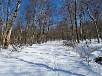
![]()
![]()
![]()
![]()
![]() On Wednesday, March 3rd, I was ready to get out for a hike before going to cross country practice in the in afternoon. I like coaching but the afternoon practices limit my hiking options as I don't want to be late. Several of the places I thought about Like Trout Pond and Cabot Mountain from Beech Hill Road have questionable parking situations so I decided to once again head for the Frick Pond area. The forecast was for temperatures in the 40's but when I got up in the morning it was 30 degrees. I started to get ready at 9:45 AM when the temperature was up to 33 degrees. I put on my Mammut long-sleeved crew top with a long-sleeved baselayer since the temperature was cool. I decided to wear my Columbia Titanium insulated pants without a baselayer underneath. I wore my Salomon B52 winter boots which are supportive, surprisingly roomy and discontinued. I had recently put a pair of Protalus insoles in these shoes and was anxious to see how they performed. The insoles in most hiking boots are a flimsy and flat piece of material. I grabbed my Leki external lock poles which I have been using since the spring since twist locks have proved unreliable. I also donned my Mammut hoody which was enough zippers to dump heat when needed. I put on a fleecy orange hat and wore a light pair of gloves. I also put on my OR Crocodile gaiters which some almost to my knee to deal with the snow and to keep my lower legs warm. I decided to wear my TSL Symbioz snowshoes which have a lot of flex and are good for most terrain except for the steepest ascents on the 35s. They have a ratchet type binding and a televator for steeper climbs. The televator elevates the hiker's heel on ascents and take some strain off the calf muscles. This is a feature that you didn't know you needed until you try it and then it is hard to live without it! As I was getting ready Sheila stayed near me so that I would not "forget" her but was being a very well-behaved dog. I put my gear in the car and Sheila in the back seat. She was happy to be going anywhere and crouched in the back seat with her head on the console. We left Livingston Manor at 10:15 AM under blue skies with the temperature reading 35 degrees. I drove out the DeBruce Road about 6 miles to Mongaup Road and turned left. I continued up the road to the point where it splits and stayed left on Beech Mountain Road. It was a short drive to the parking areas on the left. I pulled into the smaller parking area where there was one other car parked. There was a car and a pickup truck in the larger lot with a group of hikers getting ready to start. My plan was to hike up the Flynn Trail toward Hodge Pond and make a decision where to go when we reached the intersection with the Big Rock Trail. I put on my snowshoes and set my GPS to get ready to hike with the temperature at 33 degrees. I was concerned that as the temperatures rose the snow would start to melt and clump on the snowshoes.
On Wednesday, March 3rd, I was ready to get out for a hike before going to cross country practice in the in afternoon. I like coaching but the afternoon practices limit my hiking options as I don't want to be late. Several of the places I thought about Like Trout Pond and Cabot Mountain from Beech Hill Road have questionable parking situations so I decided to once again head for the Frick Pond area. The forecast was for temperatures in the 40's but when I got up in the morning it was 30 degrees. I started to get ready at 9:45 AM when the temperature was up to 33 degrees. I put on my Mammut long-sleeved crew top with a long-sleeved baselayer since the temperature was cool. I decided to wear my Columbia Titanium insulated pants without a baselayer underneath. I wore my Salomon B52 winter boots which are supportive, surprisingly roomy and discontinued. I had recently put a pair of Protalus insoles in these shoes and was anxious to see how they performed. The insoles in most hiking boots are a flimsy and flat piece of material. I grabbed my Leki external lock poles which I have been using since the spring since twist locks have proved unreliable. I also donned my Mammut hoody which was enough zippers to dump heat when needed. I put on a fleecy orange hat and wore a light pair of gloves. I also put on my OR Crocodile gaiters which some almost to my knee to deal with the snow and to keep my lower legs warm. I decided to wear my TSL Symbioz snowshoes which have a lot of flex and are good for most terrain except for the steepest ascents on the 35s. They have a ratchet type binding and a televator for steeper climbs. The televator elevates the hiker's heel on ascents and take some strain off the calf muscles. This is a feature that you didn't know you needed until you try it and then it is hard to live without it! As I was getting ready Sheila stayed near me so that I would not "forget" her but was being a very well-behaved dog. I put my gear in the car and Sheila in the back seat. She was happy to be going anywhere and crouched in the back seat with her head on the console. We left Livingston Manor at 10:15 AM under blue skies with the temperature reading 35 degrees. I drove out the DeBruce Road about 6 miles to Mongaup Road and turned left. I continued up the road to the point where it splits and stayed left on Beech Mountain Road. It was a short drive to the parking areas on the left. I pulled into the smaller parking area where there was one other car parked. There was a car and a pickup truck in the larger lot with a group of hikers getting ready to start. My plan was to hike up the Flynn Trail toward Hodge Pond and make a decision where to go when we reached the intersection with the Big Rock Trail. I put on my snowshoes and set my GPS to get ready to hike with the temperature at 33 degrees. I was concerned that as the temperatures rose the snow would start to melt and clump on the snowshoes.
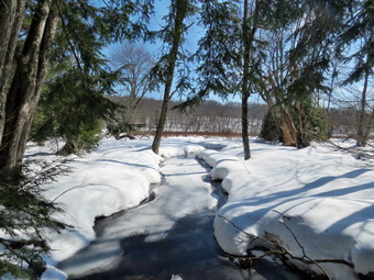 We crossed the road at 10:35 AM, went up and over the snow bank and got on the Flynn Trail to walk around the private property around the cabin at the end of the road. I immediately noticed that there was a well defined snowshoe track with almost no new snow in the track. I could see that another hiker had been on the track and was not wearing snowshoes. I hoped that the hiker had made the right decision and would not chew up the track with postholes as the snow got deeper at higher elevations and softer as the temperature rose. I also immediately noticed a number of small and larger branches on the trail. I picked up the branches and removed them from the trail and thought how easy this would have been for the other hiker. Many people seem to hike the trails without any thought about making them better. I know this is true because I was once one of those people. At the end of the trail through the woods we turned right on a woods road which is sited along what was once the Beech Mountain Road. This road was the access for the Beech Mountain Boy Scout Camp. We began the ascent on the trail following the snowshoe track. There was one well set track but someone had ignored the track and had walked beside the main track. In some places there were as many as three sets of snowshoe prints. I am always amazed when I see people wearing snowshoes but ignoring the common sense practice of making one well-packed trench! Using snowshoes is pretty easy but having the common sense to create a track apparently is not. I have always thought that snowshoeing did not require any particular skills but I am beginning to think there should be courses! The day was crisp and clear with blue skies and some sun. The trail gains a little over 600 feet in 1.75 miles to the highest point at the junction with the Big Rock Trail. We passed through the arch Cindy and I had cut through an enormous hemlock that had fallen across the trail. We walked up the trail with a few stops for me to take some pictures and catch my breath. As we gained elevation the snow became softer and the hiker ahead of us kept switching from one track to another to avoid sinking in. The hiker was not successful and began to leave deeper and deeper holes in the snow. It was hard for me to do too much repair as the snow was still frozen. The further we went the more snow had drifted into the trench and the more annoying the holes became. I thought it a shame that someone's poor planning ruined the experience for other people. When we came to the clearing on the right, we passed by as I wanted to stay on the main trail. I was having some problems with the snow sticking to my snowshoes but I had expected this an periodically lifted the shoes and banged them with a poles to clear them. A short distance after the clearing at one mile the snow increased to two feet off the track. The last half mile or so to the junction with the Big Rock Trail was not as enjoyable as I broke the trail through the drifted snow and tried to smooth out the mess the barebooter had made. Several times I called Sheila back to me and then had her run back up the trail. She did a very effective job of helping to break out the trail. As we neared the highest point on the trail at the junction with the Big Rock Trail, I looked at the time and decided to head down the Big Rock Trail and leave Hodge Pond for another day. We reached the junction after hiking 1.7 miles uphill and now would have over a mile descent.
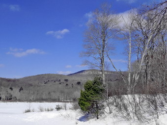 We turned left and started down the Big Rock Trail which was well-packed by snowmobiles. I could see that the barebooter had also turned down the Big Rock Trail and I was happy that they would not ruin any more trails. As we walked down the trail, we could hear snowmobiles and I thought the noise was coming from the Flynn Trail. I waited on the trail and could see the machines coming from the direction of Hodge Pond. This trail is off-limits to snowmobiles but it was obvious these riders didn't care! They turned down the Big Rock Trail and slowed to pass us. I took it as another example of people who feel they are entitled to do whatever they want. We set a faster pace as we descended the trail passing through the various twists and turns that often make it seem like the bottom of the hill is close. The trail was well packed by the snowmobiles and was even easier to hike than when there was no snow as it was very smooth. About halfway down the trail, two more machines came up the trail from Times Square. These machines had trail maintenance equipment on them and I assumed they were members of the snowmobile club doing some trail clearing. The trip downhill went quickly and we were soon at Times Square. We continued straight across to stay on the Big Rock Trail. I immediately noticed that some of the tracks were from snowshoes and some from bare boots including fresh tracks from the hikers we had been following. Snowshoes were helpful for me but I could have walked without as so many had chosen to do. We came to the bridges over the streams that feed Frick Pond where there was some water flowing under the ice that had formed on top. We stopped so that I could take a few pictures before continuing on. When we came to the large spruce log that had fallen across the trail, I was glad that I had been able to remove it because it made hiking the trail so much easier than having to climb over it. We walked along the trail under the spruce trees before crossing the wooden walkways that were laden with snow. At the end of the Big Rock Trail, we turned left on the Quick Lake Trail and walked to the bridge over the outlet stream. I took some pictures of the beaver dam, the pond and Flynn's Point on Beech Mountain as I often do. The snow had drifted to almost cover the dam and had filled in the outlet stream below the bridge. After taking the pictures, I packed up and we continued up the hill to Gravestone Junction. We continued on the trail and back out to the car. The Quick Lake Trail back to the parking area was almost completely frozen over with a combination of packed snow and ice. The small streams that normally cross the trail were also almost completely frozen. At the register we continued straight ahead on the woods road. We arrived at the car at 1:00 PM after hiking 3.9 miles in 2 hours and 20 minutes. The elevation gain was 680 feet. The temperature at the car was 36 degrees. The pickup truck in the large lot was still the only other vehicle.
![]()
![]()
![]()
![]() On Monday, March 1st I knew I had to get out for a hike despite the forecast that called for rain and then high winds. We had not been out hiking for a week due to the terrible weather and my substituting as school nurse for several days. I decided that I would go across the street and hike on Round Top since I would not have to spend time traveling and could return home if the rain began to fall. When I awoke at 6:30 AM, the temperature was already 34 degrees with some light rain falling. I delayed my hike until the rain all but stopped and the temperature had risen to 38 degrees. I started getting ready at 9:30 AM and Sheila seemed very happy to be going out. I put on my Mammut long-sleeved crew top with a long-sleeved baselayer since the temperature was cool. I decided to wear my Columbia Titanium insulated pants without a baselayer underneath. I wore my Salomon B52 winter boots which are supportive, surprisingly roomy and discontinued. I had recently put a pair of Protalus insoles in these shoes and was anxious to see how they performed. The insoles in most hiking boots are a flimsy and flat piece of material. I did not expect much snow although the possibility of mud was on my mind. I grabbed my Leki external lock poles which I have been using since the spring since twist locks have proved unreliable. I also donned my Mammut hoody which was enough zippers to dump heat when needed. I put on a fleecy orange hat and wore a light pair of gloves. I also put on my OR Crocodile gaiters which some almost to my knee to deal with the snow and to keep my lower legs warm. I decided to wear my TSL Symbioz snowshoes which have a lot of flex and are good for most terrain except for the steepest ascents on the 35s. They have a ratchet type binding and a televator for steeper climbs. We stepped out of the house at 10:15 AM. I grabbed Sheila's leash from the car and put it on her to safely cross the street. We walked up the driveway and crossed the street. We mounted the snow bank left by the plow and headed across the field by the church. The snow was very heavy and wet but did not stick to my snowshoes. There was a breeze blowing that I hoped would disappear once we got on the trails. As we started up the hill, I realized that there was still a lot of snow and I was glad I could still see the track I had set. It did not look like anyone had been on the trail in some time. We began the ascent of the steepest hill behind the church. The hill is short but gets the circulation pumping and is the steepest and longest climb on the "trail." I let Sheila off her leash so that I could use my poles to get up the hill. Sheila immediately began to bound up the hill as I followed. The cemetery was still covered in snow and all there was till snow on the surrounding hills. When we got to the top of the hill, we stopped to look around at the hills around town. There was a haze or fog hanging in the valley and a light mist surround us. We started on the trail by turning left at the trailhead. I knew that other people were using the trails from comments on Facebook. The track was pretty well preserved but I noticed some boot prints and postholes to the side of the track.
On Monday, March 1st I knew I had to get out for a hike despite the forecast that called for rain and then high winds. We had not been out hiking for a week due to the terrible weather and my substituting as school nurse for several days. I decided that I would go across the street and hike on Round Top since I would not have to spend time traveling and could return home if the rain began to fall. When I awoke at 6:30 AM, the temperature was already 34 degrees with some light rain falling. I delayed my hike until the rain all but stopped and the temperature had risen to 38 degrees. I started getting ready at 9:30 AM and Sheila seemed very happy to be going out. I put on my Mammut long-sleeved crew top with a long-sleeved baselayer since the temperature was cool. I decided to wear my Columbia Titanium insulated pants without a baselayer underneath. I wore my Salomon B52 winter boots which are supportive, surprisingly roomy and discontinued. I had recently put a pair of Protalus insoles in these shoes and was anxious to see how they performed. The insoles in most hiking boots are a flimsy and flat piece of material. I did not expect much snow although the possibility of mud was on my mind. I grabbed my Leki external lock poles which I have been using since the spring since twist locks have proved unreliable. I also donned my Mammut hoody which was enough zippers to dump heat when needed. I put on a fleecy orange hat and wore a light pair of gloves. I also put on my OR Crocodile gaiters which some almost to my knee to deal with the snow and to keep my lower legs warm. I decided to wear my TSL Symbioz snowshoes which have a lot of flex and are good for most terrain except for the steepest ascents on the 35s. They have a ratchet type binding and a televator for steeper climbs. We stepped out of the house at 10:15 AM. I grabbed Sheila's leash from the car and put it on her to safely cross the street. We walked up the driveway and crossed the street. We mounted the snow bank left by the plow and headed across the field by the church. The snow was very heavy and wet but did not stick to my snowshoes. There was a breeze blowing that I hoped would disappear once we got on the trails. As we started up the hill, I realized that there was still a lot of snow and I was glad I could still see the track I had set. It did not look like anyone had been on the trail in some time. We began the ascent of the steepest hill behind the church. The hill is short but gets the circulation pumping and is the steepest and longest climb on the "trail." I let Sheila off her leash so that I could use my poles to get up the hill. Sheila immediately began to bound up the hill as I followed. The cemetery was still covered in snow and all there was till snow on the surrounding hills. When we got to the top of the hill, we stopped to look around at the hills around town. There was a haze or fog hanging in the valley and a light mist surround us. We started on the trail by turning left at the trailhead. I knew that other people were using the trails from comments on Facebook. The track was pretty well preserved but I noticed some boot prints and postholes to the side of the track.
At the first trail junction, I followed Sheila as she continued straight ahead up the hill toward the viewpoint. The climb up the hill was not particularly tiring as we had the track and not that much new snow. At the viewpoint, Sheila and I headed to the right to follow the main yellow trail as it turned right and headed up the gentle hill through the hardwood forest. The snowshoe track made the walking much easier even though there was a layer of a few inches of snow on top of the track. The snow remained wet and heavy but was not balling up on the snowshoes. Several times I stepped off the track slightly and found more than a foot of soft snow. Sheila was making her own way by staying on the trail some times and then running off trail and sticking her head under the snow at every opportunity. She was also picking up sticks and dragging them along and off the trail. We continued to follow the yellow trail toward the first junction with the blue trail. There was a slight breeze blowing which began to increase as we walked. At the first trail junction with the blue trail, we turned right and followed the yellow trail along the base of Round Top. This section was easier, even though the snow was a little deeper, as it was flat. At the next junction, we turned left and started up to the summit of Round Top on the blue trail. We bypassed the white crossover trail and continued up and over the summit. When we started down the other side, I decided we would skip the white crossover trail and the new switchback on the blue trail and just continue down the hill. I was able to get a pretty good glide on the snow but I had to watch my speed and balance. The steepest part of the hill was tricky but the poles helped me to keep my balance and get down without falling. At the bottom of the hill we turned left on the yellow trail, walked along the base of Round Top. I was surprised at how much easier it was walking in the trail I had just broken. At the trail junction with the blue trail, we turned right to walk down to the woods road. It was a snap to walk downhill and out the woods road. It was obvious Sheila felt the same way as she was running and bounding ahead of me and then running back up the trail toward me. We walked the woods road out to the first trail junction. We immediately turned around and walked back up the woods road to the junction with the blue trail. I had to call Sheila back as she was following game trails and inspecting the "caves". We turned left and walked along the yellow trail following the base of the Round Top summit. At the next junction we turned right and started up the steeper side of the hill on the blue trail. This time we followed the switchback in the blue trail which was not broken out. It was also obvious that not many people had taken this trail as the track was hard to find. We followed the switchback as it turned back toward the main trail. We turned right on the main trail and right again almost immediately on the white-blazed crossover trail. This too was less used than the main trails and I had to look closely to find the track. On the other side of the hill we came to the main trail and turned right to hike downhill to the junction with the yellow trail. We turned right on the yellow trail and followed it along the base of Round Top once again. At the junction with the blue trail we turned to the left to stay on the yellow trail to the lookout. At the lookout we followed the yellow trail as it turned left and descended to the first trail junction. We walked straight out to the trailhead and turned right to walk to the bottom of the hill. We headed across the church parking lot and the field next to it. We crossed the road to our driveway and were home by 12:30 PM after hiking a little over 2 miles in 1 hour and 15 minutes.
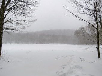
![]()
![]()
![]()
![]()
![]() On Monday, February 22nd I wanted to get out for a longer hike but the weather forecast was calling for up to 6 more inches of snow! I decided that I wanted to do the hike from Alder Lake to Millbrook Ridge and I wanted to do it on this day. I had no idea the condition of the roads or whether the Alder Lake access road and parking would be plowed but I just wanted to get out. The last time I was at Alder Lake I found a nice snowshoe trench developing on the Millbrook Ridge Trail and I hoped that would continue to the top of the ridge. When I started to get ready at 8:00 AM, the temperature was 26 degrees and there was no snow falling. As I started to dress, Sheila came to smell my clothes and then made sure she kept an eye on me. I put on my Patagonia wool long-sleeved zip top with a long-sleeved baselayer since the temperature was cool. I decided to wear my Columbia Titanium insulated pants with a light pair of tights underneath. I wore my Salomon B52 winter boots which are supportive, surprisingly roomy and discontinued. I had recently put a pair of Protalus insoles in these shoes and was anxious to see how they performed. The insoles in most hiking boots are a flimsy and flat piece of material. I also applied a new waterproofing and leather preservative which has proved very effective. I grabbed my Leki external lock poles which I have been using since the spring since twist locks have proved unreliable. I also donned my Mammut hoody which was enough zippers to dump heat when needed. I put on a fleecy orange hat for warmth and wore a light pair of gloves. I also put on my OR Crocodile gaiters to deal with the snow and to keep my lower legs warm. I made sure my Microspikes were in my pack just in case they were needed. I knew I would need snowshoes for traction on the trails and to deal with the new snow that had fallen. I decided to wear my TSL Symbioz snowshoes which have a lot of flex and are good for most terrain except for the steepest ascents on the 35s. They have a ratchet type binding and a televator for steeper climbs. The televator elevates the hiker's heel on ascents and take some strain off the calf muscles. This is a feature that you didn't know you needed until you try it and then it is hard to live without it! I got my gear and Sheila in the car and we left Livingston Manor at 8:30 AM.
On Monday, February 22nd I wanted to get out for a longer hike but the weather forecast was calling for up to 6 more inches of snow! I decided that I wanted to do the hike from Alder Lake to Millbrook Ridge and I wanted to do it on this day. I had no idea the condition of the roads or whether the Alder Lake access road and parking would be plowed but I just wanted to get out. The last time I was at Alder Lake I found a nice snowshoe trench developing on the Millbrook Ridge Trail and I hoped that would continue to the top of the ridge. When I started to get ready at 8:00 AM, the temperature was 26 degrees and there was no snow falling. As I started to dress, Sheila came to smell my clothes and then made sure she kept an eye on me. I put on my Patagonia wool long-sleeved zip top with a long-sleeved baselayer since the temperature was cool. I decided to wear my Columbia Titanium insulated pants with a light pair of tights underneath. I wore my Salomon B52 winter boots which are supportive, surprisingly roomy and discontinued. I had recently put a pair of Protalus insoles in these shoes and was anxious to see how they performed. The insoles in most hiking boots are a flimsy and flat piece of material. I also applied a new waterproofing and leather preservative which has proved very effective. I grabbed my Leki external lock poles which I have been using since the spring since twist locks have proved unreliable. I also donned my Mammut hoody which was enough zippers to dump heat when needed. I put on a fleecy orange hat for warmth and wore a light pair of gloves. I also put on my OR Crocodile gaiters to deal with the snow and to keep my lower legs warm. I made sure my Microspikes were in my pack just in case they were needed. I knew I would need snowshoes for traction on the trails and to deal with the new snow that had fallen. I decided to wear my TSL Symbioz snowshoes which have a lot of flex and are good for most terrain except for the steepest ascents on the 35s. They have a ratchet type binding and a televator for steeper climbs. The televator elevates the hiker's heel on ascents and take some strain off the calf muscles. This is a feature that you didn't know you needed until you try it and then it is hard to live without it! I got my gear and Sheila in the car and we left Livingston Manor at 8:30 AM.
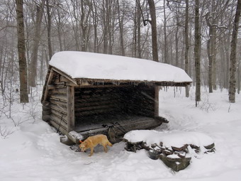 I drove north on Old Route 17 toward Roscoe and turned right on the Beaverkill Road which had some snow cover and was a little narrow with all the snow banks along the road. I followed Beaverkill Road through Lew Beach and then Turnwood. After passing through that small hamlet, I turned left on Alder Creek Road and drove to the access road for Alder Lake. The gate was open and some sand had been put down at some time so driving up the road was relatively easy. The access road in now only one car wide but I was pretty sure I would not meet anybody coming out. When we arrived at the parking area, it was completely empty but well plowed. As I set my GPS and put on my snowshoes, flakes began falling. The temperature was 28 degrees and the wind began to pick up. The snowshoe trench that began at the parking area was well-defined but I could not tell the last time somebody had hiked it which surprised me as I thought it would have been well-traveled over the weekend. We followed the track down to the area near the dam and then followed it along the "beach" to the north side of the lake. I decided I would wait to take pictures as there was nothing very special about the overcast skies with snow falling more heavily. We walked along the trail on the northern side of the lake and I noticed some boot prints and some deep postholes but at least they were few and far between. At .8 miles we turned left onto the Millbrook Ridge Trail that ends on Balsam Lake Mountain. The track was obvious but it did not look like anybody in snowshoes had used it recently. There was a set of boot prints that seemed recent and some postholes when the hiker hit softer snow. At 1 mile into the hike we began the first climb which went quickly after which the trail leveled at 1.5 miles. We passed by a beaver meadow and crossed a small stream before starting the next and somewhat longer climb. Over the next .3 miles we gained 180 feet until the trail level at the beaver pond. Somewhere along the way the boot prints had stopped and I was now trying to follow a snowshoe track that was quickly being covered by snow. It was also difficult for me to see through the snow and the fog and snow on my glasses. I thought about visiting the beaver dam but was concerned at how fast the snow was piling up. The snowshoe track left the marked trail and headed on a more direct route toward the lean-to and I followed.
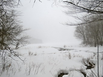 At the lean-to, we took a short rest as I shot a few pictures of the pond and the hills behind it through the falling snow. I got a drink and then we walked out to the snowshoe track which was now back on the main trail. We passed by another beaver meadow without stopping. The trail began to gain some elevation as we climbed toward Millbrook Ridge. We passed by some huge and interesting boulders and glacial erratics. The layers in the sedimentary rock were very clear. It was interesting that many of these rocks had trees growing on top of them in only and few inches of soil. Over the next 1.1 miles we gained 735 feet to the high point on Millbrook Ridge. The snowshoe trench remained good all the way but was hard to see as more snow fell. At 3 miles the direction of the trail switched from heading northeast to southeast. At that point I though I saw some snowshoe tracks coming in from the northwest and assumed it was from someone bushwhacking from Kelly Hollow. When we reached the high point of the ridge there wasn't much to see so we turned around and headed back. I thought that the descent would be much quicker than the ascent but the time was only marginally shorter. The first part of the descent to the beaver meadows was steep and there were some rocks and branches. Sheila was doing a good job removing the branches from the trail. She did not seem to mind the snow or the temperature and would occasionally shake herself off. A few times she bang running ahead and then dashing back toward me. On the way back we bypassed the lean-to and kept a good pace as the entire trip was downhill or flat. The farther we went the deeper the new fallen snow became and the more it obscured my tracks from earlier. We reached the trail junction with the loop trail around Alder Lake and turned right to retrace our path to the parking area. After crossing the IRS bridge, I stopped to take a few shots of the lake. The snow was still falling so hard that I could not see Cradle Rock Ridge across the lake. Once we started in again, we hiked as fast as I could toward the parking area. I kept looking across the lake but could only see the trees and the shore. From the "lawn" I surveyed the scene and decided no pictures were necessary. We walked up the hill to the parking area where I found at least 4 inches of snow on the car. We arrived back in the parking area at 1:10 PM. We had hiked 7.1 miles in 4 hours and 15 minutes with several stops along the way. The elevation gain was 1480 feet and this counted as a 3500 foot peak according to club rules. On the way home the roads were barely plowed and there was very little sand. I chased a coyote for about a quarter mile down Alder Creek Road. I decided not to chance Johnson Mountain on the Beaverkill Road so I headed to Roscoe on the back roads. These roads had been plowed and sanded. I took State Route 17 from Roscoe to Manor and found very little traffic.
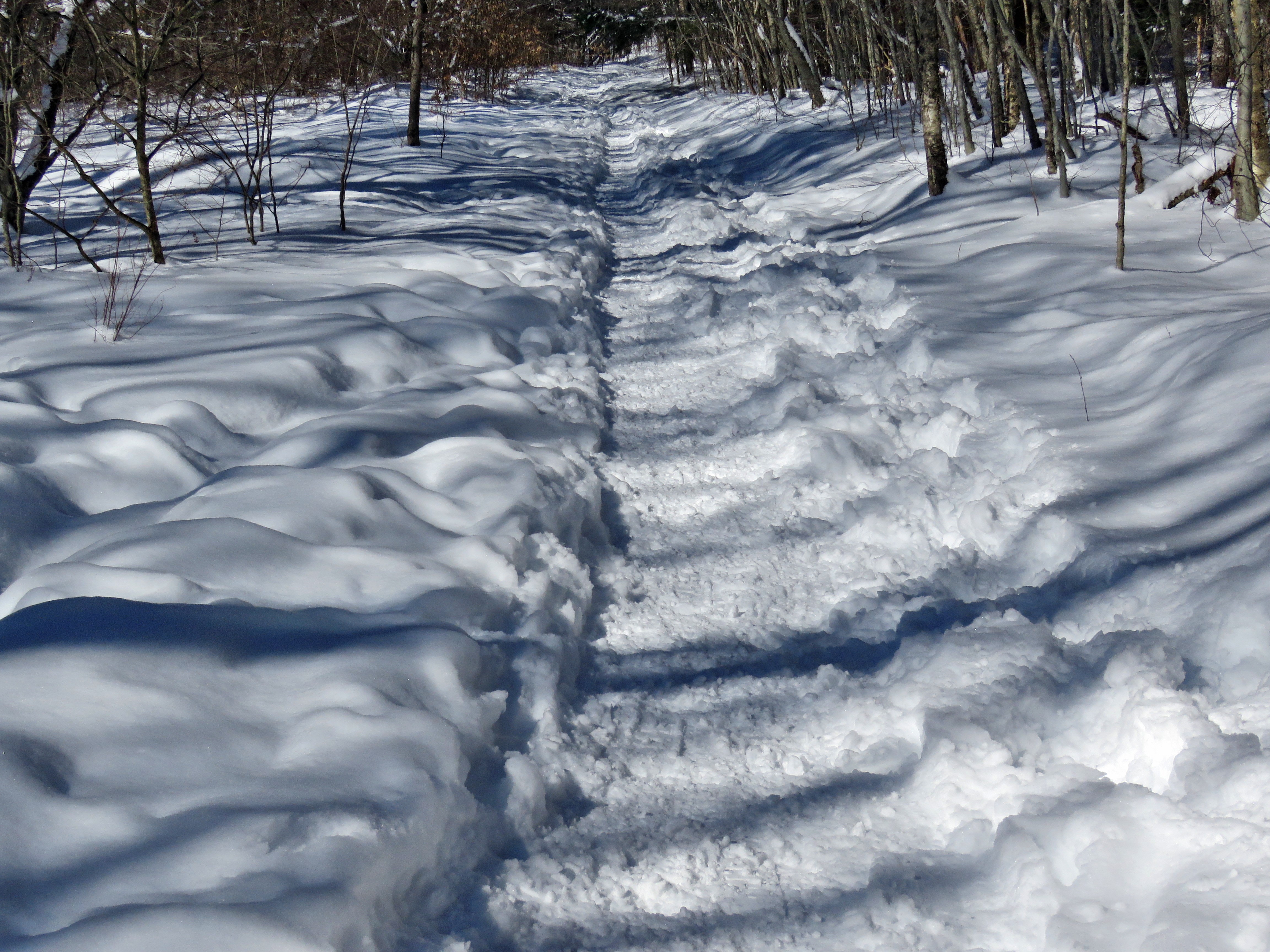
![]()
![]()
![]()
![]()
![]() On Monday, January 18th, I was ready to get in a longer hike after returning from church and had decided to hike the big loop around Frick and Hodge Ponds. I knew some of this loop would be packed by snowmobiles so I though I could do it even if I had to break some trail. When I mentioned hiking to Cindy, she said she would like to come along even after I outlined my route. When we were starting to get ready at 12:30 PM the temperature was 30 degrees but I suspected it would be colder at the trailhead. As I started gathering my equipment and getting dressed, Sheila was very quiet but did not let me out of her sight. I put on my Mammut long-sleeved crew top with a long-sleeved baselayer since the temperature was cool. I decided to wear my Columbia Titanium insulated pants but didn't bother with a baselayer. I wore my Salomon B52 winter boots which are supportive, surprisingly roomy and discontinued. I had recently put a pair of Protalus insoles in these shoes and was anxious to see how they performed. The insoles in most hiking boots are a flimsy and flat piece of material. I also applied a new waterproofing and leather preservative which has proved very effective. I grabbed my Leki external lock poles which I have been using since the spring since twist locks have proved unreliable. I also donned my Mammut hoody which was enough zippers to dump heat when needed. I put on a fleecy orange hat for warmth and wore a light pair of gloves. I also put on my OR Crocodile gaiters to deal with the snow and to keep my lower legs warm. I made sure my Microspikes were in my pack just in case they were needed. Cindy and I decided to take snowshoes knowing the snow would not be deep but that wearing them would preserve any track that was present or help us to create one. Cindy took her Tubb's Flex VRT which have the Boa binding. This system uses a thin steel cable system and a ratchet wheel which tightens it to give a custom fit and a secure binding. These snowshoes also have a televator to elevate the hiker's heel on ascents and take some strain off the calf muscles. This is a feature that you didn't know you needed until you try it and then it is hard to live without it! I decided to wear my TSL Symbioz snowshoes which have a lot of flex and are good for most terrain except for the steepest ascents on the 35s. They have a ratchet type binding and a televator for steeper climbs. We got our gear and Sheila in my car and left Livingston Manor at 12:50 PM. I drove out the DeBruce Road about 6 miles to Mongaup Road and turned left to continue up the road to the point where it splits. I stayed left on Beech Mountain Road and drove to the Frick Pond trailhead. When we arrived at the parking areas, we found the smaller lot plowed but the larger one was still covered in freshly fallen powder. The smaller lot was full of cars that seemed to have been parked haphazardly with no real plan! There was only one car in the larger lot so I pulled into that one and parked without a problem. As Cindy and I were getting ready, one car pulled out of the smaller lot. The skies were a beautiful blue but lacked any white clouds for contrast. The temperature right at 26 degrees with a slight breeze blowing. I set my GPS and we both put on our snowshoes. We carried our spikes although I could not think of a place we would use them.
On Monday, January 18th, I was ready to get in a longer hike after returning from church and had decided to hike the big loop around Frick and Hodge Ponds. I knew some of this loop would be packed by snowmobiles so I though I could do it even if I had to break some trail. When I mentioned hiking to Cindy, she said she would like to come along even after I outlined my route. When we were starting to get ready at 12:30 PM the temperature was 30 degrees but I suspected it would be colder at the trailhead. As I started gathering my equipment and getting dressed, Sheila was very quiet but did not let me out of her sight. I put on my Mammut long-sleeved crew top with a long-sleeved baselayer since the temperature was cool. I decided to wear my Columbia Titanium insulated pants but didn't bother with a baselayer. I wore my Salomon B52 winter boots which are supportive, surprisingly roomy and discontinued. I had recently put a pair of Protalus insoles in these shoes and was anxious to see how they performed. The insoles in most hiking boots are a flimsy and flat piece of material. I also applied a new waterproofing and leather preservative which has proved very effective. I grabbed my Leki external lock poles which I have been using since the spring since twist locks have proved unreliable. I also donned my Mammut hoody which was enough zippers to dump heat when needed. I put on a fleecy orange hat for warmth and wore a light pair of gloves. I also put on my OR Crocodile gaiters to deal with the snow and to keep my lower legs warm. I made sure my Microspikes were in my pack just in case they were needed. Cindy and I decided to take snowshoes knowing the snow would not be deep but that wearing them would preserve any track that was present or help us to create one. Cindy took her Tubb's Flex VRT which have the Boa binding. This system uses a thin steel cable system and a ratchet wheel which tightens it to give a custom fit and a secure binding. These snowshoes also have a televator to elevate the hiker's heel on ascents and take some strain off the calf muscles. This is a feature that you didn't know you needed until you try it and then it is hard to live without it! I decided to wear my TSL Symbioz snowshoes which have a lot of flex and are good for most terrain except for the steepest ascents on the 35s. They have a ratchet type binding and a televator for steeper climbs. We got our gear and Sheila in my car and left Livingston Manor at 12:50 PM. I drove out the DeBruce Road about 6 miles to Mongaup Road and turned left to continue up the road to the point where it splits. I stayed left on Beech Mountain Road and drove to the Frick Pond trailhead. When we arrived at the parking areas, we found the smaller lot plowed but the larger one was still covered in freshly fallen powder. The smaller lot was full of cars that seemed to have been parked haphazardly with no real plan! There was only one car in the larger lot so I pulled into that one and parked without a problem. As Cindy and I were getting ready, one car pulled out of the smaller lot. The skies were a beautiful blue but lacked any white clouds for contrast. The temperature right at 26 degrees with a slight breeze blowing. I set my GPS and we both put on our snowshoes. We carried our spikes although I could not think of a place we would use them.
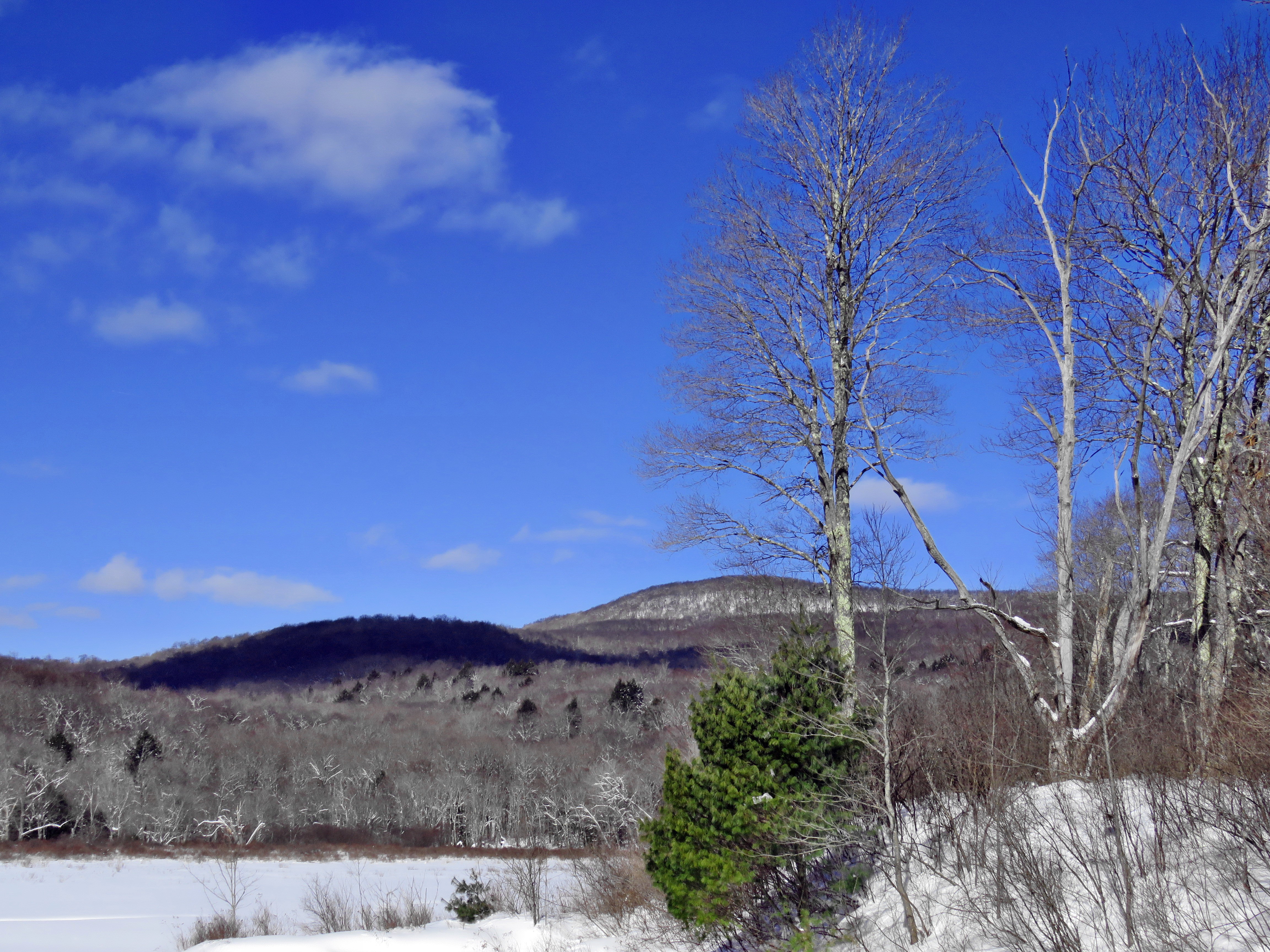 We started out the Quick Lake Trail from the parking area to the register and found that many people had been on the trail and it seemed as if all had worn snowshoes! This was a pleasant surprise as a nice snowshoe track had developed. There was about 4 inches of new powder with a foot or more of base off the trails. We turned left at the register onto the woods road that heads out to the trail system. The woods road was completely covered in snow and had a good snowshoe trench with the only open water in the small streams that transect the trail. The snowshoes were working well and I did not notice that walking was much harder with them. At Gravestone Junction we stayed left on the Quick Lake trail heading toward the bridge at the outlet to Frick Pond. When we arrived at the bridge, I almost passed in taking some pictures but decided to stop as I always due and snap some shots. As I was packing up Sheila alerted and we could hear voices coming from the west side of the pond. We waited and a group of four people came toward us. One, who was wearing snowshoes, crossed the bridge and greeted us. Three more stopped on the bridge and we waited fro them to cross. Since they were not moving, we eventually crossed and I noticed one had snowshoes and one did not. Although the track was well-packed, I was disappointed that someone would not wear snowshoes just to be sure they did not chew up the trench. We continued over the bridge and along the west side of Frick Pond and immediately met a young couple neither of whom had snowshoes. They decided to walk off the trail into the deep snow even though she was carrying a baby. We greeted them as we passed and I mentioned that snowshoes made the hike much easier. At the junction with the Big Rock Trail, we headed left on the Quick Lake Trail where only one other person had hiked recently and it was obvious they had not worn snowshoes! I had broken a track here sometime before and I could still see it. The barebooter had taken advantage of my work and had walked right down the middle of the track leaving holes from 2 to 10 inches deep. The snow was now between 12 and 24 inches and the footprints were annoying. I tried to widen the narrow track and smooth over the depressions. We walked through the spruce tunnel and came to the small stream across the trail. There was a snow bridge over the water and we crossed easily. I noticed at this point that the holes had stopped but there was a rather well-defined snowshoe track. As we walked we tried to widen and deepen the track to a nice trench. The walk up the trail was pretty easy but we did move some branches out of the way. There was no open water or soft mud to impede our progress. I was pretty sure when we got to Iron Wheel Junction there would be snowmobile tracks which would make the walking easier.
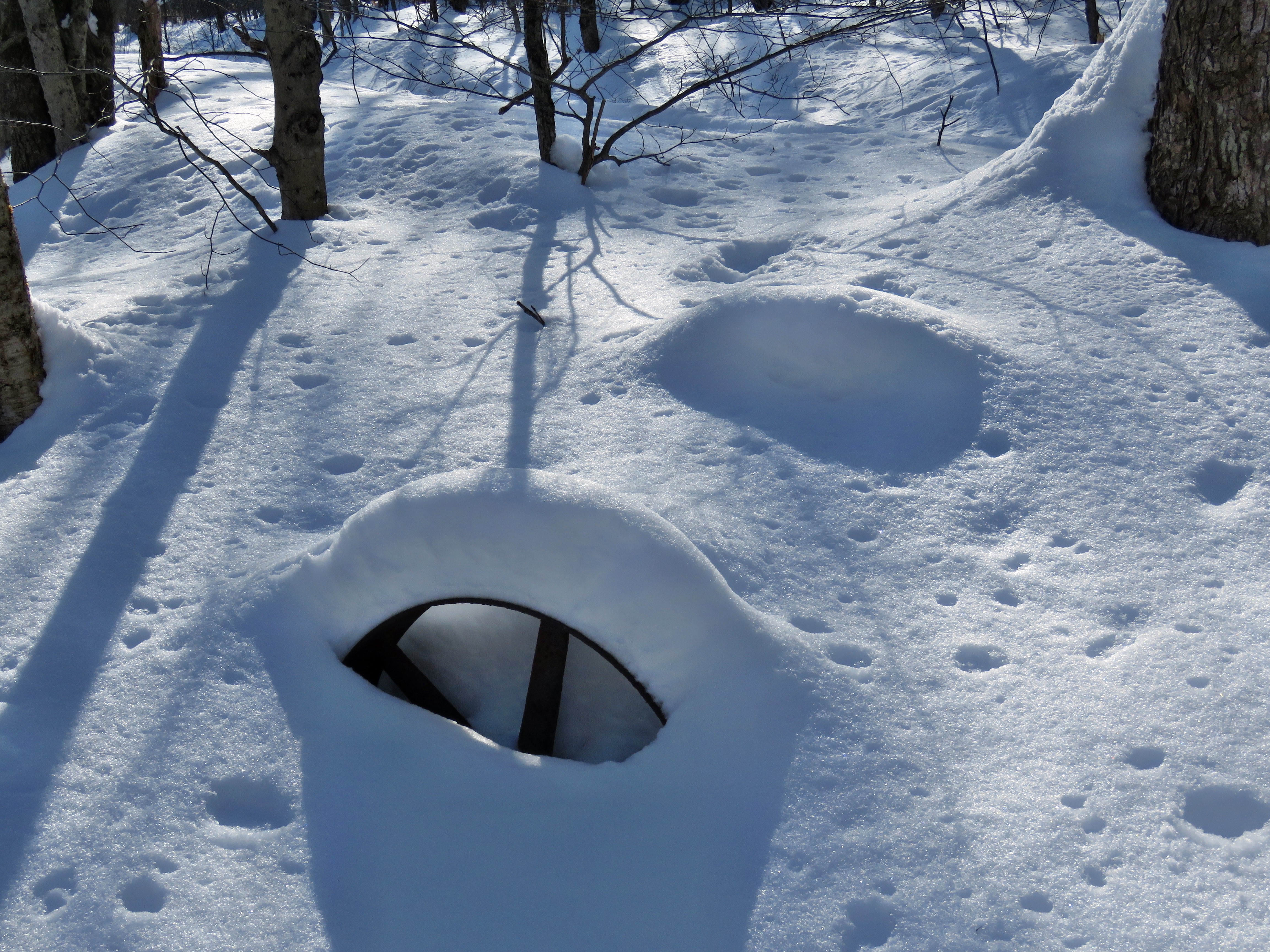 When we got to the junction, we could hardly see the iron wheel as it was almost completely covered by snow. Some drifts here were almost three feet deep! The Logger's Loop was completely packed by multiple snowmobile passes. I took a few shots and then was ready to turn left to head toward Hodge Pond. At this point Cindy informed me that she wanted to turn right to take a much shorter route. I knew this might happen as it often does but I was not happy to be hiking less than 4 miles when I had planned on 6. We turned right and began following the pack snowmobile trail which made for very easy walking. As we walked we continued to clear some small branches. After a short distance, Sheila alerted and we both heard the sound of snowmobiles approaching from ahead. We walked off the trail as the three machines approached and slowed as they passed us. We continued to set a good pace along the open trail. It was only a few minutes until the snowmobiles returned and I wondered why they had not gone farther on the well-groomed trails. The skies continued to be blue and cloudless with a bright sun shining down on us. We came to the large cherry tree that had broken off high up and fallen so that it was arching across the trail. This tree was not blocking the trail and it was clear it was not coming down soon. We heard snowmobiles again and walked off the trail to let two different machines pass us. We passed by the seasonal pond on the left side of the trail and continued downhill to Times Square. We continued straight across Times Square to stay on the Logger's Loop. We started the uphill and could see two hikers ahead of us who seemed to be using snowshoes. Although the trail is slightly uphill Sheila and I were setting a fast pace and the other hikers had stopped. We soon passed them offering a brief "Hello". Cindy was a little farther behind but she also passed them and I slowed a little so she could catch up. We continued walking on the trail and crested the hill to walk out to Gravestone Junction. We turned left at the Gravestone Junction and headed back to the car on the woods road. At the trail register, we turned right to stay on the Quick Lake Trail back to our car. It was 3:25 PM and we had spent 2 hour and 5 minutes hiking 3.7 miles on snowshoes. The elevation gain was a modest 395 feet. The temperature had risen to 28 degrees.
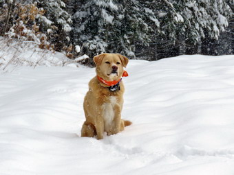
![]()
![]()
![]()
![]()
![]() On Friday, February 19th a two day snowstorm extending from early Thursday through late Friday morning had dropped 6 inches of snow and some ice on downtown Livingston Manor. Surprisingly there had been only a couple of ambulance calls in the middle of the storm. I did not go out on Thursday as I did not want to chance being an accident on the slippery back roads. Friday morning the roads in town looked better but I knew the back roads would still be dangerous. I did not want to drive anywhere as the roads to hiking areas and the parking areas would not be plowed. I decided to go across the street and hike on Round Top. I asked Cindy if she wanted to go but she declines. Sheila, on the other hand, thought hiking was a great idea. I started getting ready at 10:30 AM when the temperature was a warm 28 degrees with overcast skies and some light snow still hanging around. I got dressed in my Mammut crew top with a light baselayer underneath. I put on my Mammut long-sleeved crew top with a long-sleeved baselayer. I decided to wear my Columbia Titanium insulated pants without tights underneath. I wore my Salomon B52 winter boots which are supportive, surprisingly roomy and discontinued. I had recently put a pair of Protalus insoles in these shoes and was anxious to see how they performed. The insoles in most hiking boots are a flimsy and flat piece of material. I also applied a new waterproofing and leather preservative which has proved very effective. I grabbed my Leki external lock poles which I have been using since the spring since twist locks have proved unreliable. I also donned my Mammut hoody which was enough zippers to dump heat when needed. I put on a fleecy orange hat for warmth and wore a light pair of gloves. I also put on my OR Crocodile gaiters which some almost to my knee to deal with the snow and to keep my lower legs warm. I decided to wear snowshoes which would keep the trails in good shape by setting a nice track. I decided to wear my TSL Symbioz snowshoes which have a lot of flex and are good for most terrain except for the steepest ascents on the 35s. They have a ratchet type binding and a televator for steeper climbs. The televator elevates the hiker's heel on ascents. This is a feature that you didn't know you needed until you try it and then it is hard to live without it! Sheila kept me in sight as I got ready to go making sure she would not be forgotten. I took my pack with me as it is the easiest way to carry my camera. We stepped out of the house at 10:50 PM. After I put on my snowshoes, I grabbed Sheila's leash from the car and put it on her to safely cross the street. We walked up the driveway and crossed the street. We mounted the snow bank left by the plow with some difficulty and headed across the field by the church to the hill that ascends to the trailhead. I let Sheila off her leash and she went to the church parking lot to look around. I think she was looking for Lisa who we often meet there. As we started up the hill, I realized that there was a lot of snow! I could pick out the track I had set before the storm and this made walking easier. We began the ascent of the steepest hill behind the church. The hill is short but gets the circulation pumping and is the steepest and longest climb on the "trail." I had already let Sheila off her leash so that I could use my poles to get up the hill. Sheila immediately began to bound up the hill with me following close behind. We stopped in the middle of the hill so that I could take pictures toward the "Flats" to the southeast. The cemetery was covered in snow and all the trees on the surrounding hills were snow clad. When we got to the top of the hill, we stopped to look around at the hills around town. I took some more pictures across the valley to "Beer Mountain" and some to the north and west. We started on the trail by turning left at the trailhead. There were no tracks on the trails as we were the first ones out to hike.
On Friday, February 19th a two day snowstorm extending from early Thursday through late Friday morning had dropped 6 inches of snow and some ice on downtown Livingston Manor. Surprisingly there had been only a couple of ambulance calls in the middle of the storm. I did not go out on Thursday as I did not want to chance being an accident on the slippery back roads. Friday morning the roads in town looked better but I knew the back roads would still be dangerous. I did not want to drive anywhere as the roads to hiking areas and the parking areas would not be plowed. I decided to go across the street and hike on Round Top. I asked Cindy if she wanted to go but she declines. Sheila, on the other hand, thought hiking was a great idea. I started getting ready at 10:30 AM when the temperature was a warm 28 degrees with overcast skies and some light snow still hanging around. I got dressed in my Mammut crew top with a light baselayer underneath. I put on my Mammut long-sleeved crew top with a long-sleeved baselayer. I decided to wear my Columbia Titanium insulated pants without tights underneath. I wore my Salomon B52 winter boots which are supportive, surprisingly roomy and discontinued. I had recently put a pair of Protalus insoles in these shoes and was anxious to see how they performed. The insoles in most hiking boots are a flimsy and flat piece of material. I also applied a new waterproofing and leather preservative which has proved very effective. I grabbed my Leki external lock poles which I have been using since the spring since twist locks have proved unreliable. I also donned my Mammut hoody which was enough zippers to dump heat when needed. I put on a fleecy orange hat for warmth and wore a light pair of gloves. I also put on my OR Crocodile gaiters which some almost to my knee to deal with the snow and to keep my lower legs warm. I decided to wear snowshoes which would keep the trails in good shape by setting a nice track. I decided to wear my TSL Symbioz snowshoes which have a lot of flex and are good for most terrain except for the steepest ascents on the 35s. They have a ratchet type binding and a televator for steeper climbs. The televator elevates the hiker's heel on ascents. This is a feature that you didn't know you needed until you try it and then it is hard to live without it! Sheila kept me in sight as I got ready to go making sure she would not be forgotten. I took my pack with me as it is the easiest way to carry my camera. We stepped out of the house at 10:50 PM. After I put on my snowshoes, I grabbed Sheila's leash from the car and put it on her to safely cross the street. We walked up the driveway and crossed the street. We mounted the snow bank left by the plow with some difficulty and headed across the field by the church to the hill that ascends to the trailhead. I let Sheila off her leash and she went to the church parking lot to look around. I think she was looking for Lisa who we often meet there. As we started up the hill, I realized that there was a lot of snow! I could pick out the track I had set before the storm and this made walking easier. We began the ascent of the steepest hill behind the church. The hill is short but gets the circulation pumping and is the steepest and longest climb on the "trail." I had already let Sheila off her leash so that I could use my poles to get up the hill. Sheila immediately began to bound up the hill with me following close behind. We stopped in the middle of the hill so that I could take pictures toward the "Flats" to the southeast. The cemetery was covered in snow and all the trees on the surrounding hills were snow clad. When we got to the top of the hill, we stopped to look around at the hills around town. I took some more pictures across the valley to "Beer Mountain" and some to the north and west. We started on the trail by turning left at the trailhead. There were no tracks on the trails as we were the first ones out to hike.
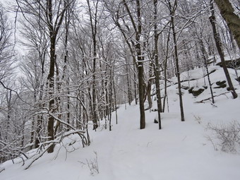 I knew that other people were using the trails from comments on Facebook. The track was pretty well preserved but I noticed some boot prints and postholes to the side of the track. At the first trail junction, we stopped so that I could take some pictures of the trails and the impressive cliffs and ledges covered in snow. I put my camera away and we continued straight ahead up the hill toward the viewpoint. Again, the climb up the hill was not particularly tiring as we had the track and not that much new snow. At the viewpoint, Sheila and I headed to the left and walked out to the overhanging rock shelf that forms the lookout. Even though it was still snowing, I took pictures of town and the school. I also took some shots of the hills around town. When I was done, we walked to the main trail and followed the yellow trail as it turned right and headed up the gentle hill through the hardwood forest with trees encased in snow. There was a slight breeze which would occasionally blow some snow off the trees. At the first trail junction with the blue trail, we turned right and followed the yellow trail along the base of Round Top. This section was easier, even though the snow was a little deeper, as it was flat. At the next junction, we turned left and started up to the summit of Round Top on the blue trail. We bypassed the white crossover trail and continued up and over the summit. When we started down the other side, I decided we would skip the new switchback on the blue trail and just continue down the hill. I was able to get a pretty good glide on the snow but I had to watch my speed and balance. The steepest part of the hill was tricky but the poles helped me to keep my balance and get down without falling. At the bottom of the hill we turned left on the yellow trail, walked along the base of Round Top. I was surprised at how much easier it was walking in the trail I had just broken. At the trail junction with the blue trail, we turned right to walk down to the woods road. It was a snap to walk downhill and out the woods road. It was obvious Sheila felt the same way as she was running and bounding ahead of me. We walked the woods road out to the first trail junction. We immediately turned around and walked back up the woods road to the junction with the blue trail. I had to call Sheila back as she was following game trails and inspecting the "caves". We turned left and walked along the yellow trail following the base of the Round Top summit. At the next junction we turned right and started up the steeper side of the hill on the blue trail. This time we followed the switchback in the blue trail which was not broken out. It was also obvious that not many people had taken this trail as the track was hard to find. We followed the switchback as it turned back toward the main trail. We turned right on the main trail and right again almost immediately on the white-blazed crossover trail. This too was less used than the main trails and I had to look closely to find the track. On the other side of the hill we came to the main trail and turned right to hike downhill to the junction with the yellow trail. We turned right on the yellow trail and followed it along the base of Round Top once again. At the junction with the blue trail we turned to the left to stay on the yellow trail to the lookout. At the lookout we followed the yellow trail as it turned right and descended to the first trail junction. I was interested to see that the trail had begun to fill in with the fine snow that was falling. We walked out to the trailhead and turned right to walk to the bottom of the hill. We headed across the church parking lot and the field next to it. We crossed the road to our driveway and were home by 12:40 PM after hiking a little over 2 miles in 1 hour and 45 minutes.
By the time it took to hike this figure 8, the difficulty was twice that of the same route without snow. We walked out to the trailhead and down the hill. I put Sheila on her leash in the church parking lot and we crossed the street to our driveway. We were home by 10:25 AM after hiking a little over a mile in almost an hour and a half!
I knew that other people were using the trails from comments on Facebook. The track was pretty well preserved but I noticed some boot prints and postholes to the side of the track. At the first trail junction, we stopped so that I could take some pictures of the trails and the impressive cliffs and ledges covered in snow. I put my camera away and we continued straight ahead up the hill toward the viewpoint. Again, the climb up the hill was not particularly tiring as we had the track and not that much new snow. At the viewpoint, Sheila and I headed to the left and walked out to the overhanging rock shelf that forms the lookout. Even though it was still snowing, I took pictures of town and the school. I also took some shots of the hills around town. When I was done, we walked to the main trail and followed the yellow trail as it turned right and headed up the gentle hill through the hardwood forest with trees encased in snow. There was a slight breeze which would occasionally blow some snow off the trees. At the first trail junction with the blue trail, we turned right and followed the yellow trail along the base of Round Top. This section was easier, even though the snow was a little deeper, as it was flat. At the next junction, we turned left and started up to the summit of Round Top on the blue trail. We bypassed the white crossover trail and continued up and over the summit. When we started down the other side, I decided we would skip the new switchback on the blue trail and just continue down the hill. I was able to get a pretty good glide on the snow but I had to watch my speed and balance. The steepest part of the hill was tricky but the poles helped me to keep my balance and get down without falling. At the bottom of the hill we turned left on the yellow trail, walked along the base of Round Top. I was surprised at how much easier it was walking in the trail I had just broken. At the trail junction with the blue trail, we turned right to walk down to the woods road. It was a snap to walk downhill and out the woods road. It was obvious Sheila felt the same way as she was running and bounding ahead of me. We walked the woods road out to the first trail junction. We immediately turned around and walked back up the woods road to the junction with the blue trail. I had to call Sheila back as she was following game trails and inspecting the "caves". We turned left and walked along the yellow trail following the base of the Round Top summit. At the next junction we turned right and started up the steeper side of the hill on the blue trail. This time we followed the switchback in the blue trail which was not broken out. It was also obvious that not many people had taken this trail as the track was hard to find. We followed the switchback as it turned back toward the main trail. We turned right on the main trail and right again almost immediately on the white-blazed crossover trail. This too was less used than the main trails and I had to look closely to find the track. On the other side of the hill we came to the main trail and turned right to hike downhill to the junction with the yellow trail. We turned right on the yellow trail and followed it along the base of Round Top once again. At the junction with the blue trail we turned to the left to stay on the yellow trail to the lookout. At the lookout we followed the yellow trail as it turned right and descended to the first trail junction. I was interested to see that the trail had begun to fill in with the fine snow that was falling. We walked out to the trailhead and turned right to walk to the bottom of the hill. We headed across the church parking lot and the field next to it. We crossed the road to our driveway and were home by 12:40 PM after hiking a little over 2 miles in 1 hour and 45 minutes.
By the time it took to hike this figure 8, the difficulty was twice that of the same route without snow. We walked out to the trailhead and down the hill. I put Sheila on her leash in the church parking lot and we crossed the street to our driveway. We were home by 10:25 AM after hiking a little over a mile in almost an hour and a half!
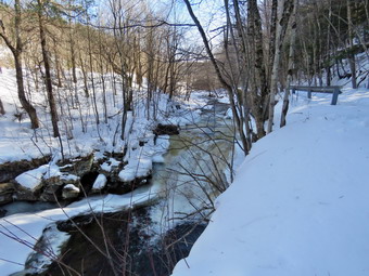
![]()
![]()
![]()
![]()
![]() On Wednesday, February 17th I wanted to get out for hike but did not want to go too far from home. I was still letting my back recover and I had an early track practice in the afternoon. I knew that the deep freeze overnight had probably hardened everything on the trails making snowshoes unnecessary and any postholes dangerous. I asked Cindy if she wanted to take a walk and she said "Yes". We agreed to hike the Parksville Rail Trail which is short, less than 3 miles, but has a nice waterfall. As we started to get ready at 10:30 AM the temperature was still 18 degrees. I don't like to take Sheila out too often when the temperature is below 20 degrees but she has never shown any ill effects from it and this would be a short hike. I put on my long-sleeved Patagonia wool zip top with a light long-sleeved baselayer underneath. I decided to wear my Columbia Titanium insulated pants to keep the chill away with a pair of light tights underneath. I wore my Salomon B-52 insulated boots as they keep my feet warm and dry and work well with snowshoes. I had recently put a pair of Protalus insoles in these shoes and was anxious to see how they performed. The insoles in most hiking boots are a flimsy and flat piece of material. I also applied a new waterproofing and leather preservative which has proved very effective. I went with my new Follow Hollow alpaca sock which are thick and warm and come to my midcalf. I grabbed a pair of Leki external lock poles I have been using all season. I also put on my OR Crocodile gaiters. Finally, I donned my Mammut hoody which blocks the wind and keeps me warm but has enough zippers to dump heat when needed. I put on a fleecy orange hat for warmth. For snowshoes Cindy and I decided to take our Tubbs Flex VRT which have the Boa binding. This system uses a thin steel cable system and a ratchet wheel which tightens it to give a custom fit and a secure binding. These snowshoes also have a televator to elevate the hiker's heel on ascents. This is a feature that you didn't know you needed until you try it and then it is hard to live without it! We knew these might not be necessary so we also made sure we had spikes with us. At 10:55 we put our gear in the car and Sheila in the back seat. I headed out Old Route 17 across the Flats and then took Old Route 17 and Service Road to the point where they meet Fox Mountain Road. Just after this intersection is the western parking area for the rail trail. We were surprised to see that the parking lot was not plowed. It is a shame that the lot was inaccessible as it would take about 15 minutes to plow and allow people access to the rail trail from both ends. I continued to drive into Parksville turning right at the stop sign on Short Avenue. I noticed the large lot at the corner was plowed but I turned right on Main Street and parked on the side of the street where there was plenty of room. My intention was to check out the trail and then park in the other lot. I got out of the car and walked to the point where the trail entered the woods. The snow was so hard I made no dent in it. I did find that the trail was chewed up by ignorant people who did not know that they should wear snowshoes. Many of them had come out the day before when the temperatures were above freezing. They had sunk deeply into the soft snow and ice. The flash freeze overnight had turned their mistake into a minefield.
On Wednesday, February 17th I wanted to get out for hike but did not want to go too far from home. I was still letting my back recover and I had an early track practice in the afternoon. I knew that the deep freeze overnight had probably hardened everything on the trails making snowshoes unnecessary and any postholes dangerous. I asked Cindy if she wanted to take a walk and she said "Yes". We agreed to hike the Parksville Rail Trail which is short, less than 3 miles, but has a nice waterfall. As we started to get ready at 10:30 AM the temperature was still 18 degrees. I don't like to take Sheila out too often when the temperature is below 20 degrees but she has never shown any ill effects from it and this would be a short hike. I put on my long-sleeved Patagonia wool zip top with a light long-sleeved baselayer underneath. I decided to wear my Columbia Titanium insulated pants to keep the chill away with a pair of light tights underneath. I wore my Salomon B-52 insulated boots as they keep my feet warm and dry and work well with snowshoes. I had recently put a pair of Protalus insoles in these shoes and was anxious to see how they performed. The insoles in most hiking boots are a flimsy and flat piece of material. I also applied a new waterproofing and leather preservative which has proved very effective. I went with my new Follow Hollow alpaca sock which are thick and warm and come to my midcalf. I grabbed a pair of Leki external lock poles I have been using all season. I also put on my OR Crocodile gaiters. Finally, I donned my Mammut hoody which blocks the wind and keeps me warm but has enough zippers to dump heat when needed. I put on a fleecy orange hat for warmth. For snowshoes Cindy and I decided to take our Tubbs Flex VRT which have the Boa binding. This system uses a thin steel cable system and a ratchet wheel which tightens it to give a custom fit and a secure binding. These snowshoes also have a televator to elevate the hiker's heel on ascents. This is a feature that you didn't know you needed until you try it and then it is hard to live without it! We knew these might not be necessary so we also made sure we had spikes with us. At 10:55 we put our gear in the car and Sheila in the back seat. I headed out Old Route 17 across the Flats and then took Old Route 17 and Service Road to the point where they meet Fox Mountain Road. Just after this intersection is the western parking area for the rail trail. We were surprised to see that the parking lot was not plowed. It is a shame that the lot was inaccessible as it would take about 15 minutes to plow and allow people access to the rail trail from both ends. I continued to drive into Parksville turning right at the stop sign on Short Avenue. I noticed the large lot at the corner was plowed but I turned right on Main Street and parked on the side of the street where there was plenty of room. My intention was to check out the trail and then park in the other lot. I got out of the car and walked to the point where the trail entered the woods. The snow was so hard I made no dent in it. I did find that the trail was chewed up by ignorant people who did not know that they should wear snowshoes. Many of them had come out the day before when the temperatures were above freezing. They had sunk deeply into the soft snow and ice. The flash freeze overnight had turned their mistake into a minefield.
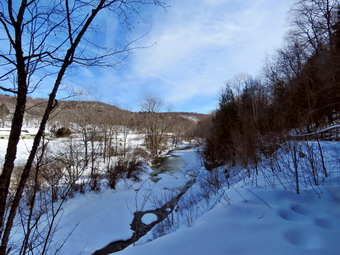 We decided to park where we were as it was closer to the trailhead and there were no other cars around. We also decided that we did not need snowshoes. Cindy put on her spikes but I decide to carry mine with me. I set my GPS and we started on the trail at 11:10 AM with the temperature right at 20 degrees with a slight breeze blowing. The boot prints in the trail were every bit as annoying as I thought they might be and they were spread across the entire width of the trail. We were careful and avoided the worst ones as we hiked along the almost flat trail. It was colder under the trees but as long as we kept moving we were warm enough. At about .4 miles we came to the Parksville Falls. The areas above the falls had a lot of ice with water flowing over it. The water was so clear we could see the bedrock beneath the flowing water. The volume of the stream was impressive. I took some shot form the trail and then walked down a path to the edge of the stream. I took some more pictures upstream and then took some of the water going over the top of the falls. When I was done, I walked back up to the main trail and continue for a short distance to the area at the top of the falls. I took a few shots of the falls and then decided I wanted a closer look. I worked my way down a path through some deep snow to an area in front of the falls. I was not able to get the direct view that I wanted because the rocks I normally use as a base were all covered in ice. I did take some more shots and then worked my way up to the main trail. Cindy was already well ahead of me trying to keep warm by moving. Sheila spent her time running up and down the trail between us. At .8 miles we crossed several bridges over an area that has some seasonal streams and drainage off State Route 17. At the end of the bridges I stopped to take some long distance shots down the stream. The skies were so blue and the contrast with the snow-covered landscape was dramatic. After taking some pictures, I continued along the trail westward toward the trailhead near Fox Mountain Road. I noticed that after the bridges there were few if any boot prints and most were just prints with deep holes. As we approached the trailhead parking, I met Cindy and Sheila coming toward us. Cindy decided to head back to the car without me so I kept Sheila with me. We continued to walk along the trail and broke out into the sun where it seemed so much warmer. We walked to the trailhead and then turned around to start back. Sheila kept whining and running ahead to find Cindy but she came back when I called. I did not plan to stop on the way back but did pause at one point to take some pictures of the deep postholes in the trail. As we approached the bridges, Sheila alerted and I saw a family with a dog ahead of us. I put Sheila on her leash and we slowed down a little as I cleared some branches that had come down in the ice storm. We continued to walk out the trail just behind the family. We were back at the car at 12:45 PM after hiking 2.8 miles in 1.5 hours. The trail could be dangerous after the next snow covers up the frozen postholes.
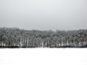
![]()
![]()
![]()
![]()
![]() On Monday, February 17th I wanted to get out for a longer hike than I had been doing to "test" my back. My problem was the dire forecast which mad me think I should stay close to home. I had really wanted to do some of the Scary 19 list but decided they were too far away. I thought about Millbrook Ridge but finally decided to go to the Frick Pond area to see how my snowshoe track had held up. At 10:15 AM I decided to stop waiting on the weather and start to get dressed to hike. As I was getting ready Sheila was watching me intently as we had not hiked for two days. The temperature was 28 degrees and there was light snow falling mixed with something else. I put on my Mammut long-sleeved crew top with a long-sleeved baselayer since the temperature was just cool. I decided to wear my Columbia Titanium insulated pants with a pair of light Mountain Hardwear tights underneath. I wore my Salomon B52 winter boots which are supportive, surprisingly roomy and discontinued. I had recently put a pair of Protalus insoles in these shoes and was anxious to see how they performed. The insoles in most hiking boots are a flimsy and flat piece of material. I also applied a new waterproofing and leather preservative which has proved very effective. I grabbed my Leki external lock poles which I have been using since twist locks have proved unreliable. I also donned my Mammut hoody which was enough zippers to dump heat when needed. I also made sure that I put on my OR Crocodile gaiters since I was not sure of the snow depth. I put on a fleecy orange hat for warmth and wore a light pair of gloves. I decided to wear my TSL Symbioz snowshoes which have a lot of flex and are good for most terrain except for the steepest ascents on the 35s. They have a ratchet type binding and a televator for steeper climbs. The televator elevates the hiker's heel on ascents which reduces calf strain and allows the toe crampon to get a better bite. This is a feature that you didn't know you needed until you try it and then it is hard to live without it! I put my gear in the car and left the house at about 10:45 AM with a very happy Sheila in the backseat. I drove out the Debruce Road and found the surface was in good shape. At about 6 miles I turned left onto Mongaup Pond Road and continued to where the road split. This road was covered in snow with some ice so I took it slow. I turned left onto Beech Mountain Road, and drove to the parking areas at Frick Pond. There were no cars parked in either lot which I found strange as it was a Federal holiday I pulled into the small lot and parked. The car thermometer read 28 degrees as I set my GPS. The skies were overcast and there was still stuff falling from the skies but there was no wind. The dog from the cabin at the end of the road was again running loose and came to visit us with his owner yelling to him to no avail. The dog is pretty smart but the wonder is a slow leaner!
On Monday, February 17th I wanted to get out for a longer hike than I had been doing to "test" my back. My problem was the dire forecast which mad me think I should stay close to home. I had really wanted to do some of the Scary 19 list but decided they were too far away. I thought about Millbrook Ridge but finally decided to go to the Frick Pond area to see how my snowshoe track had held up. At 10:15 AM I decided to stop waiting on the weather and start to get dressed to hike. As I was getting ready Sheila was watching me intently as we had not hiked for two days. The temperature was 28 degrees and there was light snow falling mixed with something else. I put on my Mammut long-sleeved crew top with a long-sleeved baselayer since the temperature was just cool. I decided to wear my Columbia Titanium insulated pants with a pair of light Mountain Hardwear tights underneath. I wore my Salomon B52 winter boots which are supportive, surprisingly roomy and discontinued. I had recently put a pair of Protalus insoles in these shoes and was anxious to see how they performed. The insoles in most hiking boots are a flimsy and flat piece of material. I also applied a new waterproofing and leather preservative which has proved very effective. I grabbed my Leki external lock poles which I have been using since twist locks have proved unreliable. I also donned my Mammut hoody which was enough zippers to dump heat when needed. I also made sure that I put on my OR Crocodile gaiters since I was not sure of the snow depth. I put on a fleecy orange hat for warmth and wore a light pair of gloves. I decided to wear my TSL Symbioz snowshoes which have a lot of flex and are good for most terrain except for the steepest ascents on the 35s. They have a ratchet type binding and a televator for steeper climbs. The televator elevates the hiker's heel on ascents which reduces calf strain and allows the toe crampon to get a better bite. This is a feature that you didn't know you needed until you try it and then it is hard to live without it! I put my gear in the car and left the house at about 10:45 AM with a very happy Sheila in the backseat. I drove out the Debruce Road and found the surface was in good shape. At about 6 miles I turned left onto Mongaup Pond Road and continued to where the road split. This road was covered in snow with some ice so I took it slow. I turned left onto Beech Mountain Road, and drove to the parking areas at Frick Pond. There were no cars parked in either lot which I found strange as it was a Federal holiday I pulled into the small lot and parked. The car thermometer read 28 degrees as I set my GPS. The skies were overcast and there was still stuff falling from the skies but there was no wind. The dog from the cabin at the end of the road was again running loose and came to visit us with his owner yelling to him to no avail. The dog is pretty smart but the wonder is a slow leaner!
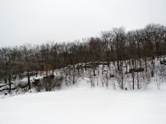 At 11:05 AM we started our hike by crossing the road to start out on the Flynn Trail. After crossing the snow bank left by the plows I was surprised to find a perfect snowshoe trench! Sheila and I continued along the trail with the dog from the cabin following us and his owner still calling him. When we got to the end of the trail through the woods, we turned right on the woods road that was once the extension of Beech Mountain Road. The dog's owner was there to get hold of him and take him home. The track up the Flynn Trail seemed to have a lot of indentations and postholes from bareboots. I couldn't figure out how they got there until I looked back at the gate that separates the private property around the cabin from the state land. There was a large number of boot prints coming up from the parking area. Apparently, the thoughtless people who will not wear snowshoes to reserve the snowshoe track are also those who don't mind trespassing! Of course, the boot prints continued right up the snowshoe track on the Flynn Trail. As we started up the Flynn Trail I tried to fill in the worst postholes but it was difficult since the snow had already frozen solid. There weren't too many deep holes but each smaller indentation caused by snowshoes to twist. It would have been so much nicer to continue on a smooth snowshoe track. In some places there were two snowshoe tracks and both had been chewed up! The overcast skies kept spitting out a combination of snow, sleet and rain but it was all pretty light. I knew I had several options if I needed to cut short my hike. At 1 mile we passed by the open field on the right of the trail. There was no evidence that anybody had visited this area and we kept moving. By 12:10 PM we had hiked the 1.7 miles to the junction with the Big Rock Trail. We continued straight ahead staying on the Flynn Trail heading toward Hodge Pond. I was sorry to see that some snowmobilers who could not read had ignored the "Snowmobiles Prohibited" sign and had used the Flynn Trail. We passed through the gate that marks the OSI property as did the snowmobile tracks. It felt good to walk this flat part of the trail and soon we were at the next trail junction where we continued straight ahead on the Flynn Trail. This section of the trail down to Hodge Pond was the worst with many boot prints that were deeper than on the other trail section. As we approached Hodge Pond, we ran into drifts at least two feet in depth. The barebooters had struggled through these leaving postholes that were more than knee deep. I decided to walk on top of the drifts and had no problem staying there. The snowmobiles had crossed the area by Hodge Pond and continued out the Flynn Trail. We walked over to the shore and found a beautiful sight. All of the trees on the other side of the pond were covered in ice. I took off my pack and got out the camera to try to preserve the scene to show others.
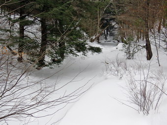 When we were done, I decided we would walk up the jeep trail on the east side of the pond. The snowmobiles had packed the snow which made the walking easier although the hill was steeper than I remembered. We stayed to the left and followed the woods road up the hill and then trued right at the T to get back to the Flynn Trail At the Flynn Trail, we turned left and walked the flat section of the Flynn Trail back to the junction with the Big Rock Trail. The hike can seem long as there are several places that make it seem as if you have reached the bottom of the hill at Times Square. The trail was packed by snowmobiles which made the downhill very enjoyable. I was surprised that we did not hear or see a machine all day. As we walked down the trail Sheila alerted and I heard voices from people walking toward us up the trail. I put Sheila on her leash and we continued until we saw the approaching group of five hikers and their dog. I was surprise for a second time as they were all wearing snowshoes and their dog was on a leash! We stopped to talk briefly. They were from Brooklyn and had rented snowshoes at Morgan Outdoors. I suggested that they take a side trip to Hodge Pond and described the frozen scene. We part continuing in opposite directions. Sheila and I set a quick pace and were at Times Square by 1:35 PM after hiking 4.4 miles. At Times Square we walked straight across to stay on the Big Rock Trail. I had expected there to be a lot of boot prints around the pond but there was a nice snowshoe track instead. I could also see that the group I had met ha come this way. We passed over the bridges over the inlet streams and I noticed that the streams were almost completely covered in snow. I was happy that I had removed the large hemlock that had fallen across the trail as it was much easier to walk through this area without having to hop over the tree. We walked through the beautiful area of pines where there was less snow and then over the wooden walkways covered in snow. At the end of the Big Rock Trail, we turned left on the Quick Lake Trail and walked toward the bridge across the outlet of Frick Pond. At the bridge, I dropped my pack and took out my camera. The scene was interesting as there was a fog or haze hanging over the pond and obscuring Flynn's Point. The area of the out let from the pond was covered in snow as was the outlet stream downstream from the bridge. I took shots of the pond and the stream and some toward the direction of Flynn's Point. I packed up and we walked up the hill to Gravestone Junction. The memorial was covered in snow and the trail was not broken. We followed the Quick Lake Trail and the woods road back to the car. Both of these showed heavy use but there was still a pretty clear track to follow. We were back at the car at 2:15 PM after hiking 5.5 miles in 3 hours and 10 minutes with an elevation gain of 840 feet. The temperature had risen a degree to 29 degrees.
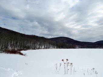
![]()
![]()
![]()
![]()
![]() On Friday, February 12th my back was feeling better even after a snowshoe the day before. It had taken almost a week for me to work out the muscle strain from an incorrect lift on an ambulance call. I felt like taking off on a longer hike with my pack but knew that would not be the smartest choice. I had a tentative plan to go to Clapper Hollow and then over to Stone Store to get two of the winter Scary 19 destinations but the forecast called for highs of 16 degrees which I though was a little cold for Sheila. I asked Cindy if she would like to go snowshoeing at Alder Lake as I knew that would keep me in check. She agreed and we discussed seeing how the track we had set around the lake the previous Friday had faired. When I got up at 6:30 AM, the temperature was 3 degrees and I knew we would be waiting a little while. No new snow had fallen overnight but about 6 inches of snow had fallen in the week since we had been at Alder Lake. We started to get dressed around 11:00 AM. Sheila was underfoot as she was eager to go and did not want us to forget her. I put on my Mammut long-sleeved crew top with a long-sleeved baselayer since the temperature was just cool. I decided to wear my Columbia Titanium insulated pants with a pair of light Mountain Hardwear tights underneath. I wore my Salomon B52 winter boots which are supportive, surprisingly roomy and discontinued. I had recently put a pair of Protalus insoles in these shoes and was anxious to see how they performed. The insoles in most hiking boots are a flimsy and flat piece of material. I also applied a new waterproofing and leather preservative which has proved very effective. I grabbed my Leki external lock poles which I have been using since twist locks have proved unreliable. I also donned my Mammut hoody which was enough zippers to dump heat when needed. I also made sure this time that I put on my OR Crocodile gaiters that I had forgotten to wear last time! I put on a fleecy orange hat for warmth and wore a light pair of gloves. For snowshoes Cindy had her Tubbs Flex VRT which have the Boa binding. This system uses a thin steel cable system and a ratchet wheel which tightens it to give a custom fit and a secure binding. These snowshoes also have a televator to elevate the hiker's heel on ascents. This is a feature that you didn't know you needed until you try it and then it is hard to live without it! I decided to wear my TSL Symbioz snowshoes which have a lot of flex and are good for most terrain except for the steepest ascents on the 35s. They have a ratchet type binding and a televator for steeper climbs. We put our gear in the car and left the house at about 11:15 AM with a very happy Sheila in the backseat. I headed out Old Rt 17 toward Roscoe and turned right or north on the Beaverkill Road to head toward Alder Creek Road. The main roads were only wet but the Beaverkill Road still had a covering of snow and slush. At the intersection with the Barkaboom Road I stayed to the right on Beaverkill Road until we came to the left turn for Alder Creek Road. After turning left, I drove to the end of Alder Creek Road which was plowed wide and had only a little snow on the surface.
On Friday, February 12th my back was feeling better even after a snowshoe the day before. It had taken almost a week for me to work out the muscle strain from an incorrect lift on an ambulance call. I felt like taking off on a longer hike with my pack but knew that would not be the smartest choice. I had a tentative plan to go to Clapper Hollow and then over to Stone Store to get two of the winter Scary 19 destinations but the forecast called for highs of 16 degrees which I though was a little cold for Sheila. I asked Cindy if she would like to go snowshoeing at Alder Lake as I knew that would keep me in check. She agreed and we discussed seeing how the track we had set around the lake the previous Friday had faired. When I got up at 6:30 AM, the temperature was 3 degrees and I knew we would be waiting a little while. No new snow had fallen overnight but about 6 inches of snow had fallen in the week since we had been at Alder Lake. We started to get dressed around 11:00 AM. Sheila was underfoot as she was eager to go and did not want us to forget her. I put on my Mammut long-sleeved crew top with a long-sleeved baselayer since the temperature was just cool. I decided to wear my Columbia Titanium insulated pants with a pair of light Mountain Hardwear tights underneath. I wore my Salomon B52 winter boots which are supportive, surprisingly roomy and discontinued. I had recently put a pair of Protalus insoles in these shoes and was anxious to see how they performed. The insoles in most hiking boots are a flimsy and flat piece of material. I also applied a new waterproofing and leather preservative which has proved very effective. I grabbed my Leki external lock poles which I have been using since twist locks have proved unreliable. I also donned my Mammut hoody which was enough zippers to dump heat when needed. I also made sure this time that I put on my OR Crocodile gaiters that I had forgotten to wear last time! I put on a fleecy orange hat for warmth and wore a light pair of gloves. For snowshoes Cindy had her Tubbs Flex VRT which have the Boa binding. This system uses a thin steel cable system and a ratchet wheel which tightens it to give a custom fit and a secure binding. These snowshoes also have a televator to elevate the hiker's heel on ascents. This is a feature that you didn't know you needed until you try it and then it is hard to live without it! I decided to wear my TSL Symbioz snowshoes which have a lot of flex and are good for most terrain except for the steepest ascents on the 35s. They have a ratchet type binding and a televator for steeper climbs. We put our gear in the car and left the house at about 11:15 AM with a very happy Sheila in the backseat. I headed out Old Rt 17 toward Roscoe and turned right or north on the Beaverkill Road to head toward Alder Creek Road. The main roads were only wet but the Beaverkill Road still had a covering of snow and slush. At the intersection with the Barkaboom Road I stayed to the right on Beaverkill Road until we came to the left turn for Alder Creek Road. After turning left, I drove to the end of Alder Creek Road which was plowed wide and had only a little snow on the surface.
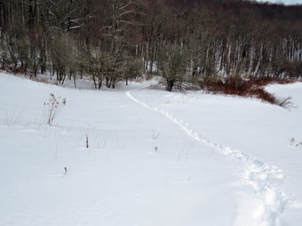 At the end of the road I turned right to pass through the gate to Alder Lake. The gate and parking lot had been closed for the winter but the DEC had agreed to open it. Millbrook Ridge was recently added to the 3500 list as Graham Mountain was closed and the Millbrook Ridge Trail from Alder Lake is a popular way to get there. The access road was plowed wider than the week before and it even looked like some sand had been put down. There was one car in the lot when we parked but a quick survey of the snow indicated that probably two people had left the parking area WITHOUT snowshoes! The temperature was 21 degrees and a slight breeze made it a little cooler. The skies at hoe had been blue with some nice clouds but here they were mostly overcast and dark. I set my GPS and at 11:40 AM we walked over the snow bank left by the plow toward the lake following a faint snowshoe track. We passed by the stone remains of the Coykendall mansion and walked downhill to a point near the shore of the lake. I put down my pack and got out my camera to take a few shots. The skies were completely overcast to the south and east but there was some blue to the north. After taking my pictures, we looked at the tracks and it seemed as if the other hikers had gone along the north shore. I hoped they would only go a short distance and the turn around. I packed up and we started out on the trail along the southern shore of the pond to start our counterclockwise loop. We wanted to go in this direction so we could compare the trail our effort and our time to the previous Friday when we had to break the trail all the way around the lake. The snow was either shallow or frozen across the dam as it was very easy walking. As soon as we stepped off the dam, we began to follow the trail we had made which was barely visible as it had drifted in. It did not seem like many people had been on the trail but those that had been were barebooting. I kept thinking "There's snow, wear snowshoes! The snow off the track varied in depth from a foot to two feet as we walked across the open area and into the woods. As we walked, I kept stopping every few feet to fill in the deepest holes some inconsiderate hiker had made by failing to be prepared to hike in snow. We continued to follow the snowshoe track which we had set and the walking was much easier than a week ago. Cindy doesn't like to break trail and even Sheila was staying behind me. After we crossed the small bridge on the south side of the pond we began to find more drifts that looked more like sand dunes. I remembered how hard it was to negotiate these on the previous hike. This time it was much easier.
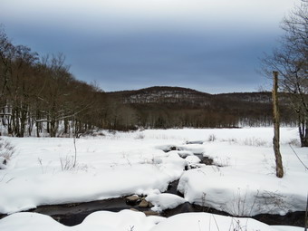 At one point Sheila alerted and I looked up to see a young couple headed toward us without snowshoes. They were sinking in enough to chew up the trail but, since, our track was well set, there were no deep postholes. As they approached, I tried to think of something "educational" to say but the young lady spoke first. She said "You have the idea. We've been doing a lot of hikes without snowshoes but I can see the wisdom in using them." I responded by saying "Yes, it makes it easier for you to walk and preserves the trail for others." We continued in opposite directions with me now filling in the indentations they had made. Fortunately, the trail reaches a high point and the descends some as it approaches the east end of the lake and downhill is always easier. We came to the bridge over Alder Creek and I made sure to stay to the left out of the dry creek bed which is an easier approach. Even the bridge had over a foot of snow and getting up the steps on one side and down them on the other was challenging. We continued to the junction with the Millbrook Ridge Trail. I was surprised that the Millbrook Ridge Trail had not been used at all during the week as there appeared to be at least 4 inches of new snow over a well-defined snowshoe track. I turned right and walked up the trail a short distance and found it to be firm without many holes. I walked back to Cindy at the trail junction and we continued on the trail around the lake. We stopped at one break in the trees so that I could get some shots of the lake facing west. Just before we crossed the bridges across the inlet stream, we stopped so that I could get some more shots. The light seems to be the best I had seen and I took strictures across the lake to Cradle Rock Ridge. We continued along the north shore of the lake there was slightly less snow and where our track was a little better preserved. We broke out of the trees near the "lawn" and we continued to the base of the hill up to the parking area. I decided to cut across the area near the "beach" and join back with the track we had taken on the way. We walked up the hill toward the parking area.
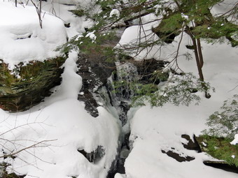 I got the idea that it would be nice to take a look at one of the waterfalls on Alder Creek below the dam. I did my best to convince Cindy that it would be "fun" but she was too smart for that. I mounted the snowbank and headed directly down the steep bank to the creek through 2 to 3 feet of snow. Sheila and I walked parallel to the creek and I stopped to take a few shots of the ice frozen near one of the small rapids. We continued along the creek to the first waterfall. We walked down another steep bank and out onto a rock outcropping that faced the falls. I took off my pack and got out the camera. I took some pictures of the waterfall which was almost completely frozen. I noticed some ducks in the stream and took pictures of them. I could not see Sheila so I called her and she did not come. I looked around and then down toward the stream. I could see her below the rock outcrop I was standing on and called her to come up to me. She tried but could not as she had jumped down and now could not get an traction on the icy rocks. We tried several times to no Vail. I knew that she could walk farther downstream and then up the bank where it was not as steep. I packed up and began walking downstream along the bank calling for her. I looked down the bank and did not see her and was just a little scared until I look behind me and found Sheila following. I was relieved and quickly discussed with her the merits of following my instructions. We started to walk out the woods road toward the pillars. The snow was at least two feet deep and I found a place to cut up to the access road through some very deep snow. Once we were on the access road it was a short walk back to the parking area and the car. We arrived at 1:30 PM after walked 2.1 miles in 1 hour and 45 minutes with 25 minutes of stopped time. The elevation gain was only 210 feet. I was happy to be back but I was already making plans to come back and hike up the Millbrook Ridge Trail.
![]()
![]()
![]()
![]() On Thursday, February 11th I decided to try a short hike on Round Top. I had not hiked for 4 days while trying to rest my back from some painful muscle spasms. I had pulled some muscle on an incorrect lift on an ambulance call and then aggravated the same area on another call. I started to get ready at 11:00 AM when the temperature was 30 degrees. Sheila seemed very happy that we would be going out as we had not been out in 4 days! I knew that the trails would be broken and that I would only have to use snowshoes for traction. I put on my Mammut long-sleeved crew top with a long-sleeved baselayer since the temperature was cool. I decided to wear my Columbia Titanium insulated pants without a baselayer underneath. I wore my Salomon B52 winter boots which are supportive, surprisingly roomy and discontinued. I had recently put a pair of Protalus insoles in these shoes and was anxious to see how they performed. The insoles in most hiking boots are a flimsy and flat piece of material. I did not expect much snow although the possibility of mud was on my mind. I grabbed my Leki external lock poles which I have been using since the spring since twist locks have proved unreliable. I also donned my Mammut hoody which was enough zippers to dump heat when needed. I put on a fleecy orange hat and wore a light pair of gloves. I also put on my OR Crocodile gaiters which some almost to my knee to deal with the snow and to keep my lower legs warm. I decided to wear my TSL Symbioz snowshoes which have a lot of flex and are good for most terrain except for the steepest ascents on the 35s. They have a ratchet type binding and a televator for steeper climbs. Sheila kept Bryce and I in sight as I got ready to go making sure she would not be forgotten. We stepped out of the house at 11:20 AM. I grabbed Sheila's leash from the car and put it on her to safely cross the street. We walked up the driveway and crossed the street. We mounted the snow bank left by the plow with some difficulty and headed across the field by the church. There was a stiff breeze blowing that I knew would disappear once we got on the trails. As we started up the hill, I realized that there was a lot of snow and I was glad Cindy and I had broken the trail he previous week! We began the ascent of the steepest hill behind the church. The hill is short but gets the circulation pumping and is the steepest and longest climb on the "trail." I let Sheila off her leash so that I could use my poles to get up the hill. Sheila immediately began to bound up the hill as I followed. The cemetery was covered in snow and all the trees on the surrounding hills were snow clad. When we got to the top of the hill, we stopped to look around at the hills around town. We started on the trail by turning left at the trailhead. There were no tracks on the trails.
On Thursday, February 11th I decided to try a short hike on Round Top. I had not hiked for 4 days while trying to rest my back from some painful muscle spasms. I had pulled some muscle on an incorrect lift on an ambulance call and then aggravated the same area on another call. I started to get ready at 11:00 AM when the temperature was 30 degrees. Sheila seemed very happy that we would be going out as we had not been out in 4 days! I knew that the trails would be broken and that I would only have to use snowshoes for traction. I put on my Mammut long-sleeved crew top with a long-sleeved baselayer since the temperature was cool. I decided to wear my Columbia Titanium insulated pants without a baselayer underneath. I wore my Salomon B52 winter boots which are supportive, surprisingly roomy and discontinued. I had recently put a pair of Protalus insoles in these shoes and was anxious to see how they performed. The insoles in most hiking boots are a flimsy and flat piece of material. I did not expect much snow although the possibility of mud was on my mind. I grabbed my Leki external lock poles which I have been using since the spring since twist locks have proved unreliable. I also donned my Mammut hoody which was enough zippers to dump heat when needed. I put on a fleecy orange hat and wore a light pair of gloves. I also put on my OR Crocodile gaiters which some almost to my knee to deal with the snow and to keep my lower legs warm. I decided to wear my TSL Symbioz snowshoes which have a lot of flex and are good for most terrain except for the steepest ascents on the 35s. They have a ratchet type binding and a televator for steeper climbs. Sheila kept Bryce and I in sight as I got ready to go making sure she would not be forgotten. We stepped out of the house at 11:20 AM. I grabbed Sheila's leash from the car and put it on her to safely cross the street. We walked up the driveway and crossed the street. We mounted the snow bank left by the plow with some difficulty and headed across the field by the church. There was a stiff breeze blowing that I knew would disappear once we got on the trails. As we started up the hill, I realized that there was a lot of snow and I was glad Cindy and I had broken the trail he previous week! We began the ascent of the steepest hill behind the church. The hill is short but gets the circulation pumping and is the steepest and longest climb on the "trail." I let Sheila off her leash so that I could use my poles to get up the hill. Sheila immediately began to bound up the hill as I followed. The cemetery was covered in snow and all the trees on the surrounding hills were snow clad. When we got to the top of the hill, we stopped to look around at the hills around town. We started on the trail by turning left at the trailhead. There were no tracks on the trails.
At the first trail junction, we followed Sheila as she continued up the hill toward the lookout. Walking up the hill was not too difficult and my back felt OK. At the top of the hill we followed the snowshoe track and the yellow markers as they turned right. The trail begins a gentle uphill and the walking was easy except for one short, steep section where I had to be sure my snowshoe crampon bit into the snow. At the junction with the upper blue trail we turned right and followed the yellow trails along the base of Round Top. The next time we met the blue trail we turned left and started up toward the summit. I was really feeling fresh and we seemed be going at a pretty fast pace as we passed the white crossover trail. Once we got to the summit we walked across it and started down the other side. This is the steepest part of the trail which is why I added a switchback. I decided to avoid both the crossover trail and the switchback and simply head straight for the bottom. I sued my poles for balance and picked up the tips of my snowshoes for a quick descent to the trail junction. We turned left on the trail and again followed it to the junction with the blue trail. I usually turn right to complete a figure eight but this time we turned left and again headed for the summit. As we ascended, we turned left on the white crossover trail and followed it back to the main blue trail on the other side of the hill. We turned left and almost immediately left again on the switchback. We followed the switchback to the main blue trail again and turned left to descend to the trail junction. One more time we turned left on the yellow trail and followed it to the junction with the blue trail. We trued right to stay on the yellow trail and walked down the woods road to the first trail junction. We turned left and walked out to the trail head and down the hill to the church. We walked across the field to the road. Sheila waited until Is aid "Cross!" And then she headed for our driveway. We walked down the driveway and were back home at 12:30 POM taking a little over and hour to cover a little less than2 miles.
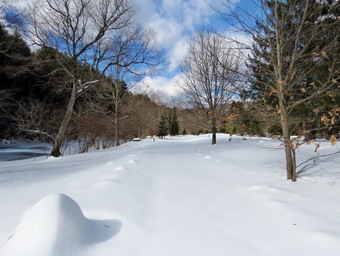
![]()
![]()
![]()
![]()
![]() On Saturday, February 6th, I had decided to take off from hiking as I had tweaked my back on several ambulance calls. I had ignored the discomfort and hiked the day before which proved not to be a good idea. I got up late trying to in catch up on some sleep I had missed from late night ambulance calls. At 9:00 AM the temperature was 33 degrees on the back porch and the sun was shining with some wispy white clouds. I knew I could not resists these conditions so I planned too take a short snowshoe somewhere. I thought about going back to Alder Lake and hiking clockwise around the lake or out the Millbrook Ridge Trail. I instead decided to go to the Beaverkill Campgrounds and hike along the river. I started to get ready at 10:15 AM with the temperature at 33 degrees under sunny skies. I put on my Mammut long-sleeved crew top with a long-sleeved baselayer since the temperature was just cool. I decided to wear my Columbia Titanium insulated pants with a pair of light Mountain Hardwear tights underneath. I wore my Salomon B52 winter boots which are supportive, surprisingly roomy and discontinued. I had recently put a pair of Protalus insoles in these shoes and was anxious to see how they performed. The insoles in most hiking boots are a flimsy and flat piece of material. I also applied a new waterproofing and leather preservative which has proved very effective. I grabbed my Leki external lock poles which I have been using since the spring since twist locks have proved unreliable. I also donned my Mammut hoody which was enough zippers to dump heat when needed. I put on a fleecy orange hat for warmth and wore a light pair of gloves. I decided to wear my TSL Symbioz snowshoes which have a lot of flex and are good for most terrain except for the steepest ascents on the 35s. They have a ratchet type binding and a televator for steeper climbs. I put my gear in the car and left the house at 11:30 AM with a very happy Sheila in the backseat. I headed out Old Rt 17 toward Roscoe and turned right or north on the Beaverkill Road to head toward Lew Beach. As we started the descent into the Beaverkill Valley, I turned left on Campsite Road and followed it down to the parking area near the Beaverkill Covered Bridge.
On Saturday, February 6th, I had decided to take off from hiking as I had tweaked my back on several ambulance calls. I had ignored the discomfort and hiked the day before which proved not to be a good idea. I got up late trying to in catch up on some sleep I had missed from late night ambulance calls. At 9:00 AM the temperature was 33 degrees on the back porch and the sun was shining with some wispy white clouds. I knew I could not resists these conditions so I planned too take a short snowshoe somewhere. I thought about going back to Alder Lake and hiking clockwise around the lake or out the Millbrook Ridge Trail. I instead decided to go to the Beaverkill Campgrounds and hike along the river. I started to get ready at 10:15 AM with the temperature at 33 degrees under sunny skies. I put on my Mammut long-sleeved crew top with a long-sleeved baselayer since the temperature was just cool. I decided to wear my Columbia Titanium insulated pants with a pair of light Mountain Hardwear tights underneath. I wore my Salomon B52 winter boots which are supportive, surprisingly roomy and discontinued. I had recently put a pair of Protalus insoles in these shoes and was anxious to see how they performed. The insoles in most hiking boots are a flimsy and flat piece of material. I also applied a new waterproofing and leather preservative which has proved very effective. I grabbed my Leki external lock poles which I have been using since the spring since twist locks have proved unreliable. I also donned my Mammut hoody which was enough zippers to dump heat when needed. I put on a fleecy orange hat for warmth and wore a light pair of gloves. I decided to wear my TSL Symbioz snowshoes which have a lot of flex and are good for most terrain except for the steepest ascents on the 35s. They have a ratchet type binding and a televator for steeper climbs. I put my gear in the car and left the house at 11:30 AM with a very happy Sheila in the backseat. I headed out Old Rt 17 toward Roscoe and turned right or north on the Beaverkill Road to head toward Lew Beach. As we started the descent into the Beaverkill Valley, I turned left on Campsite Road and followed it down to the parking area near the Beaverkill Covered Bridge.
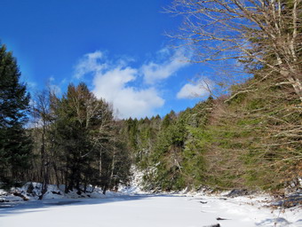 As I parked, there were no other cars in the lot which was a sharp departure from the crowds this summer. The river was higher than I thought it might be with part of it flowing and another part frozen. As I was getting ready, a car pulled into the lot and two young women in stylish boots got out. They tried to walk over to the bridge but their boots kept slipping on the ice. I set my GPS and we started our hike at 10:55 AM by crossing the bridge to the west side of the river. I carried my snowshoes as I did not ant to wear them on the road or bridge. As we exited the bridge, we turned left and I stopped to put on the snowshoes. The woods road that parallels the river had only a few inches of snow and I knew this would be easier on my back that breaking trail in deeper snow. There were two sets of old boot prints in the snow and I followed them to try to create a track. We walked past a spring house and continued on the deserted woods road. The snow began to get deeper and was about 6 to 10 inches which I could feel in my back. We came to an area with a little path down to the river. I walked down to the edge of the river and took some pictures downstream and some upstream which included the bridge. Soon we came to a picnic table surrounded by snow with snow piled on top of it. I decided to take pictures that showed the deserted campgrounds which was even more dramatic now that the snow was piled round. I took pictures of the picnic tables and, a little later, what was once a bathroom for some campsites that had long since disappeared. At the next bathroom we stopped so that I could take some more pictures. I walked to the edge of the river and took some pictures of the sun reflecting off the water. In several areas the DEC had placed large rocks along the shore and covered them with heavy wire to reduce erosion. Before leaving I also took pictures of the deteriorating bathrooms. At about .7 miles the woods road met the paved road that serves the campsites. I had almost decided to turn around here but it did not seem like an appropriate place to end.
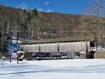 It looked like the DEC had plowed once before the big storm but there was plenty of snow left. We continued our hike on the unplowed road along the river. Many of the campsites had a cement block fireplace with a grill but some were upgraded to poured concrete. Everything was very quiet except for the water in the river as it ran beneath the ice on the surface of the river. This was not surprising as the campsites are closed. I took some pictures of all the empty campsites. Even though the hike is almost flat I was feeling every step in my back. We walked to the last campsite where the trail ends and I walked down to the river to take some pictures of the ice on top of the flowing water. I also took pictures downstream which caught the blue sky with clouds. We turned around to start back and I decided to walk back in the same track we had come out on. This was the best way to set a good track. Walking back was easier as the track was broken but I was trying to walk so that I packed down the part of the track I had missed on the way out. I did notice that my stride length on the way back was shorter than on the way out! I did not stop to take any pictures so things did go a little faster. We came to the last uphill to the road and it was easier than I thought it would be. I decided to take off my snowshoes before crossing the bridge. I found that it was easier to sit on the top bar of the gate to get the shoes off. I picked up the snowshoes and we walked across the bridge to the car. I was about to take some pictures of the bridge when another car pulled in. This car had a dog in it and the owner did not have a leash. I have grown used to inconsiderate dog owners so I put Sheila in the car. I took my camera and walked over to take a few shots of the bridge and the returned to the car. It was 12:50 PM and we had hiked 2.2 miles in 2 hours with an elevation gain of 190 feet.
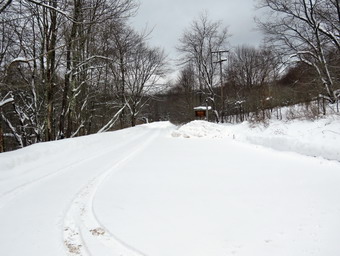
![]()
![]()
![]()
![]()
![]() On Friday, February 5th I wanted to go somewhere away from home to snowshoe in some unbroken snow. I asked Cindy if she wanted to go knowing here two primary criteria were "short and flat". When I suggested a hike around Alder Lake, she agreed. We both thought this would be an easy hike. When I got up, the temperature was 30 degrees and about two inches of new snow had fallen overnight. I knew that the temperature would be going up slightly but that it might be cooler at the trailhead. The forecast called for some wind which I knew would make the temperature feel lower. We started to get dressed around 10:45 AM. Sheila was underfoot as she was eager to go and did not want us to forget her. I put on my Mammut long-sleeved crew top with a long-sleeved baselayer since the temperature was just cool. I decided to wear my Columbia Titanium insulated pants with a pair of light Mountain Hardwear tights underneath. I wore my Salomon B52 winter boots which are supportive, surprisingly roomy and discontinued. I had recently put a pair of Protalus insoles in these shoes and was anxious to see how they performed. The insoles in most hiking boots are a flimsy and flat piece of material. I also applied a new waterproofing and leather preservative which has proved very effective. I grabbed my Leki external lock poles which I have been using since the spring since twist locks have proved unreliable. I also donned my Mammut hoody which was enough zippers to dump heat when needed. I put on a fleecy orange hat for warmth and wore a light pair of gloves. For snowshoes Cindy had her Tubbs Flex VRT which have the Boa binding. This system uses a thin steel cable system and a ratchet wheel which tightens it to give a custom fit and a secure binding. These snowshoes also have a televator to elevate the hiker's heel on ascents. This is a feature that you didn't know you needed until you try it and then it is hard to live without it! I decided to wear my TSL Symbioz snowshoes which have a lot of flex and are good for most terrain except for the steepest ascents on the 35s. They have a ratchet type binding and a televator for steeper climbs. We put our gear in the car and left the house at about 11:15 AM with a very happy Sheila in the backseat. I headed out Old Rt 17 toward Roscoe and turned right or north on the Beaverkill Road to head toward Alder Creek Road. The main roads were only wet but the Beaverkill Road still had a covering of snow and slush. At the intersection with the Barkaboom Road I stayed to the right on Beaverkill Road until we came to the left turn for Alder Creek Road. After turning left, I drove to the end of Alder Creek Road which was plowed wide and had only a little snow on the surface.
On Friday, February 5th I wanted to go somewhere away from home to snowshoe in some unbroken snow. I asked Cindy if she wanted to go knowing here two primary criteria were "short and flat". When I suggested a hike around Alder Lake, she agreed. We both thought this would be an easy hike. When I got up, the temperature was 30 degrees and about two inches of new snow had fallen overnight. I knew that the temperature would be going up slightly but that it might be cooler at the trailhead. The forecast called for some wind which I knew would make the temperature feel lower. We started to get dressed around 10:45 AM. Sheila was underfoot as she was eager to go and did not want us to forget her. I put on my Mammut long-sleeved crew top with a long-sleeved baselayer since the temperature was just cool. I decided to wear my Columbia Titanium insulated pants with a pair of light Mountain Hardwear tights underneath. I wore my Salomon B52 winter boots which are supportive, surprisingly roomy and discontinued. I had recently put a pair of Protalus insoles in these shoes and was anxious to see how they performed. The insoles in most hiking boots are a flimsy and flat piece of material. I also applied a new waterproofing and leather preservative which has proved very effective. I grabbed my Leki external lock poles which I have been using since the spring since twist locks have proved unreliable. I also donned my Mammut hoody which was enough zippers to dump heat when needed. I put on a fleecy orange hat for warmth and wore a light pair of gloves. For snowshoes Cindy had her Tubbs Flex VRT which have the Boa binding. This system uses a thin steel cable system and a ratchet wheel which tightens it to give a custom fit and a secure binding. These snowshoes also have a televator to elevate the hiker's heel on ascents. This is a feature that you didn't know you needed until you try it and then it is hard to live without it! I decided to wear my TSL Symbioz snowshoes which have a lot of flex and are good for most terrain except for the steepest ascents on the 35s. They have a ratchet type binding and a televator for steeper climbs. We put our gear in the car and left the house at about 11:15 AM with a very happy Sheila in the backseat. I headed out Old Rt 17 toward Roscoe and turned right or north on the Beaverkill Road to head toward Alder Creek Road. The main roads were only wet but the Beaverkill Road still had a covering of snow and slush. At the intersection with the Barkaboom Road I stayed to the right on Beaverkill Road until we came to the left turn for Alder Creek Road. After turning left, I drove to the end of Alder Creek Road which was plowed wide and had only a little snow on the surface.
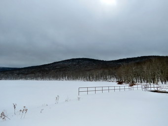 At the end of the road I turned right to pass through the gate to Alder Lake. The gate and parking lot had been closed for the winter but the DEC had agreed to open it. Millbrook Ridge was recently added to the 3500 list as Graham Mountain was closed and the Millbrook Ridge Trail from Alder Lake is a popular way to get there. The access road was a little slippery but the parking lot was completely plowed. We were both happy to be the only car in the lot and a quick survey of the snow indicated that at most two people had been there since the major storm at the beginning of the week. The temperature was 33 degrees and a slight breeze made it a little cooler. The skies were mostly overcast and as we looked past the head end of the lake it looked like it might still be snowing on Balsam Lake Mountain. I set my GPS and we walked over the snow bank left by the plow toward the lake following a faint snowshoe track. We passed by the stone remains of the Coykendall mansion and walked downhill to a point near the shore of the lake. I put down my pack and got out my camera to take a few shots. The skies were completely overcast and a mist or fog hung over some of the surrounding hills. After taking my pictures, I packed up and we started out on the trail along the southern shore of the pond to start our counterclockwise loop. I had no reasons for going in this direction other than the fact that we usually go the other way. The snow was either shallow or frozen across the dam as it was very easy walking. As soon as we stepped off the dam, we began to sink into the snow and the work we would have to do became clear. The snow varied in depth from a foot to two feet as we walked across the open area and into the woods. We continued to follow the snowshoe track which split several times leading me to believe there may have been two people. Not very far along the trail the track started off to the right of the trail and then crossed the trail and headed down to the shore of the lake. We never saw any evidence of that trail or nay other and we were on our won. Cindy doesn't like to break trail and even Sheila was staying behind me. It was difficult keeping a fast pace but I have realized as I get older it is more about finishing than finishing quickly. After we crossed the small bridge on the south side of the pond we began to find more drifts that looked more like sand dunes. I tried walking on the lee side of them but finally decided to go up on top of the dunes. The drifted snow was so consolidate that I could walk on top and only sink a few inches in most places.
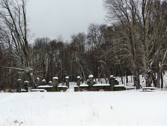 Fortunately, the trail reaches a high point and the descends some as it approaches the east end of the lake. We came to the bridge over Alder Creek and I realized we were walking in part of the stream bed which carries water when the creek overflows. The side were steep so Cindy walked back a short distance on the trail while Sheila and I tried to scale the bank. At one point Sheila was moving her legs very fast but going nowhere. She eventually caught hold and made it up the bank. I learned from what she had done and dug the crampon on my snowshoe into the bank and used my poles to boost myself up. Even the bridge had over a foot of snow and getting up the steps on one side and won them on the other was challenging. We continued past the junction with the Millbrook Ridge Trail. I noticed someone had put up a hand-lettered sign and wondered why people believe they are allowed to do this. The official sign on the other side of the trail gave much the same information. We continued on the trail around the lake stopping at one break in the trees so that I could get some shots of the lake facing west. As I packed up, I thought I saw Sheila shivering a little and resolved to pick up the pace. Usually Sheila simply runs around a little to get warm but it was difficult with all the snow. We crossed both of the bridges across the inlet stream and started along the north shore of the lake. I had hoped that the snow depth would be less on this side of the lake but that was not the case. I tried to keep a faster pace and did for the most part. As we broke out of the trees and neared the "lawn", the sun came out briefly and we stopped so that I could take a few pictures. From that point we continued to the base of the hill up to the parking area. I decided to cut across the area near the "beach" and join back with the track we had taken on the way. We walked up that and back to the car. We arrived at 1:50 Pm after walked 1.8 miles in 2 hours and 5 minutes with 30 minutes of stopped time. The elevation gain was only 150 feet. I was happy to be back but I was already making plans to come back and hike up the Millbrook Ridge Trail. Driving out the access road went better than I had thought but winter tires and all-wheel drive certainly help.
![]()
![]()
![]()
![]() On Wednesday, February 3rd I had agreed to hike with Lisa on Round Top at 11:30 AM. I knew my grandson Bryce would be at the house and would like to go along. I did two ambulance calls overnight and was feeling both tired and exhausted by the time 9:00 AM rolled around. We have responded to more than 1 call a day on the average for this year which is far above our average volume. I though about calling Lisa and backing out but knew I would feel better and that the hike would be relatively short. I have wanted to get out for a longer hike but the recent massive snowstorm makes breaking trail solo difficulty and many of the parking lots a re still unplowed. We started to get ready at 11:00 AM when the temperature was 30 degrees. Sheila seemed very happy that we would be going out even though we had snowshoed the day before. I brought Bryce's MSR Tykers up from the basement. They are really too small for him but the adult shoes I have are just a little large. I knew that the trails would be broken and that he would only use them for traction. I put on my Mammut long-sleeved crew top with a long-sleeved baselayer since the temperature was cool. I decided to wear my Columbia Titanium insulated pants without a baselayer underneath. I wore my Salomon B52 winter boots which are supportive, surprisingly roomy and discontinued. I had recently put a pair of Protalus insoles in these shoes and was anxious to see how they performed. The insoles in most hiking boots are a flimsy and flat piece of material. I did not expect much snow although the possibility of mud was on my mind. I grabbed my Leki external lock poles which I have been using since the spring since twist locks have proved unreliable. I also donned my Mammut hoody which was enough zippers to dump heat when needed. I put on a fleecy orange hat and wore a light pair of gloves. I also put on my OR Crocodile gaiters which some almost to my knee to deal with the snow and to keep my lower legs warm. I decided to wear my TSL Symbioz snowshoes which have a lot of flex and are good for most terrain except for the steepest ascents on the 35s. They have a ratchet type binding and a televator for steeper climbs. Sheila kept Bryce and I in sight as I got ready to go making sure she would not be forgotten. We stepped out of the house at 11:20 AM. I grabbed Sheila's leash from the car and put it on her to safely cross the street. We walked up the driveway and crossed the street. We mounted the snow bank left by the plow with some difficulty and headed across the field by the church. As we started across the field, we could see Lisa parked by the church getting ready to hike. When Sheila saw her, she began to pull toward her. Sheila can be cautious around people but once you are part of her "pack" you are good forever. Sheila said "Hello" to Lisa and we waited for her to be ready before to the hill that ascends to the trailhead. There was a stiff breeze blowing that I knew would disappear once we got on the trails. As we started up the hill, I realized that there was a lot of snow and I was glad Cindy and I had broken the trail the day before! We began the ascent of the steepest hill behind the church. The hill is short but gets the circulation pumping and is the steepest and longest climb on the "trail." I let Sheila off her leash so that I could use my poles to get up the hill. Sheila immediately began to bound up the hill as we followed. The cemetery was covered in snow and all the trees on the surrounding hills were snow clad. When we got to the top of the hill, we stopped to look around at the hills around town. We started on the trail by turning left at the trailhead. The only tracks on the trails were the ones Cindy and I had made the day before.
On Wednesday, February 3rd I had agreed to hike with Lisa on Round Top at 11:30 AM. I knew my grandson Bryce would be at the house and would like to go along. I did two ambulance calls overnight and was feeling both tired and exhausted by the time 9:00 AM rolled around. We have responded to more than 1 call a day on the average for this year which is far above our average volume. I though about calling Lisa and backing out but knew I would feel better and that the hike would be relatively short. I have wanted to get out for a longer hike but the recent massive snowstorm makes breaking trail solo difficulty and many of the parking lots a re still unplowed. We started to get ready at 11:00 AM when the temperature was 30 degrees. Sheila seemed very happy that we would be going out even though we had snowshoed the day before. I brought Bryce's MSR Tykers up from the basement. They are really too small for him but the adult shoes I have are just a little large. I knew that the trails would be broken and that he would only use them for traction. I put on my Mammut long-sleeved crew top with a long-sleeved baselayer since the temperature was cool. I decided to wear my Columbia Titanium insulated pants without a baselayer underneath. I wore my Salomon B52 winter boots which are supportive, surprisingly roomy and discontinued. I had recently put a pair of Protalus insoles in these shoes and was anxious to see how they performed. The insoles in most hiking boots are a flimsy and flat piece of material. I did not expect much snow although the possibility of mud was on my mind. I grabbed my Leki external lock poles which I have been using since the spring since twist locks have proved unreliable. I also donned my Mammut hoody which was enough zippers to dump heat when needed. I put on a fleecy orange hat and wore a light pair of gloves. I also put on my OR Crocodile gaiters which some almost to my knee to deal with the snow and to keep my lower legs warm. I decided to wear my TSL Symbioz snowshoes which have a lot of flex and are good for most terrain except for the steepest ascents on the 35s. They have a ratchet type binding and a televator for steeper climbs. Sheila kept Bryce and I in sight as I got ready to go making sure she would not be forgotten. We stepped out of the house at 11:20 AM. I grabbed Sheila's leash from the car and put it on her to safely cross the street. We walked up the driveway and crossed the street. We mounted the snow bank left by the plow with some difficulty and headed across the field by the church. As we started across the field, we could see Lisa parked by the church getting ready to hike. When Sheila saw her, she began to pull toward her. Sheila can be cautious around people but once you are part of her "pack" you are good forever. Sheila said "Hello" to Lisa and we waited for her to be ready before to the hill that ascends to the trailhead. There was a stiff breeze blowing that I knew would disappear once we got on the trails. As we started up the hill, I realized that there was a lot of snow and I was glad Cindy and I had broken the trail the day before! We began the ascent of the steepest hill behind the church. The hill is short but gets the circulation pumping and is the steepest and longest climb on the "trail." I let Sheila off her leash so that I could use my poles to get up the hill. Sheila immediately began to bound up the hill as we followed. The cemetery was covered in snow and all the trees on the surrounding hills were snow clad. When we got to the top of the hill, we stopped to look around at the hills around town. We started on the trail by turning left at the trailhead. The only tracks on the trails were the ones Cindy and I had made the day before.
At the first trail junction, we followed Sheila as she turned right on the woods road which is the shallower approach to the trail system. We followed the snowshoe track that Cindy and I had set the day before which made the walking much easier. Bryce was doing fine with his snowshoes and poles and Sheila was making her own way sticking her head under the snow at every opportunity. We continued to follow the yellow trail toward the first junction. At the junction, we turned left and followed the track to the next trail junction. Some of the snow on the trees had fallen off with the wind but the scene was still beautiful. At the second junction with the blue trail, we turned right and started up the steep blue trail that leads over the summit of Round Top. Just before the steepest section we turned right on the switchback trail marked with blue paint blazes. This trail was not broken which made the hiking a little more difficult. We continued to follow these blazes as they made a sharp left turn and headed back to the main blue trail. We turned right on the blue trail and continued up the blue trail. Within a few feet, we turned right on the white crossover trail which also was not broken out. Breaking trail through the snow was actually fun and we followed the trail to the end where it intersected the blue trail on the other side of Round Top. I decided to take a slightly different route so we turned left and started up the hill to the summit of Round Top. Even though the trail was broken, going uphill was a little more strenuous. We crossed over the summit and got ready to descend the steeper side of the hill. I started down keeping my weight on my heels and kept my balance as I quickly descended. Once I was passed the rock in the trail, I began taking longer strides which increased my speed. Bryce slipped a little on the way down but was soon with me followed by Lisa. We turned left on the yellow trail which now had well-packed track. At the next junction with the blue trail, we turned left and started up toward the summit. When we reached the white crossover trail, we turned left and followed it over to the main blue trail on the other side of the summit. We turned left and then left again on the switchback to help pack the trail we had broken earlier. At the end of the switchback we turned left and walked down to the trail junction. This time we continued straight ahead on the yellow trail headed for the lookout. Going downhill on gently sloping broken trail seemed so easy. We stopped at the lookout and Lisa took some pictures of us at the viewpoint. We started down the yellow trail to the first trail junction. We continued out to the trailhead where we turned right and headed down the hill. We walked behind the church and said "Goodbye" to Lisa at her car. When we started across the field to our driveway, I noticed that the track we had set earlier was almost completely drifted in. We walked across the field to our driveway. We were back at the house at 1:15 PM having walked a little over 2 miles in an hour and 45 minutes.
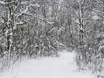
![]()
![]()
![]()
![]()
![]() On Tuesday, February 2nd a snowstorm during the day on Monday continued overnight dropping 15 inches of snow on downtown Livingston Manor. As is often the case, there had been several ambulance calls in the middle of the storm. On Monday I was ready to step out the door and the pager went off. I had a lot of explaining to do to Sheila when I got back home. An early call on Tuesday brought me back home at 7:30 AM. I decided it would better to take a hike before settling down to get a nap. The wind was starting to blow and I wanted to get some pictures of the snow on the trees. I did not want to drive anywhere as the roads to hiking areas and the parking areas would not be plowed. I decided to go across the street and hike on Round Top. I asked Cindy if she wanted to go and she agreed. We started getting ready at 8:30 AM when the temperature was a warm 30 degrees with overcast skies and some light snow still hanging around. I got dressed in my Mammut crew top with a light baselayer underneath. I put on my Mammut long-sleeved crew top with a long-sleeved baselayer since the temperature was just cool. I decided to wear my Columbia Titanium insulated pants without tights underneath. I wore my Salomon B52 winter boots which are supportive, surprisingly roomy and discontinued. I had recently put a pair of Protalus insoles in these shoes and was anxious to see how they performed. The insoles in most hiking boots are a flimsy and flat piece of material. I also applied a new waterproofing and leather preservative which has proved very effective. I grabbed my Leki external lock poles which I have been using since the spring since twist locks have proved unreliable. I also donned my Mammut hoody which was enough zippers to dump heat when needed. I put on a fleecy orange hat for warmth and wore a light pair of gloves. I also put on my OR Crocodile gaiters which some almost to my knee to deal with the snow and to keep my lower legs warm. Cindy and I decided to wear snowshoes which was the main reason we were going out! Cindy had her Tubbs Flex VRT which have the Boa binding. This system uses a thin steel cable system and a ratchet wheel which tightens it to give a custom fit and a secure binding. These snowshoes also have a televator to elevate the hiker's heel on ascents. This is a feature that you didn't know you needed until you try it and then it is hard to live without it! I decided to wear my TSL Symbioz snowshoes which have a lot of flex and are good for most terrain except for the steepest ascents on the 35s. They have a ratchet type binding and a televator for steeper climbs. Sheila kept us both in sight as I got ready to go making sure she would not be forgotten. I took my pack with me as it is the easiest way to carry my camera. We stepped out of the house at 9:10 PM. I grabbed Sheila's leash from the car and put it on her to safely cross the street. We walked up the driveway and crossed the street. We mounted the snow bank left by the plow with some difficulty and headed across the field by the church to the hill that ascends to the trailhead. As we started up the hill, I realized that there was a lot of snow! We began the ascent of the steepest hill behind the church. The hill is short but gets the circulation pumping and is the steepest and longest climb on the "trail." I let Sheila off her leash so that I could use my poles to get up the hill. Sheila immediately began to bound up the hill with Cindy and I following close behind. The going was more difficult than I had expected and I had to pause a few times. We stopped in the middle of the hill so that I could take pictures toward the "Flats" to the southeast. The cemetery was covered in snow and all the trees on the surrounding hills were snow clad. When we got to the top of the hill, we stopped to look around at the hills around town. I took some more pictures across the valley to "Beer Mountain" and some to the north and west. We started on the trail by turning left at the trailhead. There were no tracks on the trails as we were the first ones out to hike.
On Tuesday, February 2nd a snowstorm during the day on Monday continued overnight dropping 15 inches of snow on downtown Livingston Manor. As is often the case, there had been several ambulance calls in the middle of the storm. On Monday I was ready to step out the door and the pager went off. I had a lot of explaining to do to Sheila when I got back home. An early call on Tuesday brought me back home at 7:30 AM. I decided it would better to take a hike before settling down to get a nap. The wind was starting to blow and I wanted to get some pictures of the snow on the trees. I did not want to drive anywhere as the roads to hiking areas and the parking areas would not be plowed. I decided to go across the street and hike on Round Top. I asked Cindy if she wanted to go and she agreed. We started getting ready at 8:30 AM when the temperature was a warm 30 degrees with overcast skies and some light snow still hanging around. I got dressed in my Mammut crew top with a light baselayer underneath. I put on my Mammut long-sleeved crew top with a long-sleeved baselayer since the temperature was just cool. I decided to wear my Columbia Titanium insulated pants without tights underneath. I wore my Salomon B52 winter boots which are supportive, surprisingly roomy and discontinued. I had recently put a pair of Protalus insoles in these shoes and was anxious to see how they performed. The insoles in most hiking boots are a flimsy and flat piece of material. I also applied a new waterproofing and leather preservative which has proved very effective. I grabbed my Leki external lock poles which I have been using since the spring since twist locks have proved unreliable. I also donned my Mammut hoody which was enough zippers to dump heat when needed. I put on a fleecy orange hat for warmth and wore a light pair of gloves. I also put on my OR Crocodile gaiters which some almost to my knee to deal with the snow and to keep my lower legs warm. Cindy and I decided to wear snowshoes which was the main reason we were going out! Cindy had her Tubbs Flex VRT which have the Boa binding. This system uses a thin steel cable system and a ratchet wheel which tightens it to give a custom fit and a secure binding. These snowshoes also have a televator to elevate the hiker's heel on ascents. This is a feature that you didn't know you needed until you try it and then it is hard to live without it! I decided to wear my TSL Symbioz snowshoes which have a lot of flex and are good for most terrain except for the steepest ascents on the 35s. They have a ratchet type binding and a televator for steeper climbs. Sheila kept us both in sight as I got ready to go making sure she would not be forgotten. I took my pack with me as it is the easiest way to carry my camera. We stepped out of the house at 9:10 PM. I grabbed Sheila's leash from the car and put it on her to safely cross the street. We walked up the driveway and crossed the street. We mounted the snow bank left by the plow with some difficulty and headed across the field by the church to the hill that ascends to the trailhead. As we started up the hill, I realized that there was a lot of snow! We began the ascent of the steepest hill behind the church. The hill is short but gets the circulation pumping and is the steepest and longest climb on the "trail." I let Sheila off her leash so that I could use my poles to get up the hill. Sheila immediately began to bound up the hill with Cindy and I following close behind. The going was more difficult than I had expected and I had to pause a few times. We stopped in the middle of the hill so that I could take pictures toward the "Flats" to the southeast. The cemetery was covered in snow and all the trees on the surrounding hills were snow clad. When we got to the top of the hill, we stopped to look around at the hills around town. I took some more pictures across the valley to "Beer Mountain" and some to the north and west. We started on the trail by turning left at the trailhead. There were no tracks on the trails as we were the first ones out to hike.
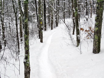 At the first trail junction, we continued straight ahead up the hill toward the viewpoint. Again, the climb up the hill was pretty tiring especially since I only had Sheila to break trail ahead of me with Cindy following. At the viewpoint, Sheila and I headed to the left and walked out to the overhanging rock shelf that forms the lookout. Cindy decided to continue on the trail to the upper part of the lookout. Even though it was still snowing, I took pictures of town and the school. I also took some shots of the hills around town. Cindy took some shots from where she was including a nice one of Sheila sitting in the snow. Shiela bounded up from the lower lookout to where Cindy was standing and I followed somewhat more slowly. We walked to the main trail and followed the yellow trail as it turned right and headed up the gentle hill through the hardwood forest with trees encased in snow. There was no wind and everything was very still. At the first trail junction with the blue trail we stopped so that I could take some pictures of the pristine trails along the base of Round Top. The bushes and trees were laden with snow which made a beautiful sight. We turned right and followed the yellow trail along the base of Round Top. This section was easier, even though the snow was a little deeper, as it was flat. At the next junction, we turned left and started up to the summit of Round Top on the blue trail. Cindy and I both felt the elevation gain as we hiked ho the hill. Sheila was unaffected. We bypassed the white crossover trail and continued up and over the summit. When we started down the other side, I decided we would skip the new switchback on the blue trail and just continue down the hill. I was able to get a pretty good glide on the snow but I had to watch my speed and balance. The steepest part of the hill was tricky but the poles helped me to keep my balance and get down without falling. I looked back and saw Cindy taking her time and waited until she was down the hill. At the bottom of the hill we turned left on the yellow trail, walked along the base of Round Top. I was surprised at how much easier it was walking in the trail I had just broken. I suggested that we make another loop over the crossover trail and the switchback but Cindy declined. I decided that I would go home with her so we turned right to walk down to the woods road. It was a snap to walk downhill and out the woods road. It was obvious Sheila felt the same way as she was running and bounding ahead of me. We walked the woods road out to the first trail junction. By the time it took to hike this figure 8, the difficulty was twice that of the same route without snow. We walked out to the trailhead and down the hill. I put Sheila on her leash in the church parking lot and we crossed the street to our driveway. We were home by 10:25 AM after hiking a little over a mile in almost an hour and a half!
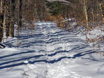
![]()
![]()
![]()
![]()
![]() On Saturday, January 30th, I was ready to get out for a hike after bitterly cold weather and numerous ambulance calls had prevented me from getting out. I always take Sheila with me and I was worried about her getting too cold when the temperatures had been in the teens with a wind-chill much lower. I decided to head for Cabot Mountain from Beech Hill Road as I really wanted to gain some elevation as see what the snow looked like up high. I also maintain this trail for the FLT and wanted to see how it had fared in the ice and wind. I started to get ready at 10:00 AM when the ambulance pager sounded and we were off to cover a call in Liberty. By the time I returned home at noon I didn't feel like going to Cabot so I set my sights a little lower and decided to head to Frick Pond. I put on my long-sleeved Patagonia wool zip top with a light long-sleeved baselayer underneath. I decided to wear my Columbia Titanium insulated pants to keep the chill away with a pair of light tights underneath. I wore my Salomon B-52 insulated boots as they keep my feet warm and dry and work well with snowshoes. I had recently put a pair of Protalus insoles in these shoes and was anxious to see how they performed. The insoles in most hiking boots are a flimsy and flat piece of material. I also applied a new waterproofing and leather preservative which has proved very effective. I went with my new Follow Hollow alpaca sock which are thick and warm and come to my midcalf. I grabbed a pair of Leki poles I have been using all season. I also put on my OR Crocodile gaiters. Finally, I donned my Mammut hoody which blocks the wind and keeps me warm but has enough zippers to dump heat when needed. I decided to wear my TSL Symbioz snowshoes which have a lot of flex and are good for most terrain except for the steepest ascents on the 35s. The binding is very good and they have ample traction. As I was getting ready Sheila stayed near me so that I would not "forget" her but was being a very well-behaved dog. I put my gear in the car and Sheila in the back seat. She was happy to be going anywhere and crouched in the back seat with her head on the console. We left Livingston Manor at 1:10 PM under blue skies with the temperature reading 26 degrees. I drove out the DeBruce Road about 6 miles to Mongaup Road and turned left. I continued up the road to the point where it splits and stayed left on Beech Mountain Road. It was a shirt drive to the parking areas on the left. I pulled into the smaller parking area where no one else was parked. There was only one pickup truck in the larger lot. It surprised me that there weren't more people hiking but I thought they might have finished and left. My plan was to hike up the Flynn Trail to Hodge Pond and then back to the Big Rock Trail. We would follow the Big Rock Trail to the junction with the Quick Lake Trail and take that back to the car. I put on my snowshoes and set my GPS to get ready to hike with the temperature at 21 degrees.
On Saturday, January 30th, I was ready to get out for a hike after bitterly cold weather and numerous ambulance calls had prevented me from getting out. I always take Sheila with me and I was worried about her getting too cold when the temperatures had been in the teens with a wind-chill much lower. I decided to head for Cabot Mountain from Beech Hill Road as I really wanted to gain some elevation as see what the snow looked like up high. I also maintain this trail for the FLT and wanted to see how it had fared in the ice and wind. I started to get ready at 10:00 AM when the ambulance pager sounded and we were off to cover a call in Liberty. By the time I returned home at noon I didn't feel like going to Cabot so I set my sights a little lower and decided to head to Frick Pond. I put on my long-sleeved Patagonia wool zip top with a light long-sleeved baselayer underneath. I decided to wear my Columbia Titanium insulated pants to keep the chill away with a pair of light tights underneath. I wore my Salomon B-52 insulated boots as they keep my feet warm and dry and work well with snowshoes. I had recently put a pair of Protalus insoles in these shoes and was anxious to see how they performed. The insoles in most hiking boots are a flimsy and flat piece of material. I also applied a new waterproofing and leather preservative which has proved very effective. I went with my new Follow Hollow alpaca sock which are thick and warm and come to my midcalf. I grabbed a pair of Leki poles I have been using all season. I also put on my OR Crocodile gaiters. Finally, I donned my Mammut hoody which blocks the wind and keeps me warm but has enough zippers to dump heat when needed. I decided to wear my TSL Symbioz snowshoes which have a lot of flex and are good for most terrain except for the steepest ascents on the 35s. The binding is very good and they have ample traction. As I was getting ready Sheila stayed near me so that I would not "forget" her but was being a very well-behaved dog. I put my gear in the car and Sheila in the back seat. She was happy to be going anywhere and crouched in the back seat with her head on the console. We left Livingston Manor at 1:10 PM under blue skies with the temperature reading 26 degrees. I drove out the DeBruce Road about 6 miles to Mongaup Road and turned left. I continued up the road to the point where it splits and stayed left on Beech Mountain Road. It was a shirt drive to the parking areas on the left. I pulled into the smaller parking area where no one else was parked. There was only one pickup truck in the larger lot. It surprised me that there weren't more people hiking but I thought they might have finished and left. My plan was to hike up the Flynn Trail to Hodge Pond and then back to the Big Rock Trail. We would follow the Big Rock Trail to the junction with the Quick Lake Trail and take that back to the car. I put on my snowshoes and set my GPS to get ready to hike with the temperature at 21 degrees.
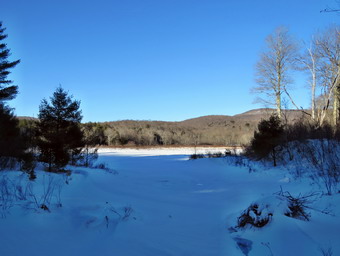 We crossed the road at 1:30 PM, went up and over the snow bank and got on the Flynn Trail to walk around the private property around the cabin at the end of the road. I immediately noticed that there only about 6 to 8 inches of snow but that there was a well defined snowshoe track. I was surprised since many of the people who hike in this area never think of anything but barebooting. At the end of the trail through the woods we turned right on a woods road which is sited along what was once the Beech Mountain Road. This road was the access for the Beech Mountain Boy Scout Camp. We began the ascent on the trail following the snowshoe track. There was one well set track but someone had ignored the track and had walked beside the main track. The day was crisp and clear wit blue skies and some sun. The trail gains a little over 600 feet in 1.75 miles to the highest point at the junction with the Big Rock Trail. We passed through the arch Cindy and I had cut through an enormous hemlock that had fallen across the trail. We walked up the trail with a few stops for me to take some pictures and catch my breath. As we gained elevation the snow got deeper as more had fallen and drifting had occurred. Now I could see as many as four different snowshoe tracks and some from bare boots. I am always amazed when I see people wearing snowshoes but ignoring the common sense practice of making one well-packed track! Using snowshoes is pretty easy but having the common sense to create a track apparently is not. At least the bare hooters had stayed out of the snowshoe track. When we came to the clearing on the right, we passed by as I wanted to stay on the main trail. At this point Sheila came back to me and appareled to be favoring her right front paw. I inspected it and did not find an injury but I did not want a small problem to become a bigger one. A short distance after this point the snow increased to over a foot and I could barely find a well-defined snowshoe track. Either some of the snowshoers had turned around or the track had drifted in. Worse yet the bare booters had decided to walk in what was left of the track. The last half mile or so to the junction with the Big Rock Trail was very difficult as I broke the trail and tried to smooth out the mess the barebooters had made. Several times I called Sheila back to me and then had her run back up the trail. She did a very effective job of helping to break out the trail. As we neared the highest point on the trail at the junction with the Big Rock Trail, I could also feel my legs beginning to get just a little tired especially in my inner thighs. I thought about Sheila's paw and decided we would turn down the Big Rock Trail and leave Hodge Pond for another day. As we approached the junction we could hear snowmobiles coming up the Big Rock Trail from Times Square. We reached the junction with the Big Rock Trail and waited as a group of ten snowmobiles went through the junction and gathered on the trail. All of the machines slowed as they came toward the junction and saw us. We turned left to descend to Times Square. We had hiked the 1.7 miles uphill to the junction and now would have over a mile descent.
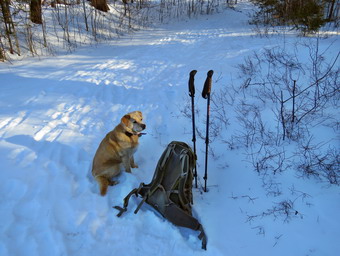 We set a faster pace as we descended the trail passing through the various twists and turns that often make it seem like the bottom of the hill is close. I was glad I had chosen a shorter hike although Sheila did not seem to be having any problems with her paw. The trail was well packed by the snowmobiles and was even easier to hike than when there was no snow as it was very smooth. Two more machines came over a rise and immediately slowed. These were the last people we would see for the day. The trip downhill went quickly and we were soon at Times Square. We continued straight across to stay on the Big Rock Trail. I immediately noticed that all of the tracks were from boot alone and that no one had worn snowshoes. Snowshoes were helpful for me but I could have walked without as so many had chosen to do. What people do not realize is that there many deep impressions in the snow will freeze making walking harder for everyone! We crossed the bridges over the streams that feed Frick Pond where there was some water flowing under the ice that had formed on top. When we came to the large spruce log that had fallen across the trail, I was glad that I had been able to remove it because it made hiking the rail so much easier than having to climb over it. I stopped once under the trees to take some pictures before crossing the wooden walkways that were laden with snow. At the end of the Big Rock Trail, we turned left on the Quick Lake Trail and walked to the bridge over the outlet stream. The sun was beginning to get low in the sky which gave the pond a different look so I stopped to take some shot. I did notice that the breeze coming off the pond was making me colder. I took some pictures of the dam and the pond. I packed up and we continued up the hill to Gravestone Junction. We continued on the trail and back out to the car. The Quick Lake Trail back to the parking area was almost completely frozen over with a combination of packed snow and ice. The small streams that normally cross the trail were also almost completely frozen. At the register we continued straight ahead on the woods road. We arrived at the car at 3:40 PM after hiking 3.9 miles in 2 hours and 5 minutes. The elevation gain was 680 feet. The temperature at the car was 23 degrees. The pickup truck in the large lot was still the only other vehicle.
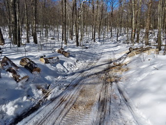
![]()
![]()
![]()
![]()
![]() On Monday, January 25th I was ready to go out for a hike to see how the snowmobile club fared with clearing the trails around Frock and Hodge Pond especially the Loggers Loop that had several large trees down. The temperature at 9:00 AM had risen to 23 degrees which was higher than I thought it would be all day. I started to get ready at 9:30 Am when the temperature was still in the 20's with a slight breeze. I asked Cindy of she wanted to go but she thought it was too cold! I did not have to ask Sheila as she is always ready to hike. I put on my long-sleeved Patagonia wool zip top with a light long-sleeved baselayer underneath. I decided to wear my Columbia Titanium insulated pants to keep the chill away with a pair of light tights underneath. I wore my Salomon B-52 insulated boots as they keep my feet warm and dry and work well with snowshoes. I had recently put a pair of Protalus insoles in these shoes and was anxious to see how they performed. The insoles in most hiking boots are a flimsy and flat piece of material. I also applied a new waterproofing and leather preservative which has proved very effective. I went with my new Follow Hollow alpaca sock which are thick and warm and a little above midcalf. I grabbed a pair of Leki poles I have been using all season. I also put on my OR Crocodile gaiters. Finally, I donned my Mammut hoody which blocks the wind and keeps me warm but has enough zippers to dump heat when needed. I decided to wear my TSL Symbioz snowshoes which have a lot of flex and are good for most terrain except for the steepest ascents on the 35s. The binding is very good and they have ample traction. As I was getting ready Sheila stayed near me so that I would not "forget" her but was being a very well-behaved dog. I put my gear in the car and Sheila in the back seat. She was happy to be going anywhere and crouched in the back seat with her head on the console. At 10:00 AM I headed out the DeBruce Road. After about 6 miles, I turned left on Mongaup Pond Road and stayed left where the road split falling Beech Mountain Road to the trailhead. When we arrived at the parking area, there were no car parked in either lot.
On Monday, January 25th I was ready to go out for a hike to see how the snowmobile club fared with clearing the trails around Frock and Hodge Pond especially the Loggers Loop that had several large trees down. The temperature at 9:00 AM had risen to 23 degrees which was higher than I thought it would be all day. I started to get ready at 9:30 Am when the temperature was still in the 20's with a slight breeze. I asked Cindy of she wanted to go but she thought it was too cold! I did not have to ask Sheila as she is always ready to hike. I put on my long-sleeved Patagonia wool zip top with a light long-sleeved baselayer underneath. I decided to wear my Columbia Titanium insulated pants to keep the chill away with a pair of light tights underneath. I wore my Salomon B-52 insulated boots as they keep my feet warm and dry and work well with snowshoes. I had recently put a pair of Protalus insoles in these shoes and was anxious to see how they performed. The insoles in most hiking boots are a flimsy and flat piece of material. I also applied a new waterproofing and leather preservative which has proved very effective. I went with my new Follow Hollow alpaca sock which are thick and warm and a little above midcalf. I grabbed a pair of Leki poles I have been using all season. I also put on my OR Crocodile gaiters. Finally, I donned my Mammut hoody which blocks the wind and keeps me warm but has enough zippers to dump heat when needed. I decided to wear my TSL Symbioz snowshoes which have a lot of flex and are good for most terrain except for the steepest ascents on the 35s. The binding is very good and they have ample traction. As I was getting ready Sheila stayed near me so that I would not "forget" her but was being a very well-behaved dog. I put my gear in the car and Sheila in the back seat. She was happy to be going anywhere and crouched in the back seat with her head on the console. At 10:00 AM I headed out the DeBruce Road. After about 6 miles, I turned left on Mongaup Pond Road and stayed left where the road split falling Beech Mountain Road to the trailhead. When we arrived at the parking area, there were no car parked in either lot.
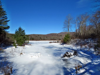 The temperature was 26 degrees with a slight breeze but the sun made it feel a little warmer and the skies were nice and blue. I noticed that the woods road out to the register had a wide and obvious snowshoe track broken. I put on my snowshoes and set my GPS as we headed out the woods road to the Quick Lake Trail at 10:20 AM. I immediately noticed that the snowshoe track was well set and that the bare boot prints ran along the side of the trail well out of the snowshoe track. Developing one well-constructed snowshoe track is the best idea and I was happy people had finally begun to realize that. Wearing snowshoes in more than 8 inches of snow makes a hike more enjoyable for the wearer and shows concern for other hikers. We passed the trail register and headed toward Frick Pond. The trail was snow-covered and all the water I could see was frozen although some must have been flowing under the ice. We continued on the trail to Gravestone Junction where we turned right to get on the yellow Logger's Loop heading toward Times Square. There was a snowshoe track broken on the Logger's Loop which made me happy as it makes the hiking much easier. We headed out the trail which had about a 8 inches of snow off the track. It was cold enough that the snow was not packing on my snowshoes which made the walking even easier. Soon we were hiking downhill toward Times Square still following the snowshoe track that had been set. At Times Square I continued straight ahead on the Logger's Loop which was well-packed by snowmobiles. Just after Times Square there was a large tree that the snowmobile club had cut into sections and moved off the trail. I stopped to take a few shots before moving on. We started a slight uphill climb on the snow-covered trail but the hiking was easy on the packed trail. Just before the trail flattened there was another smaller blowdown that the club had cleared and I took some pictures. Because I was not breaking trail my hips and inner thighs were no aching as they often do.
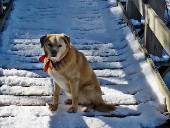 We continued our hike as the trail flattened a little which made the hiking a breeze. I kept looking for other blowdowns that had been cleared but I didn't see any. I was getting very warm in the wool top and tights but I just opened some zippers on my Mammut hoody. I did notice several large plastic culverts along the way. The DEC has started a project to replace the metal culverts and to install culverts were they were needed but did mot exist. That project began at least two years ago but was not completed and the black culverts stand out like a sore thumb. I stopped to take a few shots and then we were off again. It wasn't long before we were walking downhill and the climbing a small hill to Iron Wheel Junction. I was happy to find a trail broken by some bare booters and a cross country skier. I tried to stay out of the ski tracks but the trail is too narrow. I did not see any snowshoe tracks. We turned left to head back toward Frick Pond on the Quick Lake Trail. The trail is slightly downhill which allowed us to keep up a good pace even which was further augmented by the existing track. There were almost no wet spots as most were frozen solid. We came to the small stream in the woods which was almost completely frozen over. I crossed the stream with one big step and avoided getting my snowshoes wet! Walking through the "spruce tunnel" was as easy as the rest of the hike had been. Eventually we walked out the other side where the trail was again covered in snow. We arrived at the junction with the Big Rock Trail and found the trail well packed. We continued on the Quick Lake Trail to the bridge across the outlet of Frick Pond. We crossed the bridge and stopped at the other side. I dropped my pack to get out the camera despite the fact that I have taken hundreds of pictures from this location. The skies were blue with only a few clouds and the scene was a little "warmer" than the temperature. I also took shots of the pond and of Beech Mountain. I took a few more pictures of the outlet stream which was almost completely frozen over. Sheila posed on the bridge and I took her picture also. I packed up and we continued up the hill and back to Gravestone Junction. At Gravestone Junction we continued out the Quick Lake Trail and back to the car without seeing a single person. We arrived at the car at 12:15 PM having hike 3.7 miles in 1 hours and 55 minutes with an elevation gain of 380 feet. The temperature was 28 degrees but felt warmer.
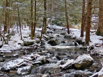
![]()
![]()
![]()
![]()
![]() On Wednesday, January 20th, I was scheduled to meet Lisa at the Neversink Unique area to hike a loop including Denton Falls on the Neversink River and Mullet Brook Falls On Mullet Brook, a tributary to the Neversink. An early morning ambulance call put me behind schedule and it seemed that everything from my gaiters to the gas pump was out to get me. I started getting ready at 9:45 AM when the temperature was 25 degrees with overcast skies. I put on my Mammut long-sleeved crew top with a long-sleeved baselayer since the temperature was cool. I knew this might be overkill but I did it anyway. I decided to wear my Columbia Titanium insulated pants without tights underneath. I wore my Salomon B52 winter boots which are supportive, surprisingly roomy and discontinued. I had recently put a pair of Protalus insoles in these shoes and was anxious to see how they performed. The insoles in most hiking boots are a flimsy and flat piece of material. I also applied a new waterproofing and leather preservative which has proved very effective. I did not expect much snow but wanted to keep my feet warm. I grabbed my Leki external lock poles which I have been using since the spring since twist locks have proved unreliable. I also donned my Mammut hoody which was enough zippers to dump heat when needed. I put on a fleecy orange hat for warmth and wore a light pair of gloves. At the last minutes, I put on my OR Crocodile gaiters to deal with the snow and to keep my lower legs warm. I made sure my Microspikes were in my pack just in case they were needed. I decided to take snowshoes knowing the snow would not be deep but that wearing them would preserve any track that was present or help us to create one. I brought my pair of Tubbs Flex VRT for me and Cindy's pair for Lisa who was coming from Connecticut and did not have snowshoes with her. I got my gear and Sheila in my car and left Livingston Manor at 9:35 AM which I knew might be too late to make it to the end of Katrina Falls Road by 10:00 AM. As I left, snow was falling pretty heavily and the wind was blowing. Many of the trees were already covered in a coat of snow and I was looking forward to taking pictures on our hike. I got on Route 17 and started for Rock Hill. By the time I passed the hospital in Harris the snow was subsiding and it looked as if it had not snowed there at all! I got off the Quickway at exit 109 and turned right on Katrina Falls Road to drive to the end of the road. I parked at 10:05 AM in the small parking area where Lisa was already parked. We said "Hello" and looked at the trail conditions. I was disappointed to find that there was little snow on the ground or on the trees although there was plenty of ice. We decided to leave the snowshoes in the car and wear our spikes. I set my GPS and started off through the gate and down the woods road at 10:10 AM.
On Wednesday, January 20th, I was scheduled to meet Lisa at the Neversink Unique area to hike a loop including Denton Falls on the Neversink River and Mullet Brook Falls On Mullet Brook, a tributary to the Neversink. An early morning ambulance call put me behind schedule and it seemed that everything from my gaiters to the gas pump was out to get me. I started getting ready at 9:45 AM when the temperature was 25 degrees with overcast skies. I put on my Mammut long-sleeved crew top with a long-sleeved baselayer since the temperature was cool. I knew this might be overkill but I did it anyway. I decided to wear my Columbia Titanium insulated pants without tights underneath. I wore my Salomon B52 winter boots which are supportive, surprisingly roomy and discontinued. I had recently put a pair of Protalus insoles in these shoes and was anxious to see how they performed. The insoles in most hiking boots are a flimsy and flat piece of material. I also applied a new waterproofing and leather preservative which has proved very effective. I did not expect much snow but wanted to keep my feet warm. I grabbed my Leki external lock poles which I have been using since the spring since twist locks have proved unreliable. I also donned my Mammut hoody which was enough zippers to dump heat when needed. I put on a fleecy orange hat for warmth and wore a light pair of gloves. At the last minutes, I put on my OR Crocodile gaiters to deal with the snow and to keep my lower legs warm. I made sure my Microspikes were in my pack just in case they were needed. I decided to take snowshoes knowing the snow would not be deep but that wearing them would preserve any track that was present or help us to create one. I brought my pair of Tubbs Flex VRT for me and Cindy's pair for Lisa who was coming from Connecticut and did not have snowshoes with her. I got my gear and Sheila in my car and left Livingston Manor at 9:35 AM which I knew might be too late to make it to the end of Katrina Falls Road by 10:00 AM. As I left, snow was falling pretty heavily and the wind was blowing. Many of the trees were already covered in a coat of snow and I was looking forward to taking pictures on our hike. I got on Route 17 and started for Rock Hill. By the time I passed the hospital in Harris the snow was subsiding and it looked as if it had not snowed there at all! I got off the Quickway at exit 109 and turned right on Katrina Falls Road to drive to the end of the road. I parked at 10:05 AM in the small parking area where Lisa was already parked. We said "Hello" and looked at the trail conditions. I was disappointed to find that there was little snow on the ground or on the trees although there was plenty of ice. We decided to leave the snowshoes in the car and wear our spikes. I set my GPS and started off through the gate and down the woods road at 10:10 AM.
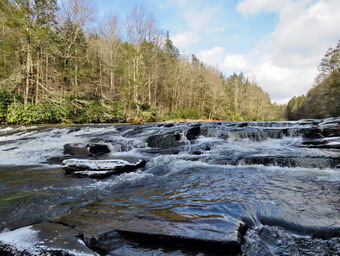 The woods road had spots of ice covered in a thin layer of crunchy snow and I thought the spokes might not be necessary but they proved useful. At the bottom of the hill we turned left to stay on the main blue trail. At this point a yellow spur trail goes down to the river. All of the yellow trails in the area branch off the main blue and red trail, go to a destination like the Neversink River and the return. Just after the turn we came to a small bridge over Wolf Brook. The water in the brook was flowing freely and was as high as I have seen in some time. In addition, the creek had overflowed and flooded the trail beyond the bridge. I decided to stop and take some pictures as it was a beautiful scene without too much bright sunlight. After taking my shots, we crossed the bridge and hiked up a small hill. I noticed the condition of the bridge had deteriorated even more than on previous trips and looked like it would soon collapse. I hope the DEC will fix before it collapses as its present condition does not allow the use of a UTV to transport injured hikers. At the next trail junction, at the top of the short hill, we stayed to the right on the blue trail and descended through before starting up another small hill. The spikes allowed us to simply walk where we wanted and not have to pick our ways round the ice. We stop once to take some shots of the green rhododendron and the white trail which was a nice contrast. At 1.2 miles another yellow spur trail headed down to the river but we stayed on the blue trail. As we approached a bridge, we could hear the water rushing down Mullet Brook. At 1.4 miles we came to the lower bridge across Mullet Brook. The old bridge which was falling apart had been replaced with one based on steel i-beams. I took some pictures of the stream before heading on up the trail. Almost immediately after crossing the bridge, we turned right on the yellow spur trail that goes down to the river at Denton Falls. The trail down to the river is steep in spots and some areas looked dangerous even with spikes. We walked beside the trail where we had better traction and were able to descend to the flatter area below. The blazes are few and far between so hikers had been forging there own routes. Since maintainers are now prevented by the DEC from placing markers, they must be placed by forest rangers or foresters. This regulation means that trails are not as well marked as they should be. When the trail leveled and began to follow the land contours, we ran across several muddy areas which were partly frozen but still wet. These were being widened as more and more hikers tried to find their way around these mud pits. I was careful to keep my footing and walk around the wettest places. At 11:05 AM we had hiked 1.6 miles and we were at the edge of the river.
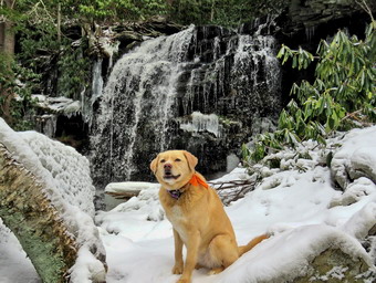 I took off my pack and leaned it against the rock that I usually use as a base. I took my camera out of my pack and began to look for photographic opportunities. The scene was pleasant and the water in the river was high but it lacked the ice and snow I expected to find. We walked out onto the rocks by the river and I called Sheila to make sure she did not jump into the river. The level of water in the river was lower than I had expected but there was enough to make the falls interesting. I took pictures upstream and downstream. I then worked my way to the rocks below and right in front of the falls where I was able to take pictures of the falls and a few more downstream. I had Sheila pose on some rocks and took some pictures with the river in the background. Before we left the river, we made sure to get a drink and a bar. We walked back up the steep trail to the main blue trail and the ascent seemed easier than the descent. We were bale to walk up the icy spots we had avoided on the way down without any Robles. When we got to the main trail, we turned right to continue the loop back to the car. At the top of the hill I briefly thought about going to High Falls but knew that the scenery would not be much different. We stayed to the left to start up the hill. After a brief walk uphill of .15 miles, we turned left onto the short trail down to Mullet Brook Falls. I was wondering what Mullet Brook Falls might look like since there was such a good volume on the main river. As we approached the falls, we could hear the water falling. We walked down to the edge of the stream where I usually stop and I dropped my pack to get out my camera. The water coming over the falls was far from a deluge but was still very beautiful. The sun was still absent so there was little glare. I worked my way up the right side of the rocks below the waterfalls to an area where I could take pictures. There was some thick ice in this area so I took some close-ups and then incorporated it into the pictures of the falls. I then retreated from my position and worked my way to a spot in front of the falls and took some more shots. I took some pictures of the falls and then posed Sheila for a few more. I took a few more shots of the falls using settings to soften the water falling over the rocks. There was ice framing the falls and some large icicles hanging from the rocks. When I was done, we headed back to where I had left my pack where I put away my camera and shouldered my pack. Lisa had been taking some pictures farther downstream and we were both ready to leave. We walked back out to the main trail and turned right to head up the longest and steepest hill on the hike.
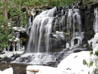 The hill is exposed to the sun so there was very little snow and no much ice. Our spikes kept getting clogged with snow and we stopped often to clear the buildup. When we came to the top of the hill, I knew e were not far from the bridge. The bridge still had several bright orange caution tapes on it and had not been repaired in any way. We walked up to the bridge and saw pieces of bridge and pieces of the tree that had fallen on it. The logs that acted as supports looked like they might be slightly cracked but they held our weight with no problem. We crossed the bridge and continued on the trail which stays level for a short time and then is mostly downhill. After a brief walk, we were at a trail junction 3.1 miles into the hike. Walking straight ahead on the trail leads to the Wolf Lake Multiple Use Area. We turned left and began to descend off the ridge. The walk seemed to go quickly as Lisa and I discussed various topics including activities to get young people away from their computer screens and outside. As we continued to hike downhill, I noticed that the trail remained clear of brush although there were several new and large blowdowns. We walked downhill for some time and eventually came to the trail junction near the bridge over Wolf Creek where we had started the loop earlier. We continued to walk straight ahead over the bridge to return to the parking area. Once on the other side of the brook we made the right turn on the woods road back to the car. We arrived at the parking area at 1:00 PM having hiked 4.7 miles in 2 hours and 50 minutes including the stops at the two falls. The vertical gain was only about 980 feet. We had met no other hikers and there were no other cars parked in the lot. I felt so good I regretted that I did not have time to continue to hike. There was some blue in the sky and the sun was peeking through at times. The temperature was still only 30 degrees.
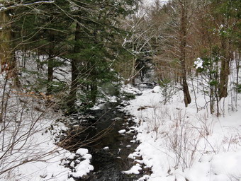
![]()
![]()
![]()
![]()
![]() On Monday, January 18th, I was ready to get in a longer hike and had decided to hike Millbrook Ridge from Alder Lake. Millbrook Ridge is the last "peak" on the 3500 Club list now that Doubletop and Graham are closed. When I mentioned hiking to Cindy, she said she would like to come along but the hike would have to be shorter and flatter. We agreed to go to the Frick Pond area and hike The Quick Lake Trail and Loggers Loop. It wasn't quite 30 degrees when I got up at 7:00 AM but the temperature was going up. I wanted to get an early start but had various tasks to accomplish in the morning so I didn't start getting ready until 10:00 AM when the temperature was 33 degrees. I started gathering my equipment and getting dressed. Sheila had been very quiet but did not let me out of her sight as I was getting ready. I put on my Mammut long-sleeved crew top with a long-sleeved baselayer since the temperature was cool. I knew this might be overkill but I did it anyway. I decided to wear my Columbia Titanium insulated pants without tights underneath. I wore my Salomon B52 winter boots which are supportive, surprisingly roomy and discontinued. I had recently put a pair of Protalus insoles in these shoes and was anxious to see how they performed. The insoles in most hiking boots are a flimsy and flat piece of material. I also applied a new waterproofing and leather preservative which has proved very effective. I did not expect much snow but wanted to keep my feet warm. I grabbed my Leki external lock poles which I have been using since the spring since twist locks have proved unreliable. I also donned my Mammut hoody which was enough zippers to dump heat when needed. I put on a fleecy orange hat for warmth and wore a light pair of gloves. At the last minutes, I put on my OR Crocodile gaiters to deal with the snow and to keep my lower legs warm. I made sure my Microspikes were in my pack just in case they were needed. Cindy and I decided to take snowshoes knowing the snow would not be deep but that wearing them would preserve any track that was present or help us to create one. I got Cindy's Tubb's Flex VRT from the cellar as she had not been snowshoeing this season. While I was there, I decided to wear my TSL Symbioz snowshoes which have a lot of flex and are good for most terrain except for the steepest ascents on the 35s. We got our gear and Sheila in my car and left Livingston Manor at 10:40 AM. I drove out the DeBruce Road about 6 miles to Mongaup Road and turned left to continue up the road to the point where it splits. I stayed left on Beech Mountain Road and drove to the Frick Pond trailhead. When we arrived at the parking areas, we found them both plowed but no cars were in the lots. I pulled into the smaller parking area to park and almost immediately another car came up the road and decided to park in the same lot. As Cindy and I were getting ready, the people in the other car did not exit their vehicle. The lies were completely overcast and it looked like it might snow with the temperature right at 32 degrees. I set my GPS and we both put on our snowshoes. We carried are spikes although I could not think of a place we would use them.
On Monday, January 18th, I was ready to get in a longer hike and had decided to hike Millbrook Ridge from Alder Lake. Millbrook Ridge is the last "peak" on the 3500 Club list now that Doubletop and Graham are closed. When I mentioned hiking to Cindy, she said she would like to come along but the hike would have to be shorter and flatter. We agreed to go to the Frick Pond area and hike The Quick Lake Trail and Loggers Loop. It wasn't quite 30 degrees when I got up at 7:00 AM but the temperature was going up. I wanted to get an early start but had various tasks to accomplish in the morning so I didn't start getting ready until 10:00 AM when the temperature was 33 degrees. I started gathering my equipment and getting dressed. Sheila had been very quiet but did not let me out of her sight as I was getting ready. I put on my Mammut long-sleeved crew top with a long-sleeved baselayer since the temperature was cool. I knew this might be overkill but I did it anyway. I decided to wear my Columbia Titanium insulated pants without tights underneath. I wore my Salomon B52 winter boots which are supportive, surprisingly roomy and discontinued. I had recently put a pair of Protalus insoles in these shoes and was anxious to see how they performed. The insoles in most hiking boots are a flimsy and flat piece of material. I also applied a new waterproofing and leather preservative which has proved very effective. I did not expect much snow but wanted to keep my feet warm. I grabbed my Leki external lock poles which I have been using since the spring since twist locks have proved unreliable. I also donned my Mammut hoody which was enough zippers to dump heat when needed. I put on a fleecy orange hat for warmth and wore a light pair of gloves. At the last minutes, I put on my OR Crocodile gaiters to deal with the snow and to keep my lower legs warm. I made sure my Microspikes were in my pack just in case they were needed. Cindy and I decided to take snowshoes knowing the snow would not be deep but that wearing them would preserve any track that was present or help us to create one. I got Cindy's Tubb's Flex VRT from the cellar as she had not been snowshoeing this season. While I was there, I decided to wear my TSL Symbioz snowshoes which have a lot of flex and are good for most terrain except for the steepest ascents on the 35s. We got our gear and Sheila in my car and left Livingston Manor at 10:40 AM. I drove out the DeBruce Road about 6 miles to Mongaup Road and turned left to continue up the road to the point where it splits. I stayed left on Beech Mountain Road and drove to the Frick Pond trailhead. When we arrived at the parking areas, we found them both plowed but no cars were in the lots. I pulled into the smaller parking area to park and almost immediately another car came up the road and decided to park in the same lot. As Cindy and I were getting ready, the people in the other car did not exit their vehicle. The lies were completely overcast and it looked like it might snow with the temperature right at 32 degrees. I set my GPS and we both put on our snowshoes. We carried are spikes although I could not think of a place we would use them.
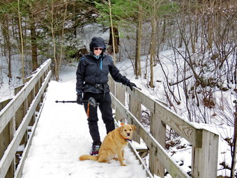 We started out the woods road to the register and found that many people had been on the trail but none had worn snowshoes. There was very little snow but there were already some frozen footprints which were now thawing. We tried to walk single file so that we could smooth a track knowing the next hikers would probably be in bare boots. The woods road was mostly covered in snow with the only open water in the small streams that transect the trail. The snowshoes were working well and I did not notice that walking was much harder with them. At Gravestone Junction we stayed left on the Quick Lake trail heading toward the bridge at the outlet to Frick Pond. When we arrived at the bridge, I almost passed in taking some pictures but decided to stop as I always due and snap some shots. After packing up we continued over the bridge and along the west side of Frick Pond. At the junction with the Big Rock Trail, we headed left on the Quick Lake trail where almost everyone else had turned right around the pond. The snow was now between 4 and 6 inches and the footprints were annoying. I tried to widen the narrow track and smooth over the depressions. We walked through the spruce tunnel and came to the small stream across the trail. I thought the water level was a little high so I walked upstream to cross. Cindy somehow made it across the wider area on the trail. The walk up the trail was pretty easy but we did move some branches out of the way. There was no open water or soft mud to impede our progress. The bare boot prints continued to be a problem. I was pretty sure when we got to Iron Wheel Junction There would be snowmobile tracks which would make the walking easier. When we got to the junction, we were both surprised to see untouched snow to the right on the Logger's Loop. We turned right and began breaking trail through no more than six inches of snow. This was actually easier than trying to widen the narrow bare boot track!
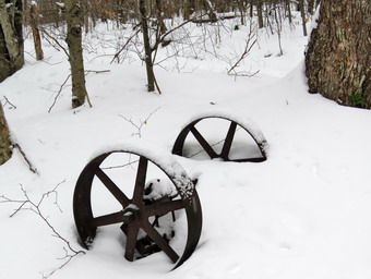 As we walked we continued to clear some small branches. We both noticed a few snowflakes in the air and a breeze that had kicked up. At the same time there were some rays of sunlight but we could see they would be short-lived. We ran into the large cherry tree that had broken off high up and fallen so that it was arching across the trail. This tree was not blocking the trail and it was clear it was not coming down soon. We passed by the seasonal pond on the left side of the trail and continued downhill to Times Square. As we passed through Times Square, we looked back to find two hikers with their dog on a leash. I noted they were not wearing snowshoes and had probably chewed up the track we had just laid down! We continued straight head on the Logger's Loop while the others turned right onto the Big Rock Trail. We walked up a slight hill and out toward Gravestone Junction. By now the snow was falling noticeably so I elected not to take pictures and get back to the car. We turned left at the Gravestone Junction and headed back to the car on the woods road. At the trail register, we continued straight ahead to retrace our route back to the parking area. It was 1:15 PM and we had spent 2 hour and 15 minutes hiking 3.6 miles on snowshoes. The elevation gain was a modest 395 feet. The temperature still 32 degrees and as I pulled away from the parking area five more cars came up the road!
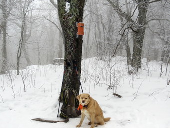
![]()
![]()
![]()
![]()
![]() On Friday, January 15th, I had planned for some time to hike Halcott. I am not sure why I had this on my mind but I had not been there in some time. When I got up at 8:00 AM it was 28 degrees but I new that would rise some during the day. I started to get ready at 8:30 AM with Sheila hovering around me. I put on my Mammut long-sleeved crew top with a long-sleeved baselayer since the temperature was cool. I knew this might be overkill but I did it anyway. I decided to wear my Columbia Titanium insulated pants with a light pair of tights underneath. I wore my Salomon B52 winter boots which are supportive, surprisingly roomy and discontinued. I had recently put a pair of Protalus insoles in these shoes and was anxious to see how they performed. The insoles in most hiking boots are a flimsy and flat piece of material. I also applied a new waterproofing and leather preservative which has proved very effective. I did not expect much snow but wanted to keep my feet warm. I grabbed my Leki external lock poles which I have been using since the spring since twist locks have proved unreliable. I also donned my Mammut hoody which was enough zippers to dump heat when needed. I put on a fleecy orange hat for warmth and wore a light pair of gloves. At the last minutes, I put on my OR Crocodile gaiters to deal with the snow and to keep my lower legs warm. I made sure my Microspikes were in my pack just in case they were needed. I got my gear and Sheila in my car and left Livingston Manor at 9:10 AM. Sheila kept me in sight as I got ready to go making sure she would not be forgotten. I put my gear in the car and Sheila in the backseat. The skies were blue completely overcast, there was some moisture in the air and a breeze was blowing. I headed out DeBruce Road and turned left at the end on Route 47 to head toward Big Indian and Route 28. There were no cars parked at Biscuit Brook. The Slide Mountain parking area had four cars parked. The parking area for Giant Ledge and Panther was a little more than half full but looked very icy. As we passed these spots where we have hiked before Sheila would "moan" as if she was asking me if we could stop and hike. I turned right on Route 28 and then left on Route 42 to head toward Spruceton. After 5 miles, I pulled into the parking area for Halcott on the right side of the road. There was one other car parked at an angle taking up at least 2 parking spots. I began to get ready and decided to keep my spikes in my pack until they were needed. I set my GPS and started up the slope near the falls at 10:20 AM.
On Friday, January 15th, I had planned for some time to hike Halcott. I am not sure why I had this on my mind but I had not been there in some time. When I got up at 8:00 AM it was 28 degrees but I new that would rise some during the day. I started to get ready at 8:30 AM with Sheila hovering around me. I put on my Mammut long-sleeved crew top with a long-sleeved baselayer since the temperature was cool. I knew this might be overkill but I did it anyway. I decided to wear my Columbia Titanium insulated pants with a light pair of tights underneath. I wore my Salomon B52 winter boots which are supportive, surprisingly roomy and discontinued. I had recently put a pair of Protalus insoles in these shoes and was anxious to see how they performed. The insoles in most hiking boots are a flimsy and flat piece of material. I also applied a new waterproofing and leather preservative which has proved very effective. I did not expect much snow but wanted to keep my feet warm. I grabbed my Leki external lock poles which I have been using since the spring since twist locks have proved unreliable. I also donned my Mammut hoody which was enough zippers to dump heat when needed. I put on a fleecy orange hat for warmth and wore a light pair of gloves. At the last minutes, I put on my OR Crocodile gaiters to deal with the snow and to keep my lower legs warm. I made sure my Microspikes were in my pack just in case they were needed. I got my gear and Sheila in my car and left Livingston Manor at 9:10 AM. Sheila kept me in sight as I got ready to go making sure she would not be forgotten. I put my gear in the car and Sheila in the backseat. The skies were blue completely overcast, there was some moisture in the air and a breeze was blowing. I headed out DeBruce Road and turned left at the end on Route 47 to head toward Big Indian and Route 28. There were no cars parked at Biscuit Brook. The Slide Mountain parking area had four cars parked. The parking area for Giant Ledge and Panther was a little more than half full but looked very icy. As we passed these spots where we have hiked before Sheila would "moan" as if she was asking me if we could stop and hike. I turned right on Route 28 and then left on Route 42 to head toward Spruceton. After 5 miles, I pulled into the parking area for Halcott on the right side of the road. There was one other car parked at an angle taking up at least 2 parking spots. I began to get ready and decided to keep my spikes in my pack until they were needed. I set my GPS and started up the slope near the falls at 10:20 AM.
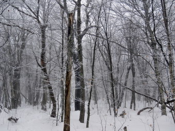 As I worked my way up the slope, it was very icy and it was clear I should have put on my spikes. I made it to the top and followed a track across the creek above the falls. I immediately stopped to put on my spikes and felt much more secure once they were on. In my previous trips I had usually headed west and slightly north to gain the ridge and then walked that ridge to Halcott. I had also hiked north to Sleeping Lion, a peak on the Catskill Hundred Highest list, and then southwest to Halcott. Both of these routes avoid some of the steepest climb to the summit of Halcott. The track that I was following appeared to be made by 4 to 6 people so I decided to follow it. There was several inches of snow on the ground which was packed in the track I was following. The track headed WSW toward Bushnellsville Creek and crossed a few wet areas. I knew that the creek was small but had cut a deep drainage that could not be crossed until much further up the mountain. At about .4 miles, the track came to a point overlooking that deep drainage and turned right. From here the track headed northwest and up gaining elevation until it started to sidehill and flatten at .75 miles turning more west. We crossed the drainage at .85 miles. We were now surrounded by fog and a light mist. I was already a little tired but I kept think 'At least there are no nettles!' At this point the climbing began for real. Over the next .6 miles we gained over 950 feet with an average grade of 28% and a few steeper areas. The track headed southwest and then at 1.1 miles started to veer south. On one of the steepest section I spotted the other hiker coming down toward us with his dog. I stepped aside with Sheila and he put his dog on a leash as he passed. We exchanged greetings and he parted with 'You still have a long way to go!' I knew that there was still some climbing but I did not need his affirmation. As we continued toward the summit I considered nailing out several times. I kept telling myself we were close and the return trip was all downhill. It did not help that we would climb a steep section to find a slightly more level spot only to see another climb ahead. This happened three times until we finally got to the summit plateau which looked familiar.
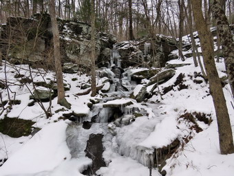 The wind on the top was gusting to 30 mph and there was a layer of ice on all the trees. I had been warm up to this point but was starting to cool off. The track to the canister wound back and froth until I finally spotted an orange blob on a tree. I was very happy and I immediately took off my pack and got out the camera. I took pictures of Sheila, my pack and the canister. I also took some shots of the ice on the trees and the bleakness of the summit. It was at this point I saw another hiker approaching. We greeted each other and he got the book out of the canister. He signed in and then handed it to me and I signed my name and Sheila. We talked for a moment and then both decided it would be good to start down and get out of the wind. Sheila and I started to follow the track back down the mountain. I looked around and did not see the other hiker and assumed he had tried a different route. I started down as fast as I could which went well for a while until we hit the very steep sections. As I was negotiating one section, the other hiker showed up. I stepped aside for him to pass but after went by us he slowed a little and we stayed together for the rest of the descent. The hiker was from Saylorsville, Pennsylvania and was staying for the weekend to get in some Catskill Peaks. I learned he had hiked Balsam earlier in the day and complimented him. I had considered doing Rusk after Halcott but had quickly decided against that. We had a very pleasant talk on the way down and parted after descending to the falls. I walked over to the falls and took quite a few shots from different angles. We walked down to the car arriving at 1:15 PM after hiking 3.2 miles in 2 hours and 50 minutes. The elevation gain was 1740 feet. Our speed was 1.1 mph when moving and only 1.4 overall! Despite the short distance, the steep climb had proved challenging for me.
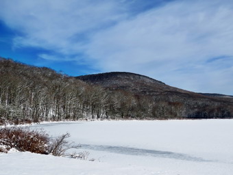
![]()
![]()
![]()
![]()
![]() On Wednesday, January 13th, I had planned to do a longer hike taking in some 3500 foot peaks but Lisa wanted to hike to the beaver Meadow (Pond) lean-to at Alder Lake so I agreed to go. My grandson, Bryce, would also be at the houses and I planned to take him also. Bryce had a 9:00 AM Zoom meeting with his teacher so I arranged to pick up Lisa at 10:00 AM at her house. When I got up at 8:30 AM it was 26 degrees but I new that would rise some during the day. I started to get ready at 9:30 AM with Sheila hovering around me. I put on my Patagonia wool long-sleeved top with a long-sleeved baselayer since the temperature was cool. I knew this might be overkill but I did it anyway. I decided to wear my Columbia Titanium insulated pants with a light pair of tights underneath. I wore my Salomon B52 winter boots which are supportive, surprisingly roomy and discontinued. I had recently put a pair of Protalus insoles in these shoes and was anxious to see how they performed. The insoles in most hiking boots are a flimsy and flat piece of material. I also applied a new waterproofing and leather preservative which has proved very effective. I did not expect much snow although the possibility of mud was on my mind. I grabbed my Leki external lock poles which I have been using since the spring since twist locks have proved unreliable. I also donned my Mammut hoody which was enough zippers to dump heat when needed. I put on a Mountain Hardwear hat and wore a light pair of gloves. At the last minutes, I put on my OR Crocodile gaiters to deal with the snow and mud which I was sure we would find. I made sure my Microspikes were in my pack just in case they were needed. I got my gear and Sheila in my car and left Livingston Manor at 10:00 AM. Sheila kept me in sight as I got ready to go making sure she would not be forgotten. I put my gear in the car and Sheila and Bryce in the backseat and we left Livingston Manor at 9:50 PM. I drove out the driveway and turned left on Old Route 17 toward Roscoe. Just outside of town I turned right on the Beaverkill Road and headed north. At the top of Johnston Mountain, I pulled into Lisa's driveway to pick her up. I continued on the Beaverkill Road through Lew Beach and Turnwood toward Alder Creek Road where I made a left. Lisa pointed out the Beaverkill Fish Hatchery to Bryce and told him a little about the history. Alder Creek Road had almost washed out in one of the rainstorms in the fall but the Town of Hardenburgh had done a great job and the area that was effected had been reinforced and showed no further signs of erosion. I continued to the end on the road where I turned right toward Alder Lake. The gate to the access road was locked but there were no cars parked in the few spaces outside the gate. I was a little surprised as Alder Lake in popular and has become more popular now that Millbrook Ridge is the temporary alternative for Graham Mountain until the 3500 Club can determine the status of that mountain with the Gould family. The temperature was now 30 degrees but the breeze hit me when I got out of the car. The tracks of the other hikers showed someone may have worn snowshoes but I knew this was unnecessary from previous hikes. I did see cross country ski tracks and a suggestion that some people had worn skis. I hoped the drops of blood on the snow were from fish caught on the lake. The skies were completely overcast with no blue and no sun. I set my GPS and we started up the access road at 10:25 AM.
On Wednesday, January 13th, I had planned to do a longer hike taking in some 3500 foot peaks but Lisa wanted to hike to the beaver Meadow (Pond) lean-to at Alder Lake so I agreed to go. My grandson, Bryce, would also be at the houses and I planned to take him also. Bryce had a 9:00 AM Zoom meeting with his teacher so I arranged to pick up Lisa at 10:00 AM at her house. When I got up at 8:30 AM it was 26 degrees but I new that would rise some during the day. I started to get ready at 9:30 AM with Sheila hovering around me. I put on my Patagonia wool long-sleeved top with a long-sleeved baselayer since the temperature was cool. I knew this might be overkill but I did it anyway. I decided to wear my Columbia Titanium insulated pants with a light pair of tights underneath. I wore my Salomon B52 winter boots which are supportive, surprisingly roomy and discontinued. I had recently put a pair of Protalus insoles in these shoes and was anxious to see how they performed. The insoles in most hiking boots are a flimsy and flat piece of material. I also applied a new waterproofing and leather preservative which has proved very effective. I did not expect much snow although the possibility of mud was on my mind. I grabbed my Leki external lock poles which I have been using since the spring since twist locks have proved unreliable. I also donned my Mammut hoody which was enough zippers to dump heat when needed. I put on a Mountain Hardwear hat and wore a light pair of gloves. At the last minutes, I put on my OR Crocodile gaiters to deal with the snow and mud which I was sure we would find. I made sure my Microspikes were in my pack just in case they were needed. I got my gear and Sheila in my car and left Livingston Manor at 10:00 AM. Sheila kept me in sight as I got ready to go making sure she would not be forgotten. I put my gear in the car and Sheila and Bryce in the backseat and we left Livingston Manor at 9:50 PM. I drove out the driveway and turned left on Old Route 17 toward Roscoe. Just outside of town I turned right on the Beaverkill Road and headed north. At the top of Johnston Mountain, I pulled into Lisa's driveway to pick her up. I continued on the Beaverkill Road through Lew Beach and Turnwood toward Alder Creek Road where I made a left. Lisa pointed out the Beaverkill Fish Hatchery to Bryce and told him a little about the history. Alder Creek Road had almost washed out in one of the rainstorms in the fall but the Town of Hardenburgh had done a great job and the area that was effected had been reinforced and showed no further signs of erosion. I continued to the end on the road where I turned right toward Alder Lake. The gate to the access road was locked but there were no cars parked in the few spaces outside the gate. I was a little surprised as Alder Lake in popular and has become more popular now that Millbrook Ridge is the temporary alternative for Graham Mountain until the 3500 Club can determine the status of that mountain with the Gould family. The temperature was now 30 degrees but the breeze hit me when I got out of the car. The tracks of the other hikers showed someone may have worn snowshoes but I knew this was unnecessary from previous hikes. I did see cross country ski tracks and a suggestion that some people had worn skis. I hoped the drops of blood on the snow were from fish caught on the lake. The skies were completely overcast with no blue and no sun. I set my GPS and we started up the access road at 10:25 AM.
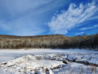 There was some ice beneath the snow but I was not slipping much and the walking was not much more difficult than on dry ground. We walked uphill for about .35 miles to the parking area which, of course, was completely empty. Lisa told Bryce a story about brining friends to snowshoes at Alder Lake for the first time. We headed down to the "lawn" passing by the stone foundations which marked the last remnants of the Coykendall Mansion. We walked toward the trail around the left side of the lake. As we walked along the trail we found a few spots of ice and open water. The brush and branches that had overgrown the trail were now dead and the walking was much easier. Sheila was happy to be out and ran ahead and then returned to us. I decided that since it was late I would not stop for any more pictures on the way out. Lisa suggested that we walk silently to the bridges over the inlet streams so that we might see some otters. I had never seen an otter at Alder Lake but we walked with making any noise until we passed the bridges. We crossed the bridges on the trail near the head end of the lake and continued on the trail toward the junction with the Millbrook Ridge Trail. At the trail junction, we turned left to head toward the lean-to on the Millbrook Ridge Trail. The trail was covered in snow with a few patches of ice here and there. The blowdowns we encountered were all easy to step over but I knew I would need to get a crew out in the spring to remove them from trail. Bryce and I did remove a few larger blowdowns by loosening them and pulling them off the trail or by breaking them off. The trail is pretty obvious and the blazes easy to see in mist places and we followed the tracks of other hikers. For the next 1.5 miles the trail climbed and then leveled off several times. The elevation gain is several hundred feet but the grade is never more than 12% and averages around 6%. There isn't too much to see along the way but this day was very pleasant because the snow adds a beauty to the woods. We enjoyed the sounds and sights of Alder Creek as it flows parallel to the trail much of the way. I looked over at the creek and saw that there was a good volume of water and that the rocks were covered in snow and ice. I thought about trying to get down to the creek bed for some shots but decided against it. The trail leveled off at a beaver meadow and we crossed a small stream that feeds it. At 2.2 miles we began the last climb and I found that the snow had a little more ice underneath it. Bryce and I looked up and found that Lisa had decided to forge ahead without us but we kept our steady pace. I was slipping and sliding some but decided I would not stop to put the spikes on as the climb was short.
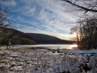 Soon we arrived at the beaver pond. Where there had once been a beaver meadow, there was now a pond with a dam and a beaver lodge. Lisa had walked out to the beaver dam and was now waiting for us on the trail. We walked over to the lean-to to find it empty although there were signs people had recently been there. It was noon so we got a drink and a bar before starting back. It was then that Bryce informed me he had a Zoom meeting at 2:00 PM as wells as 3:00 PM. I knew the trip back would be quicker than the trip out but decided we should get going right away. We packed up and went back out to the trail assuming Lisa was right behind us. After a few minutes I looked back and saw she was still at the lean-to. We decided to press on as I knew she would catch up to us. As we came to the spot on the trail opposite the beaver dam, I thought about stopping to take some pictures but decided to bypass the opportunity this time. I realized that the return trip would be much easier as it was almost all downhill. I knew that it would be important to watch our foot placements so that we did not fall on steeper descents. Bryce had not hiked in some time and was a little tired but we set a good pace. Soon we saw Lisa was just behind us. She caught us and passed us and we chose not to join the race! The walk did go quickly and we were soon at the loop trail around Alder Lake where we turned right to return the way we came. We did catch up to Lisa as she was taking a few pictures near the lake. It was difficult but we were able to match her pace and even get in a little conversation as we walked along the shore of the lake. I was glad the skies were still overcast and the scene was not conducive to photography. We walked up the hill to the parking area and I considered walking down to the creek to take some pictures of the waterfalls but I knew we were on a tight schedule. Lisa sign out at the register an we walked out the access road and down the hill to the car. We were back at the car at 1:05 PM after hiking 5.32 miles in 2 hours and 40 minutes. The elevation gain was 745 feet. The walk out had taken 1 hour and 25 minutes while the trip back was 1 hour and 10 minutes! Our overall speed was 2 MPH with moving average of 2.12 MPH.
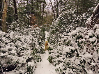
![]()
![]()
![]()
![]()
![]() On Tuesday, January 12th I was ready to get out and do another real hike and considered Halcott or Rusk or maybe both. In the end I decided to go to Yagerville to hike to Vernooy Kill Falls and then loop back to the car using the Long Path and snowmobile trails. This was a new hike for me which doesn't happen too often and I estimated the distance to be between 6 and 8 miles. When I started to get ready at 9:30 AM the temperature was 26 degrees but there was no wind blowing. The skies were overcast and there was moisture in the air which made it seem raw. Sheila was excited to be getting out and would not let us out of her sight. I put on my Patagonia wool long-sleeved top with a long-sleeved baselayer since the temperature was cool. I knew this might be overkill but I did it anyway. I decided to wear my Columbia Titanium insulated pants with a light pair of tights underneath. I wore my Salomon B52 winter boots which are supportive, surprisingly roomy and discontinued. I had recently put a pair of Protalus insoles in these shoes and was anxious to see how they performed. The insoles in most hiking boots are a flimsy and flat piece of material. I also applied a new waterproofing and leather preservative which has proved very effective. I did not expect much snow although the possibility of mud was on my mind. I grabbed my Leki external lock poles which I have been using since the spring since twist locks have proved unreliable. I also donned my Mammut hoody which was enough zippers to dump heat when needed. I put on a Mountain Hardwear hat and wore a light pair of gloves. At the last minutes, I put on my OR Crocodile gaiters to deal with the snow and mud which I was sure we would find. I made sure my Microspikes were in my pack just in case they were needed. I got my gear and Sheila in my car and left Livingston Manor at 10:00 AM. I drove east on State Route 17 to Liberty and then got on Route 55 headed toward Grahamsville. After passing the TriValley school, I turned left on Route 55A and drove toward Sundown. Where Route 55A turned right, I continued straight ahead on Sundown Road to Sundown. In Sundown I turned right just after the bridge on Greenville Road and drove to the top of the hill to the intersection with Dymond Road. I turned left on Dymond Road and parked in the small pulloff on the right. The temperature was 30 degrees as I set my GPS to begin the hike. We crossed the road to start out on a snowmobile trail toward Vernooy Kill Falls.
On Tuesday, January 12th I was ready to get out and do another real hike and considered Halcott or Rusk or maybe both. In the end I decided to go to Yagerville to hike to Vernooy Kill Falls and then loop back to the car using the Long Path and snowmobile trails. This was a new hike for me which doesn't happen too often and I estimated the distance to be between 6 and 8 miles. When I started to get ready at 9:30 AM the temperature was 26 degrees but there was no wind blowing. The skies were overcast and there was moisture in the air which made it seem raw. Sheila was excited to be getting out and would not let us out of her sight. I put on my Patagonia wool long-sleeved top with a long-sleeved baselayer since the temperature was cool. I knew this might be overkill but I did it anyway. I decided to wear my Columbia Titanium insulated pants with a light pair of tights underneath. I wore my Salomon B52 winter boots which are supportive, surprisingly roomy and discontinued. I had recently put a pair of Protalus insoles in these shoes and was anxious to see how they performed. The insoles in most hiking boots are a flimsy and flat piece of material. I also applied a new waterproofing and leather preservative which has proved very effective. I did not expect much snow although the possibility of mud was on my mind. I grabbed my Leki external lock poles which I have been using since the spring since twist locks have proved unreliable. I also donned my Mammut hoody which was enough zippers to dump heat when needed. I put on a Mountain Hardwear hat and wore a light pair of gloves. At the last minutes, I put on my OR Crocodile gaiters to deal with the snow and mud which I was sure we would find. I made sure my Microspikes were in my pack just in case they were needed. I got my gear and Sheila in my car and left Livingston Manor at 10:00 AM. I drove east on State Route 17 to Liberty and then got on Route 55 headed toward Grahamsville. After passing the TriValley school, I turned left on Route 55A and drove toward Sundown. Where Route 55A turned right, I continued straight ahead on Sundown Road to Sundown. In Sundown I turned right just after the bridge on Greenville Road and drove to the top of the hill to the intersection with Dymond Road. I turned left on Dymond Road and parked in the small pulloff on the right. The temperature was 30 degrees as I set my GPS to begin the hike. We crossed the road to start out on a snowmobile trail toward Vernooy Kill Falls.
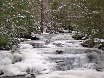 As we started the sign indicated 1.8 miles to the falls but I knew the signs were often incorrect. I knew that the falls were lower than where I had parked so that we would be descending quite a bit on the way to the falls. The first part of the trail was bare in some places with ice and some snow. I was surprised to see several sets of footprints going in both directions. Eventually the trail became snow covered with only a few inches of snow most of which was packed. There was no need to wear spikes and the walking went quickly. After a little more than half a mile we ran into several large blowdowns which forced me to drop my pack to duck under or to walk around the end. I suspected that no one had been on this trail with a snowmobile in some time and since it was not a hiking trail very little maintenance had been done. Sheila alerted and I looked up to see a young man stopped near a small stream. I put Sheila on her leash as we approached him. I stopped to talk and found out that he was doing the hike in the opposite direction having started at Upper Cherrytown Road. He told me he was from Ithaca and was now living in Poughkeepsie and attending the State University at New Paltz. He was building up his mileage so that he could backpack from Poughkeepsie to Ithaca using the Long Path and Finger Lake Trail. We parted knowing that we would see each other at least one more time as we were both doing the loop. We walked a little farther and entered an area where the laurel was encroaching on the trail. I stopped to take some pictures of the snow on the laurel and of Sheila on the trail. We started a short ascent before dropping to the falls and I saw another hiker ahead. He walked well off the trail and made a cryptic comment as we passed. I wished him well and we continued on our way. Sooner than I thought we were descending to the falls. I took a picture of the bridge and then walked out onto the bridge to take pictures of the falls. I was surprised to see that the falls were almost completely frozen over when the water had been freely flowing in late December. I dropped my pack and poles on the other side of the bridge and took my camera. I took pictures from the bridge and then walked downstream along the bank to take some more shots. I was able to walk out onto a rock that did not have ice and get some pictures of the falls head on. After getting a number of shots, I returned to the pack and stowed the camera. I got a drink and put a bar in my coat to warm. I shouldered my pack and we started out from the falls headed north on the Long Path.
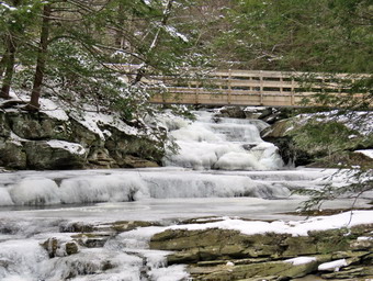 Since the falls was the lowest point on the hike, I knew we would have to ascend some but by looking at the map there were no steep climbs. As we walked along, I was surprised that there were no markings on the trail at all. I knew it was about a mile to where the Long Path split from the snowmobile trail and I hoped it was well marked. Sheila once again altered and I saw a very large dog coming our way. It looked like a young golden retriever but it was huge and its owners had no control. He came over to Sheila and kept running around us as the male owner lamely tried to get hold of him. I thought I has going to have to whack the dog with my hiking pole but knew it would be more appropriate to chastise the owner! He never was able to grab the dog but herded him away as Sheila and I walked the other way. At 2.8 miles the Long Path made a left turn away from the snowmobile trail which continued to Trail's End. We now had to climb Polple Hill which was rather easy as the distance was about .3 miles and the elevation gain less than 200 feet at a 10% grade. After the hill, the trail began to roll but mostly descended to Spencer Road. Along the way we met the young man we had met before. We stopped for a short conversation. He told me Spencer Road was an unmaintained and seasonal road which was in pretty good shape. He also told me that the turn toward Dymond Road and away from the Long Path was a little tricky. We part and soon Sheila and I arrived at Spencer Road which had very little snow, some ice and a few vehicle tracks. We continued to descend and head north until at 4.7 miles the road began to ascend. It was a very easy slope which was hardly even noticeable. We eventually came to the Vernooy Kill again which flowed under the road through a culvert. I stopped to take a few more pictures and to check Avenza on my phone. I had left the iPhone in my pack and the battery was quickly dying.
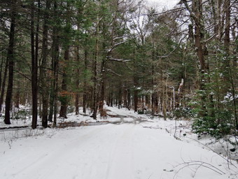 There was still some distance to go before the turn off the Long Path and we set a quick pace. Our pace was slowed in some places by the ice on the road but I walked around it and Sheila did not seem to mind. As we neared where I though the turn should be, a road turned to the left. I looked down the road and could see one markers so I decided to continue on a little farther. Just as I was considering turning back, we came to a group of signs at 5.7 miles indicating that the Long Path veered to the right and the snowmobile trail continued almost straight ahead for .9 miles to Dymond Road. I was glad I now knew where we were going and we set off along the rolling road. As we neared Dymond Road, I saw a pickup truck parked on the side of Spencer Road with someone getting out of the truck. As a courtesy, I put Sheila on her leash just as two hunting dogs boiled out of the truck and headed for us. Once again, the owner had little control over his dogs and one aggressively approached us. I chased him away and the owner finally got him on a leash. As the other dog was growling at us, the owner assured me he was harmless! We hurried past the truck and continued on to Dymond Road at 6.5 miles. We turned left on the road which was plowed and sanded. The road descended slightly and then began to climb back to the intersection where I had parked the car. We walked a half Nile to the south along the road to the car. We were back at the car at 2:10 PM after hiking 7 miles in 3.5 hours. The elevation gain was 735 feet. Our overall speed was just over2 mph with the moving average being 2.4 mph which I considered very respectable.
![]()
![]()
![]()
![]() On Monday, January 11th I knew I had to get out and hike if only for the exercise. I decided to go across the street to hike on Round Top and Cindy agreed to go along. Sheila seemed very happy that we would be going out and that both of us were going with her. At 12:00 PM, we started to get ready with the temperature hanging at 26 degrees and overcast skies. I put on my Mammut long-sleeved crew top with a long-sleeved baselayer since the temperature was cool. I decided to wear my Columbia Titanium insulated pants without a baselayer underneath. I wore my Salomon B52 winter boots which are supportive, surprisingly roomy and discontinued. I had recently put a pair of Protalus insoles in these shoes and was anxious to see how they performed. The insoles in most hiking boots are a flimsy and flat piece of material. I did not expect much snow and knew that what was once mud would now be frozen mud. I grabbed my Leki external lock poles which I have been using since the spring since twist locks have proved unreliable. I also donned my Mammut hoody which was enough zippers to dump heat when needed. I put on a fleecy orange hat and wore a light pair of gloves. We stepped out of the house at 12:30 PM. We had decided to put on spikes as we did not know how much ice we would find on the trails. I grabbed Sheila's leash from the car and put it on her to safely cross the street. We walked up the driveway and crossed the street. Since we had our spikes on, we walked across the field next to the church so we did not dull the spikes on the road. When we stepped onto the parking lot, there was a layer of ice and I was glad we had the spikes. We began the ascent of the steepest hill behind the church that was covered in packed snow and ice. We both walked up the hill getting a good grip from the spikes. The hill is short but gets the circulation pumping and is the steepest and longest climb on the "trail." Sheila always helps me up the hill by giving me a good pull in her leash living up to the husky in her blood. When we got to the top of the hill, we stopped to look around at the hills around town. We started on the trail by turning left at the trailhead. There were a lot of boot tracks on the trails but I could not tell whether they were from earlier in the day or from days before.
On Monday, January 11th I knew I had to get out and hike if only for the exercise. I decided to go across the street to hike on Round Top and Cindy agreed to go along. Sheila seemed very happy that we would be going out and that both of us were going with her. At 12:00 PM, we started to get ready with the temperature hanging at 26 degrees and overcast skies. I put on my Mammut long-sleeved crew top with a long-sleeved baselayer since the temperature was cool. I decided to wear my Columbia Titanium insulated pants without a baselayer underneath. I wore my Salomon B52 winter boots which are supportive, surprisingly roomy and discontinued. I had recently put a pair of Protalus insoles in these shoes and was anxious to see how they performed. The insoles in most hiking boots are a flimsy and flat piece of material. I did not expect much snow and knew that what was once mud would now be frozen mud. I grabbed my Leki external lock poles which I have been using since the spring since twist locks have proved unreliable. I also donned my Mammut hoody which was enough zippers to dump heat when needed. I put on a fleecy orange hat and wore a light pair of gloves. We stepped out of the house at 12:30 PM. We had decided to put on spikes as we did not know how much ice we would find on the trails. I grabbed Sheila's leash from the car and put it on her to safely cross the street. We walked up the driveway and crossed the street. Since we had our spikes on, we walked across the field next to the church so we did not dull the spikes on the road. When we stepped onto the parking lot, there was a layer of ice and I was glad we had the spikes. We began the ascent of the steepest hill behind the church that was covered in packed snow and ice. We both walked up the hill getting a good grip from the spikes. The hill is short but gets the circulation pumping and is the steepest and longest climb on the "trail." Sheila always helps me up the hill by giving me a good pull in her leash living up to the husky in her blood. When we got to the top of the hill, we stopped to look around at the hills around town. We started on the trail by turning left at the trailhead. There were a lot of boot tracks on the trails but I could not tell whether they were from earlier in the day or from days before.
At the first trail junction we followed Sheila as she continued straight ahead up the steep hill toward the lookout. We bypassed the icy viewpoint and turned right as the main trail turned right and headed up the gentle hill through the hardwood forest. There was no wind and everything was very still except for the crunch of us walking using the spikes. At the first trail junction with the blue trail, we turned right and followed the yellow trail along the base of Round Top. This section was easier even though there was some snow because it is mostly flat. At the next junction, I decided we would do the figure 8 so we turned left and started up the hill to the summit. We bypassed the white crossover trail and continued up and over the summit. When we started down the other side, I decided we would skip the white crossover trail and the new switchback on the blue trail and just continue down the hill. We were able to get a pretty good grip with the spikes and poles but the trail was icy especially on the steepest part! At the bottom of the hill we turned left on the yellow trail, walked along the base of Round Top and then turned right to walk down to the woods road. We walked the woods road out to the first trail junction where Cindy announced she was ready to go home. I counter with a proposal to walk back up toward the lookout and then a bushwhack along the ledges. Cindy agreed and we started off. It is surprising how much territory there is within the trail loops we had created. As we walked along the ledges, I showed Cindy the crossarm Bryce and I had found on one downed tree and the insulator bracket on another. We continued to walk in the woods until we came to the yellow trail along the base of round top. We turned left and walked to the trail junction with the blue trail. Cindy decided to head home but I wanted to check out the other trails for blowdowns which I had been removing as we were hiking. There had nit been much wind but the weight of the ice had brought down some large branches. Sheila and I turned right and started up the blue trail toward the summit of Round Top. When the switchback headed to the right we followed it but found no branches down on the trail. When we arrived back at the main blue trail, we turned right and then almost immediately right on the white crossover trail. We walked along the crossover trail finding only a few small branches. When we arrived at the blue trail, we turned right and walked own to the yellow trail. Here we turned right, walked along the base of Round Top and turned left at the next junction with the blue trail. We hiked downhill to the viewpoint and followed the yellow trail as it descended to the first trail junction. We walked out to the trailhead where I put Sheila on her leash. We walked down the steep hill and across the field by the church to our driveway. We were back at the house at 2:00 PM having walked a little over 2 miles in an hour and 30 minutes.
![]()
![]()
![]()
![]()
![]() On Friday, January 8th, I had planned to do a longer hike taking in some 3500 foot peaks but slept in a little later due to some late night ambulance calls. For some reason the ambulance calls had been coming in frequently and in bunches but most were not COVID related. The calls combined with family related responsibilities had meant almost a week without hiking! When I got up at 6:30 AM it was 16 degrees but I new that would rise during the day. I had to take Sheila to the vet and when I finally returned home at 11:45 AM I was ready to go hiking. The temperature was only 25 degrees and a slight breeze was blowing. Sheila was ready to go as soon as I started to get out the hiking gear. I put on my Mammut long-sleeved crew top with a long-sleeved baselayer since the temperature was cool. I decided to wear my Columbia Titanium insulated pants without a baselayer underneath. I wore my Salomon B52 winter boots which are supportive, surprisingly roomy and discontinued. I had recently put a pair of Protalus insoles in these shoes and found it improved the support for my feet immensely. The insoles in most hiking boots are a flimsy and flat piece of material. I had recently used a new leather preservative and waterproof wax on the boots and I was anxious to see how it worked. I grabbed my Leki external lock poles which I have been using since the spring since twist locks have proved unreliable. I also donned my Mammut hoody which was enough zippers to dump heat when needed. I put on a fleecy orange hat and wore a light pair of gloves. Even though I did not expect the snow to be very deep I also wore my OR Crocodile gaiters. Sheila kept me in sight as I got ready to go making sure she would not be forgotten. I put my Silky Sugowaza saw in my pack just in case I ran into any blowdowns that were blocking the trail and added by Kahtoola Microspikes as I expected the trails to be slippery. I put my gear in the car and Sheila in the backseat and we left Livingston Manor at 12:30 PM. I drove out the driveway and turned left on Old Route 17 toward Roscoe. Just outside of town I turned right on the Beaverkill Road and headed north. As I drove up Johnston Mountain, I got behind a garbage truck and some other cars that were intent on traveling 30 mph! I continued through Lew Beach and Turnwood toward Alder Creek Road where I made a left. The final truck pulling trailer with ATVs finally turned off at the Beaverkill Fish Hatchery. Alder Creek Road had almost washed out in one of the rainstorms in the fall but the Town of Hardenburgh had done a great job and the area that was effected had been reinforced and showed no further signs of erosion. I continued to the end on the road where I turned right toward Alder Lake. The gate to the access road was locked and there were already three cars parked. I thought I would have to look for another place to hike but there was just enough room for me to park without blocking the gate for emergency vehicles. I wondered if any of the cars belonged to the people on Facebook who had said they were hiking Millbrook Ridge on this day. Millbrook Ridge is the temporary alternative for Graham Mountain until the 3500 Club can determine the status of that mountain with the Gould family. The temperature was now 26 degrees and the breeze hit me when I got out of the car. I also realized I had failed to bring my snowshoes which I had planned to put in the car. I check the snow depth and knew I would not need them as long as the snow did not get any deeper. The tracks of the other hikers showed no snowshoes or spikes. The skies were a bright blue with some interesting clouds. I took a few pictures before setting my GPS and starting up the access road at 1:10 PM. There was some ice beneath the snow but I was not slipping much and the walking was not much more difficult than on dry ground. We walked uphill for about .35 miles to the parking area which, of course, was completely empty. We headed down to the "lawn" passing by the stone foundations which marked the last remnants of the Coykendall Mansion. We walked toward the trail around the left side of the lake but I decided to stop and take some pictures. I took shots of the lake including Millbrook Ridge and Cradle Rock Ridge. The trees at the higher elevations still had some snow and ice which was beautiful. We then headed over to the trail and as we walked along the trail which had a few spots of ice and open water. The brush and branches that had overgrown the trail were now dead and the walking was much easier. Sheila was happy to be out and ran ahead and then returned to us. I decided that since it was late I would not stop for any more pictures on the way out.
On Friday, January 8th, I had planned to do a longer hike taking in some 3500 foot peaks but slept in a little later due to some late night ambulance calls. For some reason the ambulance calls had been coming in frequently and in bunches but most were not COVID related. The calls combined with family related responsibilities had meant almost a week without hiking! When I got up at 6:30 AM it was 16 degrees but I new that would rise during the day. I had to take Sheila to the vet and when I finally returned home at 11:45 AM I was ready to go hiking. The temperature was only 25 degrees and a slight breeze was blowing. Sheila was ready to go as soon as I started to get out the hiking gear. I put on my Mammut long-sleeved crew top with a long-sleeved baselayer since the temperature was cool. I decided to wear my Columbia Titanium insulated pants without a baselayer underneath. I wore my Salomon B52 winter boots which are supportive, surprisingly roomy and discontinued. I had recently put a pair of Protalus insoles in these shoes and found it improved the support for my feet immensely. The insoles in most hiking boots are a flimsy and flat piece of material. I had recently used a new leather preservative and waterproof wax on the boots and I was anxious to see how it worked. I grabbed my Leki external lock poles which I have been using since the spring since twist locks have proved unreliable. I also donned my Mammut hoody which was enough zippers to dump heat when needed. I put on a fleecy orange hat and wore a light pair of gloves. Even though I did not expect the snow to be very deep I also wore my OR Crocodile gaiters. Sheila kept me in sight as I got ready to go making sure she would not be forgotten. I put my Silky Sugowaza saw in my pack just in case I ran into any blowdowns that were blocking the trail and added by Kahtoola Microspikes as I expected the trails to be slippery. I put my gear in the car and Sheila in the backseat and we left Livingston Manor at 12:30 PM. I drove out the driveway and turned left on Old Route 17 toward Roscoe. Just outside of town I turned right on the Beaverkill Road and headed north. As I drove up Johnston Mountain, I got behind a garbage truck and some other cars that were intent on traveling 30 mph! I continued through Lew Beach and Turnwood toward Alder Creek Road where I made a left. The final truck pulling trailer with ATVs finally turned off at the Beaverkill Fish Hatchery. Alder Creek Road had almost washed out in one of the rainstorms in the fall but the Town of Hardenburgh had done a great job and the area that was effected had been reinforced and showed no further signs of erosion. I continued to the end on the road where I turned right toward Alder Lake. The gate to the access road was locked and there were already three cars parked. I thought I would have to look for another place to hike but there was just enough room for me to park without blocking the gate for emergency vehicles. I wondered if any of the cars belonged to the people on Facebook who had said they were hiking Millbrook Ridge on this day. Millbrook Ridge is the temporary alternative for Graham Mountain until the 3500 Club can determine the status of that mountain with the Gould family. The temperature was now 26 degrees and the breeze hit me when I got out of the car. I also realized I had failed to bring my snowshoes which I had planned to put in the car. I check the snow depth and knew I would not need them as long as the snow did not get any deeper. The tracks of the other hikers showed no snowshoes or spikes. The skies were a bright blue with some interesting clouds. I took a few pictures before setting my GPS and starting up the access road at 1:10 PM. There was some ice beneath the snow but I was not slipping much and the walking was not much more difficult than on dry ground. We walked uphill for about .35 miles to the parking area which, of course, was completely empty. We headed down to the "lawn" passing by the stone foundations which marked the last remnants of the Coykendall Mansion. We walked toward the trail around the left side of the lake but I decided to stop and take some pictures. I took shots of the lake including Millbrook Ridge and Cradle Rock Ridge. The trees at the higher elevations still had some snow and ice which was beautiful. We then headed over to the trail and as we walked along the trail which had a few spots of ice and open water. The brush and branches that had overgrown the trail were now dead and the walking was much easier. Sheila was happy to be out and ran ahead and then returned to us. I decided that since it was late I would not stop for any more pictures on the way out.
We crossed the bridges on the trail near the head end of the lake and continued on the trail toward the junction with the Millbrook Ridge Trail. At the trail junction, we turned left to head toward the lean-to on the Millbrook Ridge Trail. The trail was covered in snow with a few patches of ice here and there. The blowdowns we encountered were all easy to step over but I knew I would need to get a crew out in the spring to remove them from trail. The trail is pretty obvious and the blazes easy to see in mist places and we followed the tracks of other hikers. For the next 1.5 miles the trail climbed and then leveled off several times. The elevation gain is several hundred feet but the grade is never more than 12% and averages around 6%. There isn't too much to see along the way but this day was very pleasant because the snow adds a beauty to the woods. I enjoyed the sounds and sights of Alder Creek as it flows parallel to the trail much of the way. I looked over at the creek and saw that there was a good volume of water and that the rocks were covered in snow and ice. I thought about trying to get down to the creek bed for some shots but decided against it. The trail leveled off at a beaver meadow and we crossed a small stream that feeds it. At 2.2 miles we began the last climb and I found that the snow had a little more ice underneath it. I was slipping and sliding some but decided I would not stop to put the spikes on as the climb was short. Soon we arrived at the beaver pond. Where there had once been a beaver meadow, there was now a pond with a dam and a beaver lodge. I could hear people up ahead and assumed they were at the lean-to. As we approached we could see people at the lean-to so I put Sheila on her leash. We walked over to the lean-to to find four men who looked as if they were camping for the night. We said "Hello" and walked out to the area near the pond where I put my pack down. I got out my camera and took some pictures although the sun was at exactly the wrong spot. When I finished, I returned my camera to my pack and we walked back over to the lean-to. I struck up a conversation wit the hikers who were from Clintondale near New Paltz. There was a father and his two sons and a friend and they did plan to stay overnight at the lean-to. They were experienced hikers and we exchanged stories with me giving them some new ideas for hikes in the area. After bout 20 minutes, I knew it was time to start back. We walked out to the main trail and turned left to head back.
As we came to the spot on the trail opposite the beaver dam, I decided to walk out to the shore of the pond just downstream of the dam. The shore was cleaned back at least 10 feet of all trees but the brush and weeds had begun to grow back. I took pictures of the whole scene and then more shots of the dam and the pond. The skies were very blue with different kinds of clouds. The dam looked like it had been built up and was covered in snow. We walked back out to the main trail and turned left to head back to Alder Lake with the sun dipping below the ridge. I realized that the return trip would be much easier as it was almost all downhill. I knew that it would be important to watch my foot placements so that I did not fall on steeper descents. The walk did go quickly and we were soon at the loop trail around Alder Lake where we turned right to return the way we came. After crossing one bridge, I stopped to take some shots of the lake and Cradle Rock Ridge. As we continued to walk along the trail back to the outlet end of the lake, I could see people out on the ice. It looked like they were ice fishing and I wondered how much ice was on the lake. We arrived back at the "lawn", I took some more pictures of the lake and the surrounding ridges as the light had changed. We walked up the hill to the parking area and I considered walking down to the creek to take some pictures of the waterfalls. I decided I would wait for another day. We walked out the access road and down the hill to the car. I was wondering where the people out on the ice ha parked.They had parked there car in the snow bank right next to mine blocking any access for emergency vehicles. I noticed they were from another state and that their license plate cover completely obscured the plate. We were back at the car at 4L20 OM after hiking 5.3 miles in 3 hours and 10 minutes. The elevation gain was 745 feet.
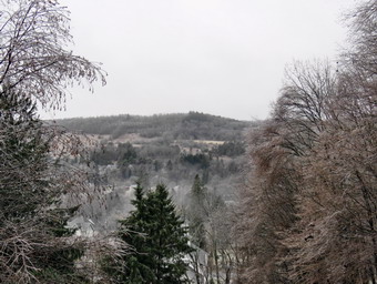
![]()
![]()
![]()
![]()
![]() On Saturday, January 2nd an overnight storm of sleet and freezing rain had left a coating on the trees so I decided to go across the street to Round Top to take some pictures. I had to get to the landfill first as the house was filled with Christmas wrappings and recyclables. I also wanted to make sure that people were driving carefully and that there was a reduced chance of an ambulance call. I started to get ready at about 9:00 AM and to my dismay the temperature had already risen to 35 degrees. I hurried to get ready and take my pictures before the ice melted. I put on my Mammut long-sleeved crew top with a long-sleeved baselayer since the temperature was cool. I decided to wear my Columbia Titanium insulated pants without a baselayer underneath. I wore my Salomon B52 winter boots which are supportive, surprisingly roomy and discontinued. I had recently put a pair of Protalus insoles in these shoes and found it improved the support for my feet immensely. The insoles in most hiking boots are a flimsy and flat piece of material. I grabbed my Leki external lock poles which I have been using since the spring since twist locks have proved unreliable. I also donned my Mammut hoody which was enough zippers to dump heat when needed. I put on a fleecy orange hat and wore a light pair of gloves. Sheila kept me in sight as I got ready to go making sure she would not be forgotten. I took my pack with me as it is the easiest way to carry my camera. We stepped out of the house at 9:30 AM. I put on my Kahtoola Microspikes as I expected the hill and the trails to be slippery. I grabbed Sheila's leash from the car and put it on her to safely cross the street. We walked up the driveway which was very icy and made my glad I had put on my spikes. We crossed the street and walked across the field by the church so the spikes would not become dull on the pavement. We began the ascent of the steepest hill behind the church and I found there was only a thin layer of ice that was already breaking up. I walked beside the pavement on the grass to prevent the spikes from becoming useless. The hill is short but gets the circulation pumping and is the steepest and longest climb on the "trail." I let Sheila off her leash so that I could use my poles to get up the hill. Sheila immediately began to bound up the hill with me following close behind. We stopped in the middle of the hill so that I could take pictures toward the "Flats" to the southeast. It was already clear that the ice was melting off the trees which was a big disappointment. Underneath the trees it was like walking in the rain except some of the "rain" was hard pieces of ice! The cemetery was covered in ice and all the trees on the surrounding hills were ice clad. When we got to the top of the hill, we stopped to look around at the hills around town. I took some more pictures across the valley to "Beer Mountain" and some to the north and west. We started on the trail by turning left at the trailhead. There were some tracks on the trails but I could not tell whether they were from today or the day before.
On Saturday, January 2nd an overnight storm of sleet and freezing rain had left a coating on the trees so I decided to go across the street to Round Top to take some pictures. I had to get to the landfill first as the house was filled with Christmas wrappings and recyclables. I also wanted to make sure that people were driving carefully and that there was a reduced chance of an ambulance call. I started to get ready at about 9:00 AM and to my dismay the temperature had already risen to 35 degrees. I hurried to get ready and take my pictures before the ice melted. I put on my Mammut long-sleeved crew top with a long-sleeved baselayer since the temperature was cool. I decided to wear my Columbia Titanium insulated pants without a baselayer underneath. I wore my Salomon B52 winter boots which are supportive, surprisingly roomy and discontinued. I had recently put a pair of Protalus insoles in these shoes and found it improved the support for my feet immensely. The insoles in most hiking boots are a flimsy and flat piece of material. I grabbed my Leki external lock poles which I have been using since the spring since twist locks have proved unreliable. I also donned my Mammut hoody which was enough zippers to dump heat when needed. I put on a fleecy orange hat and wore a light pair of gloves. Sheila kept me in sight as I got ready to go making sure she would not be forgotten. I took my pack with me as it is the easiest way to carry my camera. We stepped out of the house at 9:30 AM. I put on my Kahtoola Microspikes as I expected the hill and the trails to be slippery. I grabbed Sheila's leash from the car and put it on her to safely cross the street. We walked up the driveway which was very icy and made my glad I had put on my spikes. We crossed the street and walked across the field by the church so the spikes would not become dull on the pavement. We began the ascent of the steepest hill behind the church and I found there was only a thin layer of ice that was already breaking up. I walked beside the pavement on the grass to prevent the spikes from becoming useless. The hill is short but gets the circulation pumping and is the steepest and longest climb on the "trail." I let Sheila off her leash so that I could use my poles to get up the hill. Sheila immediately began to bound up the hill with me following close behind. We stopped in the middle of the hill so that I could take pictures toward the "Flats" to the southeast. It was already clear that the ice was melting off the trees which was a big disappointment. Underneath the trees it was like walking in the rain except some of the "rain" was hard pieces of ice! The cemetery was covered in ice and all the trees on the surrounding hills were ice clad. When we got to the top of the hill, we stopped to look around at the hills around town. I took some more pictures across the valley to "Beer Mountain" and some to the north and west. We started on the trail by turning left at the trailhead. There were some tracks on the trails but I could not tell whether they were from today or the day before.
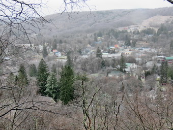 At the first trail junction, I continued straight ahead up the hill toward the viewpoint. Again, the climb up the hill was a little tiring as there was enough icy to make me slip and slide. At the viewpoint, we headed very carefully to the left to walk out to the overhanging rock shelf that forms the lookout. The snow was all gone and the rocks were covered in ice. Even Sheila slipped a little and I had to call her back since she likes to go right to the edge of the lookout. I took pictures of town and the school. I also took some shots of the hills around town. We walked back out to the main trail and followed the yellow trail as it turned right and headed up the gentle hill through the hardwood forest with trees encased in ice. There was no wind and everything was very still except for the ice melt off the trees and pelting us. At the first trail junction with the blue trail, turned right and followed the yellow trail along the base of Round Top. I usually take some pictures here but most of the ice had already melted and I just wanted to finish what was becoming a disappointing hike. This section was easier, even though there was ice because it is mostly flat. At the next junction I had to make a decision whether we would just do a small loop or go for the figure 8. I decided we would do the figure 8 so we turned left and started up the hill to the summit. We bypassed the white crossover trail and continued up and over the summit. When we started down the other side, I decided we would skip the new switchback on the blue trail and just continue down the hill. I was able to get a pretty good grip with the spikes and my poles but the trail was very icy especially on the steepest part! At the bottom of the hill we turned left on the yellow trail, walked along the base of Round Top and then turned right to walk down to the woods road. The ice continued to melt off the trees and I was getting wetter than some hikes I have taken in the rain. We walked the woods road out to the first trail junction. I decided I was wet enough and we turned left to walk out to the trailhead. We turned right and walked down the hill. I put Sheila on her leash in the church parking lot and we crossed the street to our driveway. We were home by 10:15 AM after hiking a mile in 45 minutes!
![]()
![]()
![]()
![]() On Thursday, December 31st I decided to get out and hike despite the freezing mist in the air. My choice was to go across the street and hike the trails that I helped to create and maintain on Round Topan. My son-in-law, Brad, agreed to go with me and Sheila seemed very happy that we would be going out. At 1:15 PM, we started to get ready with the temperature hanging at 33 degrees and overcast skies with some light freezing mist still hanging around. I put on my Mammut long-sleeved crew top with a long-sleeved baselayer since the temperature was cool. I decided to wear my Columbia Titanium insulated pants without a baselayer underneath. I wore my Salomon B52 winter boots which are supportive, surprisingly roomy and discontinued. I had recently put a pair of Protalus insoles in these shoes and was anxious to see how they performed. The insoles in most hiking boots are a flimsy and flat piece of material. I did not expect much snow although the possibility of mud was on my mind. I grabbed my Leki external lock poles which I have been using since the spring since twist locks have proved unreliable. I also donned my Mammut hoody which was enough zippers to dump heat when needed. I put on a fleecy orange hat and wore a light pair of gloves. We stepped out of the house at 1:45 PM. We had decided to put on spikes as we did not know how much ice we would find on the trails. I grabbed Sheila's leash from the car and put it on her to safely cross the street. We walked up the driveway and crossed the street. Since we had our spikes on, we walked across the field next to the church so we did not dull the spikes OM the road. When we stepped onto the parking lot, there was a layer of ice and I was glad we had the spikes. We began the ascent of the steepest hill behind the church that, surprisingly, did not have much ice. We both walked beside the pavement on the frozen grass. The hill is short but gets the circulation pumping and is the steepest and longest climb on the "trail." Sheila always helps me up the hill by giving me a good pull in her leash living up to the husky in her blood. When we got to the top of the hill, we stopped to look around at the hills around town. We started on the trail by turning left at the trailhead. There were some boot tracks on the trails but I could not tell whether they were from earlier in the day or from days before.
On Thursday, December 31st I decided to get out and hike despite the freezing mist in the air. My choice was to go across the street and hike the trails that I helped to create and maintain on Round Topan. My son-in-law, Brad, agreed to go with me and Sheila seemed very happy that we would be going out. At 1:15 PM, we started to get ready with the temperature hanging at 33 degrees and overcast skies with some light freezing mist still hanging around. I put on my Mammut long-sleeved crew top with a long-sleeved baselayer since the temperature was cool. I decided to wear my Columbia Titanium insulated pants without a baselayer underneath. I wore my Salomon B52 winter boots which are supportive, surprisingly roomy and discontinued. I had recently put a pair of Protalus insoles in these shoes and was anxious to see how they performed. The insoles in most hiking boots are a flimsy and flat piece of material. I did not expect much snow although the possibility of mud was on my mind. I grabbed my Leki external lock poles which I have been using since the spring since twist locks have proved unreliable. I also donned my Mammut hoody which was enough zippers to dump heat when needed. I put on a fleecy orange hat and wore a light pair of gloves. We stepped out of the house at 1:45 PM. We had decided to put on spikes as we did not know how much ice we would find on the trails. I grabbed Sheila's leash from the car and put it on her to safely cross the street. We walked up the driveway and crossed the street. Since we had our spikes on, we walked across the field next to the church so we did not dull the spikes OM the road. When we stepped onto the parking lot, there was a layer of ice and I was glad we had the spikes. We began the ascent of the steepest hill behind the church that, surprisingly, did not have much ice. We both walked beside the pavement on the frozen grass. The hill is short but gets the circulation pumping and is the steepest and longest climb on the "trail." Sheila always helps me up the hill by giving me a good pull in her leash living up to the husky in her blood. When we got to the top of the hill, we stopped to look around at the hills around town. We started on the trail by turning left at the trailhead. There were some boot tracks on the trails but I could not tell whether they were from earlier in the day or from days before.
At the first trail junction, we followed Sheila as she turned right on the woods road which is the shallower approach to the trail system. The trail had a light coating of icy snow which was slippery but did not really require spikes. We continued to follow the yellow trail toward the first junction. The snow was slippery but with the spikes we were able to manage without too much of a problem. At the junction, we turned left and followed it to the next trail junction. Along the way we picked up or removed many small branches and dragged several large ones off the trail. At the second junction with the blue trail, we turned right and started up the steep blue trail that leads over the summit of Round Top. Just before the steepest section we turned right on the switchback trail now marked with blue paint blazes. We continued to follow these blazes as they made a sharp right turn and headed back to the main blue trail. We turned right on the blue trail and continued up the blue trail. Within a few feet, we turned right on the white crossover trail and followed it to the end where it intersected the hue trail on the other side of Round Top. We turned right and walked downhill to the yellow trail. We turned right on the yellow trail and walked along the base of Round Top. This time we turned left at the junction with the blue trail and walked down to the lookout. The view from the lookout was ordinary so we continued the hike. We followed the yellow trail as it turned left and descended the hill to the first trail junction. We immediately turned around and walked back up the hill to the lookout and followed the yellow trail as it turned right. We followed the trail as it made a gentle ascent to the junction with the blue trail. We continued to follow the yellow trail by turning right and following along the base of Round Top. At the second junction with the blue trail, we turned left and started the ascent of the hill. When the white crossover trail came up and the left, we continued straight ahead on the blue trail and passed over the summit of Round Top. We continued downhill on the blue trail ignoring the crossover trail and the switchback in the blue trail. Coming down this steeper section was definitely tricky and would have been difficult without spokes. We finished the walk downhill and at the yellow trail we turned left. We walked back along the base of Round Top and turned right at the next junction. We walked down to the woods road that took us back to the first trail junction. We turned left and walked out to the trailhead where I out Sheila on her leash. We walked down the steep hill and across the field by the church to our driveway. We were back at the house at 3:00 PM having walked almost 3 miles in an hour and 15 minutes.
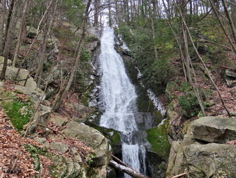
![]() On Tuesday, December 29th Cindy and I had visited Vernooy Kill Falls from the Upper Cherrytown Road parking area. I decided to see if I could find Buttermilk Falls in Spring Glen as I had never been there. At one time the falls was located on private property but it is now part of the Shawangunk Ridge State Forest. The falls comes down from the ridge and flows over the rocks before cascading into a pool. The base of the falls "hides" the opening to the Horseshoe Mine which was an exploratory lead mine. Almost no history of the mine can be found. It may have belonged to the North American Coal and Iron Company which had other mines in the area. These mines were active between 1838 and 1850. I drove back out to Route 209 and turned right to head back toward Evansville. As we passed through Evansville, Cindy asked that we stop at MacDonald's to get something to eat. The stop was short and we were soon on our way. From the intersection of Routes 209 and 52 in Evansville, I drove south on Route 209 for 4.6 miles to Mountain Road. I turned left and immediately left again on Lewis Road. Lewis Road is a dead end. I drove passed the Spring Glen Campgrounds and after .8 miles came to a stream passing under a small bridge on the left side of the road. Contrary to some reports, I could see a waterfall set back from the road. I pulled over on the left side of the road. We finished eating our lunch and then got out of the car to walk to the falls. I took only my camera rather than the entire pack. I took a few pictures of the stream as it passes beneath the small bridge. We walked up and incline to the O&W rail Trail. Turning left here and walking about 4 miles north on the rail trail leads back to the old Nevelle Hotel near Ellenville. We continued across the rail trail following an old road and the stream to the waterfall. The waterfall was beautiful with the water falling down over the rocks and then emptying into the pool at the bottom. The opening to the mine was clearly visible. I got busy taking pictures as the skies were cloudy over again and snow was beginning to fall! When I was done, we walked back to the car. I drove to the end of Lewis Road to turn around. As I was turning around, I saw a stone structure which proved to be part of the D&H Canal. I stopped the car and got out to take some pictures. I returned to the car and drove out Route 209 to Wurtsboro. Along the way were numerous signs for the D&H Canal Linear Park and I though I might return at another time to check it out.
On Tuesday, December 29th Cindy and I had visited Vernooy Kill Falls from the Upper Cherrytown Road parking area. I decided to see if I could find Buttermilk Falls in Spring Glen as I had never been there. At one time the falls was located on private property but it is now part of the Shawangunk Ridge State Forest. The falls comes down from the ridge and flows over the rocks before cascading into a pool. The base of the falls "hides" the opening to the Horseshoe Mine which was an exploratory lead mine. Almost no history of the mine can be found. It may have belonged to the North American Coal and Iron Company which had other mines in the area. These mines were active between 1838 and 1850. I drove back out to Route 209 and turned right to head back toward Evansville. As we passed through Evansville, Cindy asked that we stop at MacDonald's to get something to eat. The stop was short and we were soon on our way. From the intersection of Routes 209 and 52 in Evansville, I drove south on Route 209 for 4.6 miles to Mountain Road. I turned left and immediately left again on Lewis Road. Lewis Road is a dead end. I drove passed the Spring Glen Campgrounds and after .8 miles came to a stream passing under a small bridge on the left side of the road. Contrary to some reports, I could see a waterfall set back from the road. I pulled over on the left side of the road. We finished eating our lunch and then got out of the car to walk to the falls. I took only my camera rather than the entire pack. I took a few pictures of the stream as it passes beneath the small bridge. We walked up and incline to the O&W rail Trail. Turning left here and walking about 4 miles north on the rail trail leads back to the old Nevelle Hotel near Ellenville. We continued across the rail trail following an old road and the stream to the waterfall. The waterfall was beautiful with the water falling down over the rocks and then emptying into the pool at the bottom. The opening to the mine was clearly visible. I got busy taking pictures as the skies were cloudy over again and snow was beginning to fall! When I was done, we walked back to the car. I drove to the end of Lewis Road to turn around. As I was turning around, I saw a stone structure which proved to be part of the D&H Canal. I stopped the car and got out to take some pictures. I returned to the car and drove out Route 209 to Wurtsboro. Along the way were numerous signs for the D&H Canal Linear Park and I though I might return at another time to check it out.
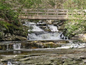
![]()
![]()
![]()
![]()
![]() On Tuesday, December 29th I wanted to visit some waterfalls in the Ellenville area including Vernooy Kill Falls near Kerhonksen, Buttermilk Falls in Spring Glen. And Hanging Rock Falls in Ulster Heights. The first two are in state forest and the third is on private property but the landowner allows public access. I asked Cindy if she wanted to go and she agreed. When we started to get ready at 8:45 AM the temperature was 26 degrees and the wind was blowing. On the bright side the sun was shining and the skies were blue with white, puffy clouds. Sheila was well-behaved but would not let us out of her sight. I put on my Mammut long-sleeved crew top with a long-sleeved baselayer since the temperature was cool. I decided to wear my Columbia Titanium insulated pants with a light pair of tights underneath. I wore my Salomon B52 winter boots which are supportive, surprisingly roomy and discontinued. I had recently put a pair of Protalus insoles in these shoes and was anxious to see how they performed. The insoles in most hiking boots are a flimsy and flat piece of material. I did not expect much snow although the possibility of mud was on my mind. I grabbed my Leki external lock poles which I have been using since the spring since twist locks have proved unreliable. I also donned my Mammut hoody which was enough zippers to dump heat when needed. I put on a fleecy orange hat and wore a light pair of gloves. At the last minutes, I put on my OR Crocodile gaiters to deal with the mud which I was sure we would find. We got out gear and Sheila in my car and left Livingston Manor at 9:15 AM. The recent rains had caused widespread flooding and the destruction of some roads so I was ready to change plans if we ran into nay questionable conditions. I drove east on State Route 17 to Liberty and then got on Route 55 headed toward Ellenville. I drove through Loch Sheldrake and then Woodbourne. In Ellenville in turned left on Route 209 and drove through Kerhonksen. Just outside of town I drove up a hill and turned left on Samsonville Road. After 1.3 miles, I turned left on Cherrytown Road. I drove 3.5 miles and took the left onto Upper Cherrytown Road. In about 3.0 miles I saw the parking area on the right and pulled in at 10:15 AM. There were only two other cars in the lot. I set my GPS and we walked across the road to begin our hike at 10:20 AM with the temperature at 33 degrees.
On Tuesday, December 29th I wanted to visit some waterfalls in the Ellenville area including Vernooy Kill Falls near Kerhonksen, Buttermilk Falls in Spring Glen. And Hanging Rock Falls in Ulster Heights. The first two are in state forest and the third is on private property but the landowner allows public access. I asked Cindy if she wanted to go and she agreed. When we started to get ready at 8:45 AM the temperature was 26 degrees and the wind was blowing. On the bright side the sun was shining and the skies were blue with white, puffy clouds. Sheila was well-behaved but would not let us out of her sight. I put on my Mammut long-sleeved crew top with a long-sleeved baselayer since the temperature was cool. I decided to wear my Columbia Titanium insulated pants with a light pair of tights underneath. I wore my Salomon B52 winter boots which are supportive, surprisingly roomy and discontinued. I had recently put a pair of Protalus insoles in these shoes and was anxious to see how they performed. The insoles in most hiking boots are a flimsy and flat piece of material. I did not expect much snow although the possibility of mud was on my mind. I grabbed my Leki external lock poles which I have been using since the spring since twist locks have proved unreliable. I also donned my Mammut hoody which was enough zippers to dump heat when needed. I put on a fleecy orange hat and wore a light pair of gloves. At the last minutes, I put on my OR Crocodile gaiters to deal with the mud which I was sure we would find. We got out gear and Sheila in my car and left Livingston Manor at 9:15 AM. The recent rains had caused widespread flooding and the destruction of some roads so I was ready to change plans if we ran into nay questionable conditions. I drove east on State Route 17 to Liberty and then got on Route 55 headed toward Ellenville. I drove through Loch Sheldrake and then Woodbourne. In Ellenville in turned left on Route 209 and drove through Kerhonksen. Just outside of town I drove up a hill and turned left on Samsonville Road. After 1.3 miles, I turned left on Cherrytown Road. I drove 3.5 miles and took the left onto Upper Cherrytown Road. In about 3.0 miles I saw the parking area on the right and pulled in at 10:15 AM. There were only two other cars in the lot. I set my GPS and we walked across the road to begin our hike at 10:20 AM with the temperature at 33 degrees.
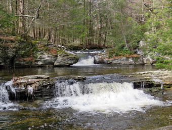 Almost immediately we met a hiker coming out of the trail. We said "Hello" to him and he greeted us as we headed in different directions. The trail is a wide woods road almost all the way to the falls. It is marked as a snowmobile trail, a hiking trail and the Long Path. The problem is that the markings are very few and far between. In fact, the ONLY blaze I saw for the Long Path was the one at the beginning of the trail just off the road. I had promised Cindy a relatively flat hike but I had not been to Vernooy Kill Falls in 9 years and it was much hillier than I remembered! I try to stay a way from the area in the warmer seasons as there are usually some rattlesnakes in the area. In about a mile it gains 550 feet which is a 10% grade. This is by no means excessive and at no time is the trail steep but it is a good workout. A good part of the trail is covered in loose rock which always makes the hiking more difficult. On this day there was ice, mud, frozen mud and some open water. A short way into the hike we had to cross a small stream swollen by the recent rains. We made it across but the footing was tricky. As we began to start the ascent, I looked back to see a dog coming up the trail behind us with no owner in sight. I called Sheila over to me to put her on her leash and found I had left it in the car. The dog retreated but then the owner and her other dog appeared. The owner said "Hi" but did not seem to realize it would be courteous to put her dogs on a leash or at least control them. We let her pass and then continued our hike. In a short distance, two young men came up behind us moving at a good pace and we greeted each other as they passed us. We followed the trail around a turn and her a horrendous noise coming from up ahead on the trail. It sounded as if a dog was attacking someone or being attacked. We could see a solo hiker coming down the trail carrying a small dog that was making the noise. The hiker passed us mumbling an apology and we continued in relative silence. We crossed a bridge over a substantial stream and I stopped to take a few shots before continuing. After about a mile the trail leveled hitting the highest point at about 1.3 miles. It was nice to hit level ground but now the trail was even wetter and muddier than before except for the areas of ice. From the high point the trail drops slightly to the falls at 1.7 miles. The stream crossing near the falls was easy due to some stepping stones.
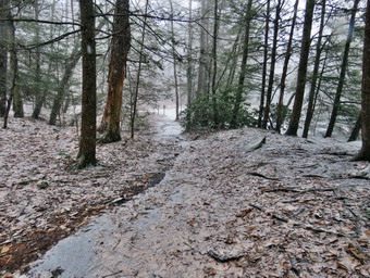 We arrived at the falls around 11:20 AM and found a large volume of water roaring over the falls and under the bridge. By the time we reached the falls the skies were still sunny but starting to cloud up some. I dropped my pack and poles by the register box and grabbed my camera. I stood on the bridge to take shots of the falls upstream. After taking some shots, I headed downstream from the bridge to stand on some rocks to take pictures of the bridge and the falls beneath it. The rocks were wet and ice which made them slippery so I was cautious of where I stepped. I also took some shots of the ruins of the mill which once operated on the power of the water in the stream. After returning to the bridge, we walked upstream along a well-defined path. There were several side paths down to the stream and I stopped at each to take pictures of the individual falls and rapids along the way. There was a lot of interesting foam on the water and quite a few icicles and ice along the opposite shore. As I was taking pictures a few snowflakes began to fall and this eventually turned into snow squall that quickly covered the ground. I took a few more pictures of the trail and the falls with the snow coming down. As we got ready to leave, Cindy decided to put on her spikes but I elected not to do so. At about 11:45 AM we started back toward the car by crossing the small stream on the stepping stones and then climbing the small hill. We negotiated the icy sections of the trail with Cindy and her spikes having the advantage. As we approached the wettest and muddiest section of the trail, I could see two young women trying to get their dog across this area. They explained that the dog did not like water! We wished them well and allowed them to pass and then continued our hike. The snow had stopped but started in again perhaps even harder than before. We met one more group coming up the hill and we walked off the trail to allow them to pass. The snow stopped and we made good time back to the car with only a slight pause crossing the stream. We were back in the parking area at 12:40 PM after hiking 3.4 miles in 2 hours and 20 minutes with 35 minutes of stopped time. The elevation gain was only 680 feet. I decided I wanted to check out Buttermilk Falls in Spring Glen and visit Hanging Rock Falls another day.
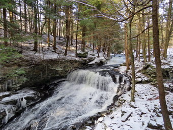
![]() On Sunday, December 27th we had visited Angel Falls on Sholam Road in Yagerville and Buttermilk Falls on the Peekamoose Road. I decided to return home by way of the back roads to check their condition and to visit Mongaup Falls if I wanted. I drove back down the Peekamoose Road into Sundown. I continued toward the Rondout Reservoir and turned right in Sugarloaf Road. I took Sugarloaf Road and the Red Hill Road over to the Denning Road. I turned left to drive through Claryville and right on Route 47 just south of Claryville. I continued on the road toward the Frost Valley YMCA Camp as OI wanted to see how the road improvements along the winding road had held up to the Neversink River swollen by the recent rains. I was again surprised to see that the Neversink was higher than normal but not raging. All of the improvements seemed to be holding up to the increased volume. I turned around and drove back toward Claryville but turned right on Pole Road. As I drove up the hill and along the road, it was obvious that the Town of Neversink did not think this road was very important. The road was very icy and there was almost no sand or salt. Pole Road turned to Willowemoc Road and the conditions improved slightly. In DeBruce, I turned right on Mongaup Pond Road and followed it north until the road split. Just before the split a pickup truck was parked on the side of the road and a man with hiking poles was looking down the bank toward the stream. I assumed he was looking for the falls. At the split in the road A HSEG crew was doing some work but they let me pass to head to the right and park in the small lot on the right.
On Sunday, December 27th we had visited Angel Falls on Sholam Road in Yagerville and Buttermilk Falls on the Peekamoose Road. I decided to return home by way of the back roads to check their condition and to visit Mongaup Falls if I wanted. I drove back down the Peekamoose Road into Sundown. I continued toward the Rondout Reservoir and turned right in Sugarloaf Road. I took Sugarloaf Road and the Red Hill Road over to the Denning Road. I turned left to drive through Claryville and right on Route 47 just south of Claryville. I continued on the road toward the Frost Valley YMCA Camp as OI wanted to see how the road improvements along the winding road had held up to the Neversink River swollen by the recent rains. I was again surprised to see that the Neversink was higher than normal but not raging. All of the improvements seemed to be holding up to the increased volume. I turned around and drove back toward Claryville but turned right on Pole Road. As I drove up the hill and along the road, it was obvious that the Town of Neversink did not think this road was very important. The road was very icy and there was almost no sand or salt. Pole Road turned to Willowemoc Road and the conditions improved slightly. In DeBruce, I turned right on Mongaup Pond Road and followed it north until the road split. Just before the split a pickup truck was parked on the side of the road and a man with hiking poles was looking down the bank toward the stream. I assumed he was looking for the falls. At the split in the road A HSEG crew was doing some work but they let me pass to head to the right and park in the small lot on the right.
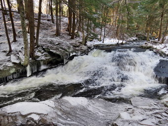 The crew left and Sheila and I walked along the road back to the intersection. Here we turned left down what used to be Hunter Road. The road is now eroded and had a little more than an inch of snow on it. We crossed the creek on what is left of a culvert which acted as a bridge. We turned right and walked along the edge of the stream to the two-tiered falls. The stream was roaring and an exceptional volume of water was going over the falls. I decided to photograph the lower and larger drop first. I put My pack down and got out my camera. I looked to see if I could climb down the rocks to the base of the falls as I usually do but that was out of the question. The rocks were either covered with water from the falls or covered in ice because of the spray. I decided to walk along the rim of the gorge cut by the stream to a point downstream and more in from of the falls. This proved to be an adventure as the rim was icy and the ice was cored with a layer of snow! I OT what I though might be some good shots and returned to my pack without falling. Sheila alerted and I could see the man that had been along the road and a woman walking toward us. I told Shiela to stay with me which she did. I turned my attention to the upper falls. I could not get down to the for a long time rocks by the stream bed so I settled for another viewpoint that was almost as good and much safer. I took pictures of the upper falls itself and some upstream from the falls. I also took some pictures downstream showing the gorge and some impressive icicles that had formed. Eventually, I had photographed everything that I could so I returned to my pack. I put away the camera, shouldered the pack and we walked back to the car. I was pleased with our adventures and the pictures I had taken.
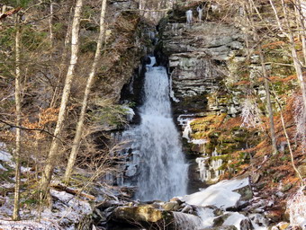
![]() On Sunday, December 27th we visited Angel Falls on Sholam Road in Yagerville. When we had finished there, I decided to head to Peekamoose Road to visit Buttermilk Falls. I drove up Sholam Road and turned right on Yagerville Road to head toward Sundown. Where the road split in Sundown, I turned right on Peekamoose Road. I drove 4.3 miles to the parking are for Buttermilk Falls on the left about a mile passed the parking area for Peekamoose Mountain and the Blue Hole. The Peekamoose parking area had three cars parked. The previous parking areas had one car parked in each. When I parked the car by Buttermilk Falls there was only one other car in the lot. The car was a small, sporty convertible with the top down! I left Sheila in the car and walked to the bridge over the stream to take some shots. I was surprised that the volume of the falls was only slightly greater than on most days. I took a few pictures from the road but decided not to walk to the stream bed. I returned to the car and decided not to visit any of the other falls as finding a place to park is a problem. I did decide to go home by way of the back roads so that I could stop at Mongaup Falls if I wanted.
On Sunday, December 27th we visited Angel Falls on Sholam Road in Yagerville. When we had finished there, I decided to head to Peekamoose Road to visit Buttermilk Falls. I drove up Sholam Road and turned right on Yagerville Road to head toward Sundown. Where the road split in Sundown, I turned right on Peekamoose Road. I drove 4.3 miles to the parking are for Buttermilk Falls on the left about a mile passed the parking area for Peekamoose Mountain and the Blue Hole. The Peekamoose parking area had three cars parked. The previous parking areas had one car parked in each. When I parked the car by Buttermilk Falls there was only one other car in the lot. The car was a small, sporty convertible with the top down! I left Sheila in the car and walked to the bridge over the stream to take some shots. I was surprised that the volume of the falls was only slightly greater than on most days. I took a few pictures from the road but decided not to walk to the stream bed. I returned to the car and decided not to visit any of the other falls as finding a place to park is a problem. I did decide to go home by way of the back roads so that I could stop at Mongaup Falls if I wanted.
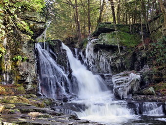
![]()
![]() On Sunday, December 27thI wanted to get out of the house after four days without hiking. The Christmas holiday, numerous ambulance calls and rainy weather had conspired to keep us inside or at least away from hiking! I wanted to go see some waterfalls as I knew they should have a high volume after the recent rains. I decided to start with Angel Falls on Sholam Road in Yagerville to hike to the upper and lower falls. By the time I started to get ready at 11:30 AM the temperature was 26 degrees. Sheila was frantic as she had not been out in several days and was running around the house barking. I put on my Mammut long-sleeved crew top with a long-sleeved baselayer since the temperature was cool. I decided to wear my Columbia Titanium insulated pants but decided against tights underneath. I wore my Keen Targhee II boots which are supportive, surprisingly roomy and discontinued. I did not expect much snow although the possibility of mud was on my mind. I grabbed my Leki external lock poles which I have been using lately since twist locks have proved unreliable. I also donned my Mammut hoody which was enough zippers to dump heat when needed. I put on a fleecy orange hat and wore a light pair of gloves. At the last minutes, I put on my OR Crocodile gaiters to deal with the mud which I was sure I would find. I got my gear and Sheila in my car and left Livingston Manor at around noon. The recent rains had caused widespread flooding and the destruction of some roads so I was ready to change plans if I ran into nay questionable conditions. I drove east on State Route 17 to Liberty and then got on Route 55 to Grahamsville. I turned left onto Route 55A just after the Tri-Valley school and toward Sundown. I followed RT 55A as it turned right and crossed the Rondout Reservoir. I drove to Yagerville Road where I turned left and drove another 1.2 miles to Sholam Road. Here I turned right and drove to where the road dead ends. I parked in the small lot that has been created for hikers at 12:40 PM and got ready to hike. We started off almost immediately down what used to be Sholam Road. The road is very eroded but makes a good trail which is why I was surprised to see the sign. The sign posted by the DEP stated that the road was seasonal use only and was not maintained. I found this funny since no one would think that this "road" was fit for any vehicle except for a four wheeler! I was pleased that I could hear a roar coming from the falls apparently indicating a good volume of water. We walked along the road which had some patches of snow and ice and one wet area. I was surprised that the rest of the ground was pretty hard and there wasn't much mud. We passed the top of the falls and continued upstream a little farther. There was a good volume of water so I walked over to the side of the stream and out onto a flat rock. As I looked at the stream, I could see that a bridge used to cross at this point. I wondered why I had never discovered this before in my many trips. There was also a small waterfall at this point so I took some pictures of the falls and some upstream and downstream. I considered walking a little more along the stream or on what was left of the road but instead turned around and walked back to the top of the falls. At the top of the falls I turned left on a path that parallels Trout Creek. I looked down at the falls and saw that it was higher than I had seen it in some time. Trout Creek is rather long extending around 5 miles from Balsam Swamp. Over its course it picks up a few tributaries.
On Sunday, December 27thI wanted to get out of the house after four days without hiking. The Christmas holiday, numerous ambulance calls and rainy weather had conspired to keep us inside or at least away from hiking! I wanted to go see some waterfalls as I knew they should have a high volume after the recent rains. I decided to start with Angel Falls on Sholam Road in Yagerville to hike to the upper and lower falls. By the time I started to get ready at 11:30 AM the temperature was 26 degrees. Sheila was frantic as she had not been out in several days and was running around the house barking. I put on my Mammut long-sleeved crew top with a long-sleeved baselayer since the temperature was cool. I decided to wear my Columbia Titanium insulated pants but decided against tights underneath. I wore my Keen Targhee II boots which are supportive, surprisingly roomy and discontinued. I did not expect much snow although the possibility of mud was on my mind. I grabbed my Leki external lock poles which I have been using lately since twist locks have proved unreliable. I also donned my Mammut hoody which was enough zippers to dump heat when needed. I put on a fleecy orange hat and wore a light pair of gloves. At the last minutes, I put on my OR Crocodile gaiters to deal with the mud which I was sure I would find. I got my gear and Sheila in my car and left Livingston Manor at around noon. The recent rains had caused widespread flooding and the destruction of some roads so I was ready to change plans if I ran into nay questionable conditions. I drove east on State Route 17 to Liberty and then got on Route 55 to Grahamsville. I turned left onto Route 55A just after the Tri-Valley school and toward Sundown. I followed RT 55A as it turned right and crossed the Rondout Reservoir. I drove to Yagerville Road where I turned left and drove another 1.2 miles to Sholam Road. Here I turned right and drove to where the road dead ends. I parked in the small lot that has been created for hikers at 12:40 PM and got ready to hike. We started off almost immediately down what used to be Sholam Road. The road is very eroded but makes a good trail which is why I was surprised to see the sign. The sign posted by the DEP stated that the road was seasonal use only and was not maintained. I found this funny since no one would think that this "road" was fit for any vehicle except for a four wheeler! I was pleased that I could hear a roar coming from the falls apparently indicating a good volume of water. We walked along the road which had some patches of snow and ice and one wet area. I was surprised that the rest of the ground was pretty hard and there wasn't much mud. We passed the top of the falls and continued upstream a little farther. There was a good volume of water so I walked over to the side of the stream and out onto a flat rock. As I looked at the stream, I could see that a bridge used to cross at this point. I wondered why I had never discovered this before in my many trips. There was also a small waterfall at this point so I took some pictures of the falls and some upstream and downstream. I considered walking a little more along the stream or on what was left of the road but instead turned around and walked back to the top of the falls. At the top of the falls I turned left on a path that parallels Trout Creek. I looked down at the falls and saw that it was higher than I had seen it in some time. Trout Creek is rather long extending around 5 miles from Balsam Swamp. Over its course it picks up a few tributaries.
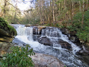 Sheila and I walked along the path which had a few wet and muddy spots but was nothing like I had expected. I was looking for a way down to the stream bed and found a steep path heading to the left and down to the creek bed. I started down the path but immediately ran into ice. Fortunately, I was able to get around the ice and work my way down to the edge of the stream right in front of the falls. Sheila was leading the way and we ended up at some rocks near the base of the falls. I could see some of the rocks were covered in a layer of ice but others appeared to be almost dry. I should have known better but I stepped ion one of the "dry" rocks and almost lost my balance! These rocks were covered with the frozen spray from the falls. Once I was safe, I contemplated putting on my microspikes but saw that I had a good view from where I was. I decided to play it safe and took my pictures including a video from where I was. I took shots of the falls and some downstream. To capture the volume and character of the falls, I shot a short video before packing up and heading back up to the main trail. Although the trail isn't really maintained, someone had cut a few of the trees that had been across the trail. We continued down the path heading toward the lower falls. The trail can be overgrown with weeds but was relatively clear as the cold weather had killed them off. I was happy that there was almost no broken glass around the area. We walked to the top of the falls and this time I stayed back from the flat rock shelf I normally use as it was covered in ice. We walked a little farther downstream where I found another vantage point just below the top of the falls and I took some more pictures of the falls. The spot I often use was too close to the water and covered in ice. When I was done at this spot, we headed down the path to the base of the falls where there are some old foundations. I took some pictures of the foundations from a slight elevation. With all the leaves off the trees the ruins stand out more prominently. I walked down to the creek bed and was able to get out onto some rocks which gave me a good view of the falls. This drop is not as high as the upper falls but is still pretty in its own way. After taking a few pictures. I carefully made my way back to my pack. I have always wanted to go to the other side if the stream as I have seen people there but I do not know how to get access. As we started back to the car, I noticed a large white pine with four or five intertwined trunks. I took a few shots of this before continuing up the hill. We worked our way up a steep path back to Sholam Road and back to the car. It was 1:20 PM and we had hiked only .9 miles in about one hour with 200 feet of elevation gain. I decided to drive to Buttermilk Falls on the Peekamoose Road to take some pictures and check out the road conditions.
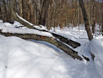
![]()
![]()
![]()
![]()
![]() On Wednesday, December 23, I had developed no specific plan to hike. I even though I might take the day off but knew the heavy rain in the forecast would ruin the hiking. An ambulance call in the middle of the night caused me to sleep in until about 10:00 AM. When I got up, I did some work around the house but then decided I needed to get out before the storm. I decided to go back to the Frick Pond area to remove three blowdowns; two on the Flynn Trail and one on the Big Rock Trail. One blowdown was near the parking area so I knew I could walk there with my tools and without snowshoes. My plan WA to remove that blowdown and then go back to the car, put on the snowshoes and exchange my ax for poles. I was pretty confident I could get the other two blowdowns with just a saw. The temperature was 33 degrees as I started to get ready just before noon. I knew I would get warm from hiking and working so I got dressed in a Mountain Hardwear 1/4 zip top which is buttery soft and did not out on a baselayer. I decided to wear my Columbia Titanium insulated pants to keep the chill away but decided I did not need a pair of tights underneath. I wore my Salomon B-52 insulated boots which have been discontinued but are my favorite boots for winter. I put on a pair of OR Crocodile gaiters as I did not know the depth of snow we would encounter. I grabbed the pair of Leki poles with external locks that I have been using lately. I put on a fleecy orange hat and a pair of light gloves. I also donned my Mammut hoody which blocks the wind and keeps me warm but has enough zippers to dump heat when needed. I decided to carry my microspikes in case they were needed. I opted to bring my Tubbs Alp Flex VRT snowshoes. The Boa binding on these uses a thin steel cable system and a ratchet which tightens it to give a custom fit and a secure binding. These snowshoes also have a televator to elevate the hiker's heel on ascents. This is a feature that you didn't know you needed until you try it and then it is hard to live without it! I put two plastic felling wedges in my pack along with my Silky Sugowaza fixed saw in its scabbard. This saw is amazing and I sometimes forget the size of some of the trees I have sliced through with it. I also brought along my Fiskars pack ax. I put my gear in the back of the car and Sheila in the back seat. We left Livingston Manor at about 12:10 PM and I drove out the DeBruce Road about 6 miles to Mongaup Road. I turned left and continued up the road to the point where it splits. I stayed left on Beech Mountain Road and drove to the parking areas on the left. I pulled into the smaller parking area just as another car also parked there. There were no cars in the larger lot. The temperature was 35 degrees but it seemed warmer. I got ready to head out on the Flynn Trail leaving the snowshoes and poles in the car and carrying my ax.
On Wednesday, December 23, I had developed no specific plan to hike. I even though I might take the day off but knew the heavy rain in the forecast would ruin the hiking. An ambulance call in the middle of the night caused me to sleep in until about 10:00 AM. When I got up, I did some work around the house but then decided I needed to get out before the storm. I decided to go back to the Frick Pond area to remove three blowdowns; two on the Flynn Trail and one on the Big Rock Trail. One blowdown was near the parking area so I knew I could walk there with my tools and without snowshoes. My plan WA to remove that blowdown and then go back to the car, put on the snowshoes and exchange my ax for poles. I was pretty confident I could get the other two blowdowns with just a saw. The temperature was 33 degrees as I started to get ready just before noon. I knew I would get warm from hiking and working so I got dressed in a Mountain Hardwear 1/4 zip top which is buttery soft and did not out on a baselayer. I decided to wear my Columbia Titanium insulated pants to keep the chill away but decided I did not need a pair of tights underneath. I wore my Salomon B-52 insulated boots which have been discontinued but are my favorite boots for winter. I put on a pair of OR Crocodile gaiters as I did not know the depth of snow we would encounter. I grabbed the pair of Leki poles with external locks that I have been using lately. I put on a fleecy orange hat and a pair of light gloves. I also donned my Mammut hoody which blocks the wind and keeps me warm but has enough zippers to dump heat when needed. I decided to carry my microspikes in case they were needed. I opted to bring my Tubbs Alp Flex VRT snowshoes. The Boa binding on these uses a thin steel cable system and a ratchet which tightens it to give a custom fit and a secure binding. These snowshoes also have a televator to elevate the hiker's heel on ascents. This is a feature that you didn't know you needed until you try it and then it is hard to live without it! I put two plastic felling wedges in my pack along with my Silky Sugowaza fixed saw in its scabbard. This saw is amazing and I sometimes forget the size of some of the trees I have sliced through with it. I also brought along my Fiskars pack ax. I put my gear in the back of the car and Sheila in the back seat. We left Livingston Manor at about 12:10 PM and I drove out the DeBruce Road about 6 miles to Mongaup Road. I turned left and continued up the road to the point where it splits. I stayed left on Beech Mountain Road and drove to the parking areas on the left. I pulled into the smaller parking area just as another car also parked there. There were no cars in the larger lot. The temperature was 35 degrees but it seemed warmer. I got ready to head out on the Flynn Trail leaving the snowshoes and poles in the car and carrying my ax.
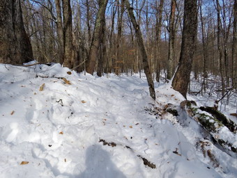 We walked across the road to get on the Flynn Trail. We passed the trail register walked the trail through the woods to the blowdown that was blocking the trail. I put my pack and ax down and took some pictures of the trees that lay across the trail. I developed a plan and used the ax to cut the first and smaller of the two tree on one side of the trail. I had hoped to simply flip the remaining part of the trunk off the trail. It was at this point I found out that the remaining portion was connected to a larger trunk and I would have to cut it again. Although the wood was largely frozen, it cut pretty easily. I finished my cut and then was able to pivot the section off the trail. I cut a few more smaller branches to get them out of the way and turned my attention to the other trunk. This trunk was longer and bigger in diameter. I used the ax to cut it away from the larger trunk but this produced a section that was a little two heavy for me to lift. I was able to use gravity to move the section to the side of the trail but had to cut it again with the saw to get it clear of the trail. I looked up to see a young woman coming toward us with her dog. She had a leash for the dog but apparently did not know how to use it. She was using poles but had no snowshoes. I pulled Sheila off the trail to allow her to pass. I asked her to walk beside the snowshoe track rather than ruin it with her boots. I looked at what I had done and was pleased. I took some pictures of the finished work and then picked up my tools and headed back to the car. I put the ax in the car and got out my poles and snowshoes. The lot now had four cars and another pulled in as I was getting ready. There were no cars in the larger lot and I wondered why people did not make use of both lots if only to socially distance. It was 1:15 PM when Sheila and I crossed the road and started back out on the Flynn Trail.
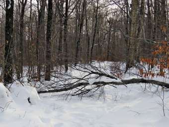 As soon as we turned right onto what was once Beech Mountain Road, I could feel how tired I was. My hips and lower back had dull aches and I was just tired overall. I pushed myself to continue but I found myself stopping frequently for brief rests. I noticed that the young woman had not been kind enough to do as I asked and was walking in the snowshoe track. I reasoned that it didn't matter too much as the rain that was coming would take away most of the snow but it was still annoying. At first, I thought I might turn around but I eventually developed a pace that I could live with. At 2:15 PM we were almost to the junction with the Big Rock Trail and arrived at the second blowdown. This one had more branches and much smaller trunk than the first one. I took some pictures and then started to remove branches. Some of the branches were buried in the snow and freeing them was harder than the cutting. Eventually, I was left with just the main trunks so I cut them and removed them from the trail. I took some pictures of the clear trail and then noticed Sheila by my pack. She seemed to be hiding behind it so I took some shots before packing up at 2:40 PM. It was a short walk to the junction with the Big Rock Trail where I planned to turn left and walk downhill on the packed snowmobile track. It was then that I saw the young woman and her dog returning from Hodge Pond. We made the left urn onto the Big Rock Trail quickly as I was afraid I would say something to her that I would regret.
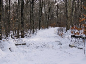 Walking down the Big Rock Trail was very enjoyable as it was packed by snowmobiles and one had recently passed, I did pick up a few rocks and threw them off the trail for everybody's benefit. By this time I was tired but going downhill helped. I had already decided that the remaining blowdown would have to wait for another day or be cleared by the snowmobile club. We descended the first two levels of the Big Rock Trail. As we started the third descent that old lead to Times Square, we cam to the third blowdown. It was 3:00 Pm and as I surveyed the mess I saw that these trunk were the largest yet. Despite this, I decided to take a crack at clearing what was blocking the trail. I took a few shots and then got to cutting and clearing smaller branches first. Once again, the cutting was fairly easy but pulling from under the snow was harder. I had to clear a few branches that were hanging overhead and some that were underfoot. After cutting and cleaning the branches, I turned my attention to the trunk. I cut them and flipped or pivoted them off the trail. I noticed that there was a second set of branches interfering with clear passage on the trail so I spent some more time getting rid of this second set. I stood back to look at my work and saw that one of the sections of trunk was too close to the edge of the trail. I dragged this section to the other side of the trail and pronounced my work for the day complete. I took some shots of the work I had done and then packed up to leave at 3:30 PM. We walked down the last descent to Times Square where there was some water and open areas. We stayed on the Big Rock Trail by walking straight across the junction. I was tired but Sheila seemed fresh as she ran up the trail and then back to me. We crossed the two small bridges over the inlet streams and then negotiated the wooden walkways. I was too interested in finishing to stop and take picture. At the junction with the Quick Lake Trail, we turned left and walked toward the bridge at the out let end of Frick Pond. We had to cross one very wet area and I wondered what this would look like after the rain. As we crossed the ridge, I took at look at the pond and decided there was nothing that was very interesting to photograph. We walked up the hill to Gravestone Junction and the followed the Quick Lake Trail to the register. At the register, we continued on the woods road back to the car. It was 4:15 PM when we arrived at the car and we were the last car in the lot. We had covered about 5 miles and removed 3 goo-sized blowdowns in 3 hours and 45 minutes with an 800 elevation gain. I drove home on DeBruce Road and encountered a turkey that felt it had the right-of-way. The turkey did not fare well but my car seemed to be unharmed.
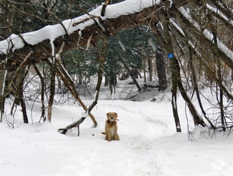
![]()
![]()
![]()
![]()
![]() On Tuesday, December 22nd, I was ready to get out for my first hike of the winter. I had hoped to hike on Monday on the very first day of the season but our new ambulance arrived. I met the representative of the dealer to accept the new rig and pointed out some issue. I spent the rest of the day stocking the ambulance and putting essential equipment on it.When I got up at 8:00 AM the temperature was in the high 20's and I knew it was supposed to rise some during the day. There were also some flurries or snow showers in` the forecast. The rising temperatures might make cause the snow to clump on the snowshoes but I knew it was better to try a hike rather than just write the day off. Although I have been there many times I decided to go to Frick Pond. I used to think that hiking a Frick Pond so frequently was boring but I now find it comforting. I know every trail and distance around Frick and Hodge Ponds and can easily add or remove trails to make a hike of any length. By 9:00 AM the temperature had risen to 30 degrees and I started to get ready to go. I got my gear together and decided to try to not overdress which I do frequently. I got dressed in my Mammut crew top with a light, long-sleeved baselayer. I decided to wear my Columbia Titanium insulated pants to keep the chill away but decided I did not need a pair of tights underneath. I wore my Salomon B-52 insulated boots which have been discontinued but are my favorite boots for winter. I put on a pair of OR Crocodile gaiters as I did not know the depth of snow we would encounter. I grabbed the pair of Leki poles with external locks that I have been using lately. I put on a fleecy orange hat and a pair of light gloves. Finally, I also donned my Mammut hoody which blocks the wind and keeps me warm but has enough zippers to dump heat when needed. I decided to carry my microspikes in case they were needed. I decided to wear my Tubbs Alp Flex VTR snowshoes. The Boa binding on these uses a thin steel cable system and a ratchet which tightens it to give a custom fit and a secure binding. These snowshoes also have a televator to elevate the hiker's heel on ascents. This is a feature that you didn't know you needed until you try it and then it is hard to live without it! I put my gear in the back of the car and Sheila in the back seat. We left Livingston Manor at 9:25 AM and I drove out the DeBruce Road about 6 miles to Mongaup Road and turned left. I continued up the road to the point where it splits and stayed left on Beech Mountain Road. It was a short drive to the parking areas on the left. Both parking area were empty as I pulled into the smaller lot. The temperature was 30 degrees under completely overcast skies and there was now light wind blowing. There was still snow everywhere and some ice on the road. I cheeked out the beginning of the Flynn Trail and found the snow packed with a pretty good track set. I put on my snowshoes, set my GPS and shouldered my pack as we crossed the road to start the hike at 9:45 AM.
On Tuesday, December 22nd, I was ready to get out for my first hike of the winter. I had hoped to hike on Monday on the very first day of the season but our new ambulance arrived. I met the representative of the dealer to accept the new rig and pointed out some issue. I spent the rest of the day stocking the ambulance and putting essential equipment on it.When I got up at 8:00 AM the temperature was in the high 20's and I knew it was supposed to rise some during the day. There were also some flurries or snow showers in` the forecast. The rising temperatures might make cause the snow to clump on the snowshoes but I knew it was better to try a hike rather than just write the day off. Although I have been there many times I decided to go to Frick Pond. I used to think that hiking a Frick Pond so frequently was boring but I now find it comforting. I know every trail and distance around Frick and Hodge Ponds and can easily add or remove trails to make a hike of any length. By 9:00 AM the temperature had risen to 30 degrees and I started to get ready to go. I got my gear together and decided to try to not overdress which I do frequently. I got dressed in my Mammut crew top with a light, long-sleeved baselayer. I decided to wear my Columbia Titanium insulated pants to keep the chill away but decided I did not need a pair of tights underneath. I wore my Salomon B-52 insulated boots which have been discontinued but are my favorite boots for winter. I put on a pair of OR Crocodile gaiters as I did not know the depth of snow we would encounter. I grabbed the pair of Leki poles with external locks that I have been using lately. I put on a fleecy orange hat and a pair of light gloves. Finally, I also donned my Mammut hoody which blocks the wind and keeps me warm but has enough zippers to dump heat when needed. I decided to carry my microspikes in case they were needed. I decided to wear my Tubbs Alp Flex VTR snowshoes. The Boa binding on these uses a thin steel cable system and a ratchet which tightens it to give a custom fit and a secure binding. These snowshoes also have a televator to elevate the hiker's heel on ascents. This is a feature that you didn't know you needed until you try it and then it is hard to live without it! I put my gear in the back of the car and Sheila in the back seat. We left Livingston Manor at 9:25 AM and I drove out the DeBruce Road about 6 miles to Mongaup Road and turned left. I continued up the road to the point where it splits and stayed left on Beech Mountain Road. It was a short drive to the parking areas on the left. Both parking area were empty as I pulled into the smaller lot. The temperature was 30 degrees under completely overcast skies and there was now light wind blowing. There was still snow everywhere and some ice on the road. I cheeked out the beginning of the Flynn Trail and found the snow packed with a pretty good track set. I put on my snowshoes, set my GPS and shouldered my pack as we crossed the road to start the hike at 9:45 AM.
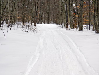 We had to climb over a low snow bank left by the plows to start out on the Flynn Trail. After that, the walk through the woods was relatively easy. Along the way we came to two trees that were lying across the trail. These trees had been hanging overt he trail for some time and I had wondered of they would ever fall. I had no tools to clad them and knew I would have to come back another day to clear them. When we turned right onto what once was Beech Mountain Road, there were two different snowshoe tracks. This is foolish as setting one track makes the most sense but people don't seem to have much common sense. Some people seemed to have worn bare boots which is their choice but I wish they would stay out of the snowshoe track. The warm weather the previous two days had softened and consolidated the snow so that in most placed there was a depth of only 6 to 8 inches. As we walked up the trail, the skies were still overcast and I beloved that we might get some precipitation. Despite the cool breeze. I began to warm up quickly. At one point I stopped to take a few pictures and open some of the zippers on my hoody. We continued up the hill passing the clearing on the right side of the trail just after 1 mile. The Flynn Trail dipped briefly before climbing the last .6 miles to the junction with the Big Rock Trail. We did encounter one small tree across the trail and we followed the snowshoe track thought the woods and around the tree, I was happy to see that some snowmobiles had come over from Mongaup Pond packing the Big Rock Trail. We turned left to descend the Big Rock Trail. I was happy to see that there were no snowmobile tracks headed toward Hodge Pond. Walking down the packed Big Rock Trail seemed very easy. Just after we started, I stopped or a minute to take some pictures of the trail. The Big Rock Trail has several spots where the trail levels some and bends to the right. These spots sometimes fool me into thinking we are near to Times Square when we are not. There was one tree across the trail and the snowmobiles had found another path through the woods and around the tree which we followed. On this day I was lost in my thoughts and the walk went quickly. At 11:25 PM we had hiked 2.85 miles and stood at Times Square where the Big Rock Trail and Logger's Loop cross. I decided that since I was feeling fresh and the trail was packed, we would turn right and hike the Logger's Loop to the Quick Lake Trail at Iron Wheel Junction.
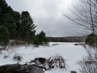 As we started out on the Logger's Loop, the trail was covered in ice with almost no snow. This did not last very long and soon we were again walking on the snow packed by snowmobiles. As we started up the hill, I could hear hard ice pellets hitting my jacket. The skies were very dark and I wondered how serious the storm would get. The trail heads northwest and gains about 200 feet in .8 miles where it turns southwest. Along the way I noticed the beauty of the high rocks and small cliffs on the right side of the trail. I also noticed that the ice pellets had stopped falling although the skies were still dark. From the highest point on the trail we began to descend slightly to Iron Wheel Junction at 4.15 miles. We turned left to follow the Quick Lake Trail toward Frick Pond. This part of the trail had a snowshoe track that I had set some days before and walking was a little more difficult. The skies darkened again and the ice pellets and snow began to fall in earnest! The trails had less snow here with water underneath which made the snow clump on the bottoms of the snowshoes. We walked downhill to the small stream in the woods and found it was still too high to cross on the trail. A short trip upstream helped us find a place to cross but I stumbled a little getting the bottoms of both feet wet. This further added to the clumping of the snow. We got back on the main trail and walked through the "spruce tunnel". This went quickly and we were soon at the junction with the Big Rock Trail. We stayed to the right on the Quick Lake Trail and walked to the bridge at the outlet of Frick Pond. I stopped for a few minutes to get some pictures. Each time I pass this way I seem to be attracted to the beauty of the scene. I took some pictures of Flynn's Point on Beech Mountain with the snow falling. I also took some more of the pond and the outlet. I picked up my pack and walked to the top of the hill where Sheila was waiting. We walked toward Gravestone Junction where we stayed to the right on the Quick Lake Trail. This part of the trail was completely-packed down since many people only walk out to the pond or do the loop around it. There were areas where there was bare rock and some areas of open water. We continued along the Quick Lake Trail passing the register box to walk the last few hundred feet to the car. It was 12:45 PM and we had hiked 5.5 miles in 3 hours with an elevation gain of 910 feet.