| Pick a Catskill 35 Peak: |
Southwest Hunter Peak
Southwest Hunter or Leavitt Peak was the last peak to qualify as one of the Catskill 25's. It is
far enough away from Hunter and high enough to be included in this category. It is usually climbed with
Hunter but can be done alone. As with any trailless peak it can be quite challenging. Recently a prominent path has "developed" on the northern side making this approach much easier. The direct assault from Diamond Notch is still the steepest and most difficult to navigate. There are
several different approaches and a couple of these have viable options for forming a loop.
| Trailhead Coordinates | |
|---|---|
| Name | Coordinates |
| Spruceton Road (first lot) | N42.1847 W74.2719 |
| Spruceton Road (second lot) | N42.1824 W74.2695 |
| Route 214 (Notch Lake) | N42.1595 W74.2034 |
| Becker Hollow | N42.1816 W74.1968 |
| Diamond Notch | N42.1498 W74.2647 |
| Quick Look - Herd Path from Notch Lake | ||||
|---|---|---|---|---|
| Difficulty | Round trip | Total climb | Location | Internet Maps |
| 6.3 mi. | 2100 ft. | N42.1625 W74.2439 | AllTrails | |
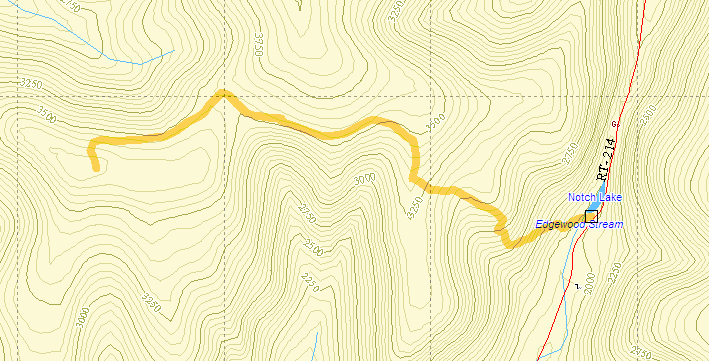
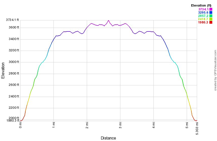
One approach is to park at the Devil's Tombstone State Campgrounds on Stony Clove Road and pay the seasonal parking fee. Find the red-blazed Devil's Path and hike 2.1 miles to the junction with the yellow-blazed Hunter Mountain Trail. Sections of this part of the Devil's Path rise sharply but others are relatively flat. At the junction continue straight ahead to the devil's Acre lean-to and spring. A short distance passed this is the remains of an old cog railway bed. Continue passed this point and watch for the path on the left that may be marked by a stone cairn. Leave the Devil's Path to the left and follow the path along the base of the Southwest Hunter ridge. After some time the path turns abruptly to the left and follows a steep route uphill directly to the canister. After signing in, retrace your steps back to the parking area.
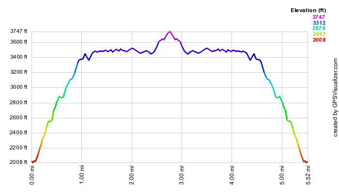
| Quick Look - Bushwhack from Notch Lake | ||||
|---|---|---|---|---|
| Difficulty | Round trip | Total climb | Location | Internet Maps |
| 6.3 mi. | 2000 ft. | N42.1625 W74.2439 | AllTrails | |
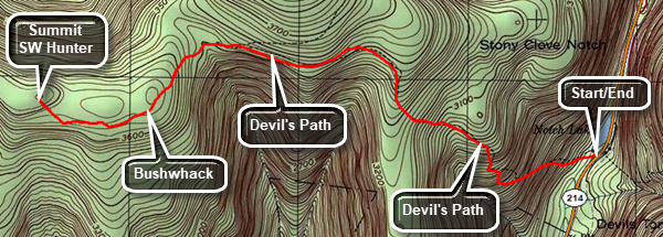
One approach is to park at the Devil's Tombstone State Campgrounds on Stony Clove Road and pay the seasonal parking fee. Find the red-blazed Devil's Path and hike 2.1 miles to the junction with the yellow-blazed Hunter Mountain Trail. Sections of this part of the Devil's Path rise sharply but others are relatively flat. At the junction continue straight ahead to the devil's Acre lean-to and spring. A short distance passed this turn off the Devil's Path and begin a bushwhack to the summit of Southwest Hunter. The trees can be very closely spaced so this is more difficult than the herd path route but also more "fun". After finding and signing in at the canister, retrace your steps back to the parking area.
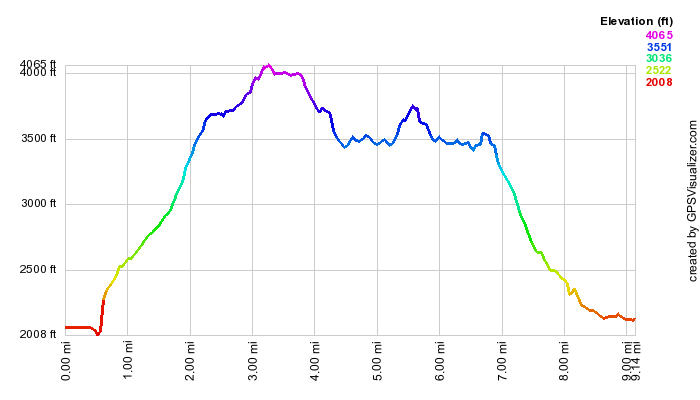
| Quick Look - SW Hunter and Hunter from Notch Lake | ||||
|---|---|---|---|---|
| Difficulty | Round trip | Total climb | Location | Internet Maps |
| 9.5mi. | 2655ft. | N42.1625 W74.2439 | AllTrails | |
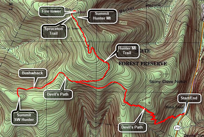
Park at the Devil's Tombstone State Campgrounds on Stony Clove Road and pay the seasonal parking fee. Find the red-blazed Devil's Path and hike 2.1 miles to the junction with the yellow-blazed Hunter Mountain Trail. Sections of this part of the Devil's Path rise sharply but others are relatively flat. At the junction continue straight ahead to the devil's Acre lean-to and spring. A short distance passed this is the remains of an old cog railway bed. Continue passed this point and watch for the path on the left that may be marked by a stone cairn. Leave the Devil's Path to the left and follow the path along the base of the Southwest Hunter ridge. After some time the path turns abruptly to the left and follows a steep route uphill directly to the canister. After finding and signing in at the canister, retrace your steps back to the Devils Path. Turn right and walk back passed the lean-to to the junction with the yellow Hunter Mountain Trail. Walk uphill for 1.3 miles to the junction with the Becker Hollow and Spruceton Trails. The grade is around 7% on the average with some steeper sections. The trail is rocky and highly eroded and the flatter portions at the top can be very wet and muddy. At the junction walk straight ahead on the blue Spruceton Trail. A short walk of .3 miles will bring you to the Hunter fire tower. When you are done at the summit, return to the Spruceton Trail and follow it back to the junction. Make sure you continue straight ahead on the Hunter Mountain Trail. Walk downhill for1.3 miles to the junction with the red Devil's Path. Turn left and walk 2.1 miles back to Notch Lake.
| Quick Look - Loop from Spruceton | ||||
|---|---|---|---|---|
| Difficulty | Round trip | Total climb | Location | Internet Maps |
| 10.2 mi. | 2455 ft. | N42 10.65 W74 13.85 | AllTrails | |
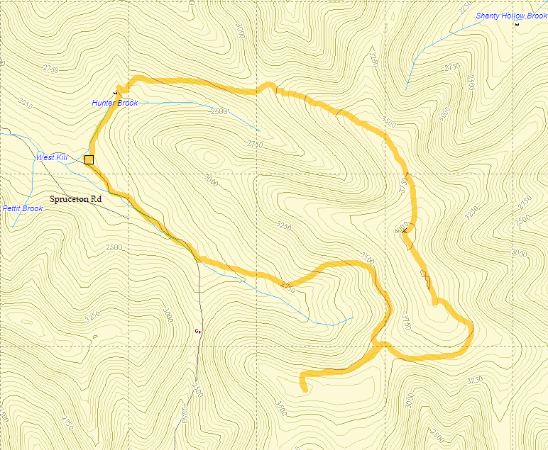 Park at the large trailhead parking lot near the end of the Spruceton Road. This is the first of three parking lots and each is smaller than the previous. Find the blue-blazed Spruceton Trail which
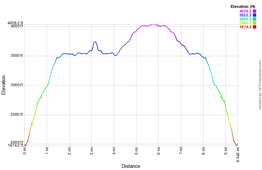
starts as a wide, gated road which follows Hunter Brook. After crossing a small bridge across the brook, you will come to a hairpin turn to the right. In this area you can cross the brook and head northwest to bushwhack Rusk Mt. Look to your right as you ascend the trail after the hairpin for imposing views of West Kill. After 1.7 miles, the trail turns right off the road but remains fairly wide and well kept. In the winter water from the spring can overflow the trail forming ice flows that can be dangerous. In the other seasons this spring may cause the trail to be muddy. Just above the spring at 2.3 miles a spur trail turns to the right and passes through some rocks to the John Robb lean-to. Even if you don't intend to stay overnight, the Len-to has is a nice lookout which offers views of Rusk Mountain, West Kill, and, farther off, North dome and Sherrill. The Spruceton Trail continues uphill and at 2.6 miles a spur trail turns to the left. The Colonel's Chair trail a mile downhill to the top of the slopes at the Hunter Mountain Ski area. The main Spruceton Trail continues uphill to the summit of Hunter Mountain 3.5 miles into the hike.
Park at the large trailhead parking lot near the end of the Spruceton Road. This is the first of three parking lots and each is smaller than the previous. Find the blue-blazed Spruceton Trail which
starts as a wide, gated road which follows Hunter Brook. After crossing a small bridge across the brook, you will come to a hairpin turn to the right. In this area you can cross the brook and head northwest to bushwhack Rusk Mt. Look to your right as you ascend the trail after the hairpin for imposing views of West Kill. After 1.7 miles, the trail turns right off the road but remains fairly wide and well kept. In the winter water from the spring can overflow the trail forming ice flows that can be dangerous. In the other seasons this spring may cause the trail to be muddy. Just above the spring at 2.3 miles a spur trail turns to the right and passes through some rocks to the John Robb lean-to. Even if you don't intend to stay overnight, the Len-to has is a nice lookout which offers views of Rusk Mountain, West Kill, and, farther off, North dome and Sherrill. The Spruceton Trail continues uphill and at 2.6 miles a spur trail turns to the left. The Colonel's Chair trail a mile downhill to the top of the slopes at the Hunter Mountain Ski area. The main Spruceton Trail continues uphill to the summit of Hunter Mountain 3.5 miles into the hike.
After the fire tower, find the yellow-blazed Hunter Mountain Trail that leads to the Devil's Acre lean-to. When you come to the junction with the Becker Hollow Trail and a spur trail to a viewpoint, continue straight ahead on the Hunter Mountain Trail for a total of 1.3 miles to the Devil's Path. The trail is highly eroded and rocky and the flat part near the top is often muddy. Turn right on the Devil's Path and walk to the Devil's Acre lean-to a short distance away. Just passed the lean-to is a small stream and then a ribbon of cinders that cross the trail. This is the remains of a cog railway that went to the summit at one point. Continue passed this point and watch for the path on the left that may be marked by a stone cairn. Leave the Devil's Path to the left and follow the path along the base of the Southwest Hunter ridge. After some time the path turns abruptly to the left and follows a steep route uphill directly to the canister. After finding and signing in at the canister, retrace your steps back to the Devils Path. Turn left on the Devil's Path where there are several short climbs before the trail starts its descent. After about .5 miles there is a short trail to the left to Geiger's Point, splendid lookout. The remaining descent along the Devil's Path is steep at times with many unstable rocks. The 1.15 mile descent drops 1225 feet at a 15% grade until is meets the Diamond Notch Trail and a beautiful waterfall called Diamond Notch Falls. Follow the blue-blazed Diamond Notch Trail along the West Kill to Spruceton Road and walk the road back to the parking area. The distance from the falls to the parking lot is 1 mile.