| Pick a Catskill 35 Peak: |
Big Indian
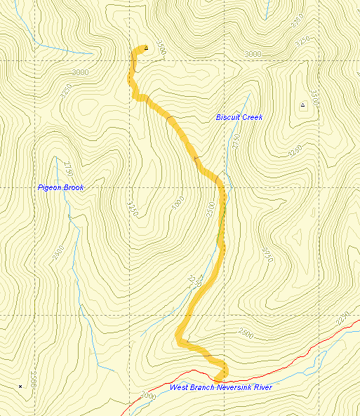
The trail to Big Indian is well-marked and not particularly difficult but the round trip is almost 8 miles. The canister is about .25 miles east of the highest point on the trail. There is a clear path directly to the canister.
| Trailhead Coordinates | |
|---|---|
| Name | Coordinates |
| McKinley Hollow | N42.0710 W74.4740 |
| Rider Hollow | N42.1019 W74.5170 |
| Lost Clove | N42.1058 W74.4701 |
| Biscuit Brook | N41.9911 W74.4849 |
| Segar Hollow | N42.0579 W74.5390 |
| Quick Look - Big Indian from Biscuit Brook | ||||
|---|---|---|---|---|
| Difficulty | Round trip | Total climb | Location | Internet Maps |
| 7.9 mi. | 1989 ft. | N42.0350 W74.4969 | AllTrails | |

Take the Claryville Rd. north from Rt. 55 in Curry outside of Grahamsville. Just short of
Claryville turn left onto the Frost Valley Rd. Pass the Frost Valley YMCA camp and look for the parking
area after a little more than a mile on the right. The road continues on to Rt. 28 at Big Indian so
you may come in from that direction also. From the parking area cross the road and walk away from
Frost Valley to find the blue-blazed Pine Hill-West Branch trail. After 2 miles there is a lean-to on
a short path to the left. To get here you have crossed some tributaries to Biscuit Brook. A short distance
after the lean-to you must cross the main brook. This may be impossible when the water is high and you
don't want to get wet. Across the brook after about 2 miles the trail turns sharply right. After another
.5 miles you will be at the highest point on the trail. The summit of Big Indian Mountain lies about
.25 miles to the east. Look for the herd-hiker path that leads directly to the canister at the true summit
of Big Indian (3700 ft.) Turn around and head back to the parking area.

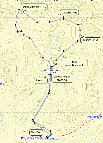
Big Indian is often done in conjunction with Fir since access is off the same trail and there isn't much elevation loss between the two. Fir is a good example of the bushwhack philosophy that says "go off the trail and keep going UP." Either mountain may be done first. This route goes up Big Indian first.
| Quick Look - Big Indian and Fir from Biscuit Brook | ||||
|---|---|---|---|---|
| Difficulty | Round trip | Total climb | Location | Internet Maps |
| approx 9.2 mi. | 2453 ft. | N42 01.65 W74 28.17 | AllTrails | |

Take the Claryville Rd. north from Rt. 55 in Curry outside of Grahamsville. Just short of Claryville turn left onto the Frost Valley Rd. Pass the Frost Valley YMCA camp and look for the parking area after a little more than a mile on the right. The road continues on to Rt. 28 at Big Indian so you may come in from that direction also. From the parking area cross the road and walk away from Frost Valley to find the blue-blazed Pine Hill-West Branch trail. After 2 miles there is a lean-to on a short path to the left. To get here you have crossed some tributaries to Biscuit Brook. A short distance after the lean-to you will cross a tributary of Biscuit Brook and come up a little rise. This may be impossible when the water is high and you don't want to get wet. Across the brook after about 2 miles the trail turns sharply right. After another .5 miles you will be at the highest point on the trail. The summit of Big Indian Mountain lies about .25 miles to the east. Look for the herd-hiker path that leads directly to the canister at the true summit of Big Indian (3700 ft.)
To get to Fir head slightly southeast before turning almost due east. Your goal is to stay on the high ground of the Catskill Divide. Dropping down on either side of this ridge simply means that you will have to climb back up to get to Big Indian. Turn southeast again and then almost due south to get to the canister on Fir. Now head south then southwest always going down. Your goal is to aim for the trail just north of the lean-to. Once on the trail follow it for about 2 miles back to the parking area.
