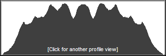
Thomas Cole Mountain
This peak is usually done in conjunction with Black Dome and Blackhead. This makes sense since getting up to the ridge is the longest part of the hike. Each of these three peaks is challenging alone and even more so as a trio. Both of the Blacks have some areas with rock scrambles and exposed rock faces.
| Trailhead Coordinates | |
|---|---|
| Name | Coordinates |
| Batavia Kill | N42.2886 W74.1143 |
| Barnum Road | N42.2639 W74.1767 |
| Quick Look - Blackhead, Black Dome, Thomas Cole T from Big Hollow | ||||
|---|---|---|---|---|
| Difficulty | Round trip | Total climb | Location | Internet Maps |
| 6.7 mi. | 2850 ft. | N42 16.06 W74 06.32 | AllTrails | |
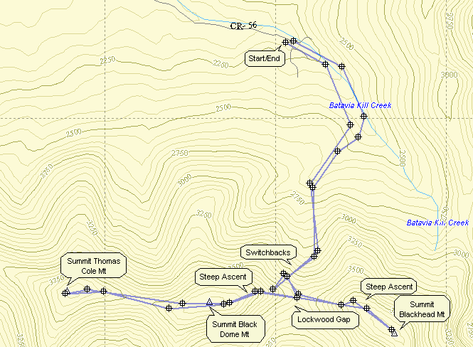
Park at the trailhead at the end of Big Hollow Road. Find the red-blazed Black Dome range Trail and hike .6 miles. At this point bear right to stay on the red trail. A yellow-blazed trail goes off to the left. After another 1.4 miles of ascent with switchbacks to make the climb "easier", you arrive at the Blackhead Mountain trail with only .65 miles to the summit. There is a rather steep ascent here over an open rock face. Make sure you have a good foothold and look back over your shoulder for a great view of Black Dome. The exposed rock that you see is where you will be shortly as you ascend that mountain. A more stable and equally fine view is available as you finish this short, steep climb. Retrace your route back down Blackhead to the col where you picked up the yellow trail. At this point you can simply retrace your route to the parking area if Blackhead was your only goal for the day. If you want to include the other two mountains, get back on the red trail and follow it for .6 miles to the summit of Black Dome. As you climb over the steepest rock scrambles, hold on and look over your shoulder. The exposed rock you see on Blackhead is where you were just a little while ago. From the summit of Black Dome you continue for another rather uneventful .8 miles to the summit of Thomas Cole Mountain. To return, retrace your route back to the col between Black Dome and Blackhead. Stay on the red trail and proceed back to the parking area.

| Quick Look - Blackhead Range Loop from Big Hollow (Blackhead first) | ||||
|---|---|---|---|---|
| Difficulty | Round trip | Total climb | Location | Internet Maps |
| 7.8 mi. | 2850 ft. | N42 16.06 W74 06.32 | AllTrails | |
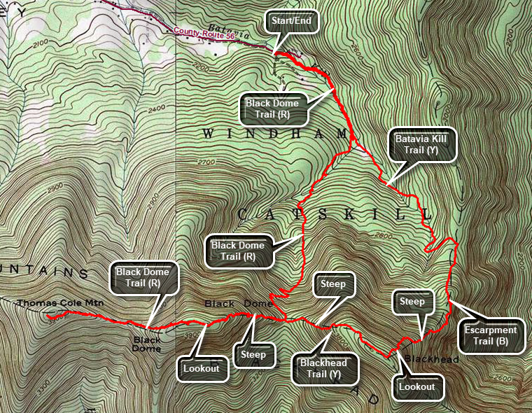
Park at the trailhead at the end of Big Hollow Road. Find the red-blazed Black Dome Range Trail and hike .6 miles. At this point bear left on the yellow-blazed Batavia Kill Trail. After another 1.1 miles turn right on the blue Escarpment Trail and get ready for an even steeper ascent. After ascending over 1000 feet in .85 miles, the trail comes to the summit of Blackhead Mountain. Turn left and walk a short distance to a lookout watching for some old inscriptions on the rocks. Turn around and return to the summit of Blackhead. Continue straight ahead on the yellow Blackhead Mountain Trail which briefly crosses the flat summit before descending steeply to Lockwood Gap. Watch for a lookout along the way. At Lockwood Gap you will have hiked 3.3 miles but it may seem longer. Continue straight ahead on the red Black Dome Trail which begins a short but steep .5 mile ascent to the summit of Black Dome Mountain. There are several possible lookouts along the way. Continue on the Black Dome Trail for another .8 miles to the summit of Thomas Cole. Compared to the trip so far, the section to Thomas Cole is tame. There is no view from the summit. Turn around and retrace your route back to Lockwood Gap. Turn left on the Black Dome trail and follow it for 1.9 miles back to the parking area.

| Quick Look - Blackhead Range Loop from Big Hollow (Black Dome first) | ||||
|---|---|---|---|---|
| Difficulty | Round trip | Total climb | Location | Internet Maps |
| 7.7 mi. | 2840 ft. | N42 16.06 W74 06.32 | AllTrails | |

Park at the trailhead at the end of Big Hollow Road. Find the red-blazed Black Dome Range Trail and hike .6 miles. At this point the yellow-blazed Batavia Kill Trail goes off to the left. Bear right to continue on the Black Dome Range Trail for 1.3 miles to Lockwood Gap. Turn right to stay on the Black Dome Range Trail and to start the steep climb up Black Dome. After .5 miles climbing a 19% grade you will pass the summit of Black Dome 2 miles into the hike. Watch for a lookout on the left of the trail. Continue on the Black Dome Range Trail for another .8 miles to the summit of Thomas Cole. Turn around and follow your route back down Thomas Cole, up and over Black Dome to Lock wood gap at 4.6 miles. Continue straight ahead on the yellow Blackhead Trail for .6 miles to the summit of Blackhead Mountain. This is the steepest climb on this route with short sections approaching a 30% grade. The trail levels at the top and the summit is at a big rock where the short Blackhead Trail meets the blue Escarpment Trail. You can walk a short distance to the right on the Escarpment Trail to find some old inscriptions in the rock. Continuing in this direction for another 1.3 miles brings you to Arizona, a particularly nice viewpoint. From the summit of Blackhead turn left and walk around the rocks and down the blue blazed Escarpment Trail. Down is the most important word as the trail drops 1070 feet in .8 miles averaging a 25% grade with one short section registering 40%. At 6 miles into the hike, turn left on the yellow Batavia Kill Trail which continues to descend for a mile back to the Black Dome Range Trail at a more reasonable grade. At 7 miles turn right on the Black Dome Range Trail and retrace your steps earlier back to the car.

| Quick Look - Thomas Cole only from Barnum Road | ||||
|---|---|---|---|---|
| Difficulty | Round trip | Total climb | Location | Internet Maps |
| 5.2 mi. | 2230 ft. | N42 16.25 W74 08.2 | AllTrails | |
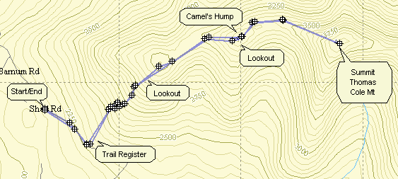
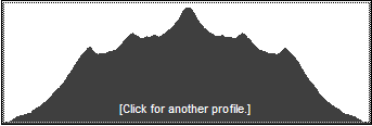
Park at the trailhead on Barnum Road of the Maplecrest Road. Find the red-blazed Black Dome Range Trail that follows an old road for about .45 miles. Turn left off the road and register for the hike. Follow the red trail which climbs steadily for 1.6 miles over two hills named Caudal and Camel's Hump. Some believe that Camel's Hump should be resurveyed as it appears to be over 3500 feet and far enough away from Thomas Cole to be considered a new 35. On the way up the Caudal there is a lookout off the trail to the right. It offers some nice views to the south. Some parts of this trail are steep while others have switchbacks to help keep the climb manageable. Near the top of the Camel's Hump is another more popular lookout to the right. This also offers views to the south but they are more extensive. Continue on the red trail for another .85 miles to the summit of Thomas Cole Mountain. The descent from Camel's Hump into the col is not very difficult. There are very few views along the way. At one point as you walk along the flat area in the col between the Hump and Cole, Thomas Cole Mountain is directly in front of you. The final ascent up Thomas Cole is steep in parts and rather long. There are no views from the summit. Retrace your path back to the parking area.
| Quick Look - Thomas Cole and Black Dome from Barnum Road | ||||
|---|---|---|---|---|
| Difficulty | Round trip | Total climb | Location | Internet Maps |
| 6.92 mi. | 2720 ft. | N42 16.25 W74 08.2 | AllTrails | |
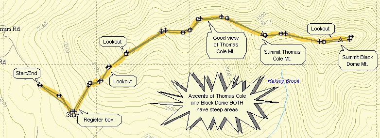
Park at the trailhead on Barnum Road of the Maplecrest Road. Find the red-blazed Black Dome Range Trail that follows an old road for about .45 miles. Turn left off the road and register for the hike. Follow the red trail which climbs steadily for 1.6 miles over two hills named Caudal and Camel's Hump. Some believe that Camel's Hump should be resurveyed as it appears to be over 3500 feet and far enough away from Thomas Cole to be considered a new 35. On the way up the Caudal there is a lookout off the trail to the right. It offers some nice views to the south. Some parts of this trail are steep while others have switchbacks to help keep the climb manageable. Near the top of the Camel's Hump is another more popular lookout to the right. This also offers views to the south but they are more extensive. Continue on the red trail for another .85 miles to the summit of Thomas Cole Mountain. The descent from Camel's Hump into the col is not very difficult. There are very few views along the way. At one point as you walk along the flat area in the col between the Hump and Cole, Thomas Cole Mountain is directly in front of you. The final ascent up Thomas Cole is steep in parts and rather long. There are no views from the summit.
Continue on the red trail for .8 miles to the summit of Black Dome. The descent into the Col and subsequent ascent of Black Dome are both steep and you will repeat them as you retrace your steps back to the parking area! Just before the summit on Black Dome is another lookout again to the south. Retrace your path back to the parking area.

| Quick Look - Blackhead Range from Barnum Road | ||||
|---|---|---|---|---|
| Difficulty | Round trip | Total climb | Location | Internet Maps |
| 6.92 mi. | 2720 ft. | N42 16.25 W74 08.2 | AllTrails | |
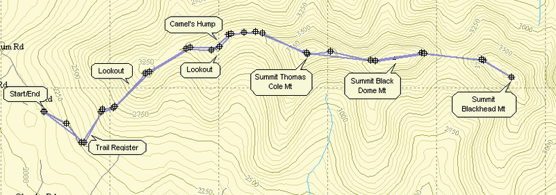
Park at the trailhead on Barnum Road of the Maplecrest Road. Find the red-blazed Black Dome Range Trail that follows an old road for about .45 miles. Turn left off the road and register for the hike. Follow the red trail which climbs steadily for 1.6 miles over two hills named Caudal and Camel's Hump. Some believe that Camel's Hump should be resurveyed as it appears to be over 3500 feet and far enough away from Thomas Cole to be considered a new 35. On the way up the Caudal there is a lookout off the trail to the right. It offers some nice views to the south. Some parts of this trail are steep while others have switchbacks to help keep the climb manageable. Near the top of the Camel's Hump is another more popular lookout to the right. This also offers views to the south but they are more extensive. Continue on the red trail for another .85 miles to the summit of Thomas Cole Mountain. The descent from Camel's Hump into the col is not very difficult. There are very few views along the way. At one point as you walk along the flat area in the col between the Hump and Cole, Thomas Cole Mountain is directly in front of you. The final ascent up Thomas Cole is steep in parts and rather long. There are no views from the summit.
Continue on the red trail for .8 miles to the summit of Black Dome. The descent into the Col and subsequent ascent of Black Dome are both steep and you will repeat them as you retrace your steps back to the parking area! Just before the summit on Black Dome is another lookout again to the south. Continue on this trail for 1.25 miles passing through the col on the way to Blackhead Mountain. The summit of Blackhead as no views but as you ascend the western flank of Blackhead there are great views back to the west at Black Dome. After reaching the rock and trail junction that mark the summit, turn around and retrace your path back to the parking area.
