West Kill Mountain
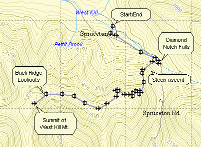
I feel that West Kill has some of the nicest views of all the mountain trails in the Catskills. The Buck Ridge Lookouts afford open and far-ranging views of many of the other surrounding mountains. The beginning of the trail features the Diamond Notch Falls which are worth the walk alone. A bridge crosses the West Kill at the falls and is very picturesque.
| Trailhead Coordinates | |
|---|---|
| Name | Coordinates |
| Spruceton Road (second lot) | N42.1824 W74.2695 |
| Spruceton Road (Mink Hollow) | N 42.1919 W74.3248 |
| Diamond Notch | N42.1498 W74.2647 |
| Quick Look - Westkill from Spruceton | ||||
|---|---|---|---|---|
| Difficulty | Round trip | Total climb | Location | Internet Maps |
| 6.45 mi. | 1780 ft. | N42.1678 W74.2900 | AllTrails | |
 Take Rt. 42 north from Shandaken off Rt. 28. In Spruceton make a right on Spruceton Rd. along the West Kill.
Continue for several miles passed the large parking lot on the left. Park at the next parking lot on the right.
Walk up the road and look for the gate on the blue-blazed Diamond Notch Trail. Walk .7 miles along the
West Kill to Diamond Notch Falls. Walk over the bridge and make an immediate right to walk along the other
side of the West Kill. The trail now ascends quickly and steeply. There is a spring about .7 miles
after the falls. After another .7 miles there is an interesting rock overhang that could be used as a
shelter. Another .9 miles brings you to the Buck Ridge lookouts. There are good views here to the north,
east and south. The summit of West kill (3880 ft.) is just another .1 miles to the west. To complete the hike
retrace your steps down the mountain.
Take Rt. 42 north from Shandaken off Rt. 28. In Spruceton make a right on Spruceton Rd. along the West Kill.
Continue for several miles passed the large parking lot on the left. Park at the next parking lot on the right.
Walk up the road and look for the gate on the blue-blazed Diamond Notch Trail. Walk .7 miles along the
West Kill to Diamond Notch Falls. Walk over the bridge and make an immediate right to walk along the other
side of the West Kill. The trail now ascends quickly and steeply. There is a spring about .7 miles
after the falls. After another .7 miles there is an interesting rock overhang that could be used as a
shelter. Another .9 miles brings you to the Buck Ridge lookouts. There are good views here to the north,
east and south. The summit of West kill (3880 ft.) is just another .1 miles to the west. To complete the hike
retrace your steps down the mountain.
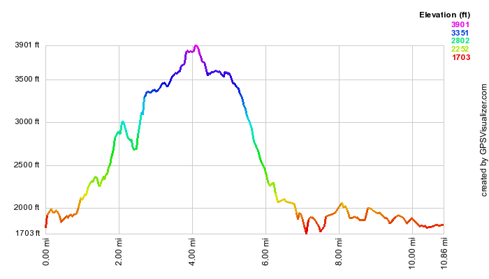
(The image above shows the overall vertical profile of the hike in the outbound direction. Notice the VERY gradual increase in elevation to start. The falls are at the base of the steep climb.)
| Quick Look - Westkill Loop from Mink Hollow | ||||
|---|---|---|---|---|
| Difficulty | Round trip | Total climb | Location | Internet Maps |
| 10.85 mi. | 2950 ft. | N42 10.08 W74 17.40 | AllTrails | |
 Take Rt. 42 north from Shandaken off Rt. 28. In Spruceton make a right on Spruceton Rd. along the West Kill.
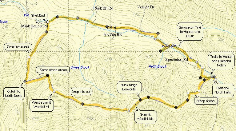
Continue for several miles until the first small parking area on the left marked with the yellow on brown signs. This
is the Mink Hollow parking area and is the extreme western end of the Devil's Path. This end gets much less traffic than
the other and the trail is more overgrown in places and less well-defined. Get on the trail and walk to the register a
few hundred yards up into the woods. The first part of the trail seems to be a steep climb out of the parking area but
then starts to moderate some as it follows a small brook. the trail can be wet at times and swampy on the right giving
rise to all sorts of biting insects. At about 1.4 miles into the hike the trail turns sharply to the left. This is a
good spot to turn to the right if you want to brave the swamp and the nettles to start a bushwhack on North Dome.
Take Rt. 42 north from Shandaken off Rt. 28. In Spruceton make a right on Spruceton Rd. along the West Kill.
Continue for several miles until the first small parking area on the left marked with the yellow on brown signs. This
is the Mink Hollow parking area and is the extreme western end of the Devil's Path. This end gets much less traffic than
the other and the trail is more overgrown in places and less well-defined. Get on the trail and walk to the register a
few hundred yards up into the woods. The first part of the trail seems to be a steep climb out of the parking area but
then starts to moderate some as it follows a small brook. the trail can be wet at times and swampy on the right giving
rise to all sorts of biting insects. At about 1.4 miles into the hike the trail turns sharply to the left. This is a
good spot to turn to the right if you want to brave the swamp and the nettles to start a bushwhack on North Dome.
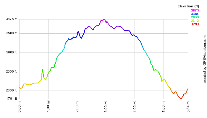
The Devil's Path turns left and the elevation increases quickly. The trail remains wet in all but the driest seasons as several small springs and brooks add to the moist conditions. Lush expanses of briars and stinging nettles infest the trail. After a mile of climbing with some steep areas you reach the top of the western summit of Westkill. This peak itself is 3400 feet but has no view to speak of. A descent into the col between the two summits begins almost immediately. It is relatively short but steep over slippery rocks at times. In less than two miles a sign marks the summit of the eastern peak of Westkill. There is no view from this point but a short walk brings you to the Buck Ridge lookouts. These looks outs provide an almost unhindered view of the hills and valleys around Westkill. The entire panorama from both lookouts must be close to 270 degrees.
The descent to the east from the lookouts is steep at times and can be treacherous in the winter or after a rain
has soaked the rocks. After less than a mile there is a "cave" or overhanging rock ledge that can prove to be a shelter
during a storm. After a little more than two miles of descent, you arrive at Diamond Notch Falls. The falls are always
pretty but are nicer when there is a larger volume of water flowing over them. It is possible to walk out onto the
falls but be careful of the slippery rocks. You can also got to the base of the falls from either side of the Westkill.
A bridge above the falls offers and easy crossing and another view. From here there are several choices of trails. The
Devil's Path continues up to the Devil's Acre lean-to and the path to Hunter Mountain. The Diamond Notch Trail goes out
to the Diamond Notch parking area. Go over the bridge and turn right onto the wide Spruceton Trail to get back to your
car. The walk to the road is less than a mile but the walk on the road back to the car is almost four miles. The option
of taking the Devil's Path and then going on up to Hunter is an attractive one. At the top of Hunter you can take the
Spruceton Trail back down to Spruceton Road. This forms a bigger loop. Remember that this adds the second highest peak
in the Catskills and at least another 6 miles to the hike!