
Rusk Mountain
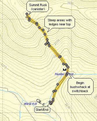
Rusk can be climbed in conjunction with Hunter and Southwest Hunter. As bushwhacks go it is not too long but can be difficult. The approach from the switchback on the Spruceton Trail is steep in places with some ledges to negotiate near the top. Sliding further to the east lengthens the hike and may not make it much easier. Approaching from the east along the ridge line may be the easiest path but is MUCH longer. This mountain usually has a nice crop of nettles in season. a tributary of Hunter Creek leads almost directly to the summit and often has very little water flowing. The canister is slightly north and west of the highest point marked on my GPS. The canister is red!
| Trailhead Coordinates | |
|---|---|
| Name | Coordinates |
| Spruceton Road (first lot) | N42.1847 W74.2719 |
| Quick Look - Rusk from Spruceton | ||||
|---|---|---|---|---|
| Difficulty | Round trip | Total climb | Location | Internet Maps |
| approx 3.0 mi. | 1590 ft. | N42.2006 W74.2775 | AllTrails | |
 Take Rt. 42 north from Shandaken off Rt. 28. In Spruceton make a right on Spruceton Rd. along the West Kill.
Continue for several miles and stop at the large parking lot on the left. Find the blue-blazed Spruceton
Trail which starts on the Old Hunter Road. After about .5 miles go off the trail at the switchback and cross
Hunter Brook. At one point a tributary of Hunter Brook comes down the mountain. If you follow this, it will take you
almost to the canister at the Summit of Rusk Mountain (3680 ft.) The distance and difficulty will vary as you bushwhack
but should be about 1 mile after leaving the Spruceton Trail. Some areas are very steep. Watch the rock ledges near the
top on the ascent but especially be careful on the descent since the vegetation is thick and you may not be able to
clearly see where your next step will land. Be aware that open areas seem to be attractive but may be teeming with
nettles. Retracing your steps is the best way to return to the Spruceton Trail. At this point you can return to the
parking area or turn left and head for more adventures on Hunter Mountain.
Take Rt. 42 north from Shandaken off Rt. 28. In Spruceton make a right on Spruceton Rd. along the West Kill.
Continue for several miles and stop at the large parking lot on the left. Find the blue-blazed Spruceton
Trail which starts on the Old Hunter Road. After about .5 miles go off the trail at the switchback and cross
Hunter Brook. At one point a tributary of Hunter Brook comes down the mountain. If you follow this, it will take you
almost to the canister at the Summit of Rusk Mountain (3680 ft.) The distance and difficulty will vary as you bushwhack
but should be about 1 mile after leaving the Spruceton Trail. Some areas are very steep. Watch the rock ledges near the
top on the ascent but especially be careful on the descent since the vegetation is thick and you may not be able to
clearly see where your next step will land. Be aware that open areas seem to be attractive but may be teeming with
nettles. Retracing your steps is the best way to return to the Spruceton Trail. At this point you can return to the
parking area or turn left and head for more adventures on Hunter Mountain.
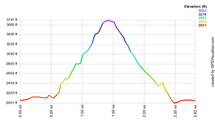
(The image above is the vertical profile for the hike up to the peak. The profile is a fair representation of the steepness of the climb. This bushwhack is not as difficult as some and it is not as long.)
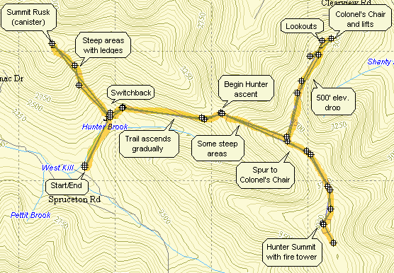
| Quick Look - Rusk, Hunter and Colonel's Chair from Spruceton | ||||
|---|---|---|---|---|
| Difficulty | Round trip | Total climb | Location | Internet Maps |
| approx 10.8 mi. | 3980 ft. | N42 12.05 W74 16.65 | AllTrails | |
 Take Rt. 42 north from Shandaken off Rt. 28. In Spruceton make a right on Spruceton Rd. along the West Kill.
Continue for several miles and stop at the large parking lot on the left. Find the blue-blazed Spruceton
Trail which starts on the Old Hunter Road. After about .5 miles go off the trail at the switchback and cross
Hunter Brook. At one point a tributary of Hunter Brook comes down the mountain. Turn left and cross the brook at this point. Follow this, it will take you almost to the canister at the summit of Rusk Mountain (3680 ft.) The distance and difficulty will vary as you bushwhack but should be about 1 mile after leaving the Spruceton Trail. Some areas are very steep. Watch the rock ledges near the top on the ascent but especially be careful on the descent since the vegetation is thick and you may not be able to clearly see where your next step will land. Be aware that open areas seem to be attractive but may be teeming with nettles. Retracing your steps is the best way to return to the Spruceton Trail. At this point you can return to the parking area or turn left and head for more adventures on Hunter Mountain.
Take Rt. 42 north from Shandaken off Rt. 28. In Spruceton make a right on Spruceton Rd. along the West Kill.
Continue for several miles and stop at the large parking lot on the left. Find the blue-blazed Spruceton
Trail which starts on the Old Hunter Road. After about .5 miles go off the trail at the switchback and cross
Hunter Brook. At one point a tributary of Hunter Brook comes down the mountain. Turn left and cross the brook at this point. Follow this, it will take you almost to the canister at the summit of Rusk Mountain (3680 ft.) The distance and difficulty will vary as you bushwhack but should be about 1 mile after leaving the Spruceton Trail. Some areas are very steep. Watch the rock ledges near the top on the ascent but especially be careful on the descent since the vegetation is thick and you may not be able to clearly see where your next step will land. Be aware that open areas seem to be attractive but may be teeming with nettles. Retracing your steps is the best way to return to the Spruceton Trail. At this point you can return to the parking area or turn left and head for more adventures on Hunter Mountain.
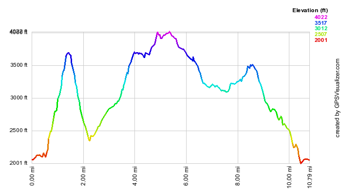
(The image at the left is the vertical profile for the hike up to the peak. The profile is a fair representation of the steepness of the climb. This bushwhack is not as difficult as some and it is not as long.)