Dry Brook Ridge
Huckleberry Ridge: Complete Huckleberry Loop
| Quick Look | ||||
|---|---|---|---|---|
| Difficulty | Round trip | Total climb | Internet Maps | |
| 11.2 mi. | 3075 ft. | AllTrails | ||

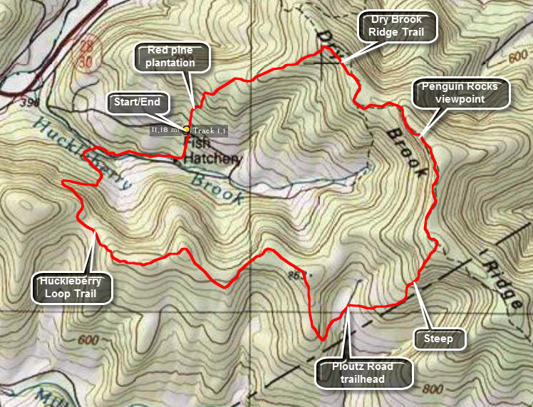
There are several different ways to access this loop hike area from the Margaretville and Arkville areas. The Huckleberry Loop Trail crosses Hill Road and runs along Huckleberry Brook Road. There is a parking area on Hill Road and two on Huckleberry Brook Road. There is also a parking areas on Ploutz Road of the Millbrook Road but Ploutz Road is poorly maintained. This route starts at the Hill Road parking area and heads south to the lower Huckleberry Loop Trail first and then proceeds up Dry Brook Ridge in a counterclockwise direction. The lower Huckleberry Loop Trail is NOT a trail for a good part of its length! Make sure you are willing to slog through heavy briars and undergrowth for about 3 miles!
From Routes 28 and 30 in Margaretville get on Southside Road. You may also use BWS Route 10 if you are coming from the Pepacton Reservoir to the west. Watch for the turn onto Huckleberry Brook Road. It is about 2 miles from Margaretville and less than a mile from the junction of BWS Route 10 with Routes 28 and 30. After turning onto Huckleberry Road, watch for the turn onto Hill Road about a quarter mile up on the right. Continue on Hill Road for a little over 1 mile until you see signs for "wild forest". The parking area will be on the right and is small with only enough room for a few cars. From the parking area walk up the road a few feet and turn right into the woods on the red Huckleberry Loop Trail.
Walk .3 miles south on the trail to the upper parking area on Huckleberry Brook Road. Bear right near the road, walk through a small open area and cross the bridge to the road. Walk west on the road for .8 miles to the lower parking area. Just passed the parking area on the left is a bridge over Huckleberry Brook. Sign the register here and get ready to start climbing right away. The trail soon merges with an old woods road and follows it until about .4 miles after the bridge. At this point it turns again and starts to climb the ridge. Be careful to make the turn to the right as the road continues straight ahead. For the next .85 miles the trail switches back several times as it climbs to the ridge line. Watch for some very large and very old hardwood and softwood trees. In addition, there are some impressive rock formation that show exceptionally clear sedimentary layers. At this point the trail begins to deteriorate. If you are lucky, someone will have cut down some of the briars, brush and undergrowth but the going will still be tough! For the next 3.5 miles you will have to hack your way through raspberry canes, briars, nettles, ferns and various bushes. You will do this without being able to see the rocks and fallen trees under foot that will trip you up. You will also be treated to several ascents and descents of small hills on your way to the parking area on Ploutz Road. At 5.3 miles the highest point on Huckleberry Ridge will be to the east or on the left side of the trail. Hike off the trail to the highest point and then return to the trail.
When you get to the trailhead on Ploutz Road you will have hiked about 6.5 miles but it will feel like half again as much distance. To get to Ploutz Road you will have dropped down from the ridge and then ascended to about 2400 feet. What awaits you is another 5 miles of hiking which starts with an ascent to the top of Dry Brook Ridge at almost 3500 feet. Walk across the road to the parking area and continue on the red trail. The trail now ascends for a little over a mile to the ridge. The ascent starts and ends easily but the parts in between can be steep at times! By sure to bushwhack off the trail to the north since the trail does NOT cross the highest point on the ridge! At the ridge the trail flattens and in about .35 miles you will reach the junction with the blue Dry Brook Ridge Trail. Turn left toward Margaretville and walk for about .8 miles to a viewpoint over Cold Spring Hollow and the Pepacton Reservoir. Another .7 miles of walking brings another set of lookouts with much the same view. Continue on the trail for another 1 mile until the junction with the red Huckleberry loop trail. Turn left on the trail and hike 1.55 miles back to the parking area on Hill Road. This descent is rather and you can make good time walking downhill. The trail descends not too steeply first through hardwoods and then narrows in several places as it leaves the meandering woods road. In these places some briars and nettles may encroach on the trail. After some more hard woods the trail merges with and stays on an old woods road that runs through a pine plantation where the trees are evenly spaced. The trail is wide as it overlaps an old woods road. The floor is covered with pine needles which makes it cushioned and easy to walk on. In at least one spot are some old foundations and in others stone walls.
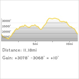
 (The image at the left shows the profile of the hike. Remember that all vertical profiles are
relative!)