
Bowling Green Mountain
| Quick Look | |||||
|---|---|---|---|---|---|
| Difficulty | Round trip | Total climb | Location | Elevation | Internet Maps |
| 6.79 mi | 1350 ft | N41.0077 W74.5498 Morris | 1381 ft | AllTrails | |
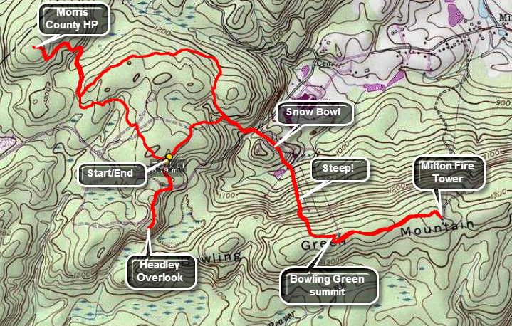 Park at the picnic area at Mahlon Dickerson Reservation which can be reached from Route 15 near Lake Hopatcong. There is an extensive trail network and it is marked but can be confusing. Across the road from the parking area a trail leads to the Headley Overlook. The round trip is under 1 mile but the overlook just isn't that good if there are any leaves on the trees. From the parking area walk down a trail to the northeast that parallels Weldon Road. When a trail branches toward Weldon Road to the east or southeast turn right and cross Weldon Road toward the old Snow Bowl ski area. There is a dirt bike track on the right but you should follow the road on the left that heads toward a ridge which is Bowling Green. Pass through a steel gate and by some ruins staying on the road which is the access road to the cell tower on top of the ridge. You may stay on the road for the entire hike but it is longer than heading straight up the trail next to the road. At one point the road turns right in sort of a switchback but you should continue up the trail. It is steep in places but will bring you out on the road very near the cell tower. Turn left and walk to the top and wander around until you find the highest spot. The distance so far is only about 1.3 miles. At this point you can return to the parking area by reversing the route or choose to stay on the ridge and visit the Milton fire tower at the other end. The fire tower, one of the highest in the state, is defined worth the trip especially there is no haze or humidity! The distance to the tower is only .6 miles and it IA flat. Now you can go back to the car or choose to visit the Morris County High Point on the other side of the road.
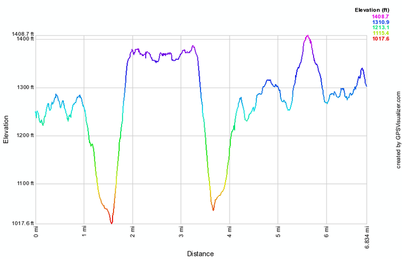 (The image at the left shows the profile of the hike. Remember that all vertical profiles are
relative!)
(The image at the left shows the profile of the hike. Remember that all vertical profiles are
relative!)