
What You Missed
Winter 2018 - 2019
Winter 2018
![]()
![]()
![]()
![]()
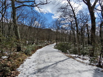
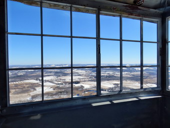
![]() On Saturday, March 16th, I asked Cindy if she would like to go somewhere to hike. She said "Yes" but I knew she would not want to hike any huge mountains. I suggested we try to stay away from areas that would be exceptionally muddy and suggested Sam's Point. We had not been in the area for some time and I hoped that, although it was popular, there wouldn't be too many visitors. Cindy agreed and we planned to leave about 10:00 AM. Since I have been teaching again full time, I have not had as much time to hike with Sheila so she kept her eye on me as I began to get ready. The temperature as I was getting ready was still in the low 30's and the forecast was for brisk winds. I put on a long-sleeved base layer and wore my Mammut pullover which is heavier than most others I own. I put on a pair of tights underneath my Columbia Omniheat hiking pants which have a reflective lining. The pants have Velcro closures at the ankles which means gaiters are not usually needed until the snow gets deeper. I donned my Mammut hoody which has enough zippers to dump heat if needed. I put on a hat and gloves. I wore my Keen Galrus hiking boots as I did not expect much snow. I did notice they felt a little tight from not having been worn in some time. I did put on a pair of OR Crocodile gaiters to fend off the ticks which II thought might be out in the warmer weather. I grabbed a pair of Leki poles with external locks that I have been using lately. Cindy and I both brought our spikes just in case we ran into more ice than I had anticipated. I got our gear in Cindy's car and put Sheila in the backseat before heading out the driveway. We stopped to check the mail and then I headed south and east on the Quickway to Liberty a little after 10:00 AM. I took Route 52 toward Woodbourne and Ellenville. In Ellenville I continued on Route 52 up the mountain toward Cragsmoor. At the top of the mountain I turned left and headed toward Cgrasmoor where I turned right on Sams Point Road. In a few minutes we were approaching the Visitor Center at Sam's Point. When we got to the parking area, there were a few cars and some people starting out to hike. I went to the Visitor's Center and paid $10 to park. The attendant cautioned me that the trails were icy and spikes would be a good idea. I went back to the car and got our gear ready to hike setting my GPS unit. We started hiking toward the Loop Road with Sheila on her leash. Where the road split, we turned right to head up to Sam's Point first. We were immediately presented with a sheet of ice covering the road. We both stopped and decided to put on our spikes as other hikers passed us slipping and sliding on the ice. The spikes went on quickly and we started hiking again. The spikes gave us great traction and we quickly passed those who had no traction. We followed the switchbacks to some ledges just below Sam's Point. I stopped here to take some pictures of the valley below. Cindy went to check out the ice ahead which seemed to be disappearing. As I took pictures of the blue skies and white clouds, the wind intensified and I decided to get off the ledges. Cindy reported that our spikes would not be necessary so I took them off and put them in my pack. We walked to the top of the hill and turned left on the path to Sam's Point. After a short walk, I put my pack down and gave Cindy Sheila's leash. I walked out to the point and took some more pictures. The wind was still blowing so I quickly finished my photography as some of the other hikers arrived. Cindy and I walked back out to the Loop Road and turned left.
On Saturday, March 16th, I asked Cindy if she would like to go somewhere to hike. She said "Yes" but I knew she would not want to hike any huge mountains. I suggested we try to stay away from areas that would be exceptionally muddy and suggested Sam's Point. We had not been in the area for some time and I hoped that, although it was popular, there wouldn't be too many visitors. Cindy agreed and we planned to leave about 10:00 AM. Since I have been teaching again full time, I have not had as much time to hike with Sheila so she kept her eye on me as I began to get ready. The temperature as I was getting ready was still in the low 30's and the forecast was for brisk winds. I put on a long-sleeved base layer and wore my Mammut pullover which is heavier than most others I own. I put on a pair of tights underneath my Columbia Omniheat hiking pants which have a reflective lining. The pants have Velcro closures at the ankles which means gaiters are not usually needed until the snow gets deeper. I donned my Mammut hoody which has enough zippers to dump heat if needed. I put on a hat and gloves. I wore my Keen Galrus hiking boots as I did not expect much snow. I did notice they felt a little tight from not having been worn in some time. I did put on a pair of OR Crocodile gaiters to fend off the ticks which II thought might be out in the warmer weather. I grabbed a pair of Leki poles with external locks that I have been using lately. Cindy and I both brought our spikes just in case we ran into more ice than I had anticipated. I got our gear in Cindy's car and put Sheila in the backseat before heading out the driveway. We stopped to check the mail and then I headed south and east on the Quickway to Liberty a little after 10:00 AM. I took Route 52 toward Woodbourne and Ellenville. In Ellenville I continued on Route 52 up the mountain toward Cragsmoor. At the top of the mountain I turned left and headed toward Cgrasmoor where I turned right on Sams Point Road. In a few minutes we were approaching the Visitor Center at Sam's Point. When we got to the parking area, there were a few cars and some people starting out to hike. I went to the Visitor's Center and paid $10 to park. The attendant cautioned me that the trails were icy and spikes would be a good idea. I went back to the car and got our gear ready to hike setting my GPS unit. We started hiking toward the Loop Road with Sheila on her leash. Where the road split, we turned right to head up to Sam's Point first. We were immediately presented with a sheet of ice covering the road. We both stopped and decided to put on our spikes as other hikers passed us slipping and sliding on the ice. The spikes went on quickly and we started hiking again. The spikes gave us great traction and we quickly passed those who had no traction. We followed the switchbacks to some ledges just below Sam's Point. I stopped here to take some pictures of the valley below. Cindy went to check out the ice ahead which seemed to be disappearing. As I took pictures of the blue skies and white clouds, the wind intensified and I decided to get off the ledges. Cindy reported that our spikes would not be necessary so I took them off and put them in my pack. We walked to the top of the hill and turned left on the path to Sam's Point. After a short walk, I put my pack down and gave Cindy Sheila's leash. I walked out to the point and took some more pictures. The wind was still blowing so I quickly finished my photography as some of the other hikers arrived. Cindy and I walked back out to the Loop Road and turned left.
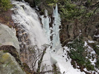 This part of the Loop Road had some ice and snow but it was easy to avoid these patches. When we reached the road that leads to the Ice Caves, we turned right and walked downhill. At the trail to Verkeerder Kill Falls, we turned left and negotiated some ice to get on the trail. We had not been in this area since the fires that had destroyed hundreds of acres at Sam's Point. The trees in the area still showed the scars of that fire but we could also see that new, green branches were growing from the bases of most of these trees. We continued along the trail until I could see some great views of the valley below. From this vantage point we could also see Lake Awosting, Castle Point and Hamilton Point. We stopped so I could take some pictures and so that some hikers could pass us OM the way to the falls. I packed up and we continued along the trail which alternated between bare rock, ice stretches and areas of flowing water. This part of the trail always seems longer than I remember and this days was no exception. The total distance to the falls is 1.75 miles and has an elevation drop of over 500 feet. The slope is not steep but it is relentless. There were some tricky spots along the way and we found it important to concentrate on what we were doing. The wind continued to blow but we were largely sheltered by the trees along the way. Soon we were approaching the falls and I began looking for a way to get to a ledge that overlooks the falls. I left Sheila with Cindy and walked through the brush to find a path down to the ledge. When I got to the ledge, I took off my pack and got out the camera. The falls were flowing freely with ice frozen along the side of the falls. At the bottom of the falls was a large amount of ice that had accumulated from the spray coming from the falls. I worked my way carefully along the ledge and took pictures of the falls, the area below the falls and some downstream from the falls. I looked at the other side of the falls and could see layers of ice covering many of the viewpoints. After taking a few more pictures, I packed up and headed back to Cindy. We decided that it would be too dangerous to cross the stream and try to see the falls from the other. We turned around and started back up the trail we had just descended.
 As we hiked up the trail, we kept meeting hikers in groups coming down to visit the falls. By the time we were back at Ice Caves Road the number had swollen to 26 people. Climbing back up the trail was tiring but seemed easier than descending over the ice. The temperature seemed a little higher but the wind began blowing as we left the protection of the trees. At the road, we turned right and walked up to the Loop Road. We turned right here to hike around the Lake Maratanza and back to the car. As we approached the lake, we looked ahead and saw what looked like snow banks ahead. I could also see that the lake was still frozen. The snow banks were real and had formed as the winds swept the snow off the lake all winter! These drifts were almost three feet high in places. At one point we stopped, even though the wind was blowing hard across the lake, so that I could take some pictures of the lake and the snow drifts. We continued along the eastern shore of the lake slogging through the drifts. Along the way we met a half dozen people coming toward us. Soon we were on the north shore of the lake and the snow all but disappeared. The trail continued to have some ice and packed snow but not enough to warrant spikes. At 5.6 miles we came to the carriageway to High Point on the right and for a moment I thought about hiking there. The distance was 1.7 miles to the High Point Trail and I knew it was at least another .3 miles to High Point and I knew we were not ready for another 4 miles. We continued on the Loop Road passing several communications towers along the way. After descending a little, the trail flattened and we passed an area that had the remains of several berrypicker's shacks. From the mid 1800's to the mid 1900's, people camped in the area and picked blueberries. They sold the berries as a source of income and there is still a good crop of berries in this area. As we walked we passed by another shack and then the South Gully Trail on the right. The South Gully Trail is also the route for the Long Path and leads down to Route 52. It follows a stream which has many small waterfalls and cascades. At Route 52, hikers cross the road and follow the Long Path along the Shawangunk Ridge Trail to Wurtsboro. We continued on the road which was now covered in snow and ice. I stopped one more time to take some pictures of another shack. We walked down the final small hill to the parking area and the car. The parking area had considerably more cars than when we started. It was 3:20 PM and we had spent 4 hours and 5 minutes hiking 6.8 miles. The elevation gain was 885 feet and we had stopped for over 35 minutes. On the way home I stopped and Route 52 to take some pictures of the Catskills. We stopped at Gabby's in Ellenville for Mexican food before returning home.
![]()
![]()
![]()
![]()
![]() On Saturday, March 9th, Cindy and I had already hiked at Ferncliff Forest near Rhinecliff and visited the tower there. We entered an approximate address for the Stissing Mountain Thompson Pond area and followed the directions. We followed Route 199 east and then took Route 308 south to Rhinebeck. Route 308 took us east and a little north before meeting Route 199 again! We followed Route 199 until just before the village of Pine Plains. On our way we could see the tower high on a mountain just to the south of the road. There are several different trails to the top of the mountain but I had read conflicting stories about them. Many of these stories asserted that two of the approaches crossed private land and that any easements had been revoked. I decided we would use the trail from the Thompson Pond area on Lake Road and so we made the turn south off Route 199. We drove along the road for about 1.3 miles to the parking area on the left side of the road. I remember we had trouble finding where to park last time. This time we found the parking area immediately but found there was no place to park. I turned the car around and parked along the side of the road. I walked over to the beginning of the trail to make sure I knew where we were gong. There wasn't much snow but there was some mud. I went back to the car, set my GPS, and put Sheila on her leash. We crossed the road at about 12:30 PM, walked through the gate and began to immediately climb. The road was very eroded so we walked along the side when we could trying to stay out of the mud and away from the occasional ice and snow patches. There was only a little snow and ice at this elevation. The climb from the road was steep and I remember thinking last time we were at this location that there is little time to warm up. Sheila alerted almost immediately and we could see a group of six hikers coming down the trail. As they approached, I took Sheila by the collar and walked off the side of the trail. The hikers said "hello" and continued down the trail. They seemed to know what they were doing but none had poles or traction devices. We continued up the trail encountering two more hikers one of whom had a dog on a leash. After a little more than .25 miles we came to a fork in the trail marked by a stone cairn. I decided we would climb the steeper trail to the left and descend the more gentle one to the right. I felt this was the safer plan remembering some of the "features" of the trail from previous trips. For the next .5 miles the trail averaged a 23% grade with some spots flatter and others steeper. We could see that several inches of snow covered a layer of ice. We decided to stop on put on our spikes. As we finished securing the spikes, we could see another hiker approaching with a dog. We continued up the steep trail hoping he would go the other way. He soon caught up to us and did not have his dog on a leash. I was annoyed and said a quick "Hello" as I stepped aside to let him pass. There were some tricky areas especially as we neared the summit. We had to work our way around several icy areas and I assumed anyone without spikes and ascended and descended the other trail which has a gentler slope. We were able to work around the icy areas and by 1:20 PM we were at the tower after only .75 miles.
On Saturday, March 9th, Cindy and I had already hiked at Ferncliff Forest near Rhinecliff and visited the tower there. We entered an approximate address for the Stissing Mountain Thompson Pond area and followed the directions. We followed Route 199 east and then took Route 308 south to Rhinebeck. Route 308 took us east and a little north before meeting Route 199 again! We followed Route 199 until just before the village of Pine Plains. On our way we could see the tower high on a mountain just to the south of the road. There are several different trails to the top of the mountain but I had read conflicting stories about them. Many of these stories asserted that two of the approaches crossed private land and that any easements had been revoked. I decided we would use the trail from the Thompson Pond area on Lake Road and so we made the turn south off Route 199. We drove along the road for about 1.3 miles to the parking area on the left side of the road. I remember we had trouble finding where to park last time. This time we found the parking area immediately but found there was no place to park. I turned the car around and parked along the side of the road. I walked over to the beginning of the trail to make sure I knew where we were gong. There wasn't much snow but there was some mud. I went back to the car, set my GPS, and put Sheila on her leash. We crossed the road at about 12:30 PM, walked through the gate and began to immediately climb. The road was very eroded so we walked along the side when we could trying to stay out of the mud and away from the occasional ice and snow patches. There was only a little snow and ice at this elevation. The climb from the road was steep and I remember thinking last time we were at this location that there is little time to warm up. Sheila alerted almost immediately and we could see a group of six hikers coming down the trail. As they approached, I took Sheila by the collar and walked off the side of the trail. The hikers said "hello" and continued down the trail. They seemed to know what they were doing but none had poles or traction devices. We continued up the trail encountering two more hikers one of whom had a dog on a leash. After a little more than .25 miles we came to a fork in the trail marked by a stone cairn. I decided we would climb the steeper trail to the left and descend the more gentle one to the right. I felt this was the safer plan remembering some of the "features" of the trail from previous trips. For the next .5 miles the trail averaged a 23% grade with some spots flatter and others steeper. We could see that several inches of snow covered a layer of ice. We decided to stop on put on our spikes. As we finished securing the spikes, we could see another hiker approaching with a dog. We continued up the steep trail hoping he would go the other way. He soon caught up to us and did not have his dog on a leash. I was annoyed and said a quick "Hello" as I stepped aside to let him pass. There were some tricky areas especially as we neared the summit. We had to work our way around several icy areas and I assumed anyone without spikes and ascended and descended the other trail which has a gentler slope. We were able to work around the icy areas and by 1:20 PM we were at the tower after only .75 miles.
 Once at the tower I dropped my pack, leashed Sheila to a tree and took off my spikes. It was hard to get pictures of the tower as it is surrounded by trees. I estimated that the temperature had risen to the mid 30's and it was much warmer in the sun. There was a family on the tower and I waited until some of them came down to start my climb. Cindy decided to stay on the ground this time with Sheila. I climbed about three-quarters of the way up and found a breeze blowing which immediately chilled me. I took some pictures to the east. Thompson Pond and Stissing Lake were visible with the Taconic Mountain in the background. The ponds have a bog environment which was evident in their formation even from far above. I climbed into the cab of the tower to look around and took more shots from there. Eventually it was time to descend the tower. I shared a drink and a snack with Cindy before heading back down on the other trail to form a lollipop loop. As we started out another couple came up with a dog they had not bothered to leash. The dog would not listen to the owners so We had to stop until they could get a hold on the dog's collar. People can be very stupid and certainly inconsiderate! We walked passed the tower on the trail and tired right to head down. The trail was snow covered hiding a layer of ice underneath. This made for slow going but it was easier than the ascent. At the bottom of a short descent the trail turned right to parallel our route up the mountain. Our spikes definitely made walking over the ice easier. We crossed a small brook and continued to head down the mountain. I caught a glimpse of Little Stissing and it was clear we were headed between the two mountains. At 1.6 miles we were back at the stone cairn where the trail splits. We retraced our steps toward the car meeting one more hiker coming up the trail. I decided to take off my spikes on the rest of the short descent while Cindy left her's on. I thought it ironic that I slipped and almost fell more times on the mud than I had on the ice and snow. We were back at the car at 2:15 PM having covered 1.9 miles in 1 hour and 45 minutes wit 30 minutes of stopped time. The elevation gain was only 900 feet but there were some very steep areas. On the way home we stopped at Gabby's in Ellenville for some very good Mexican food.
![]()
![]()
![]()
![]()
![]() On Saturday, March 9th, I asked Cindy if she would like to go somewhere to hike. She said "Yes" but I knew she would not want to hike any huge mountains or for very many hours. I suggested we go to some fire towers on the east side of the Hudson River. I wanted to get away from the my usual haunts around Livingston Manor and the weather forecast seemed ideal. Although it was only 12 degrees when I got up at 6:00 AM, the temperature was supposed tom rise into the low 40's. Cindy agreed and we planned to leave about 9:00 AM. Since I have been teaching again full time, I have not had as much time to hike with Sheila so she kept her eye on me as I Egan to get ready. We knew that dogs were allowed where we were going as long as they were on a leash. I put on a long-sleeved base layer and wore my Mammut pullover which is heavier than most others I own. I put on a pair of tights underneath my Columbia Omniheat hiking pants which have a reflective lining. The pants have Velcro closures at the ankles which means gaiters are not usually needed until the snow gets deeper. I donned my Mammut hoody which has enough zippers to dump heat if needed. I put on a hat and gloves. I wore my Keen Galrus hiking boots as I did not expect much snow. I did notice they felt a little tight from not having been worn in some time. I did put on a pair of OR Crocodile gaiters to fend off the snow and keep my lower legs warm. I grabbed a pair of Leki poles with external locks that I have been using lately. Cindy and I both brought our spikes and I threw in my Salomon b-52 winter boots just in case we ran into more snow than I had anticipated. When I looked at the temperature, it was only in the low 30's. I got our gear in Cindy's car and put Sheila in the backseat before heading out the driveway. We stopped to check the mail and then I headed south and east on the Quickway to Liberty. I took Route 52 toward Woodbourne and Ellenville. In Ellenville I picked up Route 209, headed north toward Kingston and crossed the Kingston Rhinecliff Bridge on Route 199. Our first objective was the fire tower at Ferncliff Forest between Rhinecliff and Rhinebeck. My directions were from Rhinebeck heading north so we turned south on River Road in Rhinecliff to head toward Rhinebeck. In only a few miles the road split and we turned left on Mount Rutsen Road. In about half a mile a parking area appeared on the right. The sign said "Ferncliff Forest" so we pulled in to park at about 10:30 AM. There were several cars parked in the lot which was almost devoid of snow but had several muddy areas. We decided not to put on our spikes immediately. I set my GPS and we were ready to go. I put Sheila on her leash as requested by the signs at the kiosk. There was a brochure at the kiosk with a map but it only had the trails without any legend or other markings. I wondered why a group would go to the trouble of producing a map and then not label it essentially rendering it useless. We headed up the wide road that led out of the parking area and found the snow hard packed an slippery along with several areas of ice. Almost immediately we were on the shores of a small pond. There was a pavilion and a lean-to on the shores of the pond. We found a sign marked "Tower" pointing to the right, so we turned right onto that trail. This trail was the East Tower Trail which we followed to the tower at about .65 miles.
On Saturday, March 9th, I asked Cindy if she would like to go somewhere to hike. She said "Yes" but I knew she would not want to hike any huge mountains or for very many hours. I suggested we go to some fire towers on the east side of the Hudson River. I wanted to get away from the my usual haunts around Livingston Manor and the weather forecast seemed ideal. Although it was only 12 degrees when I got up at 6:00 AM, the temperature was supposed tom rise into the low 40's. Cindy agreed and we planned to leave about 9:00 AM. Since I have been teaching again full time, I have not had as much time to hike with Sheila so she kept her eye on me as I Egan to get ready. We knew that dogs were allowed where we were going as long as they were on a leash. I put on a long-sleeved base layer and wore my Mammut pullover which is heavier than most others I own. I put on a pair of tights underneath my Columbia Omniheat hiking pants which have a reflective lining. The pants have Velcro closures at the ankles which means gaiters are not usually needed until the snow gets deeper. I donned my Mammut hoody which has enough zippers to dump heat if needed. I put on a hat and gloves. I wore my Keen Galrus hiking boots as I did not expect much snow. I did notice they felt a little tight from not having been worn in some time. I did put on a pair of OR Crocodile gaiters to fend off the snow and keep my lower legs warm. I grabbed a pair of Leki poles with external locks that I have been using lately. Cindy and I both brought our spikes and I threw in my Salomon b-52 winter boots just in case we ran into more snow than I had anticipated. When I looked at the temperature, it was only in the low 30's. I got our gear in Cindy's car and put Sheila in the backseat before heading out the driveway. We stopped to check the mail and then I headed south and east on the Quickway to Liberty. I took Route 52 toward Woodbourne and Ellenville. In Ellenville I picked up Route 209, headed north toward Kingston and crossed the Kingston Rhinecliff Bridge on Route 199. Our first objective was the fire tower at Ferncliff Forest between Rhinecliff and Rhinebeck. My directions were from Rhinebeck heading north so we turned south on River Road in Rhinecliff to head toward Rhinebeck. In only a few miles the road split and we turned left on Mount Rutsen Road. In about half a mile a parking area appeared on the right. The sign said "Ferncliff Forest" so we pulled in to park at about 10:30 AM. There were several cars parked in the lot which was almost devoid of snow but had several muddy areas. We decided not to put on our spikes immediately. I set my GPS and we were ready to go. I put Sheila on her leash as requested by the signs at the kiosk. There was a brochure at the kiosk with a map but it only had the trails without any legend or other markings. I wondered why a group would go to the trouble of producing a map and then not label it essentially rendering it useless. We headed up the wide road that led out of the parking area and found the snow hard packed an slippery along with several areas of ice. Almost immediately we were on the shores of a small pond. There was a pavilion and a lean-to on the shores of the pond. We found a sign marked "Tower" pointing to the right, so we turned right onto that trail. This trail was the East Tower Trail which we followed to the tower at about .65 miles.
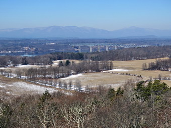
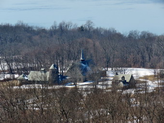 The tower is an International Derrick which was moved from South Carolina and erected at Ferncliff a few years ago. We took pictures from the ground of the tower and then leashed Sheila to tree before climbing the tower. Sheila will try to follow us and does a pretty good job of climbing up and down. These steps were open metal so I thought it was better she stay on the ground. As we climbed toward the top of the tower, Cindy decided to stop abbot three-quarters of the way up. I continued to the top and found the cab open. The views to the east were OK but those to the west were outstanding. The Hudson River was below with the bridge clearly visible. Near the tower, on the eastern shore, were some fields separated by lines of trees. I took a lot of pictures in this direction at various zooms. There were also some interesting buildings. The main building had what looked like a steeple but the rest of the building looked more like a barn. On the western shore were some industrial buildings. In the background were the northeastern Catskills which certainly looked imposing from the tower. It was a little colder above the tree line so I headed back down. We decided to try to take the West Tower Trail back to form a loop since we knew we would not be hiking too much. We hiked away ROM the tower in the opposite direction we came and continued to hike without seeing the turn for the loop trail. We did see a sign that said there was private land ahead and that we should take the loop trail. We continued along expecting to find it but soon began to see private residences. I was very disappointed in the poor trail markings. We turned around and retraced our steps and found the West Tower trail with no marking for a turn. Most of the trails continued to have a few marking here and there but they were spotty at best. The trail wound around a little but soon a sign advised us to take the Circle Trail back. This trail passed through some wet areas but we were soon on the opposite side of the pond we had seen earlier. We walked around the pond and I stopped to take a few pictures of the pond and pavilions. We then retraced our steps to the car. The total hike was 2.2 miles. I know that this area is a favorite when the weather gets warmer and I was glad to see it when nobody else was around! We were ready to head south to Stissing Mountain for our second hike of the day.
![]()
![]()
![]()
![]() On Wednesday, March 8th I wanted to get out for a hike after I returned home from teaching chemistry for the day. Teaching has been fun and rewarding but also tiring but I knew I needed to get outside. By the time I returned home at 3:30 PM the temperature was still only 18 degrees with a stiff breeze blowing. I decided to just go across the street to Round Top as we could easily return if we were too cold. I put on a long-sleeved base layer and wore a Patagonoa medium weight wool top. I put on a pair of tights underneath my Columbia Omniheat hiking pants. These have a reflective lining and are heavier than my "go to" Railriders pants. The pants have Velcro closures at the ankles which means gaiters are not usually needed until the snow gets deeper. I donned my Mammut hoody which has enough zippers to dump heat if needed but blocks the wind well. I put on a heavier hat and gloves. I wore my Salomon B52 winter boots which are insulated against the cold. I grabbed a pair of Leki poles with external locks that I have been using lately. I decided to leave my microspikes at home as I hoped there would be little snow and ice. At 3:55 PM we walked out the door. I grabbed Sheila's leash from the car and we walked up the driveway. She pulled me up the driveway knowing exactly where we were going. The driveway was icy in places which we carefully worked around. We crossed the street with Sheila on her leash and walked to the back of the church with the wind making me feel very cold. We started the walk up the steepest hill behind the church. The hill had only a little ice but did have a dusting of snow. The hill is short but gets the circulation pumping as is the steepest and longest climb on the "trail." Sheila helped me along by pulling me up the hill. When we got to the top of the hill, we paused for a moment to take in the view before turning left at the trailhead. I let Sheila off her leash, and she began to explore the trail with her nose. As we followed the trail, I noticed that there was more snow than I thought there might be.
On Wednesday, March 8th I wanted to get out for a hike after I returned home from teaching chemistry for the day. Teaching has been fun and rewarding but also tiring but I knew I needed to get outside. By the time I returned home at 3:30 PM the temperature was still only 18 degrees with a stiff breeze blowing. I decided to just go across the street to Round Top as we could easily return if we were too cold. I put on a long-sleeved base layer and wore a Patagonoa medium weight wool top. I put on a pair of tights underneath my Columbia Omniheat hiking pants. These have a reflective lining and are heavier than my "go to" Railriders pants. The pants have Velcro closures at the ankles which means gaiters are not usually needed until the snow gets deeper. I donned my Mammut hoody which has enough zippers to dump heat if needed but blocks the wind well. I put on a heavier hat and gloves. I wore my Salomon B52 winter boots which are insulated against the cold. I grabbed a pair of Leki poles with external locks that I have been using lately. I decided to leave my microspikes at home as I hoped there would be little snow and ice. At 3:55 PM we walked out the door. I grabbed Sheila's leash from the car and we walked up the driveway. She pulled me up the driveway knowing exactly where we were going. The driveway was icy in places which we carefully worked around. We crossed the street with Sheila on her leash and walked to the back of the church with the wind making me feel very cold. We started the walk up the steepest hill behind the church. The hill had only a little ice but did have a dusting of snow. The hill is short but gets the circulation pumping as is the steepest and longest climb on the "trail." Sheila helped me along by pulling me up the hill. When we got to the top of the hill, we paused for a moment to take in the view before turning left at the trailhead. I let Sheila off her leash, and she began to explore the trail with her nose. As we followed the trail, I noticed that there was more snow than I thought there might be.
At the first trail junction, I followed Sheila as she continued straight ahead up the hill toward the lookout. I followed the yellow blazes up to the spur trail to the viewpoint and walked to the top of the hill. As we made the turn to follow the trail uphill toward the next trail junction there was several inches of snow. At the junction, we turned right to follow the yellow trail along the base of Round Top. The snow was soft and fluffy over a slightly harder, packed base. At the next trail junction, we turned left on the blue trail and walked up toward the summit of Round Top. This part of the trail faces east and south but still had a few inches of fresh snow. Soon we were walking across the summit plateau. We started down the steeper side where I found the going difficult as the layer of fresh snow hid several patches of ice and hard-packed snow. Once we got to the yellow trail, we turned left and walked to the trail junction again. This time we turned right and followed the trail down to the woods road. We walked downhill on the woods road to the first trail junction finding one tree across the trail. I was still feeling fresh so we turned around to do another figure 8 in the opposite direction. We started back up the more gentle slope we had just descended. We followed the yellow blazes up the woods road to the next trail junction where we turned left to walk along the base of Round Top. At the next junction with the blue trail, we turned right and walked up the steepest hill on the trail. Ascending this steeper section with its icy patches was challenging in spots. We finally made the summit of Round Top without a problem. Sheila was running around off the trail investigating various animal tracks seemingly unfazed by the cold weather. We walked across the summit and down the hill to the yellow trail. We turned right to again walk along the base of Round Top. At the next trail junction we turned left to walk down to the lookout. At the lookout we turned left and followed the yellow blazes on the trail back to the first trail junction. We continued straight ahead on the yellow trail to the trailhead. We walked down the cemetery hill under overcast skies. At the base of the hill, I put Sheila on her leash and we walked back to our driveway. It was 5:00 PM and we had hiked 1.8 miles in just over an hour.
![]()
![]()
![]()
![]()
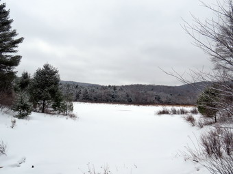
![]() On Saturday, March 2nd, I was ready to get a longer hike in after teaching for a full week. When I woke up, I noticed Sheila was "coughing" and I could not determined whether it was a respiratory or digestive problem. The problem continued for some time problem and I was becoming concerned although Sheila seemed to be doing fine. I was trying to decided whether to take her to the et or not when the coughing became less frequent and eventually disappeared. I began to think we should try hiking but over a shorter distance. I decided to go to Frick Pond and hike a shorter loop to make sure Sheila was aright. I asked Cindy if she wanted to go along and she agreed. Sheila would like to go out everyday and was more than ready to go for a hike. Around 9:15 AM I began to get ready to leave. I put on a long-sleeved base layer and wore my Mammut pullover which is heavier than most others I own. I put on a pair of Columbia Omniheat hiking pants which have a reflective lining and are heavier than my "go to" Railriders pants. The pants have Velcro closures at the ankles which means gaiters are not usually needed until the snow gets deeper. I donned my Mammut hoody which has enough zippers to dump heat if needed. I put on a hat and heavier gloves. I wore my Salomon B-52 boots which are old but fit well and are the boot I prefer for winter. I did put on a pair of OR Crocodile gaiters to fend off the snow and keep my lower legs warm. I grabbed a pair of Leki poles with external locks that I have been using lately to go with the snowshoes. When I looked at the temperature, it was still right around freezing. I got our gear in the car and put Sheila in the backseat before heading out the driveway. We stopped to check the mail and then I headed out DeBruice Road. I turned left on the Mongaup Pond Road to head toward the Frick Pond trailhead. I stayed to the left where the road spilt and headed up Beech Mountain Road to the trailhead. Both parking areas had been plowed at some time but the snow had drifted in and there was some frozen snow in both lots. There were two pickup trucks parked in the larger lot. They had a light covering of snow so Assumed they had been there overnight. The temperature was only 28 degrees but there was no breeze. We both put on our microspikes and I set my GPS before starting out on the woods road toward the trail register. There was some ice and hard-packed snow as well as the newly-fallen dusting of powder. The woods road from the register out to Gravestone Junction had snow and ice but very little standing or running water. We stopped twice along so that I could take some pictures. There was still some snow encasing the branches on the trees. We stayed to the left at Gravestone Junction and walked down the hill to Frick Pond. The view of the pond was much the same as always but Flynn's Point had a covering of frozen snow on the trees. I decided to atop and take some pictures. After taking some shots, I packed up and we headed over the bridge to continue our hike. Sheila has not been out in several days and she was dashing around and really enjoying herself. She was not showing any signs of impairment from her earlier problems.
On Saturday, March 2nd, I was ready to get a longer hike in after teaching for a full week. When I woke up, I noticed Sheila was "coughing" and I could not determined whether it was a respiratory or digestive problem. The problem continued for some time problem and I was becoming concerned although Sheila seemed to be doing fine. I was trying to decided whether to take her to the et or not when the coughing became less frequent and eventually disappeared. I began to think we should try hiking but over a shorter distance. I decided to go to Frick Pond and hike a shorter loop to make sure Sheila was aright. I asked Cindy if she wanted to go along and she agreed. Sheila would like to go out everyday and was more than ready to go for a hike. Around 9:15 AM I began to get ready to leave. I put on a long-sleeved base layer and wore my Mammut pullover which is heavier than most others I own. I put on a pair of Columbia Omniheat hiking pants which have a reflective lining and are heavier than my "go to" Railriders pants. The pants have Velcro closures at the ankles which means gaiters are not usually needed until the snow gets deeper. I donned my Mammut hoody which has enough zippers to dump heat if needed. I put on a hat and heavier gloves. I wore my Salomon B-52 boots which are old but fit well and are the boot I prefer for winter. I did put on a pair of OR Crocodile gaiters to fend off the snow and keep my lower legs warm. I grabbed a pair of Leki poles with external locks that I have been using lately to go with the snowshoes. When I looked at the temperature, it was still right around freezing. I got our gear in the car and put Sheila in the backseat before heading out the driveway. We stopped to check the mail and then I headed out DeBruice Road. I turned left on the Mongaup Pond Road to head toward the Frick Pond trailhead. I stayed to the left where the road spilt and headed up Beech Mountain Road to the trailhead. Both parking areas had been plowed at some time but the snow had drifted in and there was some frozen snow in both lots. There were two pickup trucks parked in the larger lot. They had a light covering of snow so Assumed they had been there overnight. The temperature was only 28 degrees but there was no breeze. We both put on our microspikes and I set my GPS before starting out on the woods road toward the trail register. There was some ice and hard-packed snow as well as the newly-fallen dusting of powder. The woods road from the register out to Gravestone Junction had snow and ice but very little standing or running water. We stopped twice along so that I could take some pictures. There was still some snow encasing the branches on the trees. We stayed to the left at Gravestone Junction and walked down the hill to Frick Pond. The view of the pond was much the same as always but Flynn's Point had a covering of frozen snow on the trees. I decided to atop and take some pictures. After taking some shots, I packed up and we headed over the bridge to continue our hike. Sheila has not been out in several days and she was dashing around and really enjoying herself. She was not showing any signs of impairment from her earlier problems.
 The trail on the west side of the pond was icy in places but the temperature was increasing making snow clump on the bottom of our spikes. At the next trail junction we stayed to the left to follow the Quick Lake Trail through the "Spruce Tunnel" to Iron Wheel Junction. I definitely felt that the spikes were becoming more of a problem than an asset as I had to stop frequently to use my poles to knock the snow off. There was still quite a bit of snow in the woods away from the trail averaging from 4 to 6 inches. We stopped at the small stream which was running with water. I took some shots of the stream and the trail before packing up to move on. We could not cross where the trail crossed so we walked upstream to cross where the stream is narrower. We continued up to Iron Wheel Junction still having problems with no clumping on our spikes. When we arrived at Iron Wheel Junction, we stopped to get a drink and a bar. We could see that the trail had been used by snowmobiles and could hear some machines on the Logger's Loop toward Times Square. As we were stopped several machines went through the junction. I took a few shots and then we turned right to get on the Logger's Loop to head toward Times Square. The sign told us that Times Square was about 1.2 miles away but I knew that we would go through a series of ups and downs along the way before hitting the highest point at 1.8 miles. Snow continued to clump on my spikes so I stopped to remove them. Cindy decided to keep her's on. Just before the highest point ion the trail, we stopped to allow another group of snowmobiles to pass us. Once we hit the high point it was all downhill to Times Square. At 2.4 miles we stopped at a small pond on the left side of the trail. I took a few pictures before we continued on the trail. We walked downhill to Times Square. At Times Square I took a quick look up the Big Rock Trail but decided to simply continue out the Logger's Loop. This part of the trail has a slight uphill but is probably the easiest way back to the parking area from Times Square. All along our hike I had been noticing the areas where we had cleared blowdowns. I also noted that there were areas that needed new trail markers which now can only be placed by the foresters. I was having no trouble walking without my spikes. We crested the small hill and started down to Gravestone Junction. Sheila alerted and I could see several tents pitched at the designated campsite on the right side of the trail near the privy. They were loud and seemed to be having a good time. We passed by the campers and continued toward Gravestone Junction. We turned left on the Quick Lake Trail and began the walk back to the car. The walk went quickly and we were back at the car at noon having taken 2 hours and 15 minutes to hike 3.7 miles with an elevation gain of only 385 feet. The temperature was still right around freezing.
![]()
![]()
![]()
![]()
![]() On Saturday, February 23rd, I had wanted to get out on a longer hike as early in the day as possible. I had to time a basketball playoff game which might be moved up to 2:00 PM due to another approaching ice storm. In addition, I wanted to get out while the snow was still frozen as I planned to wear spikes and not snowshoes. The recent warmer weather and rain had been followed by a freeze leaving a small amount of very hard snow. My intent was to go to the Frick and Hodge Pond areas and visit both ponds in some kind of loop. I asked Cindy if she wanted to go and she agreed and we hurried to get to the trailhead by 10:00 AM. I started to get ready with Sheila underfoot making sure that I knew she wanted to go. I put on a long-sleeved base layer and wore my Mammut pullover which is heavier than most others I own. I put on a pair of tights underneath my Columbia Omniheat hiking pants. These have a reflective lining and are heavier than my "go to" Railriders pants. The pants have Velcro closures at the ankles which means gaiters are not usually needed until the snow gets deeper. I donned my Mammut hoody which has enough zippers to dump heat if needed. I put on a heavier hat and gloves. I wore my Salomon B52 winter boots which are all leather and seem to be waterproof with sufficient insulation. I decided to put on a pair of OR Crocodile gaiters. I grabbed a pair of Leki poles with external locks that I have been using lately. I made sure my microspikes were in my pack as I expected to use them at some time. At 9:30 AM we walked out the door, got in the car and started out DeBruce Road toward Frick Pond. After 6 miles, at Mongaup Pond Road, I turned left and continued to follow the road bearing left onto Beech Mountain Road at the fork. When we arrived in the parking area, there were no cars in the parking lots. I parked in the smaller lot as I planned to start at the beginning of the Flynn Trail. The temperature was 28 degrees. We both decided to put on our spikes as the Flynn Trail looked untouched and plenty icy. I finished getting ready by setting my GPS unit. We crossed the road and started our hike on the Flynn Trail at 9:50 AM. The trail was unbroken and we were sinking in slightly despite the heavy crust. This made walking arduous as our poles were also sinking in a catching on the crust. At the end of the trail through the woods we turned right on the old Beech Mountain Road and continued to follow the Flynn trail uphill.
On Saturday, February 23rd, I had wanted to get out on a longer hike as early in the day as possible. I had to time a basketball playoff game which might be moved up to 2:00 PM due to another approaching ice storm. In addition, I wanted to get out while the snow was still frozen as I planned to wear spikes and not snowshoes. The recent warmer weather and rain had been followed by a freeze leaving a small amount of very hard snow. My intent was to go to the Frick and Hodge Pond areas and visit both ponds in some kind of loop. I asked Cindy if she wanted to go and she agreed and we hurried to get to the trailhead by 10:00 AM. I started to get ready with Sheila underfoot making sure that I knew she wanted to go. I put on a long-sleeved base layer and wore my Mammut pullover which is heavier than most others I own. I put on a pair of tights underneath my Columbia Omniheat hiking pants. These have a reflective lining and are heavier than my "go to" Railriders pants. The pants have Velcro closures at the ankles which means gaiters are not usually needed until the snow gets deeper. I donned my Mammut hoody which has enough zippers to dump heat if needed. I put on a heavier hat and gloves. I wore my Salomon B52 winter boots which are all leather and seem to be waterproof with sufficient insulation. I decided to put on a pair of OR Crocodile gaiters. I grabbed a pair of Leki poles with external locks that I have been using lately. I made sure my microspikes were in my pack as I expected to use them at some time. At 9:30 AM we walked out the door, got in the car and started out DeBruce Road toward Frick Pond. After 6 miles, at Mongaup Pond Road, I turned left and continued to follow the road bearing left onto Beech Mountain Road at the fork. When we arrived in the parking area, there were no cars in the parking lots. I parked in the smaller lot as I planned to start at the beginning of the Flynn Trail. The temperature was 28 degrees. We both decided to put on our spikes as the Flynn Trail looked untouched and plenty icy. I finished getting ready by setting my GPS unit. We crossed the road and started our hike on the Flynn Trail at 9:50 AM. The trail was unbroken and we were sinking in slightly despite the heavy crust. This made walking arduous as our poles were also sinking in a catching on the crust. At the end of the trail through the woods we turned right on the old Beech Mountain Road and continued to follow the Flynn trail uphill.
 The snow wasn't deep and I was able to see a slight hint of the track I had left earlier. Sheila started to follow that track and we followed her. When she began to follow animal tracks, I directed her to stay in the middle of the woods road and follow the existing track. I am no longer surprised when Sheila does exactly what I ask her as she is a great trail dog. We passed thorough the tunnel that we had cut in a big spruce tree that had fallen across the trail. The walking was tiring and it wasn't the kind of snow where Sheila could break a trail. We stopped every now and then to catch our breath as sinking into the snow and then lifting our feet was tiring. We like to talk when we hike but it was impossible to hear each other over the crunching of the snow so we mostly kept to ourselves. During one stop I took some pictures of the unbroken snow and of Sheila and Cindy on the trail. It took almost an hour to hike a little over one mile to the area where there is a clearing on the eastern side of the trail. We were both tired and knew there was still more than half a mile to the Big Rock Trail. My plan was to hike to the trail junction and then out and around Hodge Pond. We would then hike back to the Big Rock Trail and down to Times Square. I was pretty sure that this trail would be packed by snowmobiles. It seemed like a long haul to the junction with the Big Rock Trail. After 1.7 miles of uphill hiking, we reached the Big Rock Trail after almost and hour and 15 minutes of walking. The trail was well-packed by snowmobiles. I was ready to try the trip to Hodge Pond but Cindy was not. I was a little disappointed but I was tired also and time was not on my side. We turned left and started downhill on the packed snow which was a real pleasure! Sheila seemed to agree as she ran ahead and then doubled back at a furious pace despite sinking into the hard crust. We made good time heading for Times Square. There are three separate areas where the trail levels and then descends and again but I was ready for these.
 When we reached Times Square, I looked around to see if there were snowmobile tracks on the Logger's Loop to the left or straight ahead on the Big Rock Trail. Fortunately, the only tracks I saw were tracks from hikers! We continued straight ahead on the Big Rock Trail around the back of Frick Pond keeping a fast pace. After a short distance, Sheila alerted and we saw three hikers coming toward us. We said "hello" and I noticed all three were wearing spikes. We cross both of the bridges over the small inlet streams to Frick Pond. We stopped in the woods and I took a few pictures of the trail through the spruce forest. We walked across the wooden causeways which were covered in snow but showed evidence that many people had been using them. We continued over the rest of the Big Rock Trail out to the Quick Lake Trail. We turned left on the Quick Lake Trail which was also packed. It was a short walk to the bridge across the outlet of Frick Pond. As we approached, I could see a couple coming across the bridge so I put Sheila on her leash. As we passed and greeted each other, I noticed these hikers also were wearing spikes. Even though I have taken many pictures from the bridge, I couldn't resist stopping to take a few more. I took shots of the pond and Beech Mountain including some interesting clouds. I packed up and we headed up the hill. We passed through Gravestone Junction and continued on the woods road back toward the parking area. This trail is usually wet but there were only a few trickles of water with the rest frozen solid. As we approached the register box, there were two more couples signing in and they also wore spikes! We continued straight ahead following the woods road back out to the parking area. The walk was short and we emerged in the small parking area where there were several cars now parked. We walked over to the car after hiking 4 miles in 2 hours and 15 minutes with a vertical gain of 720 feet. The temperature was 28 degrees, the same as the beginning of the hike. As we drove away some sleet began to hit the windshield.
![]()
![]()
![]()
![]() On Wednesday, February 20th an announcement was made early in the morning that school would close just after noon for an impending ice storm. I immediately began to plan a trip to Frick and Hodge Ponds providing it was still possible when I got home. I returned home just after 12:30 PM and it was still nice enough to take a quick trip to Frock Pond. I asked Cindy if she would like to go hiking. She said "Yes" but suggested going across the street to Round Top. I really did not want to do this but felt locked into it. I reluctantly agreed and started getting ready for a hike I had done dozens of times. The temperature outside was in the high 20's but it felt raw and colder than that. I started to get ready with Sheila encouraging me at very turn. I put on a long-sleeved base layer under my Mammut pullover which is heavier than most others I own. I put on a pair of tights underneath my Columbia Omniheat hiking pants which have a reflective lining. The pants have Velcro closures at the ankles which means gaiters are not usually needed until the snow gets deeper. I donned my Mammut hoody which has enough zippers to dump heat if needed. I put on a heavier hat and gloves. I wore my Salomon B52 winter boots which are all leather and seem to be waterproof with sufficient insulation. We decided that there was not enough snow for snowshoes and that spikes would also not be needed. I grabbed a pair of Leki poles with external locks that I have been using lately. At 1:00 PM we walked out the door to start the hike. I grabbed Sheila's leash from the car and we walked up the driveway. I decided we would try to do at least two figure 8's which might be enough given the situation. I aimed to hike for about an hour. Sheila was happy to get out as we headed down the driveway and across the street. We crossed the street and walked across the field to the back of the church. I was surprised that there was only a couple of inches of snow in the field and that was frozen hard as a rock. We began the ascent of the steepest hill behind the church which was almost completely bare of snow and ice. The hill is short but gets the circulation pumping and is the steepest and longest climb on the "trail." Sheila helped me along by pulling me up the hill.
On Wednesday, February 20th an announcement was made early in the morning that school would close just after noon for an impending ice storm. I immediately began to plan a trip to Frick and Hodge Ponds providing it was still possible when I got home. I returned home just after 12:30 PM and it was still nice enough to take a quick trip to Frock Pond. I asked Cindy if she would like to go hiking. She said "Yes" but suggested going across the street to Round Top. I really did not want to do this but felt locked into it. I reluctantly agreed and started getting ready for a hike I had done dozens of times. The temperature outside was in the high 20's but it felt raw and colder than that. I started to get ready with Sheila encouraging me at very turn. I put on a long-sleeved base layer under my Mammut pullover which is heavier than most others I own. I put on a pair of tights underneath my Columbia Omniheat hiking pants which have a reflective lining. The pants have Velcro closures at the ankles which means gaiters are not usually needed until the snow gets deeper. I donned my Mammut hoody which has enough zippers to dump heat if needed. I put on a heavier hat and gloves. I wore my Salomon B52 winter boots which are all leather and seem to be waterproof with sufficient insulation. We decided that there was not enough snow for snowshoes and that spikes would also not be needed. I grabbed a pair of Leki poles with external locks that I have been using lately. At 1:00 PM we walked out the door to start the hike. I grabbed Sheila's leash from the car and we walked up the driveway. I decided we would try to do at least two figure 8's which might be enough given the situation. I aimed to hike for about an hour. Sheila was happy to get out as we headed down the driveway and across the street. We crossed the street and walked across the field to the back of the church. I was surprised that there was only a couple of inches of snow in the field and that was frozen hard as a rock. We began the ascent of the steepest hill behind the church which was almost completely bare of snow and ice. The hill is short but gets the circulation pumping and is the steepest and longest climb on the "trail." Sheila helped me along by pulling me up the hill.
When we got to the top of the hill, we started on the trail by turning left at the trailhead. The sun on the trailhead had melted all of the snow down to bare ground. I let Sheila off her leash, and she began to explore the trail with her nose. As we followed the trail, I noticed there was a covering of snow over a layer of harder packed snow and ice. and that there were footprints in it. I am always happy to see that someone else uses the trails. At the first trail junction, we followed Sheila as she turned right on the woods road which is the shallower approach to the trail system. We continued to follow the yellow trail to the first junction where we turned left and followed it to the next trail junction. There was one blowdown across the trail which would require an axe to clear. There wasn't much snow in the woods either and it was well-packed. My conclusion was that spikes would probably have been a good idea! At the second junction with the blue trail, we turned right and started up the steep blue trail that leads over the summit of Round Top. This section of the trail faces west and north so there was more snow and ice which made the going slippery. I was able to get a grip by planting my feet and poles but some sections were tricky! We walked across the flat summit of Round Top and started down the other side. Descending on the snow and ice proved to be a problem without any traction. Soon we were back at the yellow trail. We turned right and walked the yellow trail to the next trail junction. Here we turned left and followed the yellow trail downhill to the lookout. There wasn't much to see at the lookout so we continued on the trail. We followed the yellow trail as it turned left and descended the hill to the first trail junction. The walk had gone quickly, so we turned around and started back up the hill back to the lookout. Sometimes Sheila resists another loop but this time she was in the lead. We followed the yellow trail uphill toward the lookout and turned right to continue up to the next trail junction with the blue trail. Along the way a few spots were difficult to navigate. At the trial junction, we turned right to stay on the yellow trail. At the next junction we turned left to climb the shallower side of the summit ascent. This was easier than descending but the slipping and sliding were a good workout. We again walked across the flat summit and descended the steeper trail. The hard packed snow and ice made this descent the trickiest of all but we made it to the bottom without falling. At the trail junction, we turned left and followed the yellow trail along the base of Round Top. At the next junction we turned right this time to follow the trail down to the woods road that leads out to the first trial junction. That was enough for me given the time and the impending icy weather. We turned left and walked out to the trailhead. Sheila was well-behaved and stayed with us most of the time. I put her on her leash and we walked down the cemetery hill. We walked across the field to our driveway. It was 2:15 PM and we had hiked over 2 miles in a little more than an hour.
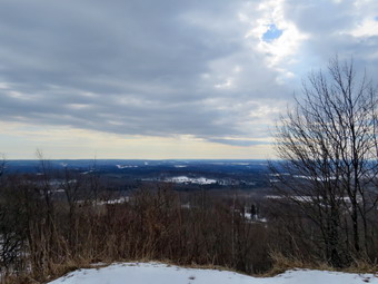
![]()
![]()
![]()
![]()
![]() On Friday, February 15th we had a day off from school for a teacher's conference. I was not required to go as I am officially a per diem substitute teacher so I decided to call Karl and ask him to bring Bryce to the house ready to hike. Some rain was forecast for the afternoon and I had not hiked for almost a week so I decided to do a local hike. I wanted to pick my paycheck up in Liberty so I thought we might go to Walnut Mountain to hike. Bryce didn't arrive until about 9:30 AM and by the time we wee ready to go it was around 10:30 AM. I was surprised when I checked the temperature and found it was in the low 40's! I knew that this would make the snow very soft but I also knew there wasn't much left after the recent rain and warmer weather. I decided against snowshoes and just left my spikes in my pack. As I began to get ready Sheila was happily dancing about. Going back to teaching full-time and coaching has pit a real dent in our ability to get out and hike! I put on a long-sleeved Mammut pullover which is heavier than most others I own but did not add a base layer. I put on my Columbia Omniheat hiking pants but did not wear tights underneath. These pants have a reflective lining and are heavier than my "go to" Railriders pants. The pants have Velcro closures at the ankles which means gaiters are not usually needed until the snow gets deeper. I donned my Mammut hoody which has enough zippers to dump heat if needed but blocks the wind well. I put on a lighter hat and gloves. I decided to wear my Salomon B52 boots which I thought would be better in the wet snow than the Vasque Talus hiking boots. I did put on a pair of OR Crocodile gaiters and grabbed a pair of Leki poles with external locks that I have been using lately. I also grabbed Bryce's polls as we headed out to the car. I put the gear in the back of the car and Sheila and Bryce in the back seat. I drove out to the Quickway and headed to the Liberty High School to pick up my check. From there I drove out Route 52 to West Lake Street and turned left. As we drove passed the West Lake Street parking area, I decided we would go to the main parking lot on Walnut Mountain Road. I turned right on Route 55 at the end of West Lake Street and drove to Walnut Mountain Road where I turned right and drove toward the parking area. The road was plowed all the way to the parking lot but the gate was locked so we parked in one of the spots outside the gate just after 11"00 AM. There were no other cars which sited my just fine! I set my GPS and we started the hike at 11:10 AM by walking around the gate and up the road to the area of the pavilion. Walnut Mountain Park offers a great variety of trails and routes including carriage roads, trails and mountain bike tracks. I chose to walk up the main carriage road that passes the pavilion on the left. We turned right and started up the hill on the wide carriage road. Immediately we found out that the soft and melting snow hid patches of ice! We walked up the hill passing several side trails until the main trail split. We continued straight ahead on the carriage road which eventually met the Walnut Loop Trail West. This trail heads south along the west side of the mountain eventually climbing along hill to a viewpoint on the right. We stopped so that I could take a few pictures right around the 1.1 mile mark. I took some shots of the trail and out across the landscape toward the west and north. I knew we would probably get to the upper lookout which has a better view. We continued to follow the carriage road as it passed through a field and then made a sharp left turn becoming the Walnut Loop Trail East. We descended the hill heading back to the elevation of the main parking area and encountering some more ice along the way. We walked through and old quarry, out to the playground and back toward the pavilion.
On Friday, February 15th we had a day off from school for a teacher's conference. I was not required to go as I am officially a per diem substitute teacher so I decided to call Karl and ask him to bring Bryce to the house ready to hike. Some rain was forecast for the afternoon and I had not hiked for almost a week so I decided to do a local hike. I wanted to pick my paycheck up in Liberty so I thought we might go to Walnut Mountain to hike. Bryce didn't arrive until about 9:30 AM and by the time we wee ready to go it was around 10:30 AM. I was surprised when I checked the temperature and found it was in the low 40's! I knew that this would make the snow very soft but I also knew there wasn't much left after the recent rain and warmer weather. I decided against snowshoes and just left my spikes in my pack. As I began to get ready Sheila was happily dancing about. Going back to teaching full-time and coaching has pit a real dent in our ability to get out and hike! I put on a long-sleeved Mammut pullover which is heavier than most others I own but did not add a base layer. I put on my Columbia Omniheat hiking pants but did not wear tights underneath. These pants have a reflective lining and are heavier than my "go to" Railriders pants. The pants have Velcro closures at the ankles which means gaiters are not usually needed until the snow gets deeper. I donned my Mammut hoody which has enough zippers to dump heat if needed but blocks the wind well. I put on a lighter hat and gloves. I decided to wear my Salomon B52 boots which I thought would be better in the wet snow than the Vasque Talus hiking boots. I did put on a pair of OR Crocodile gaiters and grabbed a pair of Leki poles with external locks that I have been using lately. I also grabbed Bryce's polls as we headed out to the car. I put the gear in the back of the car and Sheila and Bryce in the back seat. I drove out to the Quickway and headed to the Liberty High School to pick up my check. From there I drove out Route 52 to West Lake Street and turned left. As we drove passed the West Lake Street parking area, I decided we would go to the main parking lot on Walnut Mountain Road. I turned right on Route 55 at the end of West Lake Street and drove to Walnut Mountain Road where I turned right and drove toward the parking area. The road was plowed all the way to the parking lot but the gate was locked so we parked in one of the spots outside the gate just after 11"00 AM. There were no other cars which sited my just fine! I set my GPS and we started the hike at 11:10 AM by walking around the gate and up the road to the area of the pavilion. Walnut Mountain Park offers a great variety of trails and routes including carriage roads, trails and mountain bike tracks. I chose to walk up the main carriage road that passes the pavilion on the left. We turned right and started up the hill on the wide carriage road. Immediately we found out that the soft and melting snow hid patches of ice! We walked up the hill passing several side trails until the main trail split. We continued straight ahead on the carriage road which eventually met the Walnut Loop Trail West. This trail heads south along the west side of the mountain eventually climbing along hill to a viewpoint on the right. We stopped so that I could take a few pictures right around the 1.1 mile mark. I took some shots of the trail and out across the landscape toward the west and north. I knew we would probably get to the upper lookout which has a better view. We continued to follow the carriage road as it passed through a field and then made a sharp left turn becoming the Walnut Loop Trail East. We descended the hill heading back to the elevation of the main parking area and encountering some more ice along the way. We walked through and old quarry, out to the playground and back toward the pavilion.
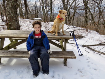 We turned left and started back up the mountain the way we had gone the first time. Bryce and I were both a little tired and warm since the sun had come out full force. This time we turned left at he trail junction and headed south on the Mountain House Overlook Trail. After a short walk uphill. We turned right and continued to climb on the Sunset Trail which loops around the mountain. At 2.25 miles we followed the trail as it turned left or south paralleling the Walnut Loop West but at a higher elevation. At the south end of this trail I wanted to turn left to climb to the summit but first we walked straight ahead to the upper lookout. This had better views than the one below so I dropped my pack and got out the camera. While I took pictures, Bryce got a drink. I took shots toward Swan Lake and noticed that the skies to the northwest were getting very dark. We retraced our steps and followed the Mountain House Trail up toward the summit of Walnut Mountain. At one time there had been a small resort hotel on the mountain with a ski area. As the trail leveled off we followed some paths to the left that headed toward the summit. There were some mountain bike tracks that went up through the rocks and we had to be careful because of the ice. We walked along the tracks and crossed a wooden bridge put in by the bike club. We stopped at Ta picnic table just below the summit. Bryce sat down and Sheila jumped up beside him. I took some shots of them and then a few of the trails and the summit. I shouldered my pack and we headed over the summit and then looped back to the path we had taken up. We walked down to a mountain bike track and followed it north for a short distance before turning right and walking out to the Mountain House Trail. We walked back to the Sunset Trail and along the way I could see a hiker with two dogs running free. I put Sheila on her leash as we turned right on the Sunset Trail and walked back out to the Mountain Overlook Trail. The hiker must have called his dogs and continued to the overlook because we never saw them again. We retraced our route back to the main carriage road and out to the pavilion. From there we walked through parking area and back out to the car. It was 1L30 Pm when we finished and we had spent 2 hours and 20 minutes hiking 3.8 miles. The elevation gain was a modest 725 feet. We were both happy we got to hike together. It was in the upper 40's at the car and as we left raindrops began to fall.
![]()
![]()
![]()
![]() On Saturday, February 9th I wanted to get out for a hike since I had not been out in a week and Sheila was giving me longing looks. The weather had alternated between good and bad but I was not able to get out during the week as I have taken on the role of chemistry teacher at Liberty. I had to think hard about the "opportunity" but decided to accept to help out the students, many of whom I know very well. The length of my assignment could be for several weeks or until the end of the year. After four days, I alternate between feeling comfortable and overwhelmed! The temperature in Livingston Manor was in the mid teens with a sustained 20 mph wind gusting to well over 30 mph. The wind chill was well below zero so I decided to wait until after I had done some chores around the house. By 10:15 AM I knew that if I waited I might not go. I asked Cindy if she wanted to go and she said "Yes". We decided to just go across the street to Round Top as we could easily return if we were too cold. I put on a long-sleeved base layer and wore my Mammut pullover which is heavier than most others I own. I put on a pair of tights underneath my Columbia Omniheat hiking pants. These have a reflective lining and are heavier than my "go to" Railriders pants. The pants have Velcro closures at the ankles which means gaiters are not usually needed until the snow gets deeper. I donned my Mammut hoody which has enough zippers to dump heat if needed but blocks the wind well. I put on a heavier hat and gloves. I wore my Vasque Talus hiking boots which are bore comfortable than most winter boots. I grabbed a pair of Leki poles with external locks that I have been using lately but found the tip on one pole was broken. I grabbed another pair. Cindy and I decided we would take our microspikes as there had been packed snow on the trail and then rain which had frozen. I decided to leave my pack home as the snow had mostly disappeared. At 10:45 AM we walked out the door. I grabbed Sheila's leash from the car and we walked up the driveway. She pulled me up the driveway knowing exactly where we were going. There was a large patch of ice at the end of the driveway which we carefully worked around. We crossed the street with Sheila on her leash and walked to the back of the church with the wind making us feel very cold. We started the walk up the steepest hill behind the church. The hill had no ice or snow and is short but gets the circulation pumping as is the steepest and longest climb on the "trail." Sheila helped me along by pulling me up the hill. When we got to the top of the hill, we paused for a moment to take in the view before turning left at the trailhead. I let Sheila off her leash, and she began to explore the trail with her nose. As we followed the trail, I noticed that there was almost no snow and only a few paces of ice.
On Saturday, February 9th I wanted to get out for a hike since I had not been out in a week and Sheila was giving me longing looks. The weather had alternated between good and bad but I was not able to get out during the week as I have taken on the role of chemistry teacher at Liberty. I had to think hard about the "opportunity" but decided to accept to help out the students, many of whom I know very well. The length of my assignment could be for several weeks or until the end of the year. After four days, I alternate between feeling comfortable and overwhelmed! The temperature in Livingston Manor was in the mid teens with a sustained 20 mph wind gusting to well over 30 mph. The wind chill was well below zero so I decided to wait until after I had done some chores around the house. By 10:15 AM I knew that if I waited I might not go. I asked Cindy if she wanted to go and she said "Yes". We decided to just go across the street to Round Top as we could easily return if we were too cold. I put on a long-sleeved base layer and wore my Mammut pullover which is heavier than most others I own. I put on a pair of tights underneath my Columbia Omniheat hiking pants. These have a reflective lining and are heavier than my "go to" Railriders pants. The pants have Velcro closures at the ankles which means gaiters are not usually needed until the snow gets deeper. I donned my Mammut hoody which has enough zippers to dump heat if needed but blocks the wind well. I put on a heavier hat and gloves. I wore my Vasque Talus hiking boots which are bore comfortable than most winter boots. I grabbed a pair of Leki poles with external locks that I have been using lately but found the tip on one pole was broken. I grabbed another pair. Cindy and I decided we would take our microspikes as there had been packed snow on the trail and then rain which had frozen. I decided to leave my pack home as the snow had mostly disappeared. At 10:45 AM we walked out the door. I grabbed Sheila's leash from the car and we walked up the driveway. She pulled me up the driveway knowing exactly where we were going. There was a large patch of ice at the end of the driveway which we carefully worked around. We crossed the street with Sheila on her leash and walked to the back of the church with the wind making us feel very cold. We started the walk up the steepest hill behind the church. The hill had no ice or snow and is short but gets the circulation pumping as is the steepest and longest climb on the "trail." Sheila helped me along by pulling me up the hill. When we got to the top of the hill, we paused for a moment to take in the view before turning left at the trailhead. I let Sheila off her leash, and she began to explore the trail with her nose. As we followed the trail, I noticed that there was almost no snow and only a few paces of ice.
At the first trail junction, we followed Sheila as she continued straight ahead up the hill toward the lookout. We followed the yellow blazes up to the spur trail to the viewpoint and walked to the top of the hill. As we made the turn to follow the trail uphill toward the next trail junction there was several inches of packed snow. We walked for a short distance and then put on our microspikes as we could see the snow covering the trail up to the summit. At the junction, we turned right to follow the yellow trail along the base of Round Top. The snow was hard and crunchy and having the spikes on made us more confident. At the next trail junction, we turned left on the blue trail and walked up toward the summit of Round Top. This part of the trail faces east and south and had almost no snow or ice. Soon we were walking across the summit plateau. We started down the steeper side where I was partially glad we had worn the spikes. The trail had ice and snow in abundance. Once we got to the yellow trail, we turned left and walked to the trail junction again. This time we turned right and followed the trail down to the woods road. We walked downhill on the woods road to the first trail junction finding one tree across the trail. I was still feeling fresh so I asked Cindy if she would like to do another figure 8 in the opposite direction. When she said "Yes", we turned around and started back up the more gentle slope we had just descended. We followed the yellow blazes up the woods road to the next trail junction where we turned left to walk along the base of Round Top. At the next junction with the blue trail, we turned right and walked up the steepest hill on the trail. I appreciated having the spikes to ascend this section as they allowed a sure grip on the iciest parts. We both had good traction and easily made the summit of Round Top without a problem. Sheila was running around off the trail investigating various animal tracks seemingly unfazed by the cold weather. We walked down the hill to the yellow trail and turned right to again walk along the base of Round Top. At the next trail junction we turned left to walk down to the lookout. At the lookout we turned left and followed the yellow blazes on the trail back to the first trail junction. We continued straight ahead on the yellow trail to the trailhead. I took off my spikes but Cindy left hers on. We walked down the cemetery hill under partly sunny skies. At the base of the hill, I put Sheila on her leash and we walked back to our driveway. It was 11:50 PM and we had hiked 1.8 miles in just over an hour.
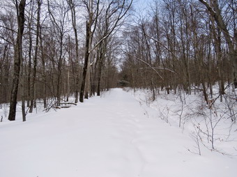
![]()
![]()
![]()
![]()
![]() On Saturday, February 2nd, I had wanted to get out early and hike Cabot Mountain or maybe even a 3500 foot peak. At 6:00 AM the temperature was -12 degrees which I knew was too cold for Sheila and too cold for me. I did some work around the house and waited until noon when the thermometer had made it all the way up to 24 degrees with some blue skies and sun. I knew it was too late to tacks what I had wanted but that Frick Pond had plenty of snow after the last storm dropped at least ten inches. I started to get ready with Sheila underfoot making sure that I knew she wanted to go. I put on a long-sleeved base layer and wore my Mammut pullover which is heavier than most others I own. I put on a pair of tights underneath my Columbia Omniheat hiking pants. These have a reflective lining and are heavier than my "go to" Railriders pants. The pants have Velcro closures at the ankles which means gaiters are not usually needed until the snow gets deeper. I donned my Mammut hoody which has enough zippers to dump heat if needed. I put on a heavier hat and gloves. I wore my Salomon B52 winter boots which are all leather and seem to be waterproof with sufficient insulation. I decided to put on a pair of OR Crocodile gaiters. I grabbed a pair of Leki poles with external locks that I have been using lately. I decided to wear my Tubbs Alp Flex VTR snowshoes with the Boa binding. This binding uses a thin steel cable system and a ratchet which tightens it to give a custom fit and a secure binding. These snowshoes also have a televator to elevate the hiker's heel on ascents. This is a feature that you didn't know you needed until you try it and then it is hard to live without it! I made sure my microspikes were in my pack although I was sure I would not need them. At 12:25 PM we walked out the door, got in the car and started out DeBruce Road toward Frick Pond. After 6 miles, at Mongaup Pond Road, I turned left and continued to follow the road bearing left onto Beech Mountain Road at the fork. When we arrived in the parking area, there were two cars in the large lot. The smaller lot where I usually park was block by a large pickup that was pulled across the front of the lot with two people sitting in it. I signaled and waited for them to move but they just sat there! I pulled in front of them and parked and they eventually pulled away. I parked in the smaller lot as I planned to start at the beginning of the Flynn Trail. The temperature was 28 degrees. I got out my snowshoes and starts to put them on and noticed a slight breeze was blowing. As I was getting ready a young dog started barking at the cabin at the end of the road and then started to approach us. The owner was calling the dog which was paying no attention. Fortunately the dog was friendly but I was annoyed by the inconsiderate owner. The same thing happened the last time we hike at Frick Pond so I concluded the owner is a slow learner. The owner tried to get a hold on his dog but could not. I finished getting ready by setting my GPS unit. We crossed the road and started our hike on the Flynn Trail at 12:45 PM. The trail was unbroken and there was at least 10 inches of fresh powder. The loose dog was still bouncing around us and a comment from the owner seemed to indicate I should do something about his problem. We walked up the Flynn Trail toward the woods road that ascends the hill. Near the end of the trail, I gave up and walked out to meet the owner since that was the only way he was going to get his dog to come to him. I was annoyed since I knew that this would continue to happen. We turned around and walked up the woods road and through the gate.
On Saturday, February 2nd, I had wanted to get out early and hike Cabot Mountain or maybe even a 3500 foot peak. At 6:00 AM the temperature was -12 degrees which I knew was too cold for Sheila and too cold for me. I did some work around the house and waited until noon when the thermometer had made it all the way up to 24 degrees with some blue skies and sun. I knew it was too late to tacks what I had wanted but that Frick Pond had plenty of snow after the last storm dropped at least ten inches. I started to get ready with Sheila underfoot making sure that I knew she wanted to go. I put on a long-sleeved base layer and wore my Mammut pullover which is heavier than most others I own. I put on a pair of tights underneath my Columbia Omniheat hiking pants. These have a reflective lining and are heavier than my "go to" Railriders pants. The pants have Velcro closures at the ankles which means gaiters are not usually needed until the snow gets deeper. I donned my Mammut hoody which has enough zippers to dump heat if needed. I put on a heavier hat and gloves. I wore my Salomon B52 winter boots which are all leather and seem to be waterproof with sufficient insulation. I decided to put on a pair of OR Crocodile gaiters. I grabbed a pair of Leki poles with external locks that I have been using lately. I decided to wear my Tubbs Alp Flex VTR snowshoes with the Boa binding. This binding uses a thin steel cable system and a ratchet which tightens it to give a custom fit and a secure binding. These snowshoes also have a televator to elevate the hiker's heel on ascents. This is a feature that you didn't know you needed until you try it and then it is hard to live without it! I made sure my microspikes were in my pack although I was sure I would not need them. At 12:25 PM we walked out the door, got in the car and started out DeBruce Road toward Frick Pond. After 6 miles, at Mongaup Pond Road, I turned left and continued to follow the road bearing left onto Beech Mountain Road at the fork. When we arrived in the parking area, there were two cars in the large lot. The smaller lot where I usually park was block by a large pickup that was pulled across the front of the lot with two people sitting in it. I signaled and waited for them to move but they just sat there! I pulled in front of them and parked and they eventually pulled away. I parked in the smaller lot as I planned to start at the beginning of the Flynn Trail. The temperature was 28 degrees. I got out my snowshoes and starts to put them on and noticed a slight breeze was blowing. As I was getting ready a young dog started barking at the cabin at the end of the road and then started to approach us. The owner was calling the dog which was paying no attention. Fortunately the dog was friendly but I was annoyed by the inconsiderate owner. The same thing happened the last time we hike at Frick Pond so I concluded the owner is a slow learner. The owner tried to get a hold on his dog but could not. I finished getting ready by setting my GPS unit. We crossed the road and started our hike on the Flynn Trail at 12:45 PM. The trail was unbroken and there was at least 10 inches of fresh powder. The loose dog was still bouncing around us and a comment from the owner seemed to indicate I should do something about his problem. We walked up the Flynn Trail toward the woods road that ascends the hill. Near the end of the trail, I gave up and walked out to meet the owner since that was the only way he was going to get his dog to come to him. I was annoyed since I knew that this would continue to happen. We turned around and walked up the woods road and through the gate.
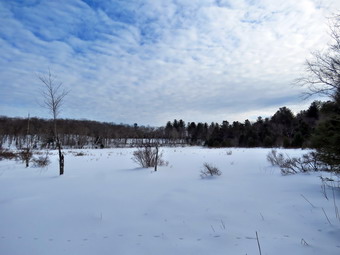 The snow was deep but I was able to see a slight hint of the track I had left earlier in the week before the last snowfall. Sheila started to follow that track and I followed her. When she began to follow animal tracks, I directed her to stay in the middle of the woods road and follow the existing track. I am no longer surprised when Sheila does exactly what I ask her as she is a great trail dog. We passed thorough the tunnel that I had cut in a big spruce tree that had fallen across the trail. The walking was tiring but following Sheila's track really helped. I stopped every now and then to catch my breath and knew that there was no way we could do the big loop I had planned. It took almost an hour to hike a little over one mile to the area where there is a clearing on the eastern side of the trail. I was tired and knew there was still more than half a mile to the Big Rock Trail. My plan was to hike down the Big Rock Trail to Times Square. I was pretty sure that this trail would be packed by snowmobiles as I could here machines running in the distance. As we walked Sheila tried to get behind me and I found it much more difficult to walk without her breaking the trail. I asked her to get out in front and she did plowing through some of the deepest snow. It seemed like a long haul to the junction with the Big Rock Trail and I considered turning around more than once. After 1.7 miles of up hill hiking is ever-deepening snow we reached the Big Rock Trail after almost and hour and a half of walking. The trail was well-packed by snowmobiles. I sighed a sigh of relief as we turned left and started downhill on the packed snow. Since the snow was packed, it was hard for me to get much of a glide but it was a pleasure going downhill! Sheila seemed to agree as she ran ahead and then doubled back at a furious pace. As we walked, Sheila alerted and I could also hear machines coming up the hill. We stepped over to the side of the trail as five machines approached. The snowmobiles immediately slowed and waved. I was surprised when they stopped. The lead rider took off his helmet and said "Hello". He was from Livingston Manor and a driver for our ambulance corps. We chatted for a few minutes before continuing in opposite directions. When Sheila and I got back on the trail we made good time heading for Times Square. There are three separate areas where the trail levels and then descends and again but I was ready for these. As we approached the base of the hill, Sheila alerted and I could see two hikers on snowshoes making the turn from the Logger's Loop onto the Big Rock Trail to make a loop around Frick Pond.
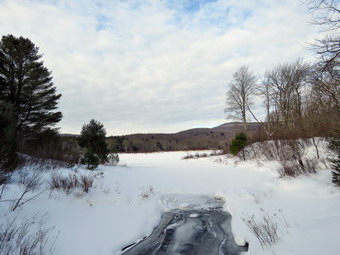 When we reached Times Square, I looked around to see if there were snowmobile tracks on the Logger's Loop to the left or straight ahead on the Big Rock Trail. Fortunately, the only tracks I saw were snowshoe tracks from hikers! We continued on the Big Rock Trail around the back of Frick Pond keeping a fast pace. We soon caught up to the other hikers who were stopped. They stepped off the trail to let us pass and we never saw them again. I stopped at the second bridge to take some pictures of the frozen stream and then stopped again just before the wooden causeways to take some more shots. As we walked, I saw a track down to the back of the pond and followed it. I put down my pack and got out my camera to take some shots. This was a nice view of the area which I could not remember photographing before. After taking a few pictures, I packed up and we walked the rest of the Big Rock Trail out to the Quick Lake Trail. We turned left on the Quick Lake Trail which was also packed and showed a track set by a cross country skier. It was a short walk to the bridge across the outlet of Frick Pond. Even though I have photographed from this spot more than any other in the Catskills, I decided to take a few more. I put down the pack and took out the camera. I took shots of the pond and Beech Mountain including some interesting clouds. I also noticed that water was flowing out of Frick Pond under the ice and tried to capture this. I also took some pictures downstream and a few of Sheila on the bridge. I packed up and headed up the hill. There was an obvious herringbone pattern where the skier had climbed up the hill. We passed through Gravestone Junction and continued on the woods road back toward the parking area. This trail is usually wet but there were only a few trickles of water with the rest frozen solid. When we reached the register box, we turned right to continue following the Quick Lake Trail. The walk was short and we emerged in the large parking area where there was one car. We walked over to the car after hiking 4 miles in 2.5 hours with a vertical gain of 684 feet. The temperature was 27 degrees showing a one degree drop since the beginning of the hike.
![]()
![]()
![]()
![]() On Tuesday, January 29th I wanted to get out for a hike even though we had been out the day before. I knew that snow was on the way followed by a bitter attic blast of cold air. I got a text from Lisa asking if I would like to go for a snowshoe hike on Round Top. I agreed to meet her at 12:30 PM at the Presbyterian Church. By noon it had already snowed a few inches and more snow was on the way. The temperature was actually a little warmer than the day before hovering around 26 degrees. I suggested to Sheila that we go "out" for a "hike" and she instantly became crazed and would not leave my sight while whining all the time. Cindy was still fighting off a cold and preferred to stay inside. I put on a long-sleeved base layer and wore my Mammut pullover which is heavier than most others I own. I put on a pair of tights underneath my Columbia Omniheat hiking pants. These have a reflective lining and are heavier than my "go to" Railriders pants. The pants have Velcro closures at the ankles which means gaiters are not usually needed until the snow gets deeper. I donned my Mammut hoody which has enough zippers to dump heat if needed. I put on a heavier hat and gloves. I wore my Salomon B52 winter boots which are all leather and seem to be waterproof with sufficient insulation. I decided to put on a pair of OR Crocodile gaiters. I grabbed a pair of Leki poles with external locks that I have been using lately. I decided to wear my Tubbs Alp Flex VTR snowshoes with the Boa binding. This binding uses a thin steel cable system and a ratchet which tightens it to give a custom fit and a secure binding. These snowshoes also have a televator to elevate the hiker's heel on ascents. This is a feature that you didn't know you needed until you try it and then it is hard to live without it! I decided to leave my pack home as I had many pictures from Round Top in the snow. At 12:25 PM we walked out the door where I put on my snowshoes. I grabbed Sheila's leash from the car and we walked up the driveway. She pulled me up the driveway knowing exactly where we were going. There was a good covering of several inches of snow and the snowshoes helped a lot except when we crossed the road. We crossed the street with Sheila on her leash and walked to the side parking area at the church where Lisa was parked. When Sheila saw Lisa, she started to pull me toward her. She gave Lisa a joyful greeting as she got ready to hike. Lisa had decided to wear only spikes instead of snowshoes. We walked to the back of the church and began the ascent of the steepest hill behind the church. The hill is short but gets the circulation pumping and is the steepest and longest climb on the "trail." Sheila helped me along by pulling me up the hill. She actually pulls harder when there is snow which has to be her Husky blood. When we got to the top of the hill, I paused for a moment to take in the view before turning left at the trailhead. I let Sheila off her leash, and she began to explore the trail with her nose. As we followed the trail, I noticed that there was more snow than the day before although not enough to require snowshoes.
On Tuesday, January 29th I wanted to get out for a hike even though we had been out the day before. I knew that snow was on the way followed by a bitter attic blast of cold air. I got a text from Lisa asking if I would like to go for a snowshoe hike on Round Top. I agreed to meet her at 12:30 PM at the Presbyterian Church. By noon it had already snowed a few inches and more snow was on the way. The temperature was actually a little warmer than the day before hovering around 26 degrees. I suggested to Sheila that we go "out" for a "hike" and she instantly became crazed and would not leave my sight while whining all the time. Cindy was still fighting off a cold and preferred to stay inside. I put on a long-sleeved base layer and wore my Mammut pullover which is heavier than most others I own. I put on a pair of tights underneath my Columbia Omniheat hiking pants. These have a reflective lining and are heavier than my "go to" Railriders pants. The pants have Velcro closures at the ankles which means gaiters are not usually needed until the snow gets deeper. I donned my Mammut hoody which has enough zippers to dump heat if needed. I put on a heavier hat and gloves. I wore my Salomon B52 winter boots which are all leather and seem to be waterproof with sufficient insulation. I decided to put on a pair of OR Crocodile gaiters. I grabbed a pair of Leki poles with external locks that I have been using lately. I decided to wear my Tubbs Alp Flex VTR snowshoes with the Boa binding. This binding uses a thin steel cable system and a ratchet which tightens it to give a custom fit and a secure binding. These snowshoes also have a televator to elevate the hiker's heel on ascents. This is a feature that you didn't know you needed until you try it and then it is hard to live without it! I decided to leave my pack home as I had many pictures from Round Top in the snow. At 12:25 PM we walked out the door where I put on my snowshoes. I grabbed Sheila's leash from the car and we walked up the driveway. She pulled me up the driveway knowing exactly where we were going. There was a good covering of several inches of snow and the snowshoes helped a lot except when we crossed the road. We crossed the street with Sheila on her leash and walked to the side parking area at the church where Lisa was parked. When Sheila saw Lisa, she started to pull me toward her. She gave Lisa a joyful greeting as she got ready to hike. Lisa had decided to wear only spikes instead of snowshoes. We walked to the back of the church and began the ascent of the steepest hill behind the church. The hill is short but gets the circulation pumping and is the steepest and longest climb on the "trail." Sheila helped me along by pulling me up the hill. She actually pulls harder when there is snow which has to be her Husky blood. When we got to the top of the hill, I paused for a moment to take in the view before turning left at the trailhead. I let Sheila off her leash, and she began to explore the trail with her nose. As we followed the trail, I noticed that there was more snow than the day before although not enough to require snowshoes.
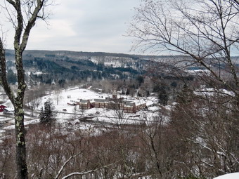 At the first trail junction, we followed Sheila as she continued straight ahead up the hill toward the lookout. We followed the yellow blazes up to the spur trail to the viewpoint and walked to the top of the hill. Town was covered in a blanket of snow and more was lightly falling. We followed the trail uphill a little toward the next trail junction. At the junction, we turned right to follow the yellow trail along the base of Round Top. The snow was fresh and no one else had been on the trail since the snow. At the next trail junction, we turned left on the blue trail and walked up toad the summit of Round Top. The snowshoes gripped well and Lisa was also having a good time with her spikes. Soon we were walking across the summit plateau. We started down the steeper side and I was able to get a glide on the snowshoes down the hill. Once we got to the yellow trail, we turned left and walked to the trail junction again. This time we turned right and followed the trail down to the woods road. We walked downhill on the woods road to the first trail junction finding one tree across the trail. I was still feeling fresh so I asked Lisa if she would like to do another figure 8 in the opposite direction. We turned around and started back up the more gentle slope we had just descended. We followed the yellow blazes up the woods road to the next trail junction where we turned left to walk along the base of Round Top. At the next junction with the blue trail, we turned right and walked up the steepest hill on the trail. We both had good traction and easily made the summit of Round Top without a problem. Sheila was running around off the trail investigating various animal tracks seemingly unfazed by the cold weather. We walked down the hill to the yellow trail and turned right to again walk along the base of Round Top. At the next trail junction we turned left to walk down to the lookout. At the lookout we turned left and followed the yellow blazes on the trail back to the first rail junction. We continued straight ahead on the yellow trail to the trailhead. We walked down the cemetery hill under partly sunny skies. At the base of the hill, I put Sheila on her leash and we walked back to Lisa's car. Sheila and I than walked across the field to our driveway. It was 1:50 PM and we had hiked 1.8 miles in an hour and 20 minutes.
![]()
![]()
![]()
![]() On Monday, January 28th I had planned to go back to Frick Pond taking snowshoes with me this time for a hike up the Flynn Trail. Saturday I had done the big loop coming down the Flynn Trail. The trail from the parking area all the way to Iron Wheel Junction had been well-packed by people or snowmobiles. When I turned right onto the Flynn Trail, I ran into between 4 and 10 inches of snow. It was tough going most of the way without snowshoes! My plans once again changed as the ambulance pager went off at 6:00 AM. We covered one call in Roscoe and then immediately had another call in the backwoods of our own district. When I got back, I was tired but knew that getting out even for a short hike would make me feel better. I decided to go across the street to hike some figure 9's on Round Top. I asked Cindy if she wanted to go but she declined as she was battling a cold. The temperature outside had finally climbed to 18 degrees with a little sun and a slight breeze. I started to get ready with Sheila encouraging me at very turn. I put on a long-sleeved base layer under my Mammut pullover which is heavier than most others I own. I put on a pair of tights underneath my Columbia Omniheat hiking pants which have a reflective lining. The pants have Velcro closures at the ankles which means gaiters are not usually needed until the snow gets deeper. I donned my Mammut hoody which has enough zippers to dump heat if needed. I put on a heavier hat and gloves. I wore my Salomon B52 winter boots which are all leather and seem to be waterproof with sufficient insulation. I decided to put on a pair of OR Crocodile gaiters. I grabbed a pair of Leki poles with external locks that I have been using lately. I put on my Tubbs Alp Flex VTR snowshoes with the Boa binding. This binding uses a thin steel cable system and a ratchet which tightens it to give a custom fit and a secure binding. These shoes also have a televator to elevate the hiker's heel on ascents. This is a feature that you didn't know you needed until you try it and then it is hard to live without it! I grabbed a pair of Leki poles with external locks that I have been using lately but chose to leave my microspikes at home. At 11:20 AM we walked out the door where I put on my snowshoes. I grabbed Sheila's leash from the car and we walked up the driveway. I decided we would try to do at least two figure 8's which might be enough given the situation. I aimed to hike for about an hour. Sheila was happy to get out as we headed down the driveway and across the street. We crossed the street and walked across the field to the back of the church. I was surprised that there was only a couple of inches of snow in the field and that was frozen hard as a rock. We began the ascent of the steepest hill behind the church which was completely bare of snow and ice. The hill is short but gets the circulation pumping and is the steepest and longest climb on the "trail." Sheila helped me along by pulling me up the hill.
On Monday, January 28th I had planned to go back to Frick Pond taking snowshoes with me this time for a hike up the Flynn Trail. Saturday I had done the big loop coming down the Flynn Trail. The trail from the parking area all the way to Iron Wheel Junction had been well-packed by people or snowmobiles. When I turned right onto the Flynn Trail, I ran into between 4 and 10 inches of snow. It was tough going most of the way without snowshoes! My plans once again changed as the ambulance pager went off at 6:00 AM. We covered one call in Roscoe and then immediately had another call in the backwoods of our own district. When I got back, I was tired but knew that getting out even for a short hike would make me feel better. I decided to go across the street to hike some figure 9's on Round Top. I asked Cindy if she wanted to go but she declined as she was battling a cold. The temperature outside had finally climbed to 18 degrees with a little sun and a slight breeze. I started to get ready with Sheila encouraging me at very turn. I put on a long-sleeved base layer under my Mammut pullover which is heavier than most others I own. I put on a pair of tights underneath my Columbia Omniheat hiking pants which have a reflective lining. The pants have Velcro closures at the ankles which means gaiters are not usually needed until the snow gets deeper. I donned my Mammut hoody which has enough zippers to dump heat if needed. I put on a heavier hat and gloves. I wore my Salomon B52 winter boots which are all leather and seem to be waterproof with sufficient insulation. I decided to put on a pair of OR Crocodile gaiters. I grabbed a pair of Leki poles with external locks that I have been using lately. I put on my Tubbs Alp Flex VTR snowshoes with the Boa binding. This binding uses a thin steel cable system and a ratchet which tightens it to give a custom fit and a secure binding. These shoes also have a televator to elevate the hiker's heel on ascents. This is a feature that you didn't know you needed until you try it and then it is hard to live without it! I grabbed a pair of Leki poles with external locks that I have been using lately but chose to leave my microspikes at home. At 11:20 AM we walked out the door where I put on my snowshoes. I grabbed Sheila's leash from the car and we walked up the driveway. I decided we would try to do at least two figure 8's which might be enough given the situation. I aimed to hike for about an hour. Sheila was happy to get out as we headed down the driveway and across the street. We crossed the street and walked across the field to the back of the church. I was surprised that there was only a couple of inches of snow in the field and that was frozen hard as a rock. We began the ascent of the steepest hill behind the church which was completely bare of snow and ice. The hill is short but gets the circulation pumping and is the steepest and longest climb on the "trail." Sheila helped me along by pulling me up the hill.
When we got to the top of the hill, we started on the trail by turning left at the trailhead. I let Sheila off her leash, and she began to explore the trail with her nose. As we followed the trail, I noticed there was a covering of snow and that there were footprints in it. I am always happy to see that someone else uses the trails. At the first trail junction, I followed Sheila as she turned right on the woods road which is the shallower approach to the trail system. We continued to follow the yellow trail to the first junction where we turned left and followed it to the next trail junction. There was one blowdown across the trail which would require an axe to clear. There wasn't much snow ion the woods either and it was well-packed. My conclusion was that spikes would have done the job but that snowshoes were satisfactory. At the second junction with the blue trail, we turned right and started up the steep blue trail that leads over the summit of Round Top. This section of the trail faces west and north so there was more snow And some was packed and slippery. I was able to get a grip with the snowshoes without a problem. We walked across the flat summit of Round Top and started down the other side. Descending on the snow and frozen ground proved to be no problem with the snowshoes which have great crampons under the forefoot and steel rails that run the length of the plastic deck. Soon we were back at the yellow trail. We turned right and walked the yellow trail to the next trail junction. Here we turned left and followed the yellow trail downhill to the lookout. There wasn't much to see at the lookout so we continued on the trail. We followed the yellow trail as it turned left and descended the hill to the first trail junction. The walk had gone quickly, so we turned around and started back up the hill back to the lookout. Sometimes Sheila resists another loop but this time she was in the lead. We followed the yellow trail uphill toward the lookout and turned right to continue up to the next trail junction with the blue trail. Here we turned right to stay on the yellow trail. At the next junction we left to climb the shallower side of the summit ascent. We again walked across the flat summit and descended the steeper trail. The hard packed snow did not allow me to get the glide that I like and can get on looser powder. At the trail junction, we turned left and followed the yellow trail along the base of Round Top. At the next junction we turned right this time. To follow the trail down to the woods road that leads out to the first trial junction. That was enough for me given the time. We turned left and walked out to the trailhead. Sheila was well-behaved and stayed with me most of the time. I put her on her leash and we walked down the cemetery hill. We walked across the field to our driveway. It was 12:35 PM and we had hiked over 2 miles in a little ore than an hour.
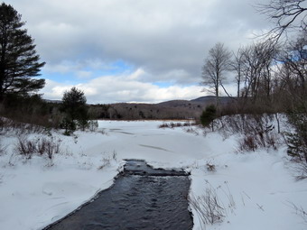
![]()
![]()
![]()
![]()
![]() On Saturday, January 26th I had planned to do a longer hike father away from home. Early in the week I thought about a 3500 foot mountain. Later, I contemplated going to Storm King or Harriman. Friday night we had a track meet at West Point and I arrived home at 1:06 AM! Shortly after that the ambulance pager went off and we went out to help a patient off the floor and into their chair. When I finally got home I slept for a while until we were again called for a fall victim. On my way home I evaluated my plans and knew that if I was going to hike it would be close to home. The temperature was 18 degrees but there were blue skies and some sun at 11:15 AM as I got ready to depart. I put on a long-sleeved base layer and wore my Mammut pullover which is heavier than most others I own. I put on a pair of tights underneath my Columbia Omniheat hiking pants. These have a reflective lining and are heavier than my "go to" Railriders pants. The pants have Velcro closures at the ankles which means gaiters are not usually needed until the snow gets deeper. I donned my Mammut hoody which has enough zippers to dump heat if needed. I put on a heavier hat and gloves. I wore my Salomon B52 winter boots which are all leather and seem to be waterproof with sufficient insulation. I decided to put on a pair of OR Crocodile gaiters. I grabbed a pair of Leki poles with external locks that I have been using lately. I took my Tubbs Alp Flex VTR snowshoes with the Boa binding. This binding uses a thin steel cable system and a ratchet which tightens it to give a custom fit and a secure binding. These shoes also have a televator to elevate the hiker's heel on ascents. This is a feature that you didn't know you needed until you try it and then it is hard to live without it! I made sure I had my microspikes in my pack as I didn't know which I would be using. Sheila had been very quiet but did not let me out of her sight as I was getting ready. I got my gear ready and put it and Sheila in the car and headed out the DeBruce Road. After 6 miles, at Mongaup Pond Road, I turned left and continued to follow the road bearing left onto Beech Mountain Road at the fork. When we arrived in the parking area, there were no other cars in the lots. I parked in the smaller lot as I planned to start at the beginning of the Quick Lake Trail. The temperature was 18 degrees. I checked the trail and found it hard packed so I decided to wear my microspikes and leave the snowshoes in the car. As we were getting ready a young dog started bring at the cabin at the end of the road and then started to approach us. The owner was calling the dog which was paying no attention. Fortunately the dog was friendly but I was annoyed by the inconsiderate owner. The owner finally got hold of his dog and apologized but I was not impressed. I set my GPS unit and at 11:55 AM we started out on the woods road that leads to the Quick Lake Trail from the smaller parking area. The trail was hard packed snow until the register when the ice took over. It seemed cold and the ice was hard but the spikes were working well. There were a few areas of open water but they were easily avoided. At Gravestone Junction, we stayed to the left and walked along the frozen trail down to the bridge at the outlet of Frick Pond. There was some sunlight shining from a blue sky with a lot of clouds. I did not plan to stop but this scene always mesmerizes me. I took off my pack and got out the camera and took shots of the pond, the water downstream from the bridge and Beech Mountain. After a short pause, I packed up, and we continued our hike. We walked along the west side of the pond where the trail continued to packed snow and ice.
On Saturday, January 26th I had planned to do a longer hike father away from home. Early in the week I thought about a 3500 foot mountain. Later, I contemplated going to Storm King or Harriman. Friday night we had a track meet at West Point and I arrived home at 1:06 AM! Shortly after that the ambulance pager went off and we went out to help a patient off the floor and into their chair. When I finally got home I slept for a while until we were again called for a fall victim. On my way home I evaluated my plans and knew that if I was going to hike it would be close to home. The temperature was 18 degrees but there were blue skies and some sun at 11:15 AM as I got ready to depart. I put on a long-sleeved base layer and wore my Mammut pullover which is heavier than most others I own. I put on a pair of tights underneath my Columbia Omniheat hiking pants. These have a reflective lining and are heavier than my "go to" Railriders pants. The pants have Velcro closures at the ankles which means gaiters are not usually needed until the snow gets deeper. I donned my Mammut hoody which has enough zippers to dump heat if needed. I put on a heavier hat and gloves. I wore my Salomon B52 winter boots which are all leather and seem to be waterproof with sufficient insulation. I decided to put on a pair of OR Crocodile gaiters. I grabbed a pair of Leki poles with external locks that I have been using lately. I took my Tubbs Alp Flex VTR snowshoes with the Boa binding. This binding uses a thin steel cable system and a ratchet which tightens it to give a custom fit and a secure binding. These shoes also have a televator to elevate the hiker's heel on ascents. This is a feature that you didn't know you needed until you try it and then it is hard to live without it! I made sure I had my microspikes in my pack as I didn't know which I would be using. Sheila had been very quiet but did not let me out of her sight as I was getting ready. I got my gear ready and put it and Sheila in the car and headed out the DeBruce Road. After 6 miles, at Mongaup Pond Road, I turned left and continued to follow the road bearing left onto Beech Mountain Road at the fork. When we arrived in the parking area, there were no other cars in the lots. I parked in the smaller lot as I planned to start at the beginning of the Quick Lake Trail. The temperature was 18 degrees. I checked the trail and found it hard packed so I decided to wear my microspikes and leave the snowshoes in the car. As we were getting ready a young dog started bring at the cabin at the end of the road and then started to approach us. The owner was calling the dog which was paying no attention. Fortunately the dog was friendly but I was annoyed by the inconsiderate owner. The owner finally got hold of his dog and apologized but I was not impressed. I set my GPS unit and at 11:55 AM we started out on the woods road that leads to the Quick Lake Trail from the smaller parking area. The trail was hard packed snow until the register when the ice took over. It seemed cold and the ice was hard but the spikes were working well. There were a few areas of open water but they were easily avoided. At Gravestone Junction, we stayed to the left and walked along the frozen trail down to the bridge at the outlet of Frick Pond. There was some sunlight shining from a blue sky with a lot of clouds. I did not plan to stop but this scene always mesmerizes me. I took off my pack and got out the camera and took shots of the pond, the water downstream from the bridge and Beech Mountain. After a short pause, I packed up, and we continued our hike. We walked along the west side of the pond where the trail continued to packed snow and ice.
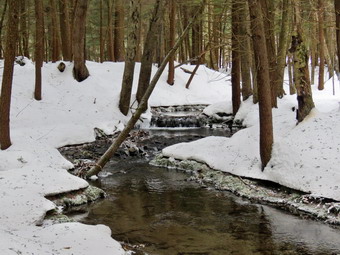 At the junction with the Big Rock Trail, we turned left to stay on the Quick Lake Trail. Immediately I noticed that there were snowmobile tracks coming from the Big Rock Trail and then heading out the Quick Lake Trail toward Iron Wheel Junction. These trails are off-limits to snowmobiles but some inconsiderate riders simply don't pay attention to the signs or the rules. Snowmobiles passing over the wooden walkways will quickly destroy the already fragile structures. It is sad that some people only think of themselves and give others in a group a bad name. I made a note to contact the Region 3 DEC office in New Paltz as well as the local forest rangers. I would love to see some tickets issued! We followed the trail which was packed from the snowmobiles. We walked through the "spruce tunnel" and came to the small stream through the woods. It was flowing freely with a greater volume than I had seen in a long time. The snowmobiles had made a mess of the crossing. I stopped to take a few pictures before walking upstream to cross in a shallower and more narrow area. Sheila came with me and hopped across the stream without getting wet. I had been worried about her feet getting too cold but she seemed unfazed. After crossing we continued on the Quick Lake Trail to Iron Wheel Junction. This part of the trail showed signs that the heavy rains that came before the snow had washed over the trail and some areas were still wet. At the junction, we turned left to stay on the Quick Lake Trail. This is a legal snowmobile trail and was packed making the walking easy. When we came to the junction where the snowmobile trail turns left, there continued to be some snowmobile tracks on the Quick Lake Trail and the packed snow made walking a breeze. It is 1.6 miles from Iron Wheel Junction to Junkyard Junction with an elevation gain of almost 500 feet. This walk often seems long, but I must have been lost in my thoughts as it seemed to go very quickly despite the increased difficulty of walking on the snow. The trail was eroded in many places showing the power of the water that had run down the trail. When we came to Junkyard Junction, we turned right onto the Flynn Trail at the junction and started toward Hodge Pond. I did not know whether or not the snowmobiles had been on the trails. The Flynn Trail was pristine with no tracks of any kind! This made walking much harder and I now regretted that I was not wearing snowshoes! The Flynn Trail from Junkyard Junction to Hodge Pond is .85 miles and drops 165 feet to the shores of the pond. The first part of the trail is flat but the snow varied from almost none to as much as 10 inches. I tried to walk where there was the lest amount of snow bit in places that was not easy. After passing through the gate that marks the boundary with the OSI property, we walked down the hill toward the pond and turned right to stay on the Flynn Trail. There was still about the same amount of snow but it seemed to have a harder crust that could support me at times. This part of the trail is, again, flat and is situated along a woods road that OSI cleared of all vegetation. We soon left the trees and entered a field. There was some blue sky and sun and it made me feel warmer except for the breeze blowing in the open area. We continued on the trail to the clearing at the south end of Hodge Pond. The snow was almost gone here but there was a nice icy covering. We walked over to the shores of the pond where I put down my pack and got out the camera. The skies had grown darker but I took some pictures of the pond and the clearing. After a short time, I ate a bar, took some water and packed up to continue on the Flynn Trail.
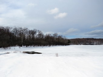 We walked back to the Flynn Trail to the point where it re-entered the woods and began the walk up the hill. The snow had drifted at the beginning of the trail to about a foot and it continued to be deep most of the way up the hill. Walking through the snow and sinking in going uphill was taking a toll on me but not on Sheila. Near the top of the hill Sheila began to alert and I eventually saw a man and his dog coming toward us on the Flynn Trail. He said his dog was friendly and I replied that mine was "sometimes friendly." I put Sheila on her leash and continued to walk up the hill. I stopped to talk to the other hiker was smart enough to wear snowshoes. After we had talked for a few minutes, we headed our separate ways. He was pretty sure he would continue on to compete the loop around both ponds in the opposite direction I had chosen. Unfortunately, the Flynn Trail here had snowmobile tracks but it did make the walking easier. The Flynn Trail is relatively flat to the junction with the Big Rock Trail at 4.7 miles into the hike. The snowmobiles had simply ignored the sign indicating the trail was not open for them and the large octagonal red sign that said "STOP". We passed through the gate marking the border with the OSI property and soon after arrived at the junction with the Big Rock Trail. The Big Rock Trail and the trail over the hill to Mongaup Pond both had snowmobile tracks. The Flynn Trail continued straight ahead and there were no snowmobile tracks. We continued on the Flynn Trail as I tried to follow the tracks left by the snowshoer we had met. This made the waking easier but not easy as I was still sinking in from one to four inches. At least the Flynn Trail either descends or is flat all the way back to the car. The walk on this day seemed long and I kept anticipating the end. As we walked along, Sheila alerted, and I saw a couple coming toward us. The man had no snowshoes but did have spikes. This made me feel a little better. The woman did have snowshoes but looked tired as she came toward us. We stopped to talk as Sheila behaved herself. The man said he had left his snowshoes behind and I indicated mine were also in the car. They asked about the distances to Frick Pond by way of the Big Rock Trail and I gave them that information. We parted as Sheila and I headed downhill. Somewhere along the way, I looked to the side of the trail and saw a pair of snowshoes! The male hiker had taken them off and left them on the trail. I was surprised because if I had been wearing snowshoes coming up the trail I would have congratulated myself on a good decision and continued wearing the. I though about putting them in and wearing them back to the parking area since I thought that would work for both of us. In the end I left them where they were assuming he would walk back uphill to retrieve them. We continued on down the trail and passed through the "tunnel" that Cindy and I had cut in the large spruce tree. Just before the gate we turned left to follow the Flynn Trail and to avoid the private property around the cabin. I heard barking and once again the same dog ran toward us. I was tired and very annoyed. I shouted at him to go home as the owner tried to call him. Once again the owner paid no attention. I put this all on the owner since he obviously had not learned anything from the encounter several hours before. When he finally took hold of the dog and mumbled "Sorry", I almost said "But not very sorry!" I kept my thoughts to myself and continued on the trail with Sheila on her leash. When we arrived back at the parking lot, there were three other cars present in the small lot and one in the larger lot. We were back at the car by 3:30 PM having covered 6.4 miles in 3.5 hours with an elevation gain of 910 feet. The temperature had risen to 23 degrees.
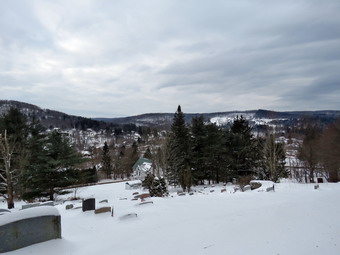
![]()
![]()
![]()
![]()
![]() On Wednesday, January 23rd I wanted to get out for a hike after several days of snow, ice and rain and bitter cold. My plans were interrupted by an early morning ambulance call for in Roscoe. I returned from the call and ate breakfast at Caf� 43. When I got home, I suggested to Sheila that we go "out" for a "hike" and she instantly became crazed and would not leave my sight while whining all the time. I invited Cindy but she was starting to come down with a cold and preferred to stay inside. I decided that I would go across the street to hike on Round Top since rain and ice were in the forecast for late morning. In addition, I was confident that I would have to break the trail through the crusted snow and knew it would be tiring. The temperature was in the low 20's as I got ready to hike around 9:30 AM. The skies were completely overcast. I put on a long-sleeved base layer and wore my Mammut pullover which is heavier than most others I own. I put on a pair of tights underneath my Columbia Omniheat hiking pants. These have a reflective lining and are heavier than my "go to" Railriders pants. The pants have Velcro closures at the ankles which means gaiters are not usually needed until the snow gets deeper. I donned my Mammut hoody which has enough zippers to dump heat if needed. I put on a heavier hat and gloves. I wore my Salomon B52 winter boots which are all leather and seem to be waterproof with sufficient insulation. I decided to put on a pair of OR Crocodile gaiters. I grabbed a pair of Leki poles with external locks that I have been using lately. I put on my Tubbs Alp Flex VTR snowshoes with the Boa binding. This binding uses a thin steel cable system and a ratchet which tightens it to give a custom fit and a secure binding. These shoes also have a televator to elevate the hiker's heel on ascents. This is a feature that you didn't know you needed until you try it and then it is hard to live without it! I shouldered my pack since I wanted to take some pictures. At 10:05 AM we walked out the door where I put on my snowshoes. I grabbed Sheila's leash from the car and we walked up the driveway. She pulled me up the driveway knowing exactly where we were going. There was only a light covering of snow but there were patches of ice which made the going slippery. The snowshoes helped a lot except when we crossed the road. I decided we would start with a figure 8's just for the exercise and then I would decide if I wanted to do anything more. I aimed to hike for about an hour. We crossed the street with Sheila on her leash and walked to the back of the church. We began the ascent of the steepest hill behind the church. The hill is short but gets the circulation pumping and is the steepest and longest climb on the "trail." Sheila helped me along by pulling me up the hill. She actually pulls harder when there is snow which has to be her husky blood. When we got to the top of the hill, I paused for a moment and put down my pack. I got out my camera and took pictures of the snow covered town and the hills beyond. We started on the trail by turning left at the trailhead. I let Sheila off her leash, and she began to explore the trail with her nose. As we followed the trail, I noticed that there was only between 4 and 6 inches of snow topped by a hard crust. The rain late on Sunday had reduced the amount of snow but the bitter cold on Monday had frozen the top layer.
On Wednesday, January 23rd I wanted to get out for a hike after several days of snow, ice and rain and bitter cold. My plans were interrupted by an early morning ambulance call for in Roscoe. I returned from the call and ate breakfast at Caf� 43. When I got home, I suggested to Sheila that we go "out" for a "hike" and she instantly became crazed and would not leave my sight while whining all the time. I invited Cindy but she was starting to come down with a cold and preferred to stay inside. I decided that I would go across the street to hike on Round Top since rain and ice were in the forecast for late morning. In addition, I was confident that I would have to break the trail through the crusted snow and knew it would be tiring. The temperature was in the low 20's as I got ready to hike around 9:30 AM. The skies were completely overcast. I put on a long-sleeved base layer and wore my Mammut pullover which is heavier than most others I own. I put on a pair of tights underneath my Columbia Omniheat hiking pants. These have a reflective lining and are heavier than my "go to" Railriders pants. The pants have Velcro closures at the ankles which means gaiters are not usually needed until the snow gets deeper. I donned my Mammut hoody which has enough zippers to dump heat if needed. I put on a heavier hat and gloves. I wore my Salomon B52 winter boots which are all leather and seem to be waterproof with sufficient insulation. I decided to put on a pair of OR Crocodile gaiters. I grabbed a pair of Leki poles with external locks that I have been using lately. I put on my Tubbs Alp Flex VTR snowshoes with the Boa binding. This binding uses a thin steel cable system and a ratchet which tightens it to give a custom fit and a secure binding. These shoes also have a televator to elevate the hiker's heel on ascents. This is a feature that you didn't know you needed until you try it and then it is hard to live without it! I shouldered my pack since I wanted to take some pictures. At 10:05 AM we walked out the door where I put on my snowshoes. I grabbed Sheila's leash from the car and we walked up the driveway. She pulled me up the driveway knowing exactly where we were going. There was only a light covering of snow but there were patches of ice which made the going slippery. The snowshoes helped a lot except when we crossed the road. I decided we would start with a figure 8's just for the exercise and then I would decide if I wanted to do anything more. I aimed to hike for about an hour. We crossed the street with Sheila on her leash and walked to the back of the church. We began the ascent of the steepest hill behind the church. The hill is short but gets the circulation pumping and is the steepest and longest climb on the "trail." Sheila helped me along by pulling me up the hill. She actually pulls harder when there is snow which has to be her husky blood. When we got to the top of the hill, I paused for a moment and put down my pack. I got out my camera and took pictures of the snow covered town and the hills beyond. We started on the trail by turning left at the trailhead. I let Sheila off her leash, and she began to explore the trail with her nose. As we followed the trail, I noticed that there was only between 4 and 6 inches of snow topped by a hard crust. The rain late on Sunday had reduced the amount of snow but the bitter cold on Monday had frozen the top layer.
At the first trail junction, I followed Sheila as she continued straight ahead up the hill toward the lookout. It was harder breaking trail through the crusty snow than I remembered! We followed the yellow blazes up to the spur trail to the viewpoint and followed it out to the rock outcropping. There is one spot where there is a gap that has to be crossed and it was a little tricky on snowshoes. At the viewpoint, I took off my pack and took out the camera. The skies were still overcast but I took pictures of town especially the school. I also snapped some shots of the hills around town and a few of Sheila posing on the upper part of the lookout. I walks up the steep trail to the upper lookout and picked up the yellow blazes again. We followed the trail uphill a little toward the next trail junction. At the junction, we turned right to follow the yellow trail along the base of Round Top. The snow was fresh and no one else had been on the trail since the snow. At the next trail junction, we turned left on the blue trail and walked up toad the summit of Round Top. The snowshoes gripped well but I still slipped backwards several times. Soon we were walking across the summit plateau. We started down the steeper side and I was able to get a glide on the snowshoes down the hill. Once we got to the yellow trail, we turned left and walked to the trail junction again. This time we turned right and followed the trail down to the woods road. We walked downhill on the woods road to the first trail junction finding one tree across the trail. By this time I was feeling better especially going down the hill. When we arrived at the first trail junction, I decided we would do a small loop so we turned around and started back up the more gentle slope we had just descended. We followed the yellow blazes up the woods road to the next trail junction where we turned left to walk along the base of Round Top. At the next junction with the blue trail, we turned left and began to walk downhill toward the lookout. I noticed by coat was wet and when we stopped I could see and hear rain beginning to fall. We followed the yellow trail down the hill to the lookout as the rain continued to fall mixed with a few snowflakes and some sleet. At the lookout we turned left and followed the yellow blazes on the trail back to the first rail junction. We continued straight ahead on the yellow trail to the trailhead. Sheila was well-behaved and stayed with me most of the time. We walked down the cemetery hill as the rain continued to fall. At the base of the hill, I put Sheila on her leash and we walked across the field to our driveway. It was 11:35 AM and we had hiked 1.8 miles in an hour and 25 minutes.
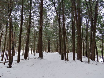
![]()
![]()
![]()
![]()
![]() On Saturday, January 19th, I had planned to hike Cabot Mountain from Beech Hill Road before the snow began. I maintain the trail from Beech Hill Road to Alder Lake for the Finger Lakes Trail Conference and I thought it would be nice to see the condition of the trail after some of the high winds we experienced lately. Once again we responded to a late night and early morning ambulance call and I did not get to sleep until 2:00 AM. I slept in to almost 10:00 AM and decided to alter my plans and go to Frick Pond instead. I was feeling a little better after weeks of coughing and knew getting out would make me feel better mentally. My plan was to ascend the Flynn Trail and then get the long descent on the Big Rock Trail with, perhaps, a visit to Hodge Pond. I made a run to the landfill and ate breakfast before getting ready to go. The temperature was 27 degrees when I was about to get dressed but I knew that hiking in the snow always makes me very warm. I knew there would not be enough snow to snowshoe but the forecast was for a foot or more of snow and mixed precipitation overnight into Sunday. I put on a long-sleeved baselayer underneath my Mammut pullover which is heavier than most others I own. I decided not to put on a pair of tights beneath my Columbia Omniheat hiking pants which have a reflective lining. The pants have Velcro closures at the ankles which means gaiters are not usually needed until the snow gets deeper. In this case, I anticipated deeper snow, so I did wear a pair of OR Crocodile gaiters. I donned my Mammut hoody which has enough zippers to dump heat if needed. I put on a heavier hat and gloves. I wore my Salomon B52 winter boots as they are insulated and almost completely waterproof. I grabbed a pair of Leki poles with external locks that I have been using lately and made sure I had my microspikes in my pack. Sheila was more crazed than usual as I got my gear ready. We left Livingston Manor just after 11:30 AM to head out the DeBruce Road. It had snowed a little in the morning but DeBruce Road was clear. At six miles I turned left onto Mongaup Pond Road which had some snow on it but had been plowed and sanded. Where the road split I stayed left on Beech Mountain Road and parked in the small lot which was partly plowed. There were two vehicles in the larger lot and as I got ready another pulled in. I set my electronics noting the temperature was 25 degrees. There was a slight breeze and the skies were completely overcast as we crossed the road at 11:50 AM to start up the Flynn Trail. I was concerned that the snow might start before we were done and had several options to control the length of the hike. I found that I was warm as long as I was moving but felt cool as son as I stopped. I hoped that I had not dressed too lightly! The first part of the Flynn Trail through the woods is narrow and we passed under one low-hanging blowdown. I cleared some branches as we walked thinking it would make snowshoeing easier. Once we made the right turn into the woods road the going was easier. There were tracks from two people headed up the trail and one appareled to be a woman from the shoe size. Other tracks indicated they had a good-sized dog with them. Their were all kinds of tracks in the fresh snow made my various animals including Sheila as she bounded ahead joyfully. Walking on the few inches of snow was a little tiring but the traction was good. Not too far up the trail I noticed a couple coming toward us with a dog. I put Sheila on her leash and the other hikers did the same for their dog. When we met, we stopped to talk for minute. Their dog had the black and brown marking of a Rottweiler or Doberman and was playfully crouched in the snow. Sheila seemed to want to take him up on his offer. The couple said they had only hiked to the top of the hill and just wanted to get a short walk in before the storm. I suggested that they visit Frick Pond before leaving and they seemed interested. I described the Frick Pond Loop before we went in our Seagate directions. I stopped to open some zippers to dump some heat and while stopped took a few pictures of the snowy trail. As we gained some elevation, the snow got deeper until there was almost 4 inches.
On Saturday, January 19th, I had planned to hike Cabot Mountain from Beech Hill Road before the snow began. I maintain the trail from Beech Hill Road to Alder Lake for the Finger Lakes Trail Conference and I thought it would be nice to see the condition of the trail after some of the high winds we experienced lately. Once again we responded to a late night and early morning ambulance call and I did not get to sleep until 2:00 AM. I slept in to almost 10:00 AM and decided to alter my plans and go to Frick Pond instead. I was feeling a little better after weeks of coughing and knew getting out would make me feel better mentally. My plan was to ascend the Flynn Trail and then get the long descent on the Big Rock Trail with, perhaps, a visit to Hodge Pond. I made a run to the landfill and ate breakfast before getting ready to go. The temperature was 27 degrees when I was about to get dressed but I knew that hiking in the snow always makes me very warm. I knew there would not be enough snow to snowshoe but the forecast was for a foot or more of snow and mixed precipitation overnight into Sunday. I put on a long-sleeved baselayer underneath my Mammut pullover which is heavier than most others I own. I decided not to put on a pair of tights beneath my Columbia Omniheat hiking pants which have a reflective lining. The pants have Velcro closures at the ankles which means gaiters are not usually needed until the snow gets deeper. In this case, I anticipated deeper snow, so I did wear a pair of OR Crocodile gaiters. I donned my Mammut hoody which has enough zippers to dump heat if needed. I put on a heavier hat and gloves. I wore my Salomon B52 winter boots as they are insulated and almost completely waterproof. I grabbed a pair of Leki poles with external locks that I have been using lately and made sure I had my microspikes in my pack. Sheila was more crazed than usual as I got my gear ready. We left Livingston Manor just after 11:30 AM to head out the DeBruce Road. It had snowed a little in the morning but DeBruce Road was clear. At six miles I turned left onto Mongaup Pond Road which had some snow on it but had been plowed and sanded. Where the road split I stayed left on Beech Mountain Road and parked in the small lot which was partly plowed. There were two vehicles in the larger lot and as I got ready another pulled in. I set my electronics noting the temperature was 25 degrees. There was a slight breeze and the skies were completely overcast as we crossed the road at 11:50 AM to start up the Flynn Trail. I was concerned that the snow might start before we were done and had several options to control the length of the hike. I found that I was warm as long as I was moving but felt cool as son as I stopped. I hoped that I had not dressed too lightly! The first part of the Flynn Trail through the woods is narrow and we passed under one low-hanging blowdown. I cleared some branches as we walked thinking it would make snowshoeing easier. Once we made the right turn into the woods road the going was easier. There were tracks from two people headed up the trail and one appareled to be a woman from the shoe size. Other tracks indicated they had a good-sized dog with them. Their were all kinds of tracks in the fresh snow made my various animals including Sheila as she bounded ahead joyfully. Walking on the few inches of snow was a little tiring but the traction was good. Not too far up the trail I noticed a couple coming toward us with a dog. I put Sheila on her leash and the other hikers did the same for their dog. When we met, we stopped to talk for minute. Their dog had the black and brown marking of a Rottweiler or Doberman and was playfully crouched in the snow. Sheila seemed to want to take him up on his offer. The couple said they had only hiked to the top of the hill and just wanted to get a short walk in before the storm. I suggested that they visit Frick Pond before leaving and they seemed interested. I described the Frick Pond Loop before we went in our Seagate directions. I stopped to open some zippers to dump some heat and while stopped took a few pictures of the snowy trail. As we gained some elevation, the snow got deeper until there was almost 4 inches.
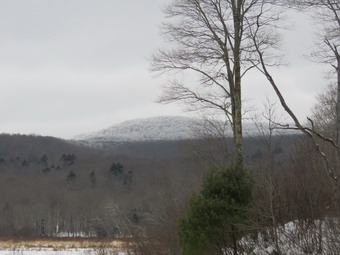 We continued up the Flynn Trail toward the junction with the Big Rock Trail. I was feeling pretty good at first but as we approached the trail junction I could feel that walking on the snow was making my lower legs and feet tired. At 12:50 PM we were at the trail junction with the Big Rock Trail and it had begun to snow. In a few minutes it had changed from a few flakes to light snow so I decided to head down the Big Rock Trail. The snow on the Big Rock Trail showed signs that a snowmobile had been over it and I hoped the club had been working to remove some of the blowdowns. We turned lefty to start the long descent and my legs immediately felt better as gravity helped. I was sure I didn't have many more "ups" left in me but the descent felt great. The trip down the Big Rock Trail went quickly although it seemed a little longer than usual. In several places, large trees had been cut and moved by the snowmobile club. There are three places where the trail drops quickly and then levels off. The last place brought us right to Times Square where the Logger's Loop and Big Rock Trail cross. Sheila was having a great time and did not seem to be bothered in any way by the snow or temperature. She kept going off the trail to follow animals tracks but returned quickly when I called. We continued straight ahead at Times Square to go around the back of Frick Pond. I did stop for a minute to take a few shots before continuing the hike. I also got out a bar I had kept in an inside pocket in my hoody but it was still pretty stiff. The trail around the pond was completely broken by more tracks than I could count. The hike around the pond is a favorite and is one promoted by Lisa at Morgan Outdoors in Livingston Manor. I stopped in the evergreen forest to take some pictures before continuing to walk toward the bridges and wooden walkways. The skies were even more overcast snow, a wind was blowing and some snow was still falling. The wooden walkways were covered in snow that had been beaten down by the traffic so I did not stop to take pictures. We continued to walk until we came to the junction with the Quick Lake Trail. Here we turned left and headed for the bridge across the outlet of Frick Pond. We stopped briefly at the bridge and I took a few pictures of the pond and Flynn's The pond still had some open water. Flynn's Point on Beech Mountain had a very clear line of debarkation above which there was ice on the trees. I was a little disappointed since I would have modified my hike to include that area. We walked up the hill from the pond to Gravestone Junction to head back to the parking area and I felt even this short uphill in my legs. The trail was well covered in snow with only a few spots where there was some water. At the trail register, we turned right to stay on the Quick Lake Trail back t the parking areas. When we arrived at the parking lots, all the cars were gone! We were back at 1:50 PM having covered 4.0 miles in 2 hours and 5 minutes with an elevation gain of 680 feet.
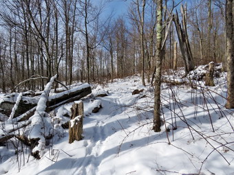
![]()
![]()
![]()
![]()
![]() On Thursday, January 17th I wanted to get in a longer hike even though I was till continuing to fight cold symptoms and a cough that had hung on for 4 weeks. I got up at 5:15 AM and went to my church to participate in a men's bible study group. When I returned to Livingston Manor, I ate breakfast at Caf� 43 and then headed home. I was still tired from lack of sleep due to the cold so I got some rest waking up at about 10:00 AM. At this point the temperature was still only 2 degrees but it was beginning to be almost sunny out and I knew the walk would make me feel better. I began to get ready to go for a hike from Big Pond to Alder Lake and back. I maintain this section of trail for the Finger Lakes Trail Conference and wanted to see what shape it was in after the recent heavy rain and high winds. While we were getting ready, Sheila was always nearby making it very clear that she wanted to go. I put on a long-sleeved baselayer underneath my Mammut pullover which is heavier than most others I own. I put on a pair of tights beneath my Columbia Omniheat hiking pants which have a reflective lining. The pants have Velcro closures at the ankles which means gaiters are not usually needed until the snow gets deeper. I donned my Mammut hoody which has enough zippers to dump heat if needed. I put on a heavier hat and gloves. I wore my Vasque Talus hiking boots instead of the Salomon B-52 winter boots. I wear regular hiking boots whenever I can as I feel they are a better fit and offer more support. I grabbed a pair of Leki poles with external locks that I have been using lately and made sure I had my microspikes in my pack. We left Livingston Manor at about 10:30 AM as I drove out Old Rt 17 to the Beaverkill Road where I turned right. I drove through Lew Beach toward Turnwood. At the intersection with the Barkaboom Road I stayed to the left on Barkaboom Road until I came to the access road to the upper parking area at Big Pond. I was pleased that the road had only a light covering of snow And I was able to drive into the empty parking area. As I was getting ready just before 11:00 AM the temperature was 18 degrees with a slight breeze. I was surprised to see several inches of snow on the rail and regretted my choice of boots since the Vasque Talus are not insulated. I also had not thought to put on a pair of gaiters! Sheila loves the snow and was running around until we started out on the trail toward Alder Creek Road. The initial part of the trail is pretty flat for a long time and passes several campsite areas before descending a little. After that the trail begins to ascend on an old woods road. At .5 miles the trail turns off the woods road but continues to ascend until about 1 mile gaining 450 feet at a 10% grade. This isn't very steep but I could feel that it was harder than I expected which is a direct result of my limited hiking and the sickness I have experienced. I removed a few branches along the way and found a couple of blowdowns that could be cleared with hand tools but would be more easily handled with a chainsaw. My feet were a little cold but at least the snow was not kicking up into my boots. After about the 1 mile mark the trail flattens and then begins to descend into a little valley cut my a seasonal stream. It was very hard to follow the rail as it is poorly marked in this area and several blowdowns blocked the trail. The DEC decided several years ago that volunteers could not be trusted to mark the trails with blazes and handed that job over to foresters. Since that time, the blazing of the secondary trails has been poor and few new blazes have been placed. There were also places along the trail that had some briars that I knew would have to be cleared in the spring.
On Thursday, January 17th I wanted to get in a longer hike even though I was till continuing to fight cold symptoms and a cough that had hung on for 4 weeks. I got up at 5:15 AM and went to my church to participate in a men's bible study group. When I returned to Livingston Manor, I ate breakfast at Caf� 43 and then headed home. I was still tired from lack of sleep due to the cold so I got some rest waking up at about 10:00 AM. At this point the temperature was still only 2 degrees but it was beginning to be almost sunny out and I knew the walk would make me feel better. I began to get ready to go for a hike from Big Pond to Alder Lake and back. I maintain this section of trail for the Finger Lakes Trail Conference and wanted to see what shape it was in after the recent heavy rain and high winds. While we were getting ready, Sheila was always nearby making it very clear that she wanted to go. I put on a long-sleeved baselayer underneath my Mammut pullover which is heavier than most others I own. I put on a pair of tights beneath my Columbia Omniheat hiking pants which have a reflective lining. The pants have Velcro closures at the ankles which means gaiters are not usually needed until the snow gets deeper. I donned my Mammut hoody which has enough zippers to dump heat if needed. I put on a heavier hat and gloves. I wore my Vasque Talus hiking boots instead of the Salomon B-52 winter boots. I wear regular hiking boots whenever I can as I feel they are a better fit and offer more support. I grabbed a pair of Leki poles with external locks that I have been using lately and made sure I had my microspikes in my pack. We left Livingston Manor at about 10:30 AM as I drove out Old Rt 17 to the Beaverkill Road where I turned right. I drove through Lew Beach toward Turnwood. At the intersection with the Barkaboom Road I stayed to the left on Barkaboom Road until I came to the access road to the upper parking area at Big Pond. I was pleased that the road had only a light covering of snow And I was able to drive into the empty parking area. As I was getting ready just before 11:00 AM the temperature was 18 degrees with a slight breeze. I was surprised to see several inches of snow on the rail and regretted my choice of boots since the Vasque Talus are not insulated. I also had not thought to put on a pair of gaiters! Sheila loves the snow and was running around until we started out on the trail toward Alder Creek Road. The initial part of the trail is pretty flat for a long time and passes several campsite areas before descending a little. After that the trail begins to ascend on an old woods road. At .5 miles the trail turns off the woods road but continues to ascend until about 1 mile gaining 450 feet at a 10% grade. This isn't very steep but I could feel that it was harder than I expected which is a direct result of my limited hiking and the sickness I have experienced. I removed a few branches along the way and found a couple of blowdowns that could be cleared with hand tools but would be more easily handled with a chainsaw. My feet were a little cold but at least the snow was not kicking up into my boots. After about the 1 mile mark the trail flattens and then begins to descend into a little valley cut my a seasonal stream. It was very hard to follow the rail as it is poorly marked in this area and several blowdowns blocked the trail. The DEC decided several years ago that volunteers could not be trusted to mark the trails with blazes and handed that job over to foresters. Since that time, the blazing of the secondary trails has been poor and few new blazes have been placed. There were also places along the trail that had some briars that I knew would have to be cleared in the spring.
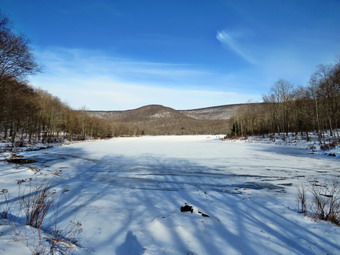 I stopped to take a few pictures of the snowy landscape which was quite different than what we had in town. On the descent of the hill we ran into several areas that are usually wet and muddy but most of them were frozen enough to cross without a problem. We passed an old foundation and several extensive stone walls. I knew we were headed down to a small stream. When we got to the stream, I was surprised to find that there was a good flow of water. I stopped to take a few shots of the stream and the valley downstream from the area. My feet were still cold but I decided to walk at least as far as the beaver meadow. We crossed the stream and turn left to begin the walk uphill toward the beaver meadow. We ran into a blowdown blocking the trail but I was able to squeeze through it. The uphill walk was tiring but we were soon at the beaver meadow after hiking about 2 miles. We stopped at the beaver meadow where I took a few more shots. At 2.2 miles we turned east and completed the climb to the top of the hill. Once again we began to descend a hill as we headed for Alder Creek Road and I thought about the climb back up the hill! Eventually the trail flattened out and we came to Alder Creek. We crossed it easily and walked up to the road where we turned around at 12:45 PM to retrace our steps to the car. We now had to walk up all the hills we walked down on the way out! We set a pretty fast pace and did not stop for pictures. At 3.6 miles we descended a hill and made a left turn to head south passed the beaver meadow. After crossing the stream, we began another long hike uphill. Along the way, we stopped so that I could take some pictures of the old foundation and stone walls. I did notice that my feet were not as cold. The hike from the stream to the top of the hill was ,8 miles and gained over 300 feet but seemed easier than on the way out. At 4.8 miles we hit the top of the last hill and I was glad that the rest of the trip was downhill. We were back at the car at 2:30 PM after hiking 6.0 miles in 3 hours ad 30 minutes. The total elevation gain was 1425 feet. The sun was out and beginning to soften the snow but the air temperature was only 25 degrees. As I left the parking area, decided to go just up the road to Big Pond. I parked and walked down to the shore to take some pictures. The pond was covered in ice but there were some open spots near shore. There were several groups of people ice fishing. I walked back to the car and headed back down Barkaboom Road. I decided to go to Alder Lake to take some pictures. I knew that the gate would be closed but that it is only a short walk to the lake. I turned left on the Beaverkill Road and drove to Alder Creek Road where I turned left. I drove to the end of Alder creek Road and turned left and found...the gate to the access road to Alder Lake open! I drove in and parked near the other car in the lot. I let Sheila out of the car and grabbed the camera. I took some shots of the stonework that was once the Coykendall mansion and then walked down the "lawn" to a point near the shore. There was 5 or 6 inches of snow in places. The skies were clear and blue but there were very few clouds. I took several pictures of the lake and Cradle Rock Ridge and the turned around to take more pictures of the stonework. Sheila and I returned to the car and I drove out the access road bad home.
![]()
![]()
![]()
![]() On Wednesday, January 16th I had planned to get in a longer hike perhaps near Alder Lake as I was feeling better. Once again there an ambulance call in the middle of the night. Even though it was cancelled, it was hard for me to get back to sleep so I slept until almost 9:0 AM. I finally decided at 10:00 AM that I would take Sheila and go across the street to Round Top since I had to leave early for a track meet at SCCC. I asked Cindy if she wanted to go and she agreed. The temperature outside registered as 29 degrees with a little sun. I started to get ready with Sheila encouraging me at very turn. I put on a base layer under my Mammut pullover which is heavier than most others I own. I put on a pair of Columbia Omniheat hiking pants which have a reflective lining. The pants have Velcro closures at the ankles which means gaiters are not usually needed until the snow gets deeper. I donned my Mammut hoody which has enough zippers to dump heat if needed. I put on a heavier hat and gloves. I wore my Vasque Talus hiking boots instead of the Salomon B-52 winter boots. I wear regular hiking boots whenever I can as I feel they are a better fit and offer more support. I grabbed a pair of Leki poles with external locks that I have been using lately but chose to leave my microspikes at home. At 10:30 AM we walked out the door. I got Sheila's leash from my car and put her on it so that she could pull me up the slippery driveway. I decided we would try to do at least two figure 8's which might be enough given the situation. I aimed to hike for about an hour. Sheila was happy to get out as we headed down the driveway and across the street. We crossed the street and walked across the field to the back of the church. We began the ascent of the steepest hill behind the church which was completely bare of snow and ice. The hill is short but gets the circulation pumping and is the steepest and longest climb on the "trail." Sheila helped me along by pulling me up the hill. When we got to the top of the hill, we started on the trail by turning left at the trailhead. I let Sheila off her leash, and she began to explore the trail with her nose. As we followed the trail, I noticed there was a covering of snow and that there were footprints in it. I am always happy to see that someone else uses the trails. At the first trail junction, we followed Sheila as she turned right on the woods road which is the shallower approach to the trail system. We continued to follow the yellow trail to the first junction where we turned left and followed it to the next trail junction. There was one blowdown across the trail which would require an axe to clear.
On Wednesday, January 16th I had planned to get in a longer hike perhaps near Alder Lake as I was feeling better. Once again there an ambulance call in the middle of the night. Even though it was cancelled, it was hard for me to get back to sleep so I slept until almost 9:0 AM. I finally decided at 10:00 AM that I would take Sheila and go across the street to Round Top since I had to leave early for a track meet at SCCC. I asked Cindy if she wanted to go and she agreed. The temperature outside registered as 29 degrees with a little sun. I started to get ready with Sheila encouraging me at very turn. I put on a base layer under my Mammut pullover which is heavier than most others I own. I put on a pair of Columbia Omniheat hiking pants which have a reflective lining. The pants have Velcro closures at the ankles which means gaiters are not usually needed until the snow gets deeper. I donned my Mammut hoody which has enough zippers to dump heat if needed. I put on a heavier hat and gloves. I wore my Vasque Talus hiking boots instead of the Salomon B-52 winter boots. I wear regular hiking boots whenever I can as I feel they are a better fit and offer more support. I grabbed a pair of Leki poles with external locks that I have been using lately but chose to leave my microspikes at home. At 10:30 AM we walked out the door. I got Sheila's leash from my car and put her on it so that she could pull me up the slippery driveway. I decided we would try to do at least two figure 8's which might be enough given the situation. I aimed to hike for about an hour. Sheila was happy to get out as we headed down the driveway and across the street. We crossed the street and walked across the field to the back of the church. We began the ascent of the steepest hill behind the church which was completely bare of snow and ice. The hill is short but gets the circulation pumping and is the steepest and longest climb on the "trail." Sheila helped me along by pulling me up the hill. When we got to the top of the hill, we started on the trail by turning left at the trailhead. I let Sheila off her leash, and she began to explore the trail with her nose. As we followed the trail, I noticed there was a covering of snow and that there were footprints in it. I am always happy to see that someone else uses the trails. At the first trail junction, we followed Sheila as she turned right on the woods road which is the shallower approach to the trail system. We continued to follow the yellow trail to the first junction where we turned left and followed it to the next trail junction. There was one blowdown across the trail which would require an axe to clear.
At the second junction with the blue trail, we turned right and started up the steep blue trail that leads over the summit of Round Top. This section of the trail faces west and north so there was more snow And some was packed and slippery. I was able to get a grip with little or no problem but Cindy struggled a little. We walked across the flat summit of Round Top and started down the other side. Descending on the snow and frozen ground proved to be more of a challenge than I had expected and Cindy moved gingerly down the slope. Soon we were back at the yellow trail. We turned right and walked the yellow trail to the next trail junction. Here we turned left and followed the yellow trail downhill to the lookout. There wasn't much to see at the lookout so we continued on the trail. We followed the yellow trail as it turned left and descended the hill to the first trail junction. The walk had gone quickly, so we turned around and started back up the hill back to the lookout. Cindy made it clear she did not want to go back up to the summit so I decided we would do a short loop. Sometimes Sheila resists another loop but this time she was in the lead. We followed the yellow trail uphill toward the lookout and turned right to continue up to the next trail junction with the blue trail. Here we turned right to stay on the yellow trail. At the next junction we also turned right and walked down the trail to the woods road that leads back to the first trail junction. I wanted to get in some more hiking so I turned around and started back up the woods road and was a little surprised when Cindy followed me. We followed the lower yellow trail making another circuit up and down and back to the first trail junction. Cindy was done and headed home but Sheila and I turned around and walked back up toward the lookout. I intended to do another figure 8. At the lookout we followed the yellow trail to the right and back to the first junction with the blue trail. We turned right and followed the yellow trail along the base of Round Top to the next junction. We turned left and walked up the slippery slope to the summit of Round Top. We walked across the top and started down the other side. It was a little tricky on the descent but we soon returned to the lower trail. We turned left and walked back to the trail junction/ We trued right and followed the yellow trail down to the woods road and out to the very first trail junction. That was enough for me. We turned left and walked out to the trailhead. Sheila was well-behaved and stayed with me most of the time. I put her on her leash and we walked down the cemetery hill. We walked across the field to our driveway. It was around noon and we had hiked over 2 miles in an hour and a half.
![]()
![]()
![]()
![]() On Saturday, January 12th I had planned to get in a longer hike perhaps near Alder Lake as I was feeling better and the hike the day before had felt good. Once again there an ambulance call in the middle of the night. I did not get back to bed until 3:00 AM and slept until almost 8:30 AM. I caught up one some work and emails that had accumulated while I was at a church retreat. I finally decided at 2:00 PM that I would take Sheila and go across the street to Round Top. The temperature outside registered as 24 degrees with a little sun. I didn't even feel like going across the street to hike but Sheila's enthusiasm prevailed. I started to get ready with Sheila encouraging me at very turn. I did not put on a base layer but wore my Mammut pullover which is heavier than most others I own. I put on a pair of Columbia Omniheat hiking pants which have a reflective lining and are heavier than my "go to" Railriders pants. The pants have Velcro closures at the ankles which means gaiters are not usually needed until the snow gets deeper. I donned my Mammut hoody which has enough zippers to dump heat if needed. I put on a heavier hat and light gloves. I wore my Vasque Talus hiking boots instead of the Salomon B-52 winter boots. I wear regular hiking boots whenever I can as I feel they are a better fit and offer more support. I grabbed a pair of Leki poles with external locks that I have been using lately but chose to leave my microspikes at home. At 2:30 PM Sheila and I walked out the door. I got Sheila's leash from my car and put her on it so that she could pull me up the slippery driveway. I decided we would try to do at least two figure 8's which might be enough given the situation. I aimed to hike for about an hour. Sheila was happy to get out as we headed down the driveway and across the street. We crossed the street and walked across the field to the back of the church. We began the ascent of the steepest hill behind the church which only had a very light shrinking of snow. The hill is short but gets the circulation pumping and is the steepest and longest climb on the "trail." Sheila helped me along by pulling me up the hill. When we got to the top of the hill, we started on the trail by turning left at the trailhead. I let Sheila off her leash, and she began to explore the trail with her nose. As we followed the trail, I noticed there was a light covering of snow and that there were footprints in it. I am always happy to see that someone else uses the trails. At the first trail junction, I followed Sheila as she turned right on the woods road which is the shallower approach to the trail system. I noticed the footprints were headed down the trail while we were headed up. We continued to follow the yellow trail to the first junction where we turned left and followed it to the next trail junction. There was one blowdown across the trail which would require an axe to clear.
On Saturday, January 12th I had planned to get in a longer hike perhaps near Alder Lake as I was feeling better and the hike the day before had felt good. Once again there an ambulance call in the middle of the night. I did not get back to bed until 3:00 AM and slept until almost 8:30 AM. I caught up one some work and emails that had accumulated while I was at a church retreat. I finally decided at 2:00 PM that I would take Sheila and go across the street to Round Top. The temperature outside registered as 24 degrees with a little sun. I didn't even feel like going across the street to hike but Sheila's enthusiasm prevailed. I started to get ready with Sheila encouraging me at very turn. I did not put on a base layer but wore my Mammut pullover which is heavier than most others I own. I put on a pair of Columbia Omniheat hiking pants which have a reflective lining and are heavier than my "go to" Railriders pants. The pants have Velcro closures at the ankles which means gaiters are not usually needed until the snow gets deeper. I donned my Mammut hoody which has enough zippers to dump heat if needed. I put on a heavier hat and light gloves. I wore my Vasque Talus hiking boots instead of the Salomon B-52 winter boots. I wear regular hiking boots whenever I can as I feel they are a better fit and offer more support. I grabbed a pair of Leki poles with external locks that I have been using lately but chose to leave my microspikes at home. At 2:30 PM Sheila and I walked out the door. I got Sheila's leash from my car and put her on it so that she could pull me up the slippery driveway. I decided we would try to do at least two figure 8's which might be enough given the situation. I aimed to hike for about an hour. Sheila was happy to get out as we headed down the driveway and across the street. We crossed the street and walked across the field to the back of the church. We began the ascent of the steepest hill behind the church which only had a very light shrinking of snow. The hill is short but gets the circulation pumping and is the steepest and longest climb on the "trail." Sheila helped me along by pulling me up the hill. When we got to the top of the hill, we started on the trail by turning left at the trailhead. I let Sheila off her leash, and she began to explore the trail with her nose. As we followed the trail, I noticed there was a light covering of snow and that there were footprints in it. I am always happy to see that someone else uses the trails. At the first trail junction, I followed Sheila as she turned right on the woods road which is the shallower approach to the trail system. I noticed the footprints were headed down the trail while we were headed up. We continued to follow the yellow trail to the first junction where we turned left and followed it to the next trail junction. There was one blowdown across the trail which would require an axe to clear.
At the second junction with the blue trail, we turned right and started up the steep blue trail that leads over the summit of Round Top. Here I could see that the footprints were headed up so I assumed the other hiker had walked a big loop starting with the ascent to the lookout. This section of the trail faces west and north so there was more snow but I was able to get a grip with little or no problem. We walked across the flat summit of Round Top and started down the other side. Descending on the snow and frozen ground proved to be more of a challenge than I had expected but we were soon back at the yellow trail. We turned right and walked the yellow trail to the next trail junction. Here we turned left and followed the yellow trail downhill to the lookout. There wasn't much to see at the lookout as the skies were overcast. We followed the yellow trail as it turned left and descended the hill to the first trail junction. The walk had gone quickly, so we turned around and started back up the hill back to the lookout. {Pierce was definitely enjoying his walk in the woods! Sometimes Sheila resists another loop but this time she was in the lead. We followed the yellow trail uphill toward the next trail junction. At the junction, we turned right and followed the yellow trail which was covered in snow to the next junction. We turned left and started uphill on the blue trail. This side of the hill was slippery going up with frozen ground and hard-packed snow. We crested the hill and walked across the summit and started down the other side. I slipped and slid to the trail junction where we turned left. We walked along the yellow trail to the next trail junction where we turned right and walked down to the woods road and out toward the first trail junction. Sheila alerted and I could see a young man hiking toward us. I put Sheila on her leash as he approached and she behaved herself rather well. We stopped to talk and he really wanted to pet Sheila but I advised against. It. His name was Jeff and he lives in Queens but has a home on White Roe Lake Road. It was his first time hiking on Round Top which was recommended by Lisa at Morgan Outdoors. I asked him where he was parked and he responded "In Peck's parking lot." I was glad he had parked downtown but I am not sure Peck's is the best place to park. We parted walking in opposite directions. When we arrived at the first trail junction, I was feeling pretty fresh but decided to head back home as we had hiked for about an hour. Sheila was well-behaved and stayed with me most of the time. We walked out to the trailhead and then down the cemetery hill. We walked across the field to our driveway. It was 3:35 PM, and we had hiked about 2 miles.
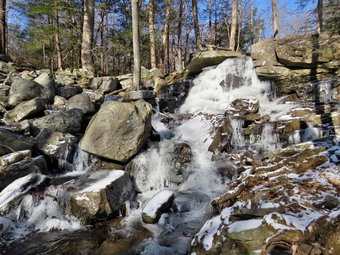
![]()
![]() On Friday, January 11th I was attending a retreat for men with members of the my church, the Vine and Branch Free Methodist Church in Liberty. The retreat was at the Spruce Lake Retreat Center in Canadensis, PA which has outstanding facilities. I had not been out hiking in 9 days as I tried to fight off a cold that was going into its fourth week! After the morning program, lunch was served at 11:230 AM and the next program did not begin until 2:30 PM. I was not hungry for a big meal and decided to take a hike to the viewpoint on Spruce Mountain. The hike followed along a small stream and was supposed to have some nice views of waterfalls. I had hoped that someone else in the group of 12 would accompany me but there were no takers. I often hike by myself but always have my dog Sheila along. I had previewed the trail after breakfast and found the Lower Falls a few hundred feet behind the main program building. The trail was gravel which made for easy walking to the falls. I had walked a little farther and found theta after the trail crossed a camp road it became a typical hiking trail with rocks, roots and ice. Before starting the actual hike, I returned to my car to change into some more appropriate hiking gear which I had brought with me. The temperature was only 18 degrees and there was a constant wind blowing so I decided to dress warmly as warmly as I could. I had no base layer but I change into my Mammut pullover which is heavier than most others I own. I already had on my Columbia Omniheat hiking pants which have a reflective lining and are heavier than my "go to" Railriders pants. The pants have Velcro closures at the ankles which means gaiters are not usually needed until the snow gets deeper. I donned my Mammut hoody which has enough zippers to dump heat if needed. I put on a heavier hat and gloves. I wore a pair of Keen Revel III boots which are insulated but not very waterproof. I had not brought a pair of hiking poles but did have a pair of Stabilicers which I thought would be a good idea on the icy trail. At 11:45 AM I returned to the program center and walked passed it and turned left just before Carroll Cottage where the trails began. I had not brought a pack but did decide to carry my camera with me. After a few hundred feet, I turned left and walked down a path to the streambed. I climbed over some debris and blowdowns to a spot in front of the falls. I had an unobstructed view of the small falls. There was plenty of water and ice making the scene beautiful. I took a number of pictures and felt fortunate that the sun was behind me. As I was taking pictures, I notice that my camera battery was almost "dead". I quickly changed to a spare battery, packed up the camera and walked back up to the main trail. I walked out to the road, turned left and then immediately right onto the Spruce Mountain trail which was blazed in yellow.
On Friday, January 11th I was attending a retreat for men with members of the my church, the Vine and Branch Free Methodist Church in Liberty. The retreat was at the Spruce Lake Retreat Center in Canadensis, PA which has outstanding facilities. I had not been out hiking in 9 days as I tried to fight off a cold that was going into its fourth week! After the morning program, lunch was served at 11:230 AM and the next program did not begin until 2:30 PM. I was not hungry for a big meal and decided to take a hike to the viewpoint on Spruce Mountain. The hike followed along a small stream and was supposed to have some nice views of waterfalls. I had hoped that someone else in the group of 12 would accompany me but there were no takers. I often hike by myself but always have my dog Sheila along. I had previewed the trail after breakfast and found the Lower Falls a few hundred feet behind the main program building. The trail was gravel which made for easy walking to the falls. I had walked a little farther and found theta after the trail crossed a camp road it became a typical hiking trail with rocks, roots and ice. Before starting the actual hike, I returned to my car to change into some more appropriate hiking gear which I had brought with me. The temperature was only 18 degrees and there was a constant wind blowing so I decided to dress warmly as warmly as I could. I had no base layer but I change into my Mammut pullover which is heavier than most others I own. I already had on my Columbia Omniheat hiking pants which have a reflective lining and are heavier than my "go to" Railriders pants. The pants have Velcro closures at the ankles which means gaiters are not usually needed until the snow gets deeper. I donned my Mammut hoody which has enough zippers to dump heat if needed. I put on a heavier hat and gloves. I wore a pair of Keen Revel III boots which are insulated but not very waterproof. I had not brought a pair of hiking poles but did have a pair of Stabilicers which I thought would be a good idea on the icy trail. At 11:45 AM I returned to the program center and walked passed it and turned left just before Carroll Cottage where the trails began. I had not brought a pack but did decide to carry my camera with me. After a few hundred feet, I turned left and walked down a path to the streambed. I climbed over some debris and blowdowns to a spot in front of the falls. I had an unobstructed view of the small falls. There was plenty of water and ice making the scene beautiful. I took a number of pictures and felt fortunate that the sun was behind me. As I was taking pictures, I notice that my camera battery was almost "dead". I quickly changed to a spare battery, packed up the camera and walked back up to the main trail. I walked out to the road, turned left and then immediately right onto the Spruce Mountain trail which was blazed in yellow.
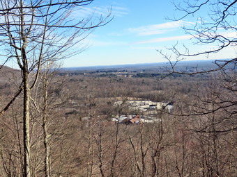 The trail did have some ice in spots and a light covering of snow. The Stabilicers seemed perfect for the trail as they offer some grip but are "flatter" than microspikes and handle walking over rocks and dirt better. After a short walk there was a sign indicating that the yellow trail had been relocated away from the stream. I decided to follow the original trail which still had blazes. I wanted to be sure I saw all the waterfalls along the stream and it seemed the new location of the trail would miss them. I followed the old trail and found that it had most likely been relocated because it was flooded by the stream. I had to cross the stream several times and was careful as the water was obviously freezing. Along the way I took pictures of several small falls waiting for the one that was designated as the Upper Falls. I finally arrived at another, larger falls but had some problems getting pictures from the north bank. I worked my way above the falls and crossed the stream to find a better viewpoint. I was able to get below the falls and take some nice pictures. I came to the conclusion that this was not the Upper Falls and crossed back over to the other side of the stream. I continued to follow the old yellow blazes and soon could see another, much higher falls. I stopped just before the trail turned up toward the top of the falls. I got out the camera and took numerous pictures of the whole falls and individual sections. When I had taken all the pictures I wanted, I turned right an tried to follow the blazes up the steep terrain to the top of the falls. When the blazes faded, I simply bushwhacked to the top and walked toward the stream where I found the trail again. The blazes continued across the stream and I found a way to bridge the water without falling in. Another "trail Relocated" sign appeared but it wasn't clear to me what it meant. I followed the trail as it began to climb up Spruce Mountain on a woods road. The sun was out but the air temperature remained the same and the wind was till blowing. Despite this, I felt warm and almost opened some zippers on the hoody. The trail had a moderate grade and several switchbacks which made the walking rather easy. I was happy to have the Stabilicers and knew I would be even happier on the descent. My plan was to hike to the viewpoint and then to continue to follow the trail down the other side of the mountain where it intersected a road. I would walk the road back to the retreat center.
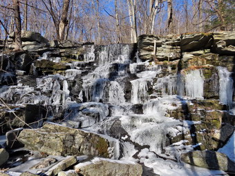 As I walked up the mountain, I kept looking for the spot where the relocated trail joined but never found it. Soon I was at the highest point on the trail. There was a view through the trees of the valley below and the mountain beyond but I was disappointed there was no open view. I did take a few pictures through the trees and then walked downhill to start the trip back. In a short distance, I noticed there was an opening on the left with a rock ledge and no trees. I had arrived at the lookout. The views were spectacular and I took pictures of the whole valley and the retreat center below. It was about 12:45 PM which meant I had been hiking for about an hour. I followed the trail along the cliffs but the yellow blazes soon disappeared and POSTED signs appeared. The signs did not have a name so I did not know whether I was still on the 888 acres owned by the Spruce Lake Retreat Center. I decided the safest approach was to return the way I came since I knew that would get me back in time for the afternoon session. I turned around and walked uphill passed the viewpoint and won the mountain. I looked up to see another hiker heading in my direction. We stopped and talked briefly. I told him about the viewpoint and then we wished each other well and continued on our separate ways. The walk downhill definitely went faster than the ascent and I was soon approaching the Upper Falls. I heard voices and looked below on the south bank to see a group of about twelve men hiking toward the falls. I watched for a minute and then continued to the falls where I saw yellow blazes that turned right descending passed the stream. I had found the trail relocation. By this time the group was making the very icy ascent to the top so I waited. I said "Hello" as they passed and noticed none had any traction devices and some did not have hiking boots! When the last person had made it to the top, I started the descent. Now I was VERY glad I had the Stabilicers. The view of the falls was better than from the other bank so I walked out to just below the falls to get some more pictures. I put down my camera and struggled to move a branch that blocked the falls. After moving the branch, I got out the camera and took a number of shots of the falls. After putting away the camera, I made my way back to the trail and continued to descend the trail. I was not impressed with the relocation as the area by the falls was dangerous and the rest of the trail was located haphazardly. The descent seemed to go quickly and I was soon back at the first "Trail Relocation" sign. I continued back on the same trail passing the Lower Falls and ending up back at the program center. It was 1:45 PM and I had hiked what I estimated was a little over 3 miles in two hours. I removed my Stabilicers and decided to go back to the car to drop the camera and Stabilicers. I wanted to contact my group but found my cell phone was dead. As I walked through the main building, I found them and explained what I was going to do. When I returned, we waited a few minutes and then decided to go to the program center for the afternoon session.
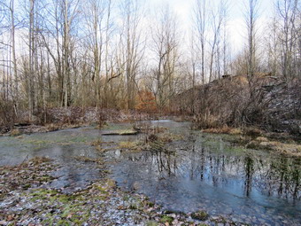
![]()
![]()
![]()
![]()
![]() On Wednesday, January 2nd I was ready for the first hike of the new year. Lisa had contacted me the night before and asked if I wanted to hike and suggested Bramley Mountain near Delhi or Utsaynantha in Stamford. Since I had to coach in the afternoon, I decided on Bramley as it is closer and more of an actual hike. Sheila seemed a little less enthusiastic than normal as I got ready to pick up Lisa at her home on the Beaverkill Road at 8:30 AM. The temperature was only 25 degrees and the high was forecast to be just short of freezing so I decided to dress warmly. I put on a long-sleeved base layer and wore my Mammut pullover which is heavier than most others I own. I put on a pair of Columbia Omniheat hiking pants which have a reflective lining and are heavier than my "go to" Railriders pants. The pants have Velcro closures at the ankles which means gaiters are not usually needed until the snow gets deeper. I donned my Mammut hoody which has enough zippers to dump heat if needed. I put on a heavier hat and gloves. I wore my Vasque Talus hiking boots instead of the Salomon B-52 winter boots since I knew that any remaining snow would be frozen and hard-packed. I wear regular hiking boots whenever I can as I feel they are a better fit and offer more support. I grabbed a pair of Leki poles with external locks that I have been using lately and made sure I had my microspikes at in my pack. I got my gear and Sheila in the car and headed up the Beaverkill Road to pick up Lisa. As soon as Sheila realized we are picking up Lisa, she began to get excited and greeted her with great enthusiasm. I drove through Lew Beach and turned left on Beech Hill Road. The road was a little rough but we are soon at Route 30. I turned right and then left over the Dunraven Bridge. I turned left on Tremperskill Road and followed it into Andes where I turned left on Route 28 North at the traffic light. After 7.5 miles, I turned right on Glen Burnie Road and drove 3.3 miles to the parking area for Bramley Mountain. The parking area is small but is well marked and it helped that we had been there before. I pulled into the parking area, turned around and parked at 9:15 AM. There were no other cars in the lot and I enticed the temperature was 24 degrees despite some sun peeking through the clouds. I set my GPS and we started to hike by getting on the blue trail that follows a woods road to the quarry. I chose this way even though I have hiked it before as we could make a steep ascent and then a moderate descent on the red trail from the summit. I didn't know how much ice there would be a preferred to encounter it on the ay up rather than on the descent. The woods road was very open and most of the water and mud was frozen. We walked along the road through the woods and I kept noticing features I had missed on previous hikes including a small pond on the left side of the trail. I had only hiked the trails in spring and summer and the absence of leaves made spotting some things easier. We eventually broke out into an open clearing where we continued toward the quarry. At about .8 miles we came to the quarry and I decided not to stop to take some pictures. When we started out again, we came to a spot where the trail seemed to split with blue markers going both left and right. There was no sign or indication which way we should go to get to the summit. I knew the answer was to bear right but first time visors might have a problem. Lisa, who had not been on the trails before, took a quick hike to the top of the left trail before joining me. We followed the main trail to the right.
On Wednesday, January 2nd I was ready for the first hike of the new year. Lisa had contacted me the night before and asked if I wanted to hike and suggested Bramley Mountain near Delhi or Utsaynantha in Stamford. Since I had to coach in the afternoon, I decided on Bramley as it is closer and more of an actual hike. Sheila seemed a little less enthusiastic than normal as I got ready to pick up Lisa at her home on the Beaverkill Road at 8:30 AM. The temperature was only 25 degrees and the high was forecast to be just short of freezing so I decided to dress warmly. I put on a long-sleeved base layer and wore my Mammut pullover which is heavier than most others I own. I put on a pair of Columbia Omniheat hiking pants which have a reflective lining and are heavier than my "go to" Railriders pants. The pants have Velcro closures at the ankles which means gaiters are not usually needed until the snow gets deeper. I donned my Mammut hoody which has enough zippers to dump heat if needed. I put on a heavier hat and gloves. I wore my Vasque Talus hiking boots instead of the Salomon B-52 winter boots since I knew that any remaining snow would be frozen and hard-packed. I wear regular hiking boots whenever I can as I feel they are a better fit and offer more support. I grabbed a pair of Leki poles with external locks that I have been using lately and made sure I had my microspikes at in my pack. I got my gear and Sheila in the car and headed up the Beaverkill Road to pick up Lisa. As soon as Sheila realized we are picking up Lisa, she began to get excited and greeted her with great enthusiasm. I drove through Lew Beach and turned left on Beech Hill Road. The road was a little rough but we are soon at Route 30. I turned right and then left over the Dunraven Bridge. I turned left on Tremperskill Road and followed it into Andes where I turned left on Route 28 North at the traffic light. After 7.5 miles, I turned right on Glen Burnie Road and drove 3.3 miles to the parking area for Bramley Mountain. The parking area is small but is well marked and it helped that we had been there before. I pulled into the parking area, turned around and parked at 9:15 AM. There were no other cars in the lot and I enticed the temperature was 24 degrees despite some sun peeking through the clouds. I set my GPS and we started to hike by getting on the blue trail that follows a woods road to the quarry. I chose this way even though I have hiked it before as we could make a steep ascent and then a moderate descent on the red trail from the summit. I didn't know how much ice there would be a preferred to encounter it on the ay up rather than on the descent. The woods road was very open and most of the water and mud was frozen. We walked along the road through the woods and I kept noticing features I had missed on previous hikes including a small pond on the left side of the trail. I had only hiked the trails in spring and summer and the absence of leaves made spotting some things easier. We eventually broke out into an open clearing where we continued toward the quarry. At about .8 miles we came to the quarry and I decided not to stop to take some pictures. When we started out again, we came to a spot where the trail seemed to split with blue markers going both left and right. There was no sign or indication which way we should go to get to the summit. I knew the answer was to bear right but first time visors might have a problem. Lisa, who had not been on the trails before, took a quick hike to the top of the left trail before joining me. We followed the main trail to the right.
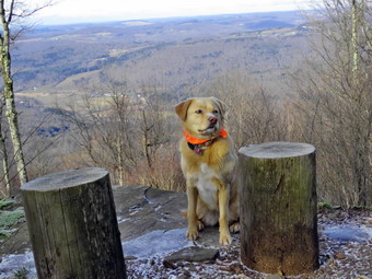 The trail entered the woods and immediately turned almost 180 degrees. As we walked along the trail it headed up the mountain at points and then shifted so that it was parallel to the ridge. There are several impressive stone walls along the way but the forest was almost completely clear of obstructions. We did find that the blazes were few and far between and we relied heavily on Sheila to show us the way. Eventually the trail turned at began a steady climb up to the summit. The trail passed by several interesting ledges and rock formations and we stopped in one spot for some pictures. There were numerous switchbacks which made the walk longer but mitigated some of the steeper climbs. Surprisingly, there was very little ice on the trails which made the walk easier than I had expected. Near the top the trail passed around and went through some rock ledges and the trail crew had expertly created some steps out of natural materials. Three times the trail crossed woods roads that climbed the mountain. At 1.9 miles and just before the summit we stopped at a nice viewpoint. The valley below was illuminated by some sunlight and the views were clear. I took a few pictures including some of Sheila before we hiked the last few hundred feet to the top. Over the 1.1 miles from the quarry we gained over 800 feet with and overall average grade of 14% despite the many switchbacks. When we reached the summit, I saw all four of the old pilings for the fire tower and hoped that the rumors about reconstructing the tower were true. We walked over to the rock ledges that form a lookout and down to the edge of a small cliff. There was more haze than I had hoped for and almost no clouds but I took some shots anyway. To the south and southeast I could see the Pisgahs near Andes which were once the site of a ski area. I walked down to the lower part of the lookout and took a few more pictures. When I was finished, I returned to the summit where I had a drink and gave Sheila some water. We walked in the direction that the arrow pointed and found the markers for the red Summit Trail that we would take back to the parking area.
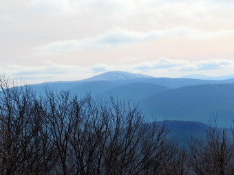 We started down the Summit Trail which starts out as wide woods road but at .15 miles from the summit markers clearly indicated a right turn. The trail follows another woods road and we immediately ran into a huge blowdown which blocked the trail. We went off the trail through some briars to avoid the tree. There was a nice view off to the left but it was not much different than the view from the summit. I did take a few pictures of the trail along the ridge. We continued to follow the woods road as it entered the woods and led out to the upper parking area. A major blowdown which had completely blocked the trail was absent. I was watching for the trail to turn right into the woods to connect to the lower parking area but somehow missed it. We walked back up the trail a few feet and turned left where the trail entered the woods and started downhill to the car. This part of the trail was soft and easy walking but only lasted .15 miles. We were soon back at the car. It was 11:45 AM and we had hiked 3.6 miles in just under 2 and a half hours. The elevation gain was 1025 feet. To get to the summit the red Summit Trail is both shorter and easier. The blue Quarry Trail and its extension is harder but also more interesting! On the way home we headed toward Delhi and crossed the stream at Fitches Crossing. Once we were in Delhi, I followed familiar route home over Telford Hollow and through Downsville.
![]()
![]()
![]()
![]() On Monday, December 31st I had planned to get in a longer hike perhaps near Alder Lake. Once again Brad and I went on an ambulance call in the middle of the night. This one was to a remote location and the patient was uncooperative. What should have been a two hour call turned into almost three hours. I did not get back to bed until 4:00 AM and slept until almost 10:00 AM. The temperature outside registered as 37 degrees but it seemed colder due to the moisture in the air and a persistent wind. I didn't even feel like going across the street to hike but Sheila's enthusiasm prevailed. At about noon Brad and I started to get ready with Sheila acting like she hadn't been out in a month! I put on a short-sleeved base layer and wore my Mammut pullover which is heavier than most others I own. I put on a pair of Columbia Omniheat hiking pants which have a reflective lining and are heavier than my "go to" Railriders pants. The pants have Velcro closures at the ankles which means gaiters are not usually needed until the snow gets deeper. I donned my Mammut hoody which has enough zippers to dump heat if needed. I put on a light hat and light gloves. I wore my Vasque Talus hiking boots instead of the Salomon B-52 winter boots since I knew that any remaining snow would be frozen and hard-packed. I wear regular hiking boots whenever I can as I feel they are a better fit and offer more support. I grabbed a pair of Leki poles with external locks that I have been using lately but chose to leave my microspikes at home. At 12:20 PM Sheila and I walked out the door to wait for Bard. I got Sheila's from my car and saw that Brad as coming out with his dog, Pierce, on his leash. I was happy to see this as I knew Pierce would always like to come with us. Both dogs were eager to go and pulled us up the slippery driveway. I decided we would try to do at least two figure 8's which might be enough given the situation. I aimed to hike for about an hour. Sheila was happy to get out as we headed down the driveway and across the street. We crossed the street with the dogs on their leashes and walked to the back of the church. We began the ascent of the steepest hill behind the church which was icy ion spots. The hill is short but gets the circulation pumping and is the steepest and longest climb on the "trail." There was almost no snow in the field and only a little on the ascent up the hill. Sheila helped me along by pulling me up the hill. When we got to the top of the hill, we started on the trail by turning left at the trailhead. I let Sheila off her leash, and she began to explore the trail with her nose. As we followed the trail, I noticed there was a light covering of snow and that there were footprints in it. I am always happy to see that someone else uses the trails. At the first trail junction, I followed Sheila as she turned right on the woods road which is the shallower approach to the trail system. We continued to follow the yellow trail to the first junction where we turned left and followed it to the next trail junction. There was one blowdown across the trail which would require an axe to clear.
On Monday, December 31st I had planned to get in a longer hike perhaps near Alder Lake. Once again Brad and I went on an ambulance call in the middle of the night. This one was to a remote location and the patient was uncooperative. What should have been a two hour call turned into almost three hours. I did not get back to bed until 4:00 AM and slept until almost 10:00 AM. The temperature outside registered as 37 degrees but it seemed colder due to the moisture in the air and a persistent wind. I didn't even feel like going across the street to hike but Sheila's enthusiasm prevailed. At about noon Brad and I started to get ready with Sheila acting like she hadn't been out in a month! I put on a short-sleeved base layer and wore my Mammut pullover which is heavier than most others I own. I put on a pair of Columbia Omniheat hiking pants which have a reflective lining and are heavier than my "go to" Railriders pants. The pants have Velcro closures at the ankles which means gaiters are not usually needed until the snow gets deeper. I donned my Mammut hoody which has enough zippers to dump heat if needed. I put on a light hat and light gloves. I wore my Vasque Talus hiking boots instead of the Salomon B-52 winter boots since I knew that any remaining snow would be frozen and hard-packed. I wear regular hiking boots whenever I can as I feel they are a better fit and offer more support. I grabbed a pair of Leki poles with external locks that I have been using lately but chose to leave my microspikes at home. At 12:20 PM Sheila and I walked out the door to wait for Bard. I got Sheila's from my car and saw that Brad as coming out with his dog, Pierce, on his leash. I was happy to see this as I knew Pierce would always like to come with us. Both dogs were eager to go and pulled us up the slippery driveway. I decided we would try to do at least two figure 8's which might be enough given the situation. I aimed to hike for about an hour. Sheila was happy to get out as we headed down the driveway and across the street. We crossed the street with the dogs on their leashes and walked to the back of the church. We began the ascent of the steepest hill behind the church which was icy ion spots. The hill is short but gets the circulation pumping and is the steepest and longest climb on the "trail." There was almost no snow in the field and only a little on the ascent up the hill. Sheila helped me along by pulling me up the hill. When we got to the top of the hill, we started on the trail by turning left at the trailhead. I let Sheila off her leash, and she began to explore the trail with her nose. As we followed the trail, I noticed there was a light covering of snow and that there were footprints in it. I am always happy to see that someone else uses the trails. At the first trail junction, I followed Sheila as she turned right on the woods road which is the shallower approach to the trail system. We continued to follow the yellow trail to the first junction where we turned left and followed it to the next trail junction. There was one blowdown across the trail which would require an axe to clear.
At the second junction with the blue trail, we turned right and started up the steep blue trail that leads over the summit of Round Top. This section of the trail faces west and north so there was more snow but I was able to get a grip with little or no problem. We walked across the flat summit of Round Top and started down the other side. Descending on the snow and frozen ground proved to be more of a challenge than I had expected but we were soon back at the yellow trail. We turned right and walked the yellow trail to the next trail junction. Here we turned left and followed the yellow trail downhill to the lookout. There wasn't much to see at the lookout as the skies were overcast. We followed the yellow trail as it turned left and descended the hill to the first trail junction. The walk had gone quickly, so we turned around and started back up the hill back to the lookout. {Pierce was definitely enjoying his walk in the woods! Sometimes Sheila resists another loop but this time she was in the lead. We followed the yellow trail uphill toward the next trail junction. At the junction, we turned right and followed the yellow trail which was covered in snow to the next junction. We turned left and started uphill on the blue trail. This side of the hill was slippery going up with frozen ground and hard-packed snow. We crested the hill and walked across the summit and started down the other side. I slipped and slid to the trail junction where we turned left. We walked along the yellow trail to the next trail junction where we turned right and walked down to the woods road and out to the first trail junction. I was feeling pretty fresh but decided to head back home as we had hiked for about an hour. Sheila was well-behaved and stayed with us most of the time. Pierce seemed to walk well on his leash without pulling Brad too much. We walked out to the trailhead where I put Sheila on her leash, and we walked down the cemetery hill. We walked across the field to our driveway. It was 1:40 PM, and we had hiked about 2 miles.
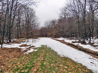
![]()
![]()
![]()
![]()
![]() On Saturday, December 29th I wanted to get in a slightly longer hike close to home since I had been limiting my outdoor activity due to a cold. My son-in-law Brad was at the house and wanted to go with me. We had been on an ambulance call in the middle of the night and slept late to get some much needed rest. It had rained almost all day on Friday and I wanted to pick a hike where I knew the trails would not be covered in water and mud. I decided we would go to the Frick Pond area and hike the Flynn Trail to Hodge Pond. This trail drains well and is usually relatively dry compared to the other trails ion the area. We didn't start getting ready to go until about 11:00 Am when the temperature was 37 degrees. The skies were completely overcast and there was a stiff breeze which made it feel colder. I put on a short-sleeved base layer and wore my Mammut pullover which is heavier than most others I own. I put on a pair of Columbia Omniheat hiking pants which have a reflective lining and are heavier than my "go to" Railriders pants. The pants have Velcro closures at the ankles which means gaiters are not usually needed until the snow gets deeper. I donned my Mammut hoody which has enough zippers to dump heat if needed. I put on a light hat and light gloves. I wore my Vasque Talus boots which are all leather and seem to be waterproof although not very warm. Sheila kept me in sight as I got ready to go making sure she would not be forgotten. We got our gear and Sheila in the car at about 11:20 AM and headed out the DeBruce Road to Mongaup Pond Road. As I drove we noticed a few flakes hitting the windscreen. I turned left and headed up toward Mongaup Pond but stayed to the left on Beech Mountain Road where the road forks. When we arrived at the parking area there was one car in the smaller lot and one in the larges. I parked in the smaller parking area and we both noticed an additional sprinkling of snow. I set my GPS unit at the trailhead and we crossed the road to start the hike at 11:45 AM. The skies were completely overcast and the wind was blowing making the 33 degree air temperature seem even cooler. On the first part of the trail through the woods, there was one large blowdown which we passed under. We turned right on the woods road which was once the extension of the Beech Mountain Road and started the 1.7 mile climb up the Flynn Trail to the junction with the Big Rock Trail. We began picking up loose branches that had fallen on the trail and continued to do so for the entire hike. The grass was wet and the rocks were slippery to step on. There was only a little snow here and there but there was ample evidence that there had been a lot of water running down the trail during the rain the day before. Sheila was roaming around running up and down the rail as Brad and I talked about EMS issues. We passed through the "tunnel" Cindy, and I had cut in a large hemlock tree that had fallen across the trail. As we hiked passed the path to the cleared area near the top of the hill, we remarked about the increased amount of "stuff" falling from the sky. Some of this was rain, some was sleet and some was snow. We hiked the 1.7 miles uphill in less than 50 minutes.
On Saturday, December 29th I wanted to get in a slightly longer hike close to home since I had been limiting my outdoor activity due to a cold. My son-in-law Brad was at the house and wanted to go with me. We had been on an ambulance call in the middle of the night and slept late to get some much needed rest. It had rained almost all day on Friday and I wanted to pick a hike where I knew the trails would not be covered in water and mud. I decided we would go to the Frick Pond area and hike the Flynn Trail to Hodge Pond. This trail drains well and is usually relatively dry compared to the other trails ion the area. We didn't start getting ready to go until about 11:00 Am when the temperature was 37 degrees. The skies were completely overcast and there was a stiff breeze which made it feel colder. I put on a short-sleeved base layer and wore my Mammut pullover which is heavier than most others I own. I put on a pair of Columbia Omniheat hiking pants which have a reflective lining and are heavier than my "go to" Railriders pants. The pants have Velcro closures at the ankles which means gaiters are not usually needed until the snow gets deeper. I donned my Mammut hoody which has enough zippers to dump heat if needed. I put on a light hat and light gloves. I wore my Vasque Talus boots which are all leather and seem to be waterproof although not very warm. Sheila kept me in sight as I got ready to go making sure she would not be forgotten. We got our gear and Sheila in the car at about 11:20 AM and headed out the DeBruce Road to Mongaup Pond Road. As I drove we noticed a few flakes hitting the windscreen. I turned left and headed up toward Mongaup Pond but stayed to the left on Beech Mountain Road where the road forks. When we arrived at the parking area there was one car in the smaller lot and one in the larges. I parked in the smaller parking area and we both noticed an additional sprinkling of snow. I set my GPS unit at the trailhead and we crossed the road to start the hike at 11:45 AM. The skies were completely overcast and the wind was blowing making the 33 degree air temperature seem even cooler. On the first part of the trail through the woods, there was one large blowdown which we passed under. We turned right on the woods road which was once the extension of the Beech Mountain Road and started the 1.7 mile climb up the Flynn Trail to the junction with the Big Rock Trail. We began picking up loose branches that had fallen on the trail and continued to do so for the entire hike. The grass was wet and the rocks were slippery to step on. There was only a little snow here and there but there was ample evidence that there had been a lot of water running down the trail during the rain the day before. Sheila was roaming around running up and down the rail as Brad and I talked about EMS issues. We passed through the "tunnel" Cindy, and I had cut in a large hemlock tree that had fallen across the trail. As we hiked passed the path to the cleared area near the top of the hill, we remarked about the increased amount of "stuff" falling from the sky. Some of this was rain, some was sleet and some was snow. We hiked the 1.7 miles uphill in less than 50 minutes.
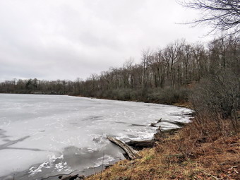 We continued on the Flynn Trail toward Hodge Pond and passed through the gate that marks the beginning of the OSI property. At the junction with the jeep trail, we turned left to walk the Flynn Trail toward Hodge Pond. Just after this intersection was an expanse of snow several inches deep was surprising since there was little snow anywhere else. We stopped so that I could take some pictures of this patch of snow and some of the bare trails we had hiked/ At 2.4 miles we broke into the clearing at the southern end of Hodge Pond where we turned left to stay on the Flynn Trail. I knew the this would be the wettest part of the trail. We walked along the woods road which opens into a field where there were several puddles. When we entered the woods again, there were ruts in the mud on the road and these were filled with water. We skirted the mess by walking along the sides of the trail until we came to the point where the Flynn Trail head up the hill. We stayed right to walk the jeep trail around the back of the pond. I had not intended to take pictures, but as we rounded the back of the pond I decided to walk the path down to the shore. I was surprised that the pond was completely frozen over even after the warm weather and rain. We walked down to the shore and Sheila went to the edge of the pond but walk out onto the ice. I took out the camera and took some shots of the pond, the bleak landscape and overcast sky. Back on the trail, we walked up a hill and then down to the field at the southern end of the pond. We walked over toward the shore and stopped so that I could take pictures of what was now a bleak scene with dark skies. After I took a few shots, we turned to walk to the point where the Flynn Trail reenters the woods. The walk up the Flynn Trail can seem long, but we made an extra effort to hurry up the hill as the clouds gathered and more snow started to fall. The trail was a little longer than I remembered but not as steep, and we were soon at the top of the hill. We continued straight ahead to the junction with the Big Rock Trail. We hiked passed the gate and by 1:45 PM we were back at the highest point on the hike after hiking 4.1 miles. The Flynn Trail is all downhill on the way back, and we set a pretty fast pace. I did have to keep calling Sheila back as she was setting an even faster pace. As we were starting on the last part of the trail, it began to snow pretty hard and in a short time the ground was starting to get covered. Soon we were descending the last part of the hill to the gate. We followed the Flynn Trail through the woods and back to the car. Along the way we looked up to find a couple walking toward us. I put Sheila on her leash as the others passed. The skies were dark, and the wind was blowing indicating to me that more snow was on the way. Surprisingly the descent had taken only a few minutes less than the ascent, and we had made no stops. We were back at the car at 2:30 PM having hiked 5.8 miles in 2 hours and 40 minutes gaining 875 feet along the way.
![]()
![]()
![]()
![]() On Thursday, December 27th I wanted to get out for a hike after almost two weeks of inactivity! Late December can be a difficult time to hike because of all the family and church commitments but for the last few years this has been exacerbated by some kind of sickness. This time I had a cold accompanied lung complications and I chose to take it easy rather than to push myself. This made me feel better physically, I think, but was mentally devastating. When I suggested to Sheila that we go "out" for a "hike" she instantly became crazed and would not leave my sight while whining all the time. I decided that I would start easy and go across the street to hike on Round Top. The temperature was 30 degrees as I got ready to hike around noon but the sun was shining. The forecast for Friday was for temperatures in the high 40's accompanied by rain for most of the day. I put on a long-sleeved base layer and wore my Mammut pullover which is heavier than most others I own. I put on a pair of Columbia Omniheat hiking pants which have a reflective lining and are heavier than my "go to" Railriders pants. The pants have Velcro closures at the ankles which means gaiters are not usually needed until the snow gets deeper. I donned my Mammut hoody which has enough zippers to dump heat if needed. I put on a light hat and light gloves. I wore my Vasque Talus boots which are all leather and seem to be waterproof although not very warm. At 12:30 PM we walked out the door and up the driveway. I put Sheila on her leash, and she pulled me up the driveway knowing exactly where we were going. There was only a light covering of snow but there were patches of ice which made the going slippery. I knew snowshoes were out of the questions and I decided that spikes would be a bigger problem than an advantage. I decided we would do some figure 8's just for the exercise and to take a look at the condition of the trails. I aimed to hike for about an hour. We crossed the street with Sheila on her leash and walked to the back of the church. We began the ascent of the steepest hill behind the church. The hill is short but gets the circulation pumping and is the steepest and longest climb on the "trail." Sheila helped me along by pulling me up the hill. When we got to the top of the hill, I paused for a moment to enjoy the bright sun. We started on the trail by turning left at the trailhead. I let Sheila off her leash, and she began to explore the trail with her nose. As we followed the trail, I noticed it was completely frozen and that there was some snow remaining.
On Thursday, December 27th I wanted to get out for a hike after almost two weeks of inactivity! Late December can be a difficult time to hike because of all the family and church commitments but for the last few years this has been exacerbated by some kind of sickness. This time I had a cold accompanied lung complications and I chose to take it easy rather than to push myself. This made me feel better physically, I think, but was mentally devastating. When I suggested to Sheila that we go "out" for a "hike" she instantly became crazed and would not leave my sight while whining all the time. I decided that I would start easy and go across the street to hike on Round Top. The temperature was 30 degrees as I got ready to hike around noon but the sun was shining. The forecast for Friday was for temperatures in the high 40's accompanied by rain for most of the day. I put on a long-sleeved base layer and wore my Mammut pullover which is heavier than most others I own. I put on a pair of Columbia Omniheat hiking pants which have a reflective lining and are heavier than my "go to" Railriders pants. The pants have Velcro closures at the ankles which means gaiters are not usually needed until the snow gets deeper. I donned my Mammut hoody which has enough zippers to dump heat if needed. I put on a light hat and light gloves. I wore my Vasque Talus boots which are all leather and seem to be waterproof although not very warm. At 12:30 PM we walked out the door and up the driveway. I put Sheila on her leash, and she pulled me up the driveway knowing exactly where we were going. There was only a light covering of snow but there were patches of ice which made the going slippery. I knew snowshoes were out of the questions and I decided that spikes would be a bigger problem than an advantage. I decided we would do some figure 8's just for the exercise and to take a look at the condition of the trails. I aimed to hike for about an hour. We crossed the street with Sheila on her leash and walked to the back of the church. We began the ascent of the steepest hill behind the church. The hill is short but gets the circulation pumping and is the steepest and longest climb on the "trail." Sheila helped me along by pulling me up the hill. When we got to the top of the hill, I paused for a moment to enjoy the bright sun. We started on the trail by turning left at the trailhead. I let Sheila off her leash, and she began to explore the trail with her nose. As we followed the trail, I noticed it was completely frozen and that there was some snow remaining.
At the first trail junction, I followed Sheila as she continued straight ahead up the hill toward the lookout. We followed the yellow blazes up to the viewpoint and then turned right to follow the trail uphill a little toward the next trail junction. At the junction, we turned right to follow the yellow trail along the base of Round Top. I was pleased to see several sets of footprints. One set was so fresh I thought we might meet the hiker as we walked! At the next trail junction, we turned left on the blue trail and walked up toad the summit of Round Top. The trail was a little slippery but we were soon walking across the summit plateau. We started down the steeper side which was also slippery as it has retained more snow. Once we got to the yellow trail, we turned right and walked to the trail junction again. This time we turned right and followed the trail down to the woods road. We walked downhill on the woods road to the first trail junction finding one tree across the trail. When we arrived at the first trail junction, I was feeling pretty fresh so we turned around and started back up the more gentle slope we had just descended. We followed the yellow blazes up the woods road to the next trail junction where we turned left to walk along the base of Round Top. At the next junction with the blue trail, we turned right and began the ascent of the snow covered hill which is the steepest part of the hike. At the top we crossed the summit and descended back to the yellow trail. We turned right and again walked along the base of the hill to the next trail junction. This time we turned left and walked down the hill on the yellow trail to the lookout. We followed the yellow trail to the left and walked down the hill to the first trail junction. My chest was hurting a little from the cold air and I decided that I was satisfied with what we had done. We continued straight ahead on the yellow trail to the trailhead. Sheila was well-behaved and stayed with me most of the time. I put Sheila on her leash and we walked down the cemetery hill. We walked across the field to our driveway. It was 12:35 PM and we had hiked a little over 2 miles in an hour.