
What You Missed
Summer 2023
Summer 2023
![]()
![]()
![]()
![]()
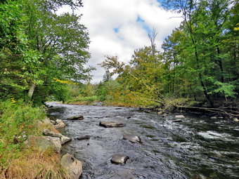
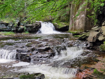
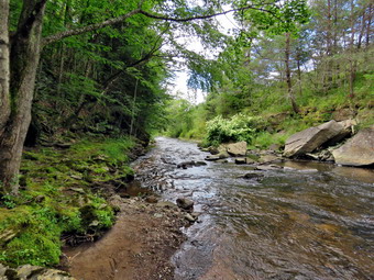
![]() On Tuesday, September 19th, Cindy and I had out district pastors' meetings at 10:00 AM in Walton. The meeting went well, as always, and we were home by 1:30 PM. I wanted to get out for a hike someplace I had not been in some time. I asked Cindy if she would like to go to the Beaverkill Campgrounds since they were closed and soul be empty. Getting away even for an hour improves my mood and my physical health. The skies were blue with puffy white clouds and the temperature was just 70 degrees. Cindy agreed to go as the hike is along the river and is almost flat. We started to get ready and noticed Sheila was certainly happy to go hiking. I decided to wear my White Sierra long-sleeved crew shirt without a baselayer. I wore my Railriders hiking pants which are expensive but last along time and have features like deep pockets and a generous cut which I really like. The pants have Velcro closures at the ankles. I decided to put on my new Keen Durand hiking boots which I ordered a half size larger than the previous pair. These shoes fit well out of the box but get much tighter when I add a decent insole. Without the third party insole, by feet hurt from the lack of support. I added a new pair of Xstance insoles in an effort to find the best support and cushioning for my feet. These insoles have shock absorbing gel pads, TPU arch support, and memory foam cushioning all wrapped in a breathable fabric. The insoles have been hyped by their manufacturer and they really do seem to deliver. I decided to take my Leki poles with external locks as the internal twist locks sometimes fail. I did not put on any gaiters even though numerous ticks had plagued us on previous hikes. We left the house at 2:00 PM as I drove out Old Route 17 toward Roscoe and turned right on Beaverkill Road. As we started the descent into the Beaverkill Valley, I turned left on Campsite Road and followed it down to the parking area near the Beaverkill Covered Bridge. There were no cars parked in the lot. A glance at the river showed that the level was high enough to be interesting. The temperature was 70 degrees as we got ready to begin our hike.
On Tuesday, September 19th, Cindy and I had out district pastors' meetings at 10:00 AM in Walton. The meeting went well, as always, and we were home by 1:30 PM. I wanted to get out for a hike someplace I had not been in some time. I asked Cindy if she would like to go to the Beaverkill Campgrounds since they were closed and soul be empty. Getting away even for an hour improves my mood and my physical health. The skies were blue with puffy white clouds and the temperature was just 70 degrees. Cindy agreed to go as the hike is along the river and is almost flat. We started to get ready and noticed Sheila was certainly happy to go hiking. I decided to wear my White Sierra long-sleeved crew shirt without a baselayer. I wore my Railriders hiking pants which are expensive but last along time and have features like deep pockets and a generous cut which I really like. The pants have Velcro closures at the ankles. I decided to put on my new Keen Durand hiking boots which I ordered a half size larger than the previous pair. These shoes fit well out of the box but get much tighter when I add a decent insole. Without the third party insole, by feet hurt from the lack of support. I added a new pair of Xstance insoles in an effort to find the best support and cushioning for my feet. These insoles have shock absorbing gel pads, TPU arch support, and memory foam cushioning all wrapped in a breathable fabric. The insoles have been hyped by their manufacturer and they really do seem to deliver. I decided to take my Leki poles with external locks as the internal twist locks sometimes fail. I did not put on any gaiters even though numerous ticks had plagued us on previous hikes. We left the house at 2:00 PM as I drove out Old Route 17 toward Roscoe and turned right on Beaverkill Road. As we started the descent into the Beaverkill Valley, I turned left on Campsite Road and followed it down to the parking area near the Beaverkill Covered Bridge. There were no cars parked in the lot. A glance at the river showed that the level was high enough to be interesting. The temperature was 70 degrees as we got ready to begin our hike.
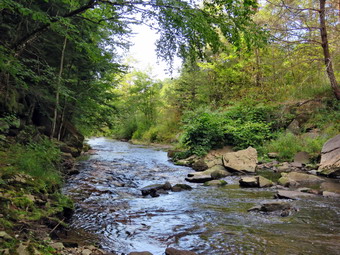
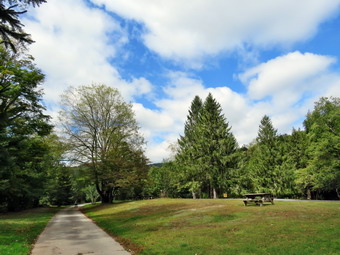 We started out at 2:25 PM by walking out of the parking lot to the bridge with the temperature at 70 degrees. The skies were bright blue with puffy white clouds. When we got to the other side, the gate just off the road was closed as the campgrounds had closed September 5. I looked at the trail and saw that it was a little damp but not muddy. We turned left on a woods road that parallels the river and started down a short hill. We passed the spring house and continued on the deserted woods road. We came to an area with a little path down to the river. Just passed this area the trail had been eroding due to the water running down the bank. The DEC had replaced a culvert pipe and installed a second. They had also brought in fill and packed it to reconstruct the path. I found this interesting as the campsites along this path are no longer used and are abandoned. I walked down to the edge of the river very carefully as the rocks were slippery and the water looked deep and cold. I took some pictures downstream and some upstream to the bridge although the leaves on the trees were hiding most of the covered bridge. There were several places where trees at the edge of the river had fallen into the water testifying to the power of the river when it is high. Some of the leaves were beginning to change which add color to the pictures. When I was done, we got back on the trail and passed several areas with unused picnic tables. The state had mowed around many of the tables so that they could be used by people who wanted to picnic. Others sat unused and rotting along the road, a testimony to better days. We walked by these tables which had not been used in many years. I could not resist stopping to take some pictures of the trails and the picnic tables with absolutely no one around except us! A little later we came to what was once a bathroom for some campsites that had long since disappeared. There were more tables in this area. There was a path over to the river so I walked over and found the water was sparkling in the sun and was very clear. I took some pictures of the sun reflecting off the water both upstream and downstream. I also took some pictures of the bathroom that was slowly rotting away.
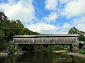 At about .7 miles the woods road met the paved road that serves the campsites. We continued on the road through the campsites and along the river. The campsites were all empty and I took pictures of the solitude. I took several pictures of the tall trees against the blue skies. We walked to the last campsite where the road ends and Sheila and I walked down to the edge of the river. I was careful to watch where I was walking but the water was low and warm. I stopped to take some pictures of the river especially downstream. Sheila decided to take a dip in the water but did not wait for me to take pictures of her. We continued along the shore a little further passed the last campsite and I took some more shots before walking up to the campsite and back to where Cindy was standing. I stowed my camera and picked up the pack. We walked back from the last campsite, staying to the left of the last bathroom to walk back on the other paved road through the campsites. This road parallels the one we walked out on to make a sort of loop. We retuned the way we had come although at a quicker pace. As we approached the bridge, I saw that there were two cars parked in the lot with three people talking. We walked through the bridge and turned right to go back to the car. Sheila and Cindy got into the car and I stowed my pack but retrieved my camera. I walked down to the shore of the stream and out onto a rock that sticks out into the Beaverkill. I took some shots downstream and then turned my attention to the bridge. I took some shots of the whole bridge and some close-ups of the abutments and the center portion. I returned to the car at 3:40 PM having hiked 2.7 miles in 1 hour and 15 minutes. The car's thermometer read 72 degrees.
![]()
![]()
![]()
![]() On Sunday, September 17th I planned to get out for a hike after returning from church. The temperature was 68 degrees and I asked Cindy if she would like to go across the street to hike on Round Top. Cindy declined but Sheila was very enthusiastic. She was keeping a careful eye on me as I dressed. I decided to wear my White Sierra long-sleeved crew shirt without a baselayer. I wore my Railriders hiking pants which are expensive but last along time and have features like deep pockets and a generous cut which I really like. The pants have Velcro closures at the ankles. I decided to put on my new Keen Durand hiking boots which I ordered a half size larger than the previous pair. These shoes fit well out of the box but get much tighter when I add a decent insole. Without the third party insole, by feet hurt from the lack of support. I added a new pair of Xstance insoles in an effort to find the best support and cushioning for my feet. These insoles have shock absorbing gel pads, TPU arch support, and memory foam cushioning all wrapped in a breathable fabric. The insoles have been hyped by their manufacturer and they really do seem to deliver. I decided to take my Leki poles with external locks as the internal twist locks sometimes fail. I did not put on any gaiters even though numerous ticks had plagued us on previous hikes. At 1:25 PM we walked out the door to start the hike. I grabbed Sheila's leash from my car and put it on her as we walked up the driveway. I aimed to hike for about an hour depending on how I felt. I had left my pager and phone at home so that I could have some time without worrying about ambulance calls! Sheila was happy to get out as we headed down the driveway and across the street. We crossed the street and walked to the parking lot next to the Presbyterian Church. We walked to the back of the church and began the ascent of the steepest hill behind the church. The hill is short but gets the circulation pumping and is the steepest and longest climb on the "trail." Even though I had not been hiking much, I made it to the top without stopping. At the top of the hill we paused for a minute so I could look around at the hills that surround the hamlet of Livingston Manor. The skies were blue with a few white clouds. The trees all around us were beginning to turn colors and some leaves were falling. I had decided not to bring my pack just to carry my camera. I was a little sorry I did not have the camera as there were some good photographic opportunities. We continued the hike by turning left at the trailhead. The trail was bare but damp in a few places.
On Sunday, September 17th I planned to get out for a hike after returning from church. The temperature was 68 degrees and I asked Cindy if she would like to go across the street to hike on Round Top. Cindy declined but Sheila was very enthusiastic. She was keeping a careful eye on me as I dressed. I decided to wear my White Sierra long-sleeved crew shirt without a baselayer. I wore my Railriders hiking pants which are expensive but last along time and have features like deep pockets and a generous cut which I really like. The pants have Velcro closures at the ankles. I decided to put on my new Keen Durand hiking boots which I ordered a half size larger than the previous pair. These shoes fit well out of the box but get much tighter when I add a decent insole. Without the third party insole, by feet hurt from the lack of support. I added a new pair of Xstance insoles in an effort to find the best support and cushioning for my feet. These insoles have shock absorbing gel pads, TPU arch support, and memory foam cushioning all wrapped in a breathable fabric. The insoles have been hyped by their manufacturer and they really do seem to deliver. I decided to take my Leki poles with external locks as the internal twist locks sometimes fail. I did not put on any gaiters even though numerous ticks had plagued us on previous hikes. At 1:25 PM we walked out the door to start the hike. I grabbed Sheila's leash from my car and put it on her as we walked up the driveway. I aimed to hike for about an hour depending on how I felt. I had left my pager and phone at home so that I could have some time without worrying about ambulance calls! Sheila was happy to get out as we headed down the driveway and across the street. We crossed the street and walked to the parking lot next to the Presbyterian Church. We walked to the back of the church and began the ascent of the steepest hill behind the church. The hill is short but gets the circulation pumping and is the steepest and longest climb on the "trail." Even though I had not been hiking much, I made it to the top without stopping. At the top of the hill we paused for a minute so I could look around at the hills that surround the hamlet of Livingston Manor. The skies were blue with a few white clouds. The trees all around us were beginning to turn colors and some leaves were falling. I had decided not to bring my pack just to carry my camera. I was a little sorry I did not have the camera as there were some good photographic opportunities. We continued the hike by turning left at the trailhead. The trail was bare but damp in a few places.
We passed by all the places where I had cut trees to remove them from the trail. At the first trail junction, I followed Sheila as she turned right and started up the woods road which has the gentler approach of the two. There were a few branches on the trail from the winds that had passed through the area. I removed these branches either by dragging them off the trail or by using my poles on the smaller ones. It was a pleasure to walk on the trails and it was obvious more people were using them. We reached the end of the woods road and turned left up the hill on the trail. I could see the frame and tarps that covered the mouth of one of the "caves". They were looking ragged as if no one had used them for some time. We continued up the trail to the first trail junction with the upper blue trail and turned left to follow the yellow trail along the base of Round Top. There were only a few new branches here and there on the trail. I stopped to remove the branches or used my poles to flick the smaller ones aside. There were also two small trees across the trail. I tried to move them but they were well-anchored and I knew I would have to return with tools to take care of them. I was getting warmer as we hiked even though the temperatures was in the mid 60's. At the next junction with the blue trail we turned right and headed up the blue trail toward the summit. When we got to the switchback, we turned right and followed it until it came back to the main blue trail. The fact that the switchback sidehills in places made the walk a little more difficult. We turned right and then continued straight ahead and up the hill toward the summit of Round Top bypassing the white crossover trail. As we walked over the high point, I removed a couple of branches off the trail. We continued over the summit and down the blue trail toward the junction with the yellow trail. We bypassed the white crossover trail again and continued down to the yellow trail. At the junction with the yellow trail we turned right and walked the yellow trail along the base of Round Top to the next junction with the blue trail. Jumping over the small trunks across the trail was no problem for us but I knew some people would find them difficult. We turned left and started slightly downhill toward the lookout over town.
Again, I regretted leaving my camera home as there were some pretty views down to town and the school from the viewpoint. There were also some nice views of the hills around town. We followed the yellow trail as it turned left and descended the steep hill back to the first trail junction. The descent went quickly even though the leaves were damp and a little slippery. When we got to the first trail junction, I checked my watch. I decided we had time to turn around to do another loop. Sheila seemed pleased as she dashed ahead of me up the hill. For me, the ascent was definitely more difficult than the descent! At the top of the hill we followed the trail as it turned right and headed uphill toward the junction with the blue trail. We hiked up a short but steep little hill and arrived at the trail junction. We turned right to follow the trail along the base of Round Top. Sheila was some distance ahead when she came roaring back at me at full speed. She passed me, made a 180 degree turn, and came running back. She repeated this several times before I called her off. We vaulted over the trunks across the trail and at the next junction with the blue trail we turned left and walked the blue trail toward the summit. We continued over the summit on the blue trail and headed down the other side. We turned left on the switchback and followed it out into the forest and then back to the main trail. We turned left and walked downhill to the yellow trail where a left turn again took us along the base of Round Top. At the junction, we turned right and walked down the trail to the woods road. We followed the woods road downhill with the ledges to the right. At the first trail junction, we turned left and walked straight out to the trailhead. We turned right and walked downhill crossing the road and walking through the church parking lot. We waited to cross the road as several cars went by and then crossed to the driveway to the house. It was 2:35 PM and we had hiked a little over 2 miles in a an hour and 10 minutes.
![]()
![]()
![]()
![]()
![]() On Friday, September 15th I wanted to get out for a hike after 10 days of ambulance calls, bad weather and church commitments; not necessarily in that order. I went to church to prepare for the Sunday service and returned ready to go for a hike wife Cindy. Cindy was not home so Sheila and I waited until she returned. I decided I would go to the Parksville Rail Trail for a quick hike as I wanted to see what the recent rains had done to the volume of the stream and the dalls. I asked Cindy if she would like to go along and she said "Yes". I think we both felt it would be a good day to hike as the temperature was 76 degrees and the humidity was low with a slight breeze. The skies were blue with some sun and some nice white clouds. We started to get ready at 3:30 PM with Sheila keeping a watchful eye on both of us. The Parksville Rail Trail is about 2.5 miles with a beautiful waterfall. I decided to leave my pager and phone home as I knew others were around to respond and I need a break. As we were getting dressed it looked as if Sheila thought we might not hike again! I decided to wear my White Sierra long-sleeved crew shirt without a baselayer. I wore my Railriders hiking pants which are expensive but last along time and have features like deep pockets and a generous cut which I really like. The pants have Velcro closures at the ankles. I decided to put on my new Keen Durand hiking boots which I ordered a half size larger than the previous pair. These shoes fit well out of the box but get much tighter when I add a decent insole. Without the third party insole, by feet hurt from the lack of support. I added a new pair of Xstance insoles in an effort to find the best support and cushioning for my feet. These insoles have shock absorbing gel pads, TPU arch support, and memory foam cushioning all wrapped in a breathable fabric. The insoles have been hyped by their manufacturer and they really do seem to deliver. I decided to take my Leki poles with external locks as the internal twist locks sometimes fail. I did not put on any gaiters even though numerous ticks had plagued us on previous hikes.
On Friday, September 15th I wanted to get out for a hike after 10 days of ambulance calls, bad weather and church commitments; not necessarily in that order. I went to church to prepare for the Sunday service and returned ready to go for a hike wife Cindy. Cindy was not home so Sheila and I waited until she returned. I decided I would go to the Parksville Rail Trail for a quick hike as I wanted to see what the recent rains had done to the volume of the stream and the dalls. I asked Cindy if she would like to go along and she said "Yes". I think we both felt it would be a good day to hike as the temperature was 76 degrees and the humidity was low with a slight breeze. The skies were blue with some sun and some nice white clouds. We started to get ready at 3:30 PM with Sheila keeping a watchful eye on both of us. The Parksville Rail Trail is about 2.5 miles with a beautiful waterfall. I decided to leave my pager and phone home as I knew others were around to respond and I need a break. As we were getting dressed it looked as if Sheila thought we might not hike again! I decided to wear my White Sierra long-sleeved crew shirt without a baselayer. I wore my Railriders hiking pants which are expensive but last along time and have features like deep pockets and a generous cut which I really like. The pants have Velcro closures at the ankles. I decided to put on my new Keen Durand hiking boots which I ordered a half size larger than the previous pair. These shoes fit well out of the box but get much tighter when I add a decent insole. Without the third party insole, by feet hurt from the lack of support. I added a new pair of Xstance insoles in an effort to find the best support and cushioning for my feet. These insoles have shock absorbing gel pads, TPU arch support, and memory foam cushioning all wrapped in a breathable fabric. The insoles have been hyped by their manufacturer and they really do seem to deliver. I decided to take my Leki poles with external locks as the internal twist locks sometimes fail. I did not put on any gaiters even though numerous ticks had plagued us on previous hikes.
 At 3:45 PM I put our gear in the car and Sheila in the back seat and headed out Old Route 17 and drove across the Flats. I took Old Route 17 and Service Road to the point where they meet Fox Mountain Road. There were no vehicles in the parking lot which was surprising for such a beautiful day. We departed the parking area at 4:05 PM with the temperature at 76 degrees. The open trail just before the woods was barely damp but showed some erosion from the downpours that had occurred lately. I checked the bushes that I had cut back and they remained well off the trail. We moved on toward the wooded part of the trail. We immediately ran into some mud pits with some water but less than on our last trip. One look down to the Little Beaverkill showed the stream volume was lower than I expected but there was still a good volume of water. I wondered about the condition of the falls and whether they would be as interesting as my last trip. Sheila was taking her own route and following her nose and getting very close to the edge of the trail where a steep drop led down to the river! We began to run into some branches hanging into the trail from the side and above. There were two new trunks hanging across the trail which I knew I could cut with a saw. I did pick up some newly fallen branches and throw them off the trail. I continued to do this for the rest of the hike as the winds from the storms had loosened branches that had then fallen on the trail. We crossed several muddy areas and were soon at the wooden walkways. I decided to take some pictures of the stream and sky. When I was done, we continued over the wooden walkways and bridges which were wet and muddy from the rain. I thought about bringing a rake and a broom next time to clean off the bridges which were covered in a mixture of wet leaves and mud. This time the water from the small stream was eroding a deep channel on the far side of the bridge rather than flowing through the culvert under the bridge. After crossing the bridge, we ran into another large mud pit that had a layer of water with a few stepping stones. There continued to be small branches to remove as we walked.
 Just before the falls, I looked up to find a group of people approaching with three dogs and some children. I put Sheila on her leash and walked to the left of the trail. The first dog was a beautiful but large and energetic Saint Bernard. The woman trying to control him was doing her best and we passed by with a quick "Hello". Another woman picked up a small dog of some kind while trying to control a terrier mix on a leash. We went in opposite directions even though Shiela seemed to want to visit. As we approached the falls, we could hear a loud sound which was the falls. We arrived at the falls and found that there was a nice flow of water. The volume seemed lower than the highest we had seen but the way it was flowing was more interesting. The water was very clear as it flowed over the falls to the basin below. I decided to go down to the streambed to take pictures even though I have quite a few pictures from the base of the falls. I left my poles at the picnic table and Sheila and I head down the bank to the stream. I put my pack down by the stream and took out my camera. I took some shots downstream where the light was illuminating the stream and the surrounding banks. I then turned my attention to the falls. I took some shots of the upper falls and lower rapids. After the wide-angle pictures, I took some close-ups of both falls. When I finished, we climbed back up the bank. I took some shots of the falls from above from different locations and different angles. I also took picture upstream from this higher angle. I could see that the path along the edge of the stream was almost dry but I decided not to try my luck over the slippery rocks. We moved on down the trail and I decided not to stop at the next bench. We started toward the Parksville end of the trail at an accelerated pace. Along the way we ran into some loud music and an even louder dog. The dog was on the other shore of the stream and really looked and sounded like he wanted to join us. We continued on to the end of the trail where we turned around at the sign detailing the hotels in Parksville. It was 4:50 PM and we set a respectable pace back toward the parking area which was even faster as we were not stopping to remove branches or take pictures. We met the kids and the dogs and the women on the way back. The second meeting went much like the first except the Saint Bernard with the woman on a leash looked a little tired. So did the woman. Sheila really wanted to make friends but we decided that was a bad idea. We arrived at the car at 5:15 PM after hiking about 3.0 miles in 1 hour and 10 minutes. There is virtually no elevation gain on the hike but carrying a pack helps with the exercise.
![]()
![]()
![]()
![]() On Tuesday, September 5th I wanted to get out for a bike ride or a hike after another weekend of ambulance corps and church commitments. I got a late start as I caught up on my sleep missed on various ambulance calls in the middle of the night. I decided to do some chores around the house including taking the garbage to the transfer station. As I was about to leave, the pager went off and I responded. I was back by 2:00 PM and I asked Cindy if she would like to hike the Parksville Rail Trail from Fox Mountain Road to Old Liberty Road near Livingston Manor. She declined as she thought it was too warm. I started getting ready with the temperate at 82 degrees. I got dressed in my White Sierra light crew top which blocks the sun and isn't too warm. I wore my Railriders hiking pants which are expensive but last along time and have features like deep pockets and a generous cut which I really like. The pants have Velcro closures at the ankles. I decided to put on my new Keen Durand hiking boots which I ordered a half size larger than the previous pair. These shoes fit well out of the box but get much tighter when I add a decent insole. Without the third party insole, by feet hurt from the lack of support. I added a new pair of Xstance insoles in an effort to find the best support and cushioning for my feet. These insoles have shock absorbing gel pads, TPU arch support, and memory foam cushioning all wrapped in a breathable fabric. I grabbed my Leki external lock poles which I have been using lately since twist locks have proved unreliable. At 2:35 PM I put my gear in the car and Sheila in the back seat. I headed out Old Route 17 across the Flats and then took Old Route 17 and Service Road to the point where they meet Fox Mountain Road. Just after this intersection is the western parking area for the rail trail. The parking lot had one car parked but the owner was nowhere in sight.
On Tuesday, September 5th I wanted to get out for a bike ride or a hike after another weekend of ambulance corps and church commitments. I got a late start as I caught up on my sleep missed on various ambulance calls in the middle of the night. I decided to do some chores around the house including taking the garbage to the transfer station. As I was about to leave, the pager went off and I responded. I was back by 2:00 PM and I asked Cindy if she would like to hike the Parksville Rail Trail from Fox Mountain Road to Old Liberty Road near Livingston Manor. She declined as she thought it was too warm. I started getting ready with the temperate at 82 degrees. I got dressed in my White Sierra light crew top which blocks the sun and isn't too warm. I wore my Railriders hiking pants which are expensive but last along time and have features like deep pockets and a generous cut which I really like. The pants have Velcro closures at the ankles. I decided to put on my new Keen Durand hiking boots which I ordered a half size larger than the previous pair. These shoes fit well out of the box but get much tighter when I add a decent insole. Without the third party insole, by feet hurt from the lack of support. I added a new pair of Xstance insoles in an effort to find the best support and cushioning for my feet. These insoles have shock absorbing gel pads, TPU arch support, and memory foam cushioning all wrapped in a breathable fabric. I grabbed my Leki external lock poles which I have been using lately since twist locks have proved unreliable. At 2:35 PM I put my gear in the car and Sheila in the back seat. I headed out Old Route 17 across the Flats and then took Old Route 17 and Service Road to the point where they meet Fox Mountain Road. Just after this intersection is the western parking area for the rail trail. The parking lot had one car parked but the owner was nowhere in sight.
The temperature was still 82 degrees under blue skies with diffuse white clouds as we began the hike at 2:25 PM. We walked under the Quickway on Fox Mountain Road and crossed the bridge over a stream. We stepped over the guard rail and started out on the trail. Almost immediately we came to what was left of the trestle supports that carried the trail tracks over the stream. We started to walk up the trail to the left of the trestle and immediately came to a blowdown that I had trimmed so that hikers could easily get wound it. I decided to come back and cut this with my axe at another time. We walked around the blowdown and up the trail to the top of the trestle. As we entered the shade of the trees, it immediately seemed a little cooler. The trail is rather well defined and stretches ahead for some distance. Like most rail trails it was very straight. Town of Liberty Supervisor Frank DeMayo had told me that this was state land and the town had an agreement from the state to use it during the summer. I saw no POSTED signs along the right-of-way. The hope is to connect the Parksville Rail Trail to all the sections that stretch as far as Livingston Manor. We started to walk along the trail and I noticed there was quite a bit of traffic on the Quickway! The land dropped off steeply to the Little Beaverkill on the right. On the left were some "cliffs" which were the result of the railroad cutting a path for the tracks. We continued to walk along the well-defined trail. It was a pleasant walk without many insects. There are two places along the trail where there were piles of garbage. It is hard to determine why they are there. Both piles had tarps over them which seemed to indicate someone once valued the items. Near the first pile on the right is a VW Bug down over the side of the trail! We soon came to the gate on the trail which is odd since it is state land. No one seems to know why the gate is there or who placed it. We walked around the gate and continued on the trail.
Soon we came to a small pond on the right with a red building behind it. The building looked to be in good shape but the windows were all boarded up. The grass on the trail had been mowed although I did not know who would do this. After hiking about 1.3 miles, we came to a driveway on the left which leads to the Sonoma Falls property. I knew this was private land and decided not to enter. I wish I could find out who owns the land and get explicit permission to walk around the property. It has been more than 12 years since I had last visited this area. At one time there was a campground on the property. Some local business people bought the property and built a cider mill and market. They took the time to construct some hiking trails along the stream. I remember that the falls were very nice with at least five separate drops which increased in height the farther upstream one ventured. We continued on the main trail toward Old Liberty Road and set a quick pace. The walk along the old road was interesting as there were some impressive rock cuts on the left. The waterway on the right had more water than I had seen there in some time. The walk was about .4 miles which was a little longer than I thought. When we arrived at Old Liberty Road, I saw that the trail actually continued straight ahead parallel to the road. I decided to explore this part of the trail on another visit. Sheila and I turned around at 2:55 PM and walked back toward the car. We set a pretty fast pace on the way back and did not stop at all. On the way back on the road, I noticed that a crew was unloading a paver. I spoke to one worker who said that paving all the way to Dahlia Road would begin within a few days. We were back at the car at 3:30 PM having hiked 3.4 miles in 1 hours and 5 minutes with some time used to clear the trail. The ascent was 230 feet but it is hardly noticeable as the trail feels flat when walking. I do hope the plans to connect the sections of the trails is successful!
![]()
![]()
![]()
![]() On Saturday, September 2nd I was on duty with the ambulance corps at at football game. I returned at 2:00 PM and decided I wanted to get in a hike as it was a beautiful day. I decided to take a short hike on Round Top just across the street. I knew Cindy did not like the hills but I asked her anyway and she agreed. We started to get ready at 2:30 PM with the temperature at 80 degrees on the back porch. I decided to wear my White Sierra long-sleeved crew shirt without a baselayer. I wore my Railriders hiking pants which are expensive but last along time and have features like deep pockets and a generous cut which I really like. The pants have Velcro closures at the ankles. I decided to put on my Keen Durand hiking boots which I ordered a half size larger than the previous pair. These shoes fit well out of the box but get much tighter when I add a decent insole. Without the third party insole, my feet hurt from the lack of support. I added a new pair of Xstance insoles in an effort to find the best support and cushioning for my feet. These insoles have shock absorbing gel pads, TPU arch support, and memory foam cushioning all wrapped in a breathable fabric. The insoles have been hyped by their manufacturer and they really do seem to deliver. I decided to take my Leki poles with external locks as the internal twist locks sometimes fail. I did not put on any gaiters although I thought about it due to the numerous ticks which had plagued me on previous hikes. I left my phone at home so that I could enjoy the hike! I grabbed Sheila's leash from my trunk as we walked up the driveway at 2:50 PM. We walked across the street and to the parking lot of the Presbyterian Church. We started off by walking behind the church to get to the road up the hill to the trailhead. We began the ascent of the steepest hill behind the church. The hill is short but gets the circulation pumping and is the steepest and longest climb on the "trail." Sheila was setting a fast pace as we climbed the hill and I was having some trouble keeping up. It seemed a little warmer but less humid than some previous hikes. My goal is always to make it all the way up the hill without stopping which I could do but Cindy could not. We stopped a few times to catch our breath and stopped at the top of the hill so that we could take a look around at the scenery.
On Saturday, September 2nd I was on duty with the ambulance corps at at football game. I returned at 2:00 PM and decided I wanted to get in a hike as it was a beautiful day. I decided to take a short hike on Round Top just across the street. I knew Cindy did not like the hills but I asked her anyway and she agreed. We started to get ready at 2:30 PM with the temperature at 80 degrees on the back porch. I decided to wear my White Sierra long-sleeved crew shirt without a baselayer. I wore my Railriders hiking pants which are expensive but last along time and have features like deep pockets and a generous cut which I really like. The pants have Velcro closures at the ankles. I decided to put on my Keen Durand hiking boots which I ordered a half size larger than the previous pair. These shoes fit well out of the box but get much tighter when I add a decent insole. Without the third party insole, my feet hurt from the lack of support. I added a new pair of Xstance insoles in an effort to find the best support and cushioning for my feet. These insoles have shock absorbing gel pads, TPU arch support, and memory foam cushioning all wrapped in a breathable fabric. The insoles have been hyped by their manufacturer and they really do seem to deliver. I decided to take my Leki poles with external locks as the internal twist locks sometimes fail. I did not put on any gaiters although I thought about it due to the numerous ticks which had plagued me on previous hikes. I left my phone at home so that I could enjoy the hike! I grabbed Sheila's leash from my trunk as we walked up the driveway at 2:50 PM. We walked across the street and to the parking lot of the Presbyterian Church. We started off by walking behind the church to get to the road up the hill to the trailhead. We began the ascent of the steepest hill behind the church. The hill is short but gets the circulation pumping and is the steepest and longest climb on the "trail." Sheila was setting a fast pace as we climbed the hill and I was having some trouble keeping up. It seemed a little warmer but less humid than some previous hikes. My goal is always to make it all the way up the hill without stopping which I could do but Cindy could not. We stopped a few times to catch our breath and stopped at the top of the hill so that we could take a look around at the scenery.
At the top of the hill we turned left and entered the woods to begin our hike. We could immediately feel that the temperature had dropped several degrees because of the shade and a slight breeze. The skies were blue with puffy white clouds. The trail was damp in some places but there was no mud. At the first trail junction, we followed Sheila as she continued straight ahead up the hill toward the lookout. The trail was well-worn as this is the most popular part of the hike. Some people simply hike up to the lookout over town and then back down. When we reached the top of the trail, we continued straight ahead passing the path to the lower lookout. I had tried blocking the trail with brush but people kept removing the obstacles. The problem is there is a growing chasm which could be difficult for some people to cross. At least the path is not marked as part of the trail system. We passed by the upper viewpoint as the views are blocked by several trees that have grown up. We walked on the yellow trail as it headed uphill toward the next trail junction. As we walked up the trail, we removed a few loose branches from the trail. The trail was flanked by ferns with a thin path through them. I knew that soon the ferns would turn brown as fall approaches. We passed the "sitting rock" and continued on the yellow trail to the first junction with the blue trail. At the junction we turned right and walked on the yellow trail along the base of Round Top. I made note that although I had cut back the brush there were still a few branches that were leaning in and needed to be lopped. At the next junction with the blue trail, we turned left and started up toward the summit. Everything was very green and there were a few branches encroaching on the trail. We bypassed the white crossover trail and walked over the summit to start down the other side. We again bypassed the white crossover trail but turned left on the switchback in the blue trail. We passed some more branches that I had cut and removed from the trail. The switchback took us out into the woods before turning almost 180 degrees to take us back to the main blue trail. We turned left and walked downhill to the yellow trail where we turned left again. We walked along the base of Round Top on the yellow trail. This time when we reached the trail junction we turned right to head down the trail to the woods road. In several places it was clear that a large amount of water had washed over the trail cleaning away the leaves and pine needles. We continued to follow the yellow blazes back to the first trail junction.
I decided I wanted to do another figure 8 but Cindy decided to head home. Sheila and I turned around and walked back up the woods road. At the end of the woods road, we followed the yellow trail as the blazes turned up the hill toward the junction with the blue trail. When we reached this junction, we turned left and walked the yellow trail along the base of Round Top. At the next junction, with the blue trail, we turned right and began to walk up the blue trail toward the summit. We turned right on the switchback and walked out into the woods and back. We turned right on the blue trail and continued over the summit avoiding the white crossover trail. We walked over the summit and started down the other side toward the yellow trail. We contiued out to the main trail and turned right on the yellow trail. We turned right on the yellow trail and again followed the yellow trail along the base of Round Top. At the next junction with the blue trail, we turned left and continued to follow the yellow trail downhill toward the lookout. We passed the "Sitting Rock" and soon came to the viewpoint. We followed the yellow trail as it turned left and started downhill to the first trail junction. When we reached the first junction, we continued straight ahead to the trailhead where we turned right and walked down the road to the parking lot of the Presbyterian Church. I put Sheila back on her leash to cross the street. We walked across Rock Avenue to our driveway. We were back at 4:10 PM after walking about two miles in 1 hour and 15 minutes which included the time needed to do some light trail maintenance. The temperature was now 78 degrees and the skies were still blue with no rain in sight.
![]()
![]()
![]()
![]()
![]() On Thursday, August 31st I had planned to hike with my grandson Bryce when he arrived at about 10:00 AM. The forecast was for a beautiful day with no rain in sight and I thought we might go to Frick Pond to hike the big loop around Hodge and Frick Ponds. As often happens the ambulance pager went off just as we were about to step out the door. I responded to the call and my crew and I ended up covering two calls. I arrived home at 1:00 PM and began to get ready to hike as we had plenty of time to complete the original plan. The temperature was in the high 70's with plenty of sun and the conditions seemed perfect for a hike. As I began to get ready, Sheila was ready to go and stayed close to me to make sure she was going along. I got dressed in my White Sierra long-sleeved crew top. I put on a pair of RailRiders hiking pants which are expensive but last along time and have features like deep pockets and a generous cut which I really like. The pants have Velcro closures at the ankles which I hoped would mean I did not need gaiters. I decided to put on my Keen Durand hiking boots which I ordered a half size larger than the previous pair. These shoes fit well out of the box but get much tighter when I add a decent insole. Without the third party insole, my feet hurt from the lack of support. I added a new pair of Xstance insoles in an effort to find the best support and cushioning for my feet. These insoles have shock absorbing gel pads, TPU arch support, and memory foam cushioning all wrapped in a breathable fabric. The insoles have been hyped by their manufacturer and they really do seem to deliver. I decided to take my Leki poles with external locks as the internal twist locks sometimes fail. I did not put on any gaiters although I thought about it due to the water and mud I knew might be on the trails due to the recent heavy rains. I put my pack and poles in the car and Sheila in the back seat. Bryce is now taller than I so he occupied the front passenger seat. I headed out the DeBruce Road at 1:30 PM. After six miles I turned left on Mongaup Road. Where the road split I stayed left on Beech Mountain Road and drove to the parking lots. There were already several cars in the lots as I pulled in to park. My plan was to walk up the Flynn Trail to the junction with the Big Rock Trail and then continue on the Flynn Trail to Hodge Pond. From Hodge Pond we would follow the Flynn Trail to the end at Junkyard Junction. Here we would pick up the Quick Lake Trail and follow it back to the car. I set my GPS unit before we crossed the road and picked up the Flynn Trail. I was surprised that the dog from the cabin did not come out to greet us!
On Thursday, August 31st I had planned to hike with my grandson Bryce when he arrived at about 10:00 AM. The forecast was for a beautiful day with no rain in sight and I thought we might go to Frick Pond to hike the big loop around Hodge and Frick Ponds. As often happens the ambulance pager went off just as we were about to step out the door. I responded to the call and my crew and I ended up covering two calls. I arrived home at 1:00 PM and began to get ready to hike as we had plenty of time to complete the original plan. The temperature was in the high 70's with plenty of sun and the conditions seemed perfect for a hike. As I began to get ready, Sheila was ready to go and stayed close to me to make sure she was going along. I got dressed in my White Sierra long-sleeved crew top. I put on a pair of RailRiders hiking pants which are expensive but last along time and have features like deep pockets and a generous cut which I really like. The pants have Velcro closures at the ankles which I hoped would mean I did not need gaiters. I decided to put on my Keen Durand hiking boots which I ordered a half size larger than the previous pair. These shoes fit well out of the box but get much tighter when I add a decent insole. Without the third party insole, my feet hurt from the lack of support. I added a new pair of Xstance insoles in an effort to find the best support and cushioning for my feet. These insoles have shock absorbing gel pads, TPU arch support, and memory foam cushioning all wrapped in a breathable fabric. The insoles have been hyped by their manufacturer and they really do seem to deliver. I decided to take my Leki poles with external locks as the internal twist locks sometimes fail. I did not put on any gaiters although I thought about it due to the water and mud I knew might be on the trails due to the recent heavy rains. I put my pack and poles in the car and Sheila in the back seat. Bryce is now taller than I so he occupied the front passenger seat. I headed out the DeBruce Road at 1:30 PM. After six miles I turned left on Mongaup Road. Where the road split I stayed left on Beech Mountain Road and drove to the parking lots. There were already several cars in the lots as I pulled in to park. My plan was to walk up the Flynn Trail to the junction with the Big Rock Trail and then continue on the Flynn Trail to Hodge Pond. From Hodge Pond we would follow the Flynn Trail to the end at Junkyard Junction. Here we would pick up the Quick Lake Trail and follow it back to the car. I set my GPS unit before we crossed the road and picked up the Flynn Trail. I was surprised that the dog from the cabin did not come out to greet us!
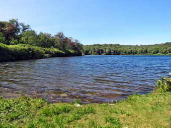
 As we walked the trail toward the woods road, I pointed out to Bryce the large blowdown that Ranger Straton and I had cut. We turned right on the woods road that was once the extension of Beech Mountain Road and we immediately recognized that a large amount of water had come down the trail. The trail was wet and had muddy spots. It is a long climb toward the junction with the Big Rock Trail but it seemed to me we were moving very quickly and I was feeling full of energy. I knew that this was mostly due to the fact that Bryce was with me and we kept up a constant conversation that made the hike easier. At about 1.2 miles we came to the point where I sometimes turn off the trail to visit an interesting clearing. I decided to bypass this area and return in the fall to find some leaf colors. We continued on the main trail toward the trail junction passing a rather large blowdown. We had cut the blowdown back on our last work trip but I would like to cut it back a little more. Our walk to the Big Rock Junction went quickly and we arrived after hiking 1.7 miles. We continued straight ahead on the Flynn Trail to the next trail junction. We stayed to the left to follow the Flynn Trail down to Hodge Pond. As we walked out to the field at the outlet end of Hodge Pond and into the sun, I noticed the apparent increase in temperature. I also noticed there was a breeze which was almost cold! We walked down the rest of the Flynn Trail and out into the field by Hodge Pound. We walked over to the shore and I took a few pictures. The sky was blue and there were nice white clouds to increase the contrast with the rest of the sky. A few of the trees around the pond showed some change in color. The level of the pond was higher than I had ever seen it and the outlet area was flooded! The flooding spread over the Flynn Trail. It appeared that the beavers had blocked the culvert at the outlet end of the pond. I did throw a few sticks for Sheila but she was not enthusiastic about swimming to retrieve them. After a few minutes, we walked back to the Flynn Trail and carefully picked our way through the flooded ground. We followed the Flynn Trail along the west side of the pond.
 The trail was wet and muddy in places and these were not always easily avoided. At the next trail junction we stayed to the left to take the Flynn Trail up the hill rather than the jeep road around the back of the Hodge Pond. The trail up to the gate was relatively dry. The large blowdown that had blocked the trail had been cut and moved off the trail. The rest of the trail was wetter than I had ever seen it and muddy for the entire distance to Junkyard Junction. The walk to the Quick Lake Trail at Junkyard Junction went slowly as we tried to find the best way through the water and the bud. It was 3:40 PM and we had hiked 3.4 miles which is a little more than halfway through the hike. We turned left to start the hike back and although we tried to increase our pace we were slowed by the water and mud on this trail. The conditions were more wet than muddy and a little better than the Flynn Trail as the drainage was better. The trail initially rolls some but eventually descends toward Iron Wheel Junction. We continued to remove large and small branches from the trail. We turned right at Iron Wheel Junction after hiking 5 miles. We stopped for a few moments and I took a few shots of the wheels that give the junction its name. The turn allowed us to stay on the Quick Lake Trail heading for Frick Pond. The trail conditions included both water and mud but we were getting used to this! Every now and then one of us would misjudge a step and sink into the mud. Eventually, we came to and crossed the small stream through the woods with some difficulty as it was rather high. We walked through the spruce tunnel which was almost dry and out the other side. There were a few blowdowns and some were flat on the ground but others would need to be cut before the winter season. After leaving the shelter of the trees, the trail was wet and muddy in most places. We passed by the junction with the Big Rock Trail on the left and were soon at the bridge over the Frick Pond outlet. I dropped my pack and got out the camera. I have taken hundreds of pictures form the bridge but can't resist stopping to take a few more. The water level was high and there was a good volume flowing in the outlet stream. After I took some picture, we walked up the hill from Frick Pond to Gravestone Junction. The memorial stone was still in place and had not been moved. We continued straight ahead on the Quick Lake Trail. The trail was wet for almost the entire way back to the car with muddy places throughout. We passed by the register and walked the woods road back to the parking area. There was still a car in the larger parking area. We were back at the car at 5:25 PM having hiked 6.7 miles in 3 hours and 35 minutes with a vertical gain of 900 feet.
![]()
![]()
![]()
![]() On Tuesday, August 22nd I wanted to get out for a hike after a few days getting reacquainted with my bicycle. I had not ridden in at least 5 years and was afraid I might not remember how or might not enjoy it. I found out that I did remember how to ride and it is exhilarating! I found that I need more leg muscle and a greater aerobic capacity. My grandchildren Luke and Lily were at the house and I offered to take them across the street for a short hike. Lily agreed and we started to get ready at 1:15 PM with the temperature at 78 degrees on the back porch. I decided to wear my White Sierra long-sleeved crew shirt without a baselayer. I wore my Railriders hiking pants which are expensive but last along time and have features like deep pockets and a generous cut which I really like. The pants have Velcro closures at the ankles. I decided to put on my Keen Durand hiking boots which I ordered a half size larger than the previous pair. These shoes fit well out of the box but get much tighter when I add a decent insole. Without the third party insole, my feet hurt from the lack of support. I added a new pair of Xstance insoles in an effort to find the best support and cushioning for my feet. These insoles have shock absorbing gel pads, TPU arch support, and memory foam cushioning all wrapped in a breathable fabric. The insoles have been hyped by their manufacturer and they really do seem to deliver. I decided to take my Leki poles with external locks as the internal twist locks sometimes fail. I did not put on any gaiters although I thought about it due to the numerous ticks which had plagued me on previous hikes. I put my phone in my pocket and grabbed Sheila's leash from my trunk. I gave Lily the leash which she attached to Sheila as we walked up the driveway at 1:30 PM. We walked across the street and to the parking lot of the Presbyterian Church. We started off by walking behind the church to get to the road up the hill to the trailhead. We began the ascent of the steepest hill behind the church. The hill is short but gets the circulation pumping and is the steepest and longest climb on the "trail." Lily and Sheila were setting a fast pace as we climbed the hill and I was having some trouble keeping up. It seemed a little warmer but less humid than some previous hikes. My goal is always to make it all the way up the hill without stopping which I was able to do without much of a problem. We stopped at the top of the hill so that we could take a look around at the scenery.
On Tuesday, August 22nd I wanted to get out for a hike after a few days getting reacquainted with my bicycle. I had not ridden in at least 5 years and was afraid I might not remember how or might not enjoy it. I found out that I did remember how to ride and it is exhilarating! I found that I need more leg muscle and a greater aerobic capacity. My grandchildren Luke and Lily were at the house and I offered to take them across the street for a short hike. Lily agreed and we started to get ready at 1:15 PM with the temperature at 78 degrees on the back porch. I decided to wear my White Sierra long-sleeved crew shirt without a baselayer. I wore my Railriders hiking pants which are expensive but last along time and have features like deep pockets and a generous cut which I really like. The pants have Velcro closures at the ankles. I decided to put on my Keen Durand hiking boots which I ordered a half size larger than the previous pair. These shoes fit well out of the box but get much tighter when I add a decent insole. Without the third party insole, my feet hurt from the lack of support. I added a new pair of Xstance insoles in an effort to find the best support and cushioning for my feet. These insoles have shock absorbing gel pads, TPU arch support, and memory foam cushioning all wrapped in a breathable fabric. The insoles have been hyped by their manufacturer and they really do seem to deliver. I decided to take my Leki poles with external locks as the internal twist locks sometimes fail. I did not put on any gaiters although I thought about it due to the numerous ticks which had plagued me on previous hikes. I put my phone in my pocket and grabbed Sheila's leash from my trunk. I gave Lily the leash which she attached to Sheila as we walked up the driveway at 1:30 PM. We walked across the street and to the parking lot of the Presbyterian Church. We started off by walking behind the church to get to the road up the hill to the trailhead. We began the ascent of the steepest hill behind the church. The hill is short but gets the circulation pumping and is the steepest and longest climb on the "trail." Lily and Sheila were setting a fast pace as we climbed the hill and I was having some trouble keeping up. It seemed a little warmer but less humid than some previous hikes. My goal is always to make it all the way up the hill without stopping which I was able to do without much of a problem. We stopped at the top of the hill so that we could take a look around at the scenery.
At the top of the hill we turned left and entered the woods to begin our hike. We could immediate feel that the temperature had dropped several degrees because of the shade and a slight breeze. The forecast was for rain in the afternoon but the skies remained blue with puffy white clouds. I pointed out to Lily the trees I had recent cut with hand tools to clear the trail. The trail was damp in some places and a little muddy in others. At the first trail junction, we followed Sheila as she continued straight ahead up the hill toward the lookout. The trail was well-worn as this is the most popular part of the hike. Some people simply hike up to the lookout over town and then back down. When we reached the top of the trail, we continued straight ahead passing the path to the lower lookout. I had tried blocking the trail with brush but people kept removing the obstacles. The problem is there is a growing chasm which could be difficult for some people to cross. At least the path is not marked as part of the trail system. We stopped at the upper viewpoint and took in the views down into town including the school. We also got a nice view of the hills surrounding the valley. When we had finished enjoying the view, we walked back to the yellow trail as it headed uphill toward the next trail junction. As we walked up the trail, we removed a few loose branches from the trail. The trail was flanked by ferns with a thin path through them. I knew that soon the ferns would turn brown as fall approaches. We passed the "sitting rock" and continued on the yellow trail to the first junction with the blue trail. At the junction we turned right and walked on the yellow trail along the base of Round Top. I made note that although I had cut back the brush there were still a few branches that were leaning in and needed to be lopped. At the next junction with the blue trail, we turned left and started up toward the summit. We passed the spot where I had cut a large branch that was partly blocking the trail. Everything was very green and there were a few branches encroaching on the trail. We bypassed the white crossover trail and walked over the summit to start down the other side. We again bypassed the white crossover trail but turned left on the switchback in the blue trail. We passed some more branches that I had cut and removed from the trail. The switchback took us out into the woods before turning almost 180 degrees to take us back to the main blue trail. We turned left and walked downhill to the yellow trail where we turned left again. As we walked, Lily and I talked about her horse riding and school subjects. I don't get to talk to Lily very often and found the conversation very enjoyable. We walked along the base of Round Top on the yellow trail. This time when we reached the trail junction we turned right to head down the trail to the woods road. In several places it was clear that a large amount of water had washed over the trail cleaning away the leaves and pine needles. We continued to follow the yellow blazes back to the first trail junction.
I decided we would complete another figure 8 and Lily seemed amenable so we turned around and walked back up the woods road. At the end of the woods road, we followed the yellow trail as the blazes turned up the hill toward the junction with the blue trail. When we reached this junction, we turned left and walked the yellow trail along the base of Round Top. At the next junction, with the blue trail, we turned right and began to walk up the blue trail toward the summit. We continued straight ahead up the hill following what was once the main blue trail. I had unblazed this part of the trail to give it a rest but it seemed it was still popular with people who use the trails. We turned right on the white crossover trail. We walked along the white trail and I removed a few branches from the trail. We contiued out to the main trail and turned right on the blue trail. We started down the hill to the junction with the yellow trail. We turned right and again followed the yellow trail along the base of Round Top. At the next junction with the blue trail, we turned left and continued to follow the yellow trail downhill toward the lookout. We passed the "Sitting Rock" and soon came to the viewpoint. We followed the yellow trail as it turned left and started downhill to the first trail junction. When we reached the first junction, we continued straight ahead to the trailhead where we turned right and walked down the road to the parking lot of the Presbyterian Church. Lily put Sheila back on her leash to cross the street. we walked across Rock Avenue to our driveway. We were back at 2:45 PM after walking about two miles in 1 hour and 15 minutes which included the time needed to do some light trail maintenance. The temperature was now 74 degrees and the skies were still blue with no rain in sight.
![]()
![]()
![]()
![]()
![]() On Sunday, August 27 I wanted to get out for a hike after church. Sunday is a good day to hike as there is ambulance crew on call from 6:0o AM to 6:00 PM. After retuning from church I decided I would go to the Parksville Rail Trail for a quick hike as I wanted to see what the recent rains had done to the volume of the stream. I asked Cindy if she would like to go along and she said "Yes". I think we both felt it would be a good day to hike as the temperature was 74 degrees and the humidity was low with a slight breeze. The skies were blue with some sun and a slight overcast. We started to get ready at 1:00 PM with Sheila keeping a watchful eye on both of us. The Parksville Rail Trail is about 2.5 miles with a beautiful waterfall. This choice would also allow my to respond on an ambulance call but I decided to leave my phone home so I could better enjoy the hike. As I was getting dressed it looked as if Sheila thought we might not hike again! I decided to wear my White Sierra long-sleeved crew shirt without a baselayer. I wore my Railriders hiking pants which are expensive but last along time and have features like deep pockets and a generous cut which I really like. The pants have Velcro closures at the ankles. I decided to put on my new Keen Durand hiking boots which I ordered a half size larger than the previous pair. These shoes fit well out of the box but get much tighter when I add a decent insole. Without the third party insole, by feet hurt from the lack of support. I added a new pair of Xstance insoles in an effort to find the best support and cushioning for my feet. These insoles have shock absorbing gel pads, TPU arch support, and memory foam cushioning all wrapped in a breathable fabric. The insoles have been hyped by their manufacturer and they really do seem to deliver. I decided to take my Leki poles with external locks as the internal twist locks sometimes fail. I did not put on any gaiters even though numerous ticks had plagued us on previous hikes.
On Sunday, August 27 I wanted to get out for a hike after church. Sunday is a good day to hike as there is ambulance crew on call from 6:0o AM to 6:00 PM. After retuning from church I decided I would go to the Parksville Rail Trail for a quick hike as I wanted to see what the recent rains had done to the volume of the stream. I asked Cindy if she would like to go along and she said "Yes". I think we both felt it would be a good day to hike as the temperature was 74 degrees and the humidity was low with a slight breeze. The skies were blue with some sun and a slight overcast. We started to get ready at 1:00 PM with Sheila keeping a watchful eye on both of us. The Parksville Rail Trail is about 2.5 miles with a beautiful waterfall. This choice would also allow my to respond on an ambulance call but I decided to leave my phone home so I could better enjoy the hike. As I was getting dressed it looked as if Sheila thought we might not hike again! I decided to wear my White Sierra long-sleeved crew shirt without a baselayer. I wore my Railriders hiking pants which are expensive but last along time and have features like deep pockets and a generous cut which I really like. The pants have Velcro closures at the ankles. I decided to put on my new Keen Durand hiking boots which I ordered a half size larger than the previous pair. These shoes fit well out of the box but get much tighter when I add a decent insole. Without the third party insole, by feet hurt from the lack of support. I added a new pair of Xstance insoles in an effort to find the best support and cushioning for my feet. These insoles have shock absorbing gel pads, TPU arch support, and memory foam cushioning all wrapped in a breathable fabric. The insoles have been hyped by their manufacturer and they really do seem to deliver. I decided to take my Leki poles with external locks as the internal twist locks sometimes fail. I did not put on any gaiters even though numerous ticks had plagued us on previous hikes.
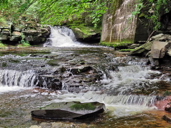 At 1:20 PM I put our gear in the car and Sheila in the back seat and headed out Old Route 17 and drove across the Flats. I took Old Route 17 and Service Road to the point where they meet Fox Mountain Road. There was one pickup truck in the parking lot which was not surprising for such a beautiful day. It seemed a family was getting ready to hike so I put Sheila on her leash and we departed the parking area t 1:35 PM with the temperature at 74 degrees. The open trail just before the woods was barely damp but showed some erosion from the downpours that had occurred lately. I checked the bushes that I had cut back and they remained well off the trail. I released Sheila from her leash and we moved on toward the wooded part of the trail. We immediately ran into some mud pits with some water but less than on our last trip. One look down to the Little Beaverkill showed the stream volume was lower than our last visit but there was still a good volume of water. I wondered about the condition of the falls and whether they would be as interesting as my last trip. Sheila was taking her own route and following her nose and getting very close to the edge of the trail where a steep drop led down to the river! We began to run into some branches hanging into the trail from the side and above. There was one new trunk hanging across the trail which I knew I could cut with a saw. I did pick up some newly fallen branches and throw them off the trail. I continued to do this for the rest of the hike as the winds from the storms had loosened branches that had then fallen on the trail. We crossed several muddy areas and were soon at the wooden walkways. I decided to take some pictures of the stream and sky. When I was done, we continued over the wooden walkways and bridges which were wet and muddy from the rain. I thought about bringing a rake and a broom next time to clean off the bridges which were covered in a mixture of wet leaves and mud. This time the water from the small stream was actually flowing through the culvert under the bridge or around the edge and not onto the bridge. After crossing the bridge, we ran into another large mud pit that had a layer of water with a few stepping stones. There continued to be small branches to remove as we walked. We continued at a moderate pace as it made my foot feel better.
 At one point I looked up and a couple coming toward us with a small dog. I decided to put Sheila on her leash but when I reached into my pocket it was not there. I left Cindy and Sheila at a bench and turned around to head back toward the trailhead to look for the leash. I set a quick pace and soon met the family headed toward me. The parents had four young children and all but the baby were walking. As we neared each other, the young father spoke to me and I recognized him as a New York State Trooper and a Roscoe fireman. I asked if they had seen a leash and they said it was near the beginning of the trail. I quickened my pace but kept expecting to see the leash! Eventually, at the point where I let Sheila off her leash, I found it lying on the trail. I retrieved the leash and started back to Cindy. Along the way I met the couple with the dog and another older couple. It was nice to see people using the trail. I crossed the bridge and reunited with Cindy and Sheila at the bench. As we approached the falls, we could hear a loud sound which was the falls. We arrived at the falls and found that there was a nice flow of water but the volume was lower than the highest we had seen. The water was very clear as it flowed over the falls to the basin below. I decided to go down to the streambed to take pictures even though I have quite a few pictures from the base of the falls. I left my poles at the picnic table and Sheila and I head down the bank to the stream. I put my pack down by the stream and took out my camera. I took some shots downstream and then turned my attention to the falls. I took some shots of the upper falls and lower rapids. After the wide-angle pictures, I took some close-ups of both falls. When I finished, we climbed back up the bank. I took some shots of the falls from above from different locations and different angles. I also took picture upstream from this higher angle. I could see that the path along the edge of the stream was almost dry but I decided not to try my luck over the slippery rocks. We moved on down the trail and stopped at the next bench. I walked a short way down the path and took a few shots upstream of the rapids. When done, we started toward the Parksville end of the trail. We met another couple walking toward us and we said "Hello". We continued walking toward Parksville with Cindy and I walking together for a change which I found very enjoyable. Along the way we ran into some loud music and an even louder dog. The dog was on the other shore of the stream and really looked and sounded like he wanted to join us. We continued on to the end of the trail meeting another young man hiking the trail. We turned around at the sign detailing the hotels in Parksville. We met the couple with the dog which turned out to be a Shiba Inu and very well-behaved. Eventually we came to the falls where the young family was eating at the picnic table. We continued at a respectable pace back toward the parking area. A woman came up behind us and we moved over to let her pass but she did not and slowed as we continued to hike. We arrived at the car at 3:15 PM after hiking about 3.0 miles in 1 hour and 40 minutes. There is virtually no elevation gain on the hike but carrying a pack helps with the exercise.
![]()
![]()
![]()
![]() On Tuesday, August 22nd I wanted to get out for a hike after a few days hiatus. The number of ambulance calls our corps had been covering had been sky-rocketing and that had been limiting my time for hiking. Lisa contacted me and suggested going for a hike and O suggested Round Top. From Round Top I could cover ambulance calls if no one else was available. We agreed on a 9:00 AM start but and an ambulance call postponed the time t0 11:00 AM. I returned from the call and started getting ready at 10:30 AM. The temperature was 72 degrees on the back porch so I decided to wear my White Sierra long-sleeved crew shirt without a baselayer. I wore my Railriders hiking pants which are expensive but last along time and have features like deep pockets and a generous cut which I really like. The pants have Velcro closures at the ankles. I decided to put on my new Keen Durand hiking boots which I ordered a half size larger than the previous pair. These shoes fit well out of the box but get much tighter when I add a decent insole. Without the third party insole, my feet hurt from the lack of support. I added a new pair of Xstance insoles in an effort to find the best support and cushioning for my feet. These insoles have shock absorbing gel pads, TPU arch support, and memory foam cushioning all wrapped in a breathable fabric. The insoles have been hyped by their manufacturer and they really do seem to deliver. I decided to take my Leki poles with external locks as the internal twist locks sometimes fail. I did not put on any gaiters although I thought about it due to the numerous ticks which had plagued me on previous hikes. I did wear my OR wide brimmed hat. I put my phone in my pocket and grabbed Sheila's leash from my trunk as we walked up the driveway at 10:55 AM. We walked across the street and to the parking lot of the Presbyterian Church where Lisa was waiting. As soon as Sheila saw Lisa she started pulling on the leash. Sheila gave Lisa an extended hello and then settled down. We started off by walking behind the church to get to the road up the hill to the trailhead. We began the ascent of the steepest hill behind the church. The hill is short but gets the circulation pumping and is the steepest and longest climb on the "trail." We were setting a relatively fast pace as we climbed the hill. It seemed a little cooler and less humid than some previous hikes and the poles really helped. My goal is always to make it all the way up the hill without stopping which I was able to do without much of a problem. We stopped at the top of the hill so that we could take a look around at the scenery.
On Tuesday, August 22nd I wanted to get out for a hike after a few days hiatus. The number of ambulance calls our corps had been covering had been sky-rocketing and that had been limiting my time for hiking. Lisa contacted me and suggested going for a hike and O suggested Round Top. From Round Top I could cover ambulance calls if no one else was available. We agreed on a 9:00 AM start but and an ambulance call postponed the time t0 11:00 AM. I returned from the call and started getting ready at 10:30 AM. The temperature was 72 degrees on the back porch so I decided to wear my White Sierra long-sleeved crew shirt without a baselayer. I wore my Railriders hiking pants which are expensive but last along time and have features like deep pockets and a generous cut which I really like. The pants have Velcro closures at the ankles. I decided to put on my new Keen Durand hiking boots which I ordered a half size larger than the previous pair. These shoes fit well out of the box but get much tighter when I add a decent insole. Without the third party insole, my feet hurt from the lack of support. I added a new pair of Xstance insoles in an effort to find the best support and cushioning for my feet. These insoles have shock absorbing gel pads, TPU arch support, and memory foam cushioning all wrapped in a breathable fabric. The insoles have been hyped by their manufacturer and they really do seem to deliver. I decided to take my Leki poles with external locks as the internal twist locks sometimes fail. I did not put on any gaiters although I thought about it due to the numerous ticks which had plagued me on previous hikes. I did wear my OR wide brimmed hat. I put my phone in my pocket and grabbed Sheila's leash from my trunk as we walked up the driveway at 10:55 AM. We walked across the street and to the parking lot of the Presbyterian Church where Lisa was waiting. As soon as Sheila saw Lisa she started pulling on the leash. Sheila gave Lisa an extended hello and then settled down. We started off by walking behind the church to get to the road up the hill to the trailhead. We began the ascent of the steepest hill behind the church. The hill is short but gets the circulation pumping and is the steepest and longest climb on the "trail." We were setting a relatively fast pace as we climbed the hill. It seemed a little cooler and less humid than some previous hikes and the poles really helped. My goal is always to make it all the way up the hill without stopping which I was able to do without much of a problem. We stopped at the top of the hill so that we could take a look around at the scenery.

![]()
![]()
![]()
![]()
![]() On Thursday, August 18 I wanted to get out for a hike but had to try to plan around the numerous ambulance calls we had been getting. I finally decided I would go to the Parksville Rail Trail and trim some of the bushes and branches hanging into the trail. Cindy and granddaughter Ariana were going to Hunter Lake so Sheila and I would be on our own. I started to get ready at 2:20 PM with Sheila keeping a watchful eye on me. One look outside showed a blue skies and many puffy white clouds in one direction and swirling darker clouds in the other. The Parksville Rail Trail which is about 2.5 miles with a beautiful waterfall. This choice would also allow me to respond to an ambulance call even if I was a little delayed. We had been hiking more regularly since April but as I was getting dressed it looked as if Sheila thought we might not hike again! I decided to wear my White Sierra long-sleeved crew shirt without a baselayer. I wore my Railriders hiking pants which are expensive but last along time and have features like deep pockets and a generous cut which I really like. The pants have Velcro closures at the ankles. I decided to put on my new Keen Durand hiking boots which I ordered a half size larger than the previous pair. These shoes fit well out of the box but get much tighter when I add a decent insole. Without the third party insole, by feet hurt from the lack of support. I added a new pair of Xstance insoles in an effort to find the best support and cushioning for my feet. These insoles have shock absorbing gel pads, TPU arch support, and memory foam cushioning all wrapped in a breathable fabric. The insoles have been hyped by their manufacturer and they really do seem to deliver. I decided to take my Leki poles with external locks as the internal twist locks sometimes fail. I did not put on any gaiters even though we had encountered numerous ticks on previous hikes. I put my Corona loppers, Silky Sugowaza saw and LTW Overland machete in the car.
On Thursday, August 18 I wanted to get out for a hike but had to try to plan around the numerous ambulance calls we had been getting. I finally decided I would go to the Parksville Rail Trail and trim some of the bushes and branches hanging into the trail. Cindy and granddaughter Ariana were going to Hunter Lake so Sheila and I would be on our own. I started to get ready at 2:20 PM with Sheila keeping a watchful eye on me. One look outside showed a blue skies and many puffy white clouds in one direction and swirling darker clouds in the other. The Parksville Rail Trail which is about 2.5 miles with a beautiful waterfall. This choice would also allow me to respond to an ambulance call even if I was a little delayed. We had been hiking more regularly since April but as I was getting dressed it looked as if Sheila thought we might not hike again! I decided to wear my White Sierra long-sleeved crew shirt without a baselayer. I wore my Railriders hiking pants which are expensive but last along time and have features like deep pockets and a generous cut which I really like. The pants have Velcro closures at the ankles. I decided to put on my new Keen Durand hiking boots which I ordered a half size larger than the previous pair. These shoes fit well out of the box but get much tighter when I add a decent insole. Without the third party insole, by feet hurt from the lack of support. I added a new pair of Xstance insoles in an effort to find the best support and cushioning for my feet. These insoles have shock absorbing gel pads, TPU arch support, and memory foam cushioning all wrapped in a breathable fabric. The insoles have been hyped by their manufacturer and they really do seem to deliver. I decided to take my Leki poles with external locks as the internal twist locks sometimes fail. I did not put on any gaiters even though we had encountered numerous ticks on previous hikes. I put my Corona loppers, Silky Sugowaza saw and LTW Overland machete in the car.
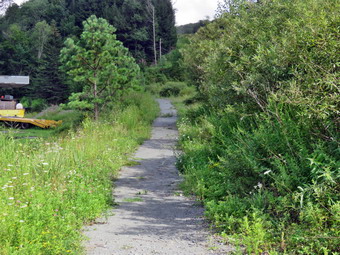 At 2:45 PM I put our gear in the car and Sheila in the back seat and headed out Old Route 17 and drove across the Flats. I took Old Route 17 and Service Road to the point where they meet Fox Mountain Road. There was no cars in the parking lot which was surprising for such a beautiful day. We started out on the trail at 3:00 PM with the temperature at 80 degrees under variable skies with a slight breeze blowing. I had decided to trim the bushes along the start of the trail before going any further. I took some pictures of the trail which in places was narrowed by half. I then got out my machete and took a couple of swings at the brush. It was woodier and a little more robust than I thought so I switched to the loppers. These Corona loppers are by pass loppers with extensible handles. They work best on branches of larger diameters. I cut the first stand of brush throwing the cut pieces into a pile in the middle of the trail. I always make sure to pile the brush with the cut ends all in the same place. This makes it easier to pick up most of the pile in one shot and move it to the side of the trail. After finishing the first set of bushes, I moved on to the second set which were much larger in diameter. It seemed to take a long time but I was finally done. I decided to move the two piles I had created to the side of the trail. I moved all the branches and created a nice pile of brush. These piles act as shelter for rabbits and other animals.
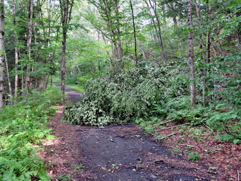 I moved on to the third and fourth set of bushes and gave them the same treatment as the first two. I tend to cut a little more than is needed because I know how fast the brush grows back. When I was done cutting, I moved the brush off the trail forming a second pile. When I looked at my watch, I was surprised it was only 3:35 PM! I took some pictures of the trail after I had done the work and then we walked back to the car. I decided we would try to take a quick walk to the falls even though the skies were string to get darker. I stowed the loppers in the car but took the machete with me in my pack. We started back out on the trail and a quick pace. As we entered the woods, we immediately ran into some mud pits with quite a bit of water. One look down to the Little Beaverkill showed the stream volume was higher than our last visit. I wondered about the condition of the falls and whether they would be as interesting as my last trip. Sheila was taking her own route and following her nose and getting very close to the edge of the trail where a steep drop led down to the river! We began to run into some branches hanging into the trail from the side and above but I ignored them. We didn't get very far before we came to a food sized tree that had fallen across the trail. One looked convinced me I could cut it with the saw that was in the car. Once again we turned around and quick hiked back to the car. I exchanged the machete for the saw and we hiked back to the fallen tree.
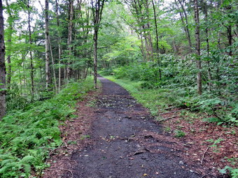 I took some pictures of the tree and then grabbed the saw. I always use the same method to cut these trees. I began to cut off smaller branches and throw them well off the trail. Soon there were only a few larger branches left. I cut one and threw it off the trail and repeated the process until only the main trunk was left. I cut this well off the trail and three it down the bank. I took some "after" pictures and then we continued on the trail. We continued to run into wet and muddy spots but made it through without a problem. There was another small tree laying parallel to the trail and I used the saw to cut it into pieces and moved them away from the trail. I noticed that the skies seemed to be getting darker as we arrived at the wooden walkway. Even though the sky was now overcast, I took some pictures of the skies and some down to the stream. I took a couple of shots of the walkways and then we walked over them. The end of the walkway toward Parksville is a mess as it is covered by mud and gravel. The culvert under the bridge is blocked and all the water and what the water is carrying flows over the bridge and the walkway. This leaves a slippery and dangerous mess behind. At this point I had to make a decision whether or not to go to the falls. I decided to turn around and walk quickly back to the car before the rail hit. We set a fast pace and did not stop. As we broke out of the trees, the skies were blue and sunny with beautiful puffy white clouds! We walked back to the car where Sheila jumped into the back seat. I stowed by gear and noted that the time was 4:35 PM. We had not hiked as far as I would have liked but I did get some work done that I had wanted to do for some time.
![]()
![]()
![]()
![]() On Wednesday, August 16th I wanted to get out for a hike after a few days hiatus. The number of ambulance calls our corps had been covering had been sky-rocketing and that had been limiting my time for hiking. In July we responded to 99 calls! I needed to get out for some exercise and relazation. By granddaughter Ariana was visiting so I decided we could go across the street and hike on Round Top. From Round Top I could cover ambulance and could also abort the hike easily if my foot began to bother me. The temperature was 74 degrees on the back porch so I decided to wear my White Sierra long-sleeved crew shirt without a baselayer. I wore my Railriders hiking pants which are expensive but last along time and have features like deep pockets and a generous cut which I really like. The pants have Velcro closures at the ankles. I decided to put on my new Keen Durand hiking boots which I ordered a half size larger than the previous pair. These shoes fit well out of the box but get much tighter when I add a decent insole. Without the third party insole, my feet hurt from the lack of support. I added a new pair of Xstance insoles in an effort to find the best support and cushioning for my feet. These insoles have shock absorbing gel pads, TPU arch support, and memory foam cushioning all wrapped in a breathable fabric. The insoles have been hyped by their manufacturer and they really do seem to deliver. I decided to take my Leki poles with external locks as the internal twist locks sometimes fail. I did not put on any gaiters although I thought about it due to the numerous ticks which had plagued me on previous hikes. I put my phone in my pocket and grabbed Sheila's leash from my trunk as we walked up the driveway at 2:15 PM. We walked across the street and to the parking lot of the Presbyterian Church. We walked behind the church to get to the road up the hill to the trailhead. I gave Ariana Sheila's leash so that I could use my poles. We began the ascent of the steepest hill behind the church. The hill is short but gets the circulation pumping and is the steepest and longest climb on the "trail." Ariana and Sheila were setting a quick pace as they effortlessly climbed the hill. It seemed a little cooler and less humid than some previous hikes and the poles really helped. My goal is always to make it all the way up the hill without stopping which I was able to do without much of a problem. We stopped at the top of the hill so that I could point out some landmarks like Beer Mountain to Ariana. We also discussed the fact that hillside creep is causing some of the grave markers to fall over
On Wednesday, August 16th I wanted to get out for a hike after a few days hiatus. The number of ambulance calls our corps had been covering had been sky-rocketing and that had been limiting my time for hiking. In July we responded to 99 calls! I needed to get out for some exercise and relazation. By granddaughter Ariana was visiting so I decided we could go across the street and hike on Round Top. From Round Top I could cover ambulance and could also abort the hike easily if my foot began to bother me. The temperature was 74 degrees on the back porch so I decided to wear my White Sierra long-sleeved crew shirt without a baselayer. I wore my Railriders hiking pants which are expensive but last along time and have features like deep pockets and a generous cut which I really like. The pants have Velcro closures at the ankles. I decided to put on my new Keen Durand hiking boots which I ordered a half size larger than the previous pair. These shoes fit well out of the box but get much tighter when I add a decent insole. Without the third party insole, my feet hurt from the lack of support. I added a new pair of Xstance insoles in an effort to find the best support and cushioning for my feet. These insoles have shock absorbing gel pads, TPU arch support, and memory foam cushioning all wrapped in a breathable fabric. The insoles have been hyped by their manufacturer and they really do seem to deliver. I decided to take my Leki poles with external locks as the internal twist locks sometimes fail. I did not put on any gaiters although I thought about it due to the numerous ticks which had plagued me on previous hikes. I put my phone in my pocket and grabbed Sheila's leash from my trunk as we walked up the driveway at 2:15 PM. We walked across the street and to the parking lot of the Presbyterian Church. We walked behind the church to get to the road up the hill to the trailhead. I gave Ariana Sheila's leash so that I could use my poles. We began the ascent of the steepest hill behind the church. The hill is short but gets the circulation pumping and is the steepest and longest climb on the "trail." Ariana and Sheila were setting a quick pace as they effortlessly climbed the hill. It seemed a little cooler and less humid than some previous hikes and the poles really helped. My goal is always to make it all the way up the hill without stopping which I was able to do without much of a problem. We stopped at the top of the hill so that I could point out some landmarks like Beer Mountain to Ariana. We also discussed the fact that hillside creep is causing some of the grave markers to fall over
On Friday, August 11th I wanted to get out for a hike after almost a week of ambulance calls, poor weather and church commitments. My foot pain was still bothering me but I had grown used to it. I had been resting it and stretching my lower legs and hiking every few days. Fortunately, my routine seemed to be working. The number of ambulance calls our corps had been covering had been sky-rocketing and that had been limiting my time for hiking. I awoke at 9:00 AM after covering a late night call. I decided I would go to church and do some work to gee the Sunday service ready. I left the house at 10:30 AM and headed for the church which is north of Roscoe. I got my work done and then headed home. I had taken my pager and phone but neither indicated any ambulance calls. I was home just after noon and ate some lunch. The house was empty as everyone else had gone swimming at the lake. I took nap and by 3:00 PM was ready to get some work done clearing the trails on Round Top. I could cover ambulance from there and I could abort the hike easily if my foot began to bother me. The temperature was 80 degrees on the back porch so I decided to wear my White Sierra long-sleeved crew shirt without a baselayer. I wore my Railriders hiking pants which are expensive but last along time and have features like deep pockets and a generous cut which I really like. The pants have Velcro closures at the ankles. I decided to put on my new Keen Durand hiking boots which I ordered a half size larger than the previous pair. These shoes fit well out of the box but get much tighter when I add a decent insole. Without the third party insole, my feet hurt from the lack of support. I added a new pair of Xstance insoles in an effort to find the best support and cushioning for my feet. These insoles have shock absorbing gel pads, TPU arch support, and memory foam cushioning all wrapped in a breathable fabric. The insoles have been hyped by their manufacturer and they really do seem to deliver. I did not put on any gaiters although I thought about it due to the numerous ticks which had plagued me on previous hikes. I put my phone in my pocket and loaded my tools into the trunk of my car. I took my Fiskars pack axe, Sugowaza saw, Corona loppers and LTW Overland machete. We walked across the street and to the parking lot of the Presbyterian Church. We walked behind the church to get to the road up the hill to the trailhead. After putting Sheila in the back seat, I drove out the driveway and up Orchard Street into the cemetery. I drove to the trailhead at the highest point in the cemetery and parked on the side of the road. I don't take the care very often as the trailhead is so close to my house but I had my tools to transport.
I grabbed my Fiskars and started out on the trail with Sheila in tow. We came to a small tree that had fallen parallel to the trail and projected out into the trail bed. I sized up the situation and decided to make two cuts which would enable me to lift and roll the sections off the trail. I used the ax to cut off the top section which went faster than I expected. I was easily able to pivot the top section off terrain before turning my attentions to the next cut. I started a cut which would divide the remaining trunk in half. This cut went almost as fast as the first. I rolled the lower section off the trail and then lifted and flipped the middle section so that it was out of the way. I looked at my watch and realized it had taken less then 10 minutes to do the job. I walked back to the car and stowed the ax as I knew I would not need it again. I picked up the machete and saw, locked the car, and head back out on the trail. At the first trail junction we turned right and headed up the woods road. I picked up a few branches along the way but there was nothing to trim. We turned left off the woods road and followed the trail up the hill toward the next trail junction. On the way up the trail I stopped to use the machete to cut back some brush although nothing was too bad. At the trail junction with the blue trail we continued straight ahead an immediately came to a large branch hanging into the trail. I grabbed the saw, cut the branch, and dragged it off the trail. For the rest of the trail to the summit I cut brush on both sides of the trail using primarily the machete. I have used this machete many times and can only remember sharpening it once but it remains very sharp. I tend to cut the trails a little wider and higher than might seem necessary. I cut them wider because the remaining brush will eventually fall into the trail. I cut them higher so that people can snowshoe without encountering branches in their face. Once at the top of the trail we turned right and then left continuing to cut brush and move it off the trail. On the summit I used the saw to cut a few small trees and then we started down the blue trail on the other side. I cut some brush and then we turned left on the switchback. We stopped at some trees than had fallen and were encroaching on the trail. I used the saw to cut up the trees and removed the sections from the trail. I cut another small tree off the trail and one that was hanging over the trail. We made the sharp right turn and walked out to the main trail without finding any obstructions. We turned left and walked downhill toward the junction with the yellow trail. I cut one tree out of the trail on the way down. At the junction we turned left on the yellow trail and I immediately began to trim weeds and brush back from the trail with the machete. At one point, there were several bushes leaning into the trail and I decided to remove the lot. I used the saw to cut the brush and then I dragged it of the trail. This took a little linger than I expected as there was more brush than I expected. When we were done, we continued on the trail and I cut a little more brush out to the next junction with the blue trail. We did meet one man walking toward us and I said "Hello" as we passed. At the junction with the blue trail we turned right and walked down the yellow trail to the woods road. As we walked I admired the work I had done. We turned right on the woods road and walked downhill to the first trail junction. It was well after 5:00 PM when we turned left and headed out to the trailhead. I put the tools in the car and Sheila jumped into the back seat. As I drove down the hill we met another man walking up the hill. At the bottom of the hill was group of six young people who appeared to be starting up the hill. I drove home and noted it was 5:30 PM. I had spent 2 hours walking and working and was very satisfied with the job I had done.
![]()
![]()
![]()
![]() On Saturday, August 6th I wanted to get out for a hike after a few days hiatus. I had been nursing a painful right foot by resting it and stretching my lower legs and hiking every few days. Fortunately, my routine seemed to be working. The number of ambulance calls our corps had been covering had been sky-rocketing and that had been limiting my time for hiking. On Saturday I had already covered tnree calls by noon but decided I needed to get out for some exercise. I decided to go across the street and hike on Round Top as I could cover ambulance from there and I could abort the hike easily if my foot began to bother me. The temperature was 74 degrees on the back porch so I decided to wear my White Sierra long-sleeved crew shirt without a baselayer. I wore my Railriders hiking pants which are expensive but last along time and have features like deep pockets and a generous cut which I really like. The pants have Velcro closures at the ankles. I decided to put on my new Keen Durand hiking boots which I ordered a half size larger than the previous pair. These shoes fit well out of the box but get much tighter when I add a decent insole. Without the third party insole, my feet hurt from the lack of support. I added a new pair of Xstance insoles in an effort to find the best support and cushioning for my feet. These insoles have shock absorbing gel pads, TPU arch support, and memory foam cushioning all wrapped in a breathable fabric. The insoles have been hyped by their manufacturer and they really do seem to deliver. I decided to take my Leki poles with external locks as the internal twist locks sometimes fail. I did not put on any gaiters although I thought about it due to the numerous ticks which had plagued me on previous hikes. I put my phone in my pocket and grabbed Sheila's leash from my trunk as we walked up the driveway at 1:45 PM. We walked across the street and to the parking lot of the Presbyterian Church. We walked behind the church to get to the road up the hill to the trailhead. We began the ascent of the steepest hill behind the church. The hill is short but gets the circulation pumping and is the steepest and longest climb on the "trail." It seemed a little cooler and less humid than some previous hikes and Sheila was giving me some help as she pulled on her leash. My goal is always to make it all the way up the hill without stopping which I was able to do without much of a problem.
On Saturday, August 6th I wanted to get out for a hike after a few days hiatus. I had been nursing a painful right foot by resting it and stretching my lower legs and hiking every few days. Fortunately, my routine seemed to be working. The number of ambulance calls our corps had been covering had been sky-rocketing and that had been limiting my time for hiking. On Saturday I had already covered tnree calls by noon but decided I needed to get out for some exercise. I decided to go across the street and hike on Round Top as I could cover ambulance from there and I could abort the hike easily if my foot began to bother me. The temperature was 74 degrees on the back porch so I decided to wear my White Sierra long-sleeved crew shirt without a baselayer. I wore my Railriders hiking pants which are expensive but last along time and have features like deep pockets and a generous cut which I really like. The pants have Velcro closures at the ankles. I decided to put on my new Keen Durand hiking boots which I ordered a half size larger than the previous pair. These shoes fit well out of the box but get much tighter when I add a decent insole. Without the third party insole, my feet hurt from the lack of support. I added a new pair of Xstance insoles in an effort to find the best support and cushioning for my feet. These insoles have shock absorbing gel pads, TPU arch support, and memory foam cushioning all wrapped in a breathable fabric. The insoles have been hyped by their manufacturer and they really do seem to deliver. I decided to take my Leki poles with external locks as the internal twist locks sometimes fail. I did not put on any gaiters although I thought about it due to the numerous ticks which had plagued me on previous hikes. I put my phone in my pocket and grabbed Sheila's leash from my trunk as we walked up the driveway at 1:45 PM. We walked across the street and to the parking lot of the Presbyterian Church. We walked behind the church to get to the road up the hill to the trailhead. We began the ascent of the steepest hill behind the church. The hill is short but gets the circulation pumping and is the steepest and longest climb on the "trail." It seemed a little cooler and less humid than some previous hikes and Sheila was giving me some help as she pulled on her leash. My goal is always to make it all the way up the hill without stopping which I was able to do without much of a problem.
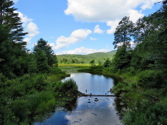
![]()
![]()
![]()
![]()
![]() On Wednesday, August 2nd, I had planned to do some longer hike as the weekend had been filled with ambulance calls and church commitments. At about 11:30 PM the ambulance pager sounded and we responded to a call in another district as there was no other rig available. I came home and was able to get some extra hours of sleep. I got up at 10:00 AM and took care of some things that needed to be done. By 1:00 PM I was ready to go and asked Cindy if she would like to hike the Logger's Loop at Frick Pond and she agreed. This hike is less than 4 miles and is relatively flat. I had not been on the trail for some time and I wanted to see how it had faired after some recent wind and rain storms. We started to get ready with the temperature at 75 degrees on the back porch. As I was getting dressed, Sheila was very quiet but did not let me out of her sight. I decided to put on my long-sleeved White Sierra shirt without a baselayer. I wore my Railriders hiking pants which are expensive but last along time and have features like deep pockets and a generous cut which I really like. The pants have Velcro closures at the ankles. I decided to put on my Keen Durand hiking boots which fit well and are newer than what I have been wearing. I added a new pair of Xstance insoles in an effort to find the best support and cushioning for my feet. These insoles have shock absorbing gel pads, TPU arch support, and memory foam cushioning all wrapped in a breathable fabric. The insoles have been hyped by their manufacturer and I wondered if they would live up to that hype. I grabbed a pair of Leki external lock poles I have been using for some time. I wore my OR brimmed hat as it acts as a base for insect repellant. I did bring along my Silky Sugowaza saw just in case there were a few branches to cut. I put our gear in the car and Sheila in the back seat and we left Livingston Manor at 1:15 PM. I drove out the DeBruce Road about 6 miles to Mongaup Road. I turned left to continue up the road to the point where it splits. I stayed left on Beech Mountain Road and drove to the Frick Pond trailhead. When we arrived at the parking areas, there were no cars parked in either lot. I pulled into the smaller lot and parked. The skies were sunny and blue with a few clouds and a slight breeze blowing. The temperature was right at 72 degrees which was about what I thought it might be. I found I had forgotten my OR gaiters and hoped the numerous ticks that had plagued us on previous hike would not be a problem. I decided that the insects did not seem to be a problem so I did not apply and repellant. We started out the woods road to the register at 1:30 PM. As we walked out the woods road, I cleared some branches and one small trunk from the very damp trail. At the register we continued straight ahead on the Quick Lake Trail. From the register the trail was wet with some standing water and muddy areas.
On Wednesday, August 2nd, I had planned to do some longer hike as the weekend had been filled with ambulance calls and church commitments. At about 11:30 PM the ambulance pager sounded and we responded to a call in another district as there was no other rig available. I came home and was able to get some extra hours of sleep. I got up at 10:00 AM and took care of some things that needed to be done. By 1:00 PM I was ready to go and asked Cindy if she would like to hike the Logger's Loop at Frick Pond and she agreed. This hike is less than 4 miles and is relatively flat. I had not been on the trail for some time and I wanted to see how it had faired after some recent wind and rain storms. We started to get ready with the temperature at 75 degrees on the back porch. As I was getting dressed, Sheila was very quiet but did not let me out of her sight. I decided to put on my long-sleeved White Sierra shirt without a baselayer. I wore my Railriders hiking pants which are expensive but last along time and have features like deep pockets and a generous cut which I really like. The pants have Velcro closures at the ankles. I decided to put on my Keen Durand hiking boots which fit well and are newer than what I have been wearing. I added a new pair of Xstance insoles in an effort to find the best support and cushioning for my feet. These insoles have shock absorbing gel pads, TPU arch support, and memory foam cushioning all wrapped in a breathable fabric. The insoles have been hyped by their manufacturer and I wondered if they would live up to that hype. I grabbed a pair of Leki external lock poles I have been using for some time. I wore my OR brimmed hat as it acts as a base for insect repellant. I did bring along my Silky Sugowaza saw just in case there were a few branches to cut. I put our gear in the car and Sheila in the back seat and we left Livingston Manor at 1:15 PM. I drove out the DeBruce Road about 6 miles to Mongaup Road. I turned left to continue up the road to the point where it splits. I stayed left on Beech Mountain Road and drove to the Frick Pond trailhead. When we arrived at the parking areas, there were no cars parked in either lot. I pulled into the smaller lot and parked. The skies were sunny and blue with a few clouds and a slight breeze blowing. The temperature was right at 72 degrees which was about what I thought it might be. I found I had forgotten my OR gaiters and hoped the numerous ticks that had plagued us on previous hike would not be a problem. I decided that the insects did not seem to be a problem so I did not apply and repellant. We started out the woods road to the register at 1:30 PM. As we walked out the woods road, I cleared some branches and one small trunk from the very damp trail. At the register we continued straight ahead on the Quick Lake Trail. From the register the trail was wet with some standing water and muddy areas.
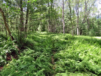 On the way to Gravestone Junction, I cut several branches that were hanging over into the trail. I also pulled down a larger branch that was hungup on anorther. At Gravestone Junction we stayed left on the Quick Lake Trail heading toward the bridge at the outlet to Frick Pond. This area of the trail had more mud but it was minimal compared to what it usually looks like. There were several large branches hanging down into the trail. I got out my saw and cut three or four of them to clear the trail. We continue on the trail and soon arrived at the bridge. I looked at the scene and decided to take some shots even though I have hundreds from the same location. The pond was higher than it had been for some time! I took pictures of the whole scene and some of Beech Mountain. We continued around the west side of the pond where the trail was just damp with a small amount of mud here and there. Even the mud pit was manageable due to the work we had done to increase its drainage. At the junction with the Big Rock Trail, we headed left on the Quick Lake Trail which was almost wet and muddy in places. I had been removing smaller branches but there were a few larger ones in this area that I managed to drag off the trail. There were a few others that I cut. A little farther along there was a good sized trunk across the trail. I got out the saw and made two cuts which allowed me to pivot the cut section off the trail. As we walked through the spruce tunnel, we came upon a rather large blowdown across the trail. Fortunately, I had trimmed most of the branches off it making it easier to get over the large diameter trunk. There were a few more blowdowns that would require a chainsaw. When we came to the small stream across the trail, we found the level high but not so high that we could not cross. Sheila immediately jumped in the water and waded around. I took some pictures before we moved on. We continued on up the Quick Lake Trail toward Iron Wheel Junction. Just after the stream was a new but small trunk across the trail. I decided that I should take a few shots of at least one blowdown so I took some "before shots. I made a cut on one side of the trail and then a cut on the other. The cuts went relatively fast after which I was able to flip the section I cut off the trail. I took some after shots and we continued. Only a few steps up the trail was another larger blowdown. This tree could be cleared with and hand tools but I knew that the local ranger would come and use a chainsaw which would make the job much easier. After the blowdown, the trail was wet and muddy in spots but not as bad as it can be. We cleared one more trunk across the trail before arriving at the trail junction.
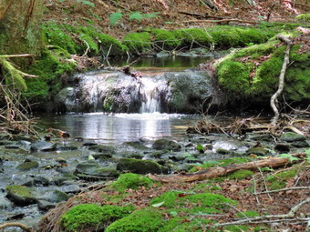 When we got to Iron Wheel Junction, we turned right on the Logger's Loop and started out toward Times Square. We began to notice that the number of insect, particularly mosquitoes, was increasing dramatically. Cindy put in some repellant but I kept moving. The trail seemed to have more water including some shallow puddles. Fortunately, it was pretty easy to get around all of wet and muddy areas. A little farther along there was another large trunk that had fallen across the trail but now lay in pieces. The snowmobile club must have been by to get this one out of the way. There had been a few other trunks lying on the ground that were now gone also. The streams that run across the trail or under it were dry. We passed a tricycle perched on a large rock that had been there for a very long time. The most amazing part of this is that it had been there for 20 years and no one had removed it! We came to the large cherry tree that had broken off high up and fallen so that it was arching across the trail. This tree had also been cleared which I knew would have been a difficult job. We passed the seasonal pond on the left side of the trail and I could see that it was mostly dry. I thought about stopping to take some shots but the gathering cloud of insects discouraged me. We continued downhill to Times Square which was damp. I thought about turning left and climbing the Big Rock Trail to add mileage but I knew Cindy would not be impressed. We walked straight across Times Square to stay on the Logger's Loop and started uphill. Just before the beginning of the uphill was another streambed which we crossed and it was dry. Although the trail is slightly uphill we were setting a good pace. We passed by another medium sized trunk which had been across the trail until we had removed it on one trip. We continued walking on the trail and crested the hill. There was a small blowdown across the teal and I chose to remove it despite the insects. Two quick cut allowed me to lift the setion and throw it off the trail. We continued to walk out to Gravestone Junction where we turned left. We headed back to the car on the woods road. My feet were bothering me and the highly eroded trail was not kind to them. At the register we continued straight ahead on the woods road back to the car. There was one car parked next to ours in the lot. It was 4:15 PM and we had spent 2 hours and 45 minutes hiking 3.7 miles with an elevation gain was a modest 375 feet. Much of this time was spent taking pictures and clearing the trail. The temperature was still 72 degrees as we left the parking area.
![]()
![]()
![]()
![]()
![]() On Monday, July 31st I wanted to get out for a hike but had to try to plan around the numerous ambulance calls we had been getting. I finally decided I would go to the Parksville Rail Trail for a quick hike despite the pain that persisted in my right heel. I have been working on strteching my lower legs and always wearing shoes with proper support. The results have been discouraging to say the least. I asked Cindy if she would like to go along and she said "Yes". I think we both felt it would be a good day to hike as the temperature was 72 degrees and the humidity was low. There was also a slight breeze blowing, The skies were blue with sun and puffy white clouds. We started to get ready at 2:00 PM with Sheila keeping a watchful eye on both of us. The Parksville Rail Trail is about 2.5 miles with a beautiful waterfall. This choice would also allow my to respond on an ambulance call even if I was a little delayed. We had been hiking more regularly since April but as I was getting dressed it looked as if Sheila thought we might not hike again! I decided to wear my White Sierra long-sleeved crew shirt without a baselayer. I wore my Railriders hiking pants which are expensive but last along time and have features like deep pockets and a generous cut which I really like. The pants have Velcro closures at the ankles. I decided to put on my new Keen Durand hiking boots which I ordered a half size larger than the previous pair. These shoes fit well out of the box but get much tighter when I add a decent insole. Without the third party insole, by feet hurt from the lack of support. I added a new pair of Xstance insoles in an effort to find the best support and cushioning for my feet. These insoles have shock absorbing gel pads, TPU arch support, and memory foam cushioning all wrapped in a breathable fabric. The insoles have been hyped by their manufacturer and they really do seem to deliver. I decided to take my Leki poles with external locks as the internal twist locks sometimes fail. I did not put on any gaiters even though numerous ticks had plagued us on previous hikes. I wore my OR brimmed hat as it acts as a base for insect repellant.
On Monday, July 31st I wanted to get out for a hike but had to try to plan around the numerous ambulance calls we had been getting. I finally decided I would go to the Parksville Rail Trail for a quick hike despite the pain that persisted in my right heel. I have been working on strteching my lower legs and always wearing shoes with proper support. The results have been discouraging to say the least. I asked Cindy if she would like to go along and she said "Yes". I think we both felt it would be a good day to hike as the temperature was 72 degrees and the humidity was low. There was also a slight breeze blowing, The skies were blue with sun and puffy white clouds. We started to get ready at 2:00 PM with Sheila keeping a watchful eye on both of us. The Parksville Rail Trail is about 2.5 miles with a beautiful waterfall. This choice would also allow my to respond on an ambulance call even if I was a little delayed. We had been hiking more regularly since April but as I was getting dressed it looked as if Sheila thought we might not hike again! I decided to wear my White Sierra long-sleeved crew shirt without a baselayer. I wore my Railriders hiking pants which are expensive but last along time and have features like deep pockets and a generous cut which I really like. The pants have Velcro closures at the ankles. I decided to put on my new Keen Durand hiking boots which I ordered a half size larger than the previous pair. These shoes fit well out of the box but get much tighter when I add a decent insole. Without the third party insole, by feet hurt from the lack of support. I added a new pair of Xstance insoles in an effort to find the best support and cushioning for my feet. These insoles have shock absorbing gel pads, TPU arch support, and memory foam cushioning all wrapped in a breathable fabric. The insoles have been hyped by their manufacturer and they really do seem to deliver. I decided to take my Leki poles with external locks as the internal twist locks sometimes fail. I did not put on any gaiters even though numerous ticks had plagued us on previous hikes. I wore my OR brimmed hat as it acts as a base for insect repellant.
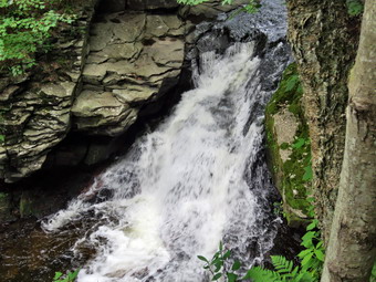 At 2:20 PM I put our gear in the car and Sheila in the back seat and headed out Old Route 17 and drove across the Flats. I took Old Route 17 and Service Road to the point where they meet Fox Mountain Road. There was one car in the parking lot which was not surprising for such a beautiful day. We started out on the trail at 2:35 PM with the temperature at 75 degrees under beautiful blue skies with a slight breeze blowing. The open trail just before the woods was barely damp but showed some erosion from the downpours that had occurred lately. We immediately ran into some mud pits with some water but less than on our last trip. One look down to the Little Beaverkill showed the stream volume was lower than our last visit but there was still a good volume of water. I wondered about the condition of the falls and whether they would be as interesting as my last trip. Sheila was taking her own route and following her nose and getting very close to the edge of the trail where a steep drop led down to the river! We began to run into some branches hanging into the trail from the side and above. I knew that Bryce and Brad might be a available soon and that two or three people can get a lot of work accomplished. I did pick up some newly fallen branches and throw them off the trail. I continued to do this for the rest of the hike as the winds from the storms had loosened branches that had then fallen on the trail. We crossed several muddy areas and were soon at the wooden walkways. I decided to take some pictures of the stream and sky. We continued over the wooden walkways and bridges which were wet and muddy from the rain. I thought about bringing a rake and a broom next time to clean off the bridges which were covered in a mixture of wet leaves and mud. This time the water from the small stream was actually flowing through the culvert under the bridge or around the edge and not onto the bridge. After crossing the bridge, we ran into another large mud pit that had a layer of water with a few stepping stones. There continued to be small branches to remove as we walked. We continued at a moderate pace as it made my foot feel better.
 At one point I looked up and saw two men coming toward us with a dog on a leash. They moved to the side of the trail and sat on a branch. We had seen them before on the trail but this was a new dog. It looked like a boxer mix and was only about a year old. He was very energetic with a loud bark. We said "Hello" and passed by quickly. Just short of the falls, we met another young man with two beautiful Labrador retrievers; one yellow and one chocolate. These dogs seemed to be a little calmer but together were giving their own quite a handful. We again greeted each other and passed by quickly. As we approached the falls, we could hear the a loud sound which was the falls. We arrived at the falls and found that there was a nice flow of water but the volume was lower than last time. The water was very clear as it flowed over the falls to the basin below. I decided not to go down to the streambed to take pictures to limit the stress on my foot and because I have quite a few pictures from the base of the falls. I took some shots of the falls from above from different locations and different angles. I also took picture upstream from this higher angle. I could see that the path along the edge of the stream was almost dry but I decided not to try my muck over the slippery rocks. We moved on down the trail passing the next bench without stopping to take pictures. We continued walking toward Parksville with Cindy and I walking together for a change which I found very enjoyable. We continued on to the end of the trail and turned around at the sign detailing the hotels in Parksville. I was still feeling comfortable and and my heel was not as painful as t had been. We met the two men with their dog again and shortly after the man with two dogs. Eventually we passed the falls and continued at a respectable pace back toward the parking area. We arrived at 4:00 PM after hiking about 2.6 miles in just under 1 hour and 30 minutes. I was very happy to get off my feet and into the air conditioning. There is virtually no elevation gain on the hike but carrying a pack helps with the exercise. There were now no cars left in the lot.
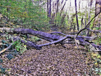
![]()
![]()
![]()
![]()
![]() On FThursday, July 27th I was scheduled to go to Frick Pond with NYS Forest Ranger Eric Stratton to remove twp blowdowns. Eric would be using a chainsaw to remove these two larger trees while I would be doing some swamping for him. The forecast for the day was for thunderstorms at 11:00 AM amd I debated whether or not we should go. In the end I decided we would try to get as much work as possible. I got up at 7:00 AM and took one ambulances down to Manor Motors for some work. I was home by 8:15 AM and I started to get ready to meet Eric. I had decided not to take Sheila but she was giving me such a pitiful look that I changed my mind! I started to get ready at 8L15 AM with the temperature at 66 degrees and a very high humidity. The skies were looking dark but I still thought we could get the work done. I put on my White Sierra long-sleeved crew top with no baselayer because of the temperature. I put on a pair of RailRiders hiking pants which are expensive but last along time and have features like deep pockets and a generous cut which I really like. I decided to put on my new Keen Durand hiking boots which I ordered a half size larger than the previous pair. These shoes fit well out of the box but get much tighter when I add a decent insole. Without the third party insole, my feet hurt from the lack of support. I added a new pair of Xstance insoles in an effort to find the best support and cushioning for my feet. These insoles have shock absorbing gel pads, TPU arch support, and memory foam cushioning all wrapped in a breathable fabric. The insoles have been hyped by their manufacturer and they really do seem to deliver. I decided to take my Leki poles with external locks as the internal twist locks sometimes fail. I did not put on any gaiters although I though about it due to the numerous ticks which had plagued me on previous hikes. I decided against taking any saws or axes as I knew the chainsaw would be able to handle everything. I got my gear in the car and put Sheila in the backseat and drove out the Debruce Road at 8:40 PM. I drive about 6 miles before turning left onto Mongaup Pond Road and continued to where the road split. I turned left onto Beech Mountain Road, and drove to the parking areas at the Frick Pond. There were no cars in either lot so I parked in the smaller parking area to wait for Eric. The car thermometer read 65 degrees. Eric drove up in his truck a few minutes later and we greeted each other with a handshake. Sheila seemed indifferent to Eric as she circled the parking area. A car drove up the road and parked in the larger lot. The occupants, a man and woman, walked over to the kiosk to check out the maps. I offered some help and gave them suggestions for routes of different lengths and difficulties. Eric got his chaining gear together and we headed out the woods road that led to the Quick Lake Trail at the register.
On FThursday, July 27th I was scheduled to go to Frick Pond with NYS Forest Ranger Eric Stratton to remove twp blowdowns. Eric would be using a chainsaw to remove these two larger trees while I would be doing some swamping for him. The forecast for the day was for thunderstorms at 11:00 AM amd I debated whether or not we should go. In the end I decided we would try to get as much work as possible. I got up at 7:00 AM and took one ambulances down to Manor Motors for some work. I was home by 8:15 AM and I started to get ready to meet Eric. I had decided not to take Sheila but she was giving me such a pitiful look that I changed my mind! I started to get ready at 8L15 AM with the temperature at 66 degrees and a very high humidity. The skies were looking dark but I still thought we could get the work done. I put on my White Sierra long-sleeved crew top with no baselayer because of the temperature. I put on a pair of RailRiders hiking pants which are expensive but last along time and have features like deep pockets and a generous cut which I really like. I decided to put on my new Keen Durand hiking boots which I ordered a half size larger than the previous pair. These shoes fit well out of the box but get much tighter when I add a decent insole. Without the third party insole, my feet hurt from the lack of support. I added a new pair of Xstance insoles in an effort to find the best support and cushioning for my feet. These insoles have shock absorbing gel pads, TPU arch support, and memory foam cushioning all wrapped in a breathable fabric. The insoles have been hyped by their manufacturer and they really do seem to deliver. I decided to take my Leki poles with external locks as the internal twist locks sometimes fail. I did not put on any gaiters although I though about it due to the numerous ticks which had plagued me on previous hikes. I decided against taking any saws or axes as I knew the chainsaw would be able to handle everything. I got my gear in the car and put Sheila in the backseat and drove out the Debruce Road at 8:40 PM. I drive about 6 miles before turning left onto Mongaup Pond Road and continued to where the road split. I turned left onto Beech Mountain Road, and drove to the parking areas at the Frick Pond. There were no cars in either lot so I parked in the smaller parking area to wait for Eric. The car thermometer read 65 degrees. Eric drove up in his truck a few minutes later and we greeted each other with a handshake. Sheila seemed indifferent to Eric as she circled the parking area. A car drove up the road and parked in the larger lot. The occupants, a man and woman, walked over to the kiosk to check out the maps. I offered some help and gave them suggestions for routes of different lengths and difficulties. Eric got his chaining gear together and we headed out the woods road that led to the Quick Lake Trail at the register.
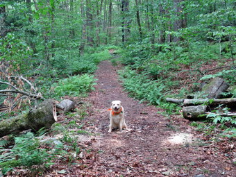 My plan was to cut a blowdown across the Big Rock Trail at the head end of Frick Pond First. This blowdown made doing the loop around Frick Pond more difficult. This loop is the one I often suggest for beginners and I wanted to make sure it was as easy as possible. When we were done with this blowdown, we could try to get the one on the Flynn Trail right out of the parking area if the rain held off. The woods road was damp with a few muddy places and a little standing water. We continued straight ahead at the register and headed out the woods road toward Frick Pond. The trail was damp with just a little standing and running water and only a few muddy places. At Gravestone Junction, we turned right to get on the Logger's Loop heading toward Times Square. The grass and brush was overgrowing the trail because the long-time maintainer had hung up her loppers in June. I thought about getting a small crew together and bringing my string trimmer to make the experience more enjoyable. The grass was a little damp but not enough to soak my shoes or pants. The sky was overcast and occasionally I though IU could feel a raindrop! We walked passed the designated campsites which were empty and followed the trail as it turned a little to the left to parallel the eastern shore of Frick Pond. There are usually some wet and muddy spots along the way and this day was no exception. The trail is usually lower than the surrounding area so water collects on it and is very hard to drain. We stayed on the main trail and avoided the "detours" which hikers had created. We topped the small hill and began walking down the other side. As we walked, we talked. Eric is a very interesting hiking partner and very passionate about his job. He is very knowledgeable on many subjects and works with the fire department and ambulance corps on skills training.
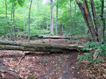 We continued to Times Square on the Logger's Loop where we turned left and started the short loop around Frick Pond which I knew was barely 2 miles. The Big Rock Trail had some damp areas and some that were pretty muddy. We came to the blowdown which extended across the entire trail. I had cut off some of the branches leaving the top smooth enough for hikers to get over it. I quickly leashed Sheila to a tree so that she would be safe. I took some "before" pictures as Eric got the chainsaw ready. As a Forest Ranger Eric knows how dangerous a chainsaw can be and makes sure he has Kevlar chaps and a helmet with hearing protection. Eric started to make cuts on the tree and found it was hollow which made it cutting easier. As Eric cut section out of the trunk, I was able to roll them away and flip them off the trail. It didn't take much time at all to remove the entire tree! I pocked up a few stray branches and then took some "after" shots. Eric packed up the saw but we lingered for some time to allow the saw to cool. We decided to do the loop around Frick Pond for variety. We crossed the bridges over the outlet streams and I stopped to take a few pictures. The water was rather high as we had gotten some rain and all the plants were very green. We entered the spruce forest which is always a treat. The wooden walkways were almost dry and, therefore, not very slippery. When we reached the end of the Big Rock Trail, we turned left on the Quick Lake Trail to head toward the bridge across the outlet of Frick Pond. The trail was damp including the place that is usually a mud pit. At the bridge, I stopped and dropped my pack to take a few pictures even though I have hundreds and maybe thousands from this same spot. I put the camera away and shouldered my pack to walk up the hill to Gravestone Junction. We walked back along the Quick Lake Trail and the woods road to the parking area.
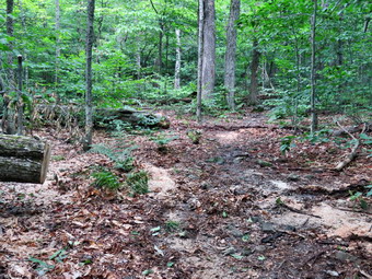 We continued across the road to the beginning of the Fynn Trail and started through the woods. Withing a few hundred feet we came to two large trees that nad blown down across the trail. These trees had almost blocked the trail until I cut most of the smaller branches and dragged them away. This opened the trail up so that hikers simply had to step over the two remaining large trunks. I took some pictures of the blowdowns amd then leashed Sheila to a tree a distance away from where W Eric and I would be working. I hoped that the sections Eric cut would roll downhill amd that I could then encourage off the trail. Eric got ready and fired up the chainsaw. He cut a large section from the first trunk which proved to be quite solid. This section did roll downhill but stopped on the trail. I was able to pick up one end and flip it off the trail. The next section was also large and this one did roll toward the edge of the trail stopping up against a small sapling. This one I could not move the way I wanted until Eric helped out. We were able to roll the section off the trail. One more cut and the first blowdown was done. Eric began to slice up the second trunk which was smaller. It was only a few minutes until the job was done. I took my "after" pictures and cleaned up a few branches. Eric packed up his gear and we headed back to the parking area. I noted that it was almost 11:30 Am and that there had been no rain. We had hike a little over 2 miles but the bigger accomplishment was getting the work done that I had planned. The walking and the work had taken about 2 and a half hours. Sometimes I like to think I can do as much work with hand saws and axes in about the same time as a chain saw. Everything can be cleared with hand tools but a chainsaw really does come in handy. Thanks to Forest Ranger Eric Stratton!
![]()
![]()
![]()
![]() On Wednesday, July 26th I wanted to get out for a hike after a 12 day hiatus. Mostly I had been nursing a painful right foot by resting it and stretching my lower legs. Over the weekend I had gone with my son Karl to a triathlon on Sandusky, Ohio. It was nice to be away with him and away from the ambulance pager! On Wednesday morning Cindy and I went down to the ambulance building to talk to a group of third and fourth graders about the ambulance services. When we returned home, I got some lunch and did a few jobs before deciding to get ready to hike a 2:30 PM> I decided to go across the street and hike on Round Top as I could cover ambulance from there and I could abort the hike easily if my foot began to bother me. The temperature was 84 degrees on the back porch so I decided to wear my White Sierra long-sleeved crew shirt without a baselayer. I wore my Railriders hiking pants which are expensive but last along time and have features like deep pockets and a generous cut which I really like. The pants have Velcro closures at the ankles. I decided to put on my new Keen Durand hiking boots which I ordered a half size larger than the previous pair. These shoes fit well out of the box but get much tighter when I add a decent insole. Without the third party insole, my feet hurt from the lack of support. I added a new pair of Xstance insoles in an effort to find the best support and cushioning for my feet. These insoles have shock absorbing gel pads, TPU arch support, and memory foam cushioning all wrapped in a breathable fabric. The insoles have been hyped by their manufacturer and they really do seem to deliver. I decided to take my Leki poles with external locks as the internal twist locks sometimes fail. I did not put on any gaiters although I though about it due to the numerous ticks which had plagued me on previous hikes. I put my phone in my pocket and grabbed Sheila's leash from my trunk as we walked up the driveway at 2:50 PM. We walked across the street and to the parking lot of the Presbyterian Church. We walked behind the church to get to the road up the hill to the trailhead. We began the ascent of the steepest hill behind the church. The hill is short but gets the circulation pumping and is the steepest and longest climb on the "trail." It seemed very hot and humid but Sheila was giving me some help as she pulled on her leash. My goal is always to make it all the way up the hill without stopping which I was able to do even though I had not hiked in a long time.
On Wednesday, July 26th I wanted to get out for a hike after a 12 day hiatus. Mostly I had been nursing a painful right foot by resting it and stretching my lower legs. Over the weekend I had gone with my son Karl to a triathlon on Sandusky, Ohio. It was nice to be away with him and away from the ambulance pager! On Wednesday morning Cindy and I went down to the ambulance building to talk to a group of third and fourth graders about the ambulance services. When we returned home, I got some lunch and did a few jobs before deciding to get ready to hike a 2:30 PM> I decided to go across the street and hike on Round Top as I could cover ambulance from there and I could abort the hike easily if my foot began to bother me. The temperature was 84 degrees on the back porch so I decided to wear my White Sierra long-sleeved crew shirt without a baselayer. I wore my Railriders hiking pants which are expensive but last along time and have features like deep pockets and a generous cut which I really like. The pants have Velcro closures at the ankles. I decided to put on my new Keen Durand hiking boots which I ordered a half size larger than the previous pair. These shoes fit well out of the box but get much tighter when I add a decent insole. Without the third party insole, my feet hurt from the lack of support. I added a new pair of Xstance insoles in an effort to find the best support and cushioning for my feet. These insoles have shock absorbing gel pads, TPU arch support, and memory foam cushioning all wrapped in a breathable fabric. The insoles have been hyped by their manufacturer and they really do seem to deliver. I decided to take my Leki poles with external locks as the internal twist locks sometimes fail. I did not put on any gaiters although I though about it due to the numerous ticks which had plagued me on previous hikes. I put my phone in my pocket and grabbed Sheila's leash from my trunk as we walked up the driveway at 2:50 PM. We walked across the street and to the parking lot of the Presbyterian Church. We walked behind the church to get to the road up the hill to the trailhead. We began the ascent of the steepest hill behind the church. The hill is short but gets the circulation pumping and is the steepest and longest climb on the "trail." It seemed very hot and humid but Sheila was giving me some help as she pulled on her leash. My goal is always to make it all the way up the hill without stopping which I was able to do even though I had not hiked in a long time.
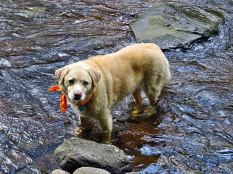
![]()
![]()
![]()
![]()
![]() On Monday, July 3rd I wanted to get out for a hike but had to try to plan around the numerous ambulance calls we had been getting. I finally decided I would go to the Parksville Rail Trail and trim some of the bushes and branches hanging into the trail. I asked Cindy if she would like to go along to help trim the trail and she said "Yes" despite the 80 degree heat and high humidity. We started to get ready at 2:30 PM with Sheila keeping a watchful eye on both of us. One look outside showed a blue skies and many puffy white clouds in one direction and swirling faker clouds in the other. The Parksville Rail Trail which is about 2.5 miles with a beautiful waterfall. This choice would also allow my to respond on an ambulance call even if I was a little delayed. We had been hiking more regularly since April but as I was getting dressed it looked as if Sheila thought we might not hike again! I decided to wear my White Sierra long-sleeved crew shirt without a baselayer. I wore my Railriders hiking pants which are expensive but last along time and have features like deep pockets and a generous cut which I really like. The pants have Velcro closures at the ankles. I decided to put on my new Keen Durand hiking boots which I ordered a half size larger than the previous pair. These shoes fit well out of the box but get much tighter when I add a decent insole. Without the third party insole, by feet hurt from the lack of support. I added a new pair of Xstance insoles in an effort to find the best support and cushioning for my feet. These insoles have shock absorbing gel pads, TPU arch support, and memory foam cushioning all wrapped in a breathable fabric. The insoles have been hyped by their manufacturer and they really do seem to deliver. I decided to take my Leki poles with external locks as the internal twist locks sometimes fail. I put on any gaiters as I thought about the numerous ticks which had plagued me on previous hikes. I also wore my OR brimmed hat as it acts as a base for insect repellant. I put my Corona loppers in the car. These have extendible handles and are best for larger branches.
On Monday, July 3rd I wanted to get out for a hike but had to try to plan around the numerous ambulance calls we had been getting. I finally decided I would go to the Parksville Rail Trail and trim some of the bushes and branches hanging into the trail. I asked Cindy if she would like to go along to help trim the trail and she said "Yes" despite the 80 degree heat and high humidity. We started to get ready at 2:30 PM with Sheila keeping a watchful eye on both of us. One look outside showed a blue skies and many puffy white clouds in one direction and swirling faker clouds in the other. The Parksville Rail Trail which is about 2.5 miles with a beautiful waterfall. This choice would also allow my to respond on an ambulance call even if I was a little delayed. We had been hiking more regularly since April but as I was getting dressed it looked as if Sheila thought we might not hike again! I decided to wear my White Sierra long-sleeved crew shirt without a baselayer. I wore my Railriders hiking pants which are expensive but last along time and have features like deep pockets and a generous cut which I really like. The pants have Velcro closures at the ankles. I decided to put on my new Keen Durand hiking boots which I ordered a half size larger than the previous pair. These shoes fit well out of the box but get much tighter when I add a decent insole. Without the third party insole, by feet hurt from the lack of support. I added a new pair of Xstance insoles in an effort to find the best support and cushioning for my feet. These insoles have shock absorbing gel pads, TPU arch support, and memory foam cushioning all wrapped in a breathable fabric. The insoles have been hyped by their manufacturer and they really do seem to deliver. I decided to take my Leki poles with external locks as the internal twist locks sometimes fail. I put on any gaiters as I thought about the numerous ticks which had plagued me on previous hikes. I also wore my OR brimmed hat as it acts as a base for insect repellant. I put my Corona loppers in the car. These have extendible handles and are best for larger branches.
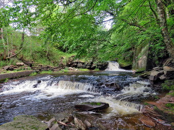 At 2:45 PM I put our gear in the car and Sheila in the back seat and headed out Old Route 17 and drove across the Flats. I took Old Route 17 and Service Road to the point where they meet Fox Mountain Road. There was one cars in the parking lot which was not surprising for such a beautiful day on a long weekend. A young couple had their child with them and it looked as if they had just finished biking the trail. We started out on the trail at 3:00 PM with the temperature at 80 degrees under variable skies with a slight breeze blowing. I had decided to walk the trail and then trim the bushes on the first part when we returned. I could not remember many other places that needed to be lopped. The open trail just before the woods was damp. There had been two periods when quite a bit of rain after a short drought so I expected water on the trail and a good volume in the stream. We immediately ran into some mud pits with quite a bit of water. One look down to the Little Beaverkill showed the stream volume was higher than our last visit. I wondered about the condition of the falls and whether they would be as interesting as my last trip. Sheila was taking her own route and following her nose and getting very close to the edge of the trail where a steep drop led down to the river! We began to run into some branches hanging into the trail from the side and above. I decided to go back to the car and exchange my poles for the loppers. I left Cindy with Sheila on her leash and quickly hiked back to the car and then back to where Cindy had stopped. I started to trim some small branches as Cindy watched me. I started to pick up the branches and throw them off the trail. Cindy eventually joined me but did not seem very enthusiastic. I asked Cindy to pull some branches down from above which allowed me to reach higher and cut them off up high/ I threw the branches off to the trail and we continued our hike. I continued to cut branches as Cindy walked on uo the trail leaving me to cut and move the cut branches. It was clear she was done for the day and that I would have to continue on my won. This was very discouraging as we had worked in the past. Working with somebody makes everything much easier. I crossed several muddy areas and continued to try to cut and remove branches. There were many more branches than I thought and I began to imagine how much easier the job would be if Bryce was with me! Eventually I decided that I was not willing to continue to trim by myself. I looked up to see Cindy far ahead of me. I dolled the loppers and picked up my hiking pace. We were soon at the wooden walkways and I decided not to any pictures. We continued over the wooden walkways and bridges which were wet from the rain. I thought about bringing a rake and a broom next time to clean off the bridges which were covered in a mixture of wet leaves and mud. This time the water from the small stream was actually flowing through the culvert under the bridge or around the edge and not onto the bridge. After crossing the bridge, we ran into another large mud pit that had a layer of water with a few stepping stones. There continued to be small branches to remove as we walked. I was disappointed that there were also many branches to trim. I continued at a fast pace even though the heat and humidity was exhausting. As we approached the falls, we could hear the a loud sound which was the falls. We arrived at the falls and found that there was a nice flow of water and the volume was higher than last time due to the rain. I water was also a little muddy from the erosion of the surrounding alnd
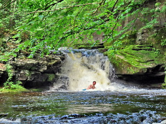 I decided to take Sheila down to the streambed to take some pictures. I left the loppers on the picnic table as we descended the bank with Shiela leading and me close behind. It was a little more difficult without my poles. I dropped my pack and took out the camera. It was then that I noticed three young mean swimming on the water below the falls. I knew that if I captured them in my pictures I could easily remove them so I continued with my plan. I took a picture of Sheila standing in the stream and some more shots downstream before turning my attention to the falls. I took some shots of the rapids before the falls and then some of the main falls. I finished by taking some pictures of both falls. We climbed back to the main trail and I took some more shots of the falls from above. I also took picture upstream from this higher angle. At this point I noticed that my heels were hurting with the right being much worse than the left, I took an ibuprofen and decided to continue to the Parksville end of the trail. We moved on down the trail passing the next bench without stopping to take pictures. We continued walking toward Parksville with Cindy and I setting different paces and hiking our own hikes. I found a few more wet and muddy areas on the trail but they were easy to walk around. As I walked a group if three young machining toward us. They had a speaker turned up nice and loud so that everyone could hear their music. I was a little put off because I like the quiet of the hoe but I realized that they were enjoying their music. I continued on to the end of the trail and turned around at the sign detailing the hotels in Parksville. I turned around at 4:15 PM and started the walk back. I was hot and sweaty and my heel was hurrying so I was really dragging along. I eventually passed the falls with Cindy far ahead of me. Sheila stayed with me to keep me company which did cheer me up. I continued to walk back to the car arriving at 5"00 PM after hiking about 2.6 miles. I was very happy to get off my feet and into the air conditioning. There is virtually no elevation gain on the hike but carrying a pack and doing some trimming helps with the exercise. There were now no cars left in the lot. I drove back home dropping Cindy and Sheila out from while I continued on to the ambulance building to check on the rigs.
![]()
![]()
![]()
![]() On Wednesday, July 12th, I wanted to get out for a longer hike after sticking to Round Top and trails near home for several walks. I planned to get up early and head to Frick Pond to do the 6 mile loop around Frick and Hodge Ponds. The ambulance pager woke me up in the morning and I was off on a call in Liberty which turned out not to be a call at all! I returned home after documenting the call and started to get ready to hike at 12:15 PM despite the darkening skies. No rain was predicted and I decided I didn't care if I got wet anyway as long as there was no lightning. As I started to get ready, the temperature on the back porch was 75 degrees with a slight breeze! I decided to wear my White Sierra long-sleeved crew shirt without a baselayer. I wore my Railriders hiking pants which are expensive but last along time and have features like deep pockets and a generous cut which I really like. The pants have Velcro closures at the ankles. I decided to put on my new Keen Durand hiking boots which I ordered a half size larger than the previous pair. These shoes fit well out of the box but get much tighter when I add a decent insole. Without the third party insole, by feet hurt from the lack of support. I added a new pair of Xstance insoles in an effort to find the best support and cushioning for my feet. These insoles have shock absorbing gel pads, TPU arch support, and memory foam cushioning all wrapped in a breathable fabric. The insoles have been hyped by their manufacturer and they really do seem to deliver. I decided to take my Leki poles with external locks as the internal twist locks sometimes fail. I put on any gaiters as I thought about the numerous ticks which had plagued me on previous hikes. I also wore my OR brimmed hat as it acts as a base for insect repellant. I put my Silky Sugowaza saw in my pack as I decided I would cut a few blowdowns that I knew were on the Flynn Trail. I put my gear in the back and Sheila in the backseat and headed out the DeBruce Road at 9:30 AM. After 6 miles, at Mongaup Pond Road, I turned left and continued to follow the road bearing left onto Beech Mountain Road at the fork. When we arrived in the parking area there were four cars parked in the larger lot and the small lot also had four cars. I was surprised so many people were in the area on a Wednesday. I pulled into the smaller lot with Sheila acting as if she hadn't hiked in a month as she ran around and headed for the trail. The temperature was 75 degrees and the skies were a mix of blue and gathering darkness with a slight breeze blowing. I could see the insects swarming so I sprayed some insect repellant on my hat, exposed skin, and hiking top. We got ready to head out on the Flynn Trail as the dog from the cabin started down the driveway toward us. We crossed the road and began our hike at 1:0f PM.
On Wednesday, July 12th, I wanted to get out for a longer hike after sticking to Round Top and trails near home for several walks. I planned to get up early and head to Frick Pond to do the 6 mile loop around Frick and Hodge Ponds. The ambulance pager woke me up in the morning and I was off on a call in Liberty which turned out not to be a call at all! I returned home after documenting the call and started to get ready to hike at 12:15 PM despite the darkening skies. No rain was predicted and I decided I didn't care if I got wet anyway as long as there was no lightning. As I started to get ready, the temperature on the back porch was 75 degrees with a slight breeze! I decided to wear my White Sierra long-sleeved crew shirt without a baselayer. I wore my Railriders hiking pants which are expensive but last along time and have features like deep pockets and a generous cut which I really like. The pants have Velcro closures at the ankles. I decided to put on my new Keen Durand hiking boots which I ordered a half size larger than the previous pair. These shoes fit well out of the box but get much tighter when I add a decent insole. Without the third party insole, by feet hurt from the lack of support. I added a new pair of Xstance insoles in an effort to find the best support and cushioning for my feet. These insoles have shock absorbing gel pads, TPU arch support, and memory foam cushioning all wrapped in a breathable fabric. The insoles have been hyped by their manufacturer and they really do seem to deliver. I decided to take my Leki poles with external locks as the internal twist locks sometimes fail. I put on any gaiters as I thought about the numerous ticks which had plagued me on previous hikes. I also wore my OR brimmed hat as it acts as a base for insect repellant. I put my Silky Sugowaza saw in my pack as I decided I would cut a few blowdowns that I knew were on the Flynn Trail. I put my gear in the back and Sheila in the backseat and headed out the DeBruce Road at 9:30 AM. After 6 miles, at Mongaup Pond Road, I turned left and continued to follow the road bearing left onto Beech Mountain Road at the fork. When we arrived in the parking area there were four cars parked in the larger lot and the small lot also had four cars. I was surprised so many people were in the area on a Wednesday. I pulled into the smaller lot with Sheila acting as if she hadn't hiked in a month as she ran around and headed for the trail. The temperature was 75 degrees and the skies were a mix of blue and gathering darkness with a slight breeze blowing. I could see the insects swarming so I sprayed some insect repellant on my hat, exposed skin, and hiking top. We got ready to head out on the Flynn Trail as the dog from the cabin started down the driveway toward us. We crossed the road and began our hike at 1:0f PM.
The Flynn Trail is sited along what used to be Beech Mountain Road which was the access for the Beech Mountain Boy Scout Camp. We walked the trail through the woods which was wet from the rain the days before. I immediately noticed that although my Achilles tendons were still aching with every step I was keeping up a good pace. After a short walk we came to the first blowdown that I knew was present. The problem was that a large tree had fallen across the trail and its 2 foot diameter was more than I could handle, at least on this day. I had cut and removed the other trees that had been brought down and were encroaching on the trail or hanging over it. I managed to schedule a date with the local ranger to cut this and some other large blowdowns. We continued on the Flynn Trail and turned right on the woods road and continued to set a good pace up the hill. I was surprised that the other dog was barking but not following us. The trail gains a little over 600 feet in 1.7 miles to the highest point at the junction with the Big Rock Trail. We passed the hemlock that used to form a tunnel but was cleared by the DEC. Just after this there were several medium sized trees down across the trail. I put my pack down to get out my camera. I had checked that I had my camera before leaving the house but found I had the cover but not the camera! So instead of taking epicures, I got out my saw and started to strip small branches off the larger trunk. After cutting the smallest, I began to cut larger ones and drag them off the trail. I finally had just the larger trunk remaining so I cut it at a point off the trail. I finished the cut through trunk and then dragged this larger pieces off the trail. After cleaning up a few small branches, we moved up the trail to the next blowdown. This blowdown was a single small trunk across the trail. As I prepared to make the cut, we saw a hiker coming down the trail toward us. I told Sheila to move to the side of the trail and to lie down. I began the cut as the hiker approached. He had a single bottle of water and gave me a "Thank you" as he passed. The wood was a little harder than I thought but I finished the cut. I thought I might have to make another cut but was able to pick up the trunk and pivot it off the trail. I put the saw in my pack and cleaned up the trail before moving on. I noticed that I was very relaxed and decided I needed to get out more as the other things that I do can be stressful.
We continued up the Flynn Trail as the skies grew darker all the time. Another hiker came toward us and we greeted each other. He said He had walked up to Hodge Pond and now was going back. He commented that when he started it was bright and sunny and that it seemed rain was now coming. I hope he was wrong and we continued in opposite directions. We ran across another blowdown which required several cuts to remove individual branches. I cut the larger trunk and was able to drag large sections off the trail. I cut the larger trunk and was able to lift and pivot it off the trail. Since it was now parallel to the trail, I rolled it off a little farther. We came to the clearing on the right side of the trail and walked quickly passed it. A few drops of rain began to fall but I chose to ignore them. The trail drops a little before ascending again to the junction with the Big Rick Trail. Just as the trail flattened we came to another medium sized trunk suspended across the trail. I knew it would be easiest to use an ax but I did not have one. I decided to try using the saw although it looked to me like it was likely I would get it hung up! As I made the first cut just off the right side of the trail, the rain began to fall in earnest. I went to my pack, got out the cover, and out it on the pack. I went back to try to complete the cut but the saw was starting to jam in the wet wood. I decided we would move on. I stashed the saw in my pack and we continued on to the junction with the Big Rock Trail. When we arrived 2:15 PM, the rain was really coming down. I decided we would return by walking back down the Flynn Trail. We turned around and set a fast pace. My right heel had a sharp pain but I continued to push the pace. We were soon approaching the gate on the Flynn Trail where we turned left and walked the trail to the woods back to the parking area. As we came out of the woods the rain had all but stopped and the sun was coming out. To my surprise only one of the seven cars remained! We arrived at the car at 3:05 PM having hiked 3.5 miles in 2 hours including the time spent cutting trees. The temperature was 74 degrees.
![]()
![]()
![]()
![]() On Saturday, July 8th my grandson Bryce was at our house for the weekend while his parents attended a wedding. On Friday Bryce and I had started a hike at Frick Pond but the rains came and we tuned back. I was not scared of getting wet but the thunder and lightening bothered me! Saturday morning I was scheduled to pickup a Finger Lakes Trail hiker at the Balsam Lake Mounatin parking area and shuttle him to Alder Lake. Bryce decided to go along as I was going to my church afterward to prepare for Sunday's service. We left the house at 7:45 Am and drove to the end of the Beaverkill Road arriving at 8:30AM. Louis was already waiting so we immediately headed back down the Beaverkill Road to Alder Lake where we dropped Louis at about 9:00 AM. The church is on Fuller Hill Road in Horton and I debated the best way to get there. I decided to drive over Cross Mountain Road to Millbrook Road. The road is dirt and gravel most of the way and very narrow. Fortunately, we did not meet any other cars but the road is every bit as interesting as I remember. We followed Millbrook Road out to the Pepacton Reservoir> from There we took Route 30 to Downsville and west to Corbett. Out of Corbett we took Fuller Hill Road to the church where I did the work I needed to complete. We drove home and were in the driveway by 12:30 POM. Bryce got some lunch as the skies outside began to show signs of some rain. We decided to go across the street and hike on Round Top as I could cover ambulance from there and we could abort the hike easily if there was any thunder or lightening. We started to get ready at 1:30 PM with the temperature at 84 degrees on the back porch. I decided to wear my White Sierra long-sleeved crew shirt without a baselayer. I wore my Railriders hiking pants which are expensive but last along time and have features like deep pockets and a generous cut which I really like. The pants have Velcro closures at the ankles. I decided to put on my new Keen Durand hiking boots which I ordered a half size larger than the previous pair. These shoes fit well out of the box but get much tighter when I add a decent insole. Without the third party insole, by feet hurt from the lack of support. I added a new pair of Xstance insoles in an effort to find the best support and cushioning for my feet. These insoles have shock absorbing gel pads, TPU arch support, and memory foam cushioning all wrapped in a breathable fabric. The insoles have been hyped by their manufacturer and they really do seem to deliver. I decided to take my Leki poles with external locks as the internal twist locks sometimes fail. I did not put on any gaiters although I though about it due to the numerous ticks which had plagued me on previous hikes. Bryce is 12 years old and now taller than I am. He had a short-sleeved shirt and shorts so I knew we would have to do a good "tick check" when we got home. I gave Bryce my phone to carry while I grabbed Sheila's leash from my trunk as we walked up the driveway at 1:45 PM. We walked across the street and to the parking lot of the Presbyterian Church. We walked behind the church to get to the road up the hill to the trailhead. We began the ascent of the steepest hill behind the church. The hill is short but gets the circulation pumping and is the steepest and longest climb on the "trail." It seemed very hot and humid but Sheila was giving me some help as she pulled on her leash. My goal is always to make it all the way up the hill without stopping which I was able to do by picking the right pace.
On Saturday, July 8th my grandson Bryce was at our house for the weekend while his parents attended a wedding. On Friday Bryce and I had started a hike at Frick Pond but the rains came and we tuned back. I was not scared of getting wet but the thunder and lightening bothered me! Saturday morning I was scheduled to pickup a Finger Lakes Trail hiker at the Balsam Lake Mounatin parking area and shuttle him to Alder Lake. Bryce decided to go along as I was going to my church afterward to prepare for Sunday's service. We left the house at 7:45 Am and drove to the end of the Beaverkill Road arriving at 8:30AM. Louis was already waiting so we immediately headed back down the Beaverkill Road to Alder Lake where we dropped Louis at about 9:00 AM. The church is on Fuller Hill Road in Horton and I debated the best way to get there. I decided to drive over Cross Mountain Road to Millbrook Road. The road is dirt and gravel most of the way and very narrow. Fortunately, we did not meet any other cars but the road is every bit as interesting as I remember. We followed Millbrook Road out to the Pepacton Reservoir> from There we took Route 30 to Downsville and west to Corbett. Out of Corbett we took Fuller Hill Road to the church where I did the work I needed to complete. We drove home and were in the driveway by 12:30 POM. Bryce got some lunch as the skies outside began to show signs of some rain. We decided to go across the street and hike on Round Top as I could cover ambulance from there and we could abort the hike easily if there was any thunder or lightening. We started to get ready at 1:30 PM with the temperature at 84 degrees on the back porch. I decided to wear my White Sierra long-sleeved crew shirt without a baselayer. I wore my Railriders hiking pants which are expensive but last along time and have features like deep pockets and a generous cut which I really like. The pants have Velcro closures at the ankles. I decided to put on my new Keen Durand hiking boots which I ordered a half size larger than the previous pair. These shoes fit well out of the box but get much tighter when I add a decent insole. Without the third party insole, by feet hurt from the lack of support. I added a new pair of Xstance insoles in an effort to find the best support and cushioning for my feet. These insoles have shock absorbing gel pads, TPU arch support, and memory foam cushioning all wrapped in a breathable fabric. The insoles have been hyped by their manufacturer and they really do seem to deliver. I decided to take my Leki poles with external locks as the internal twist locks sometimes fail. I did not put on any gaiters although I though about it due to the numerous ticks which had plagued me on previous hikes. Bryce is 12 years old and now taller than I am. He had a short-sleeved shirt and shorts so I knew we would have to do a good "tick check" when we got home. I gave Bryce my phone to carry while I grabbed Sheila's leash from my trunk as we walked up the driveway at 1:45 PM. We walked across the street and to the parking lot of the Presbyterian Church. We walked behind the church to get to the road up the hill to the trailhead. We began the ascent of the steepest hill behind the church. The hill is short but gets the circulation pumping and is the steepest and longest climb on the "trail." It seemed very hot and humid but Sheila was giving me some help as she pulled on her leash. My goal is always to make it all the way up the hill without stopping which I was able to do by picking the right pace.
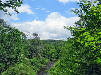
![]()
![]()
![]()
![]()
![]() On Monday, July 3rd I wanted to get out for a hike but had to try to plan around the numerous ambulance calls we had been getting. I finally decided I would go to the Parksville Rail Trail. I asked Cindy if she would like to go for a walk and she said "Yes" despite the 80 degree heat and high humidity. We started to get ready at 12:30 PM with Sheila keeping a watchful eye on both of us. One look outside showed a blue skies with many puffy white clouds. The Parksville Rail Trail which is about 2.5 miles with a beautiful waterfall. This choice would also allow my to respond on an ambulance call even if I was a little delayed. We had been hiking more regularly since April but as I was getting dressed it looked as if she thought we might not hike again! I decided to wear my White Sierra long-sleeved crew shirt without a baselayer. I wore my Railriders hiking pants which are expensive but last along time and have features like deep pockets and a generous cut which I really like. The pants have Velcro closures at the ankles. I decided to put on my new Keen Durand hiking boots which I ordered a half size larger than the previous pair. These shoes fit well out of the box but get much tighter when I add a decent insole. Without the third party insole, by feet hurt from the lack of support. I added a new pair of Xstance insoles in an effort to find the best support and cushioning for my feet. These insoles have shock absorbing gel pads, TPU arch support, and memory foam cushioning all wrapped in a breathable fabric. The insoles have been hyped by their manufacturer and they really do seem to deliver. I decided to take my Leki poles with external locks as the internal twist locks sometimes fail.
On Monday, July 3rd I wanted to get out for a hike but had to try to plan around the numerous ambulance calls we had been getting. I finally decided I would go to the Parksville Rail Trail. I asked Cindy if she would like to go for a walk and she said "Yes" despite the 80 degree heat and high humidity. We started to get ready at 12:30 PM with Sheila keeping a watchful eye on both of us. One look outside showed a blue skies with many puffy white clouds. The Parksville Rail Trail which is about 2.5 miles with a beautiful waterfall. This choice would also allow my to respond on an ambulance call even if I was a little delayed. We had been hiking more regularly since April but as I was getting dressed it looked as if she thought we might not hike again! I decided to wear my White Sierra long-sleeved crew shirt without a baselayer. I wore my Railriders hiking pants which are expensive but last along time and have features like deep pockets and a generous cut which I really like. The pants have Velcro closures at the ankles. I decided to put on my new Keen Durand hiking boots which I ordered a half size larger than the previous pair. These shoes fit well out of the box but get much tighter when I add a decent insole. Without the third party insole, by feet hurt from the lack of support. I added a new pair of Xstance insoles in an effort to find the best support and cushioning for my feet. These insoles have shock absorbing gel pads, TPU arch support, and memory foam cushioning all wrapped in a breathable fabric. The insoles have been hyped by their manufacturer and they really do seem to deliver. I decided to take my Leki poles with external locks as the internal twist locks sometimes fail.
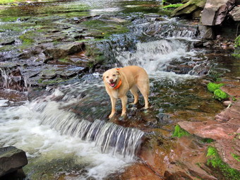 At 1:00 PM I put our gear in the car and Sheila in the back seat and headed out Old Route 17 and drove across the Flats. I took Old Route 17 and Service Road to the point where they meet Fox Mountain Road. There were four cars in the parking lot which was not surprising for such a beautiful day on a long weekend. We started out on the trail at 1:15 PM with the temperature at 79 degrees under skies with puffy white clouds but no breeze. The open trail just before the woods was damp. Usually as we enter the trees the temperature seems to drop and this was true on this day as we were out of the direct rays of the sun. There had been quite a bit of rain after a short drought so we did not know what to expect on the trail. We immediately ran into some mud pits but they were almost completely dried up. One look down to the Little Beaverkill showed the stream volume was higher than our last visit. I wondered about the condition of the falls and whether they would be as interesting as my last trip. Sheila was taking her own route and following her nose and getting very close to the edge of the trail where a steep drop led down to the river! We looked up to see a couple coming toward us with two dogs. I walked off the trail and took Sheila with me as the other hikers passed. We were soon at the wooden walkways and I decided to take some pictures down to the river. The backdrop for the pictures were the very puffy white clouds and the green leaves. After I took a few shots we continued our walk. We continued over the wooden walkways and bridges which were damp from the rain. I thought about bringing a rake and a broom next time to clean off the bridges. There were also some small branches that needed lopping or cutting with a small saw. This time the water from the small stream was actually flowing through the culvert under the bridge. After crossing the bridge, we ran into another large mud pit that had a thin layer of water with a few stepping stones. There continued to be small branches to remove as we walked. We continued at a fast pace even tough the heat and humidity was wearing. As we approached the falls, we could hear the sound of the falls. We arrived at the falls and found that there was a nice flow of crystal-clear water and the volume was higher than last time due to the rain.
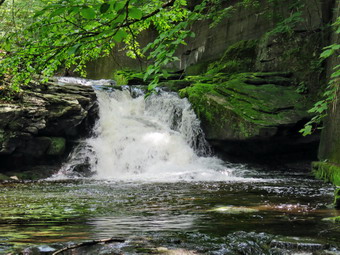 Another couple was coming toward us with a small but very loud dog that snarled and barked continuously. I decided to take Sheila down to the streambed to get away from the other dog and to take some pictures. We descended the bank with Shiela leading and me close behind. I dropped my pack and took out the camera. It was then that I notice a young woman sitting on the rocks on the opposite shore. We waved and then I took a picture of Sheila standing in the stream. I took some more shots downstream and the turned my attention to the falls. I took some shots of the rapids before the falls and then some of the main falls. I finished by taking some pictures of both falls. I thought I was done until I saw Sheila walking to some rocks in front of the falls and posed. I obliged by taking some shots of her and a few more as she repositioned herself. We finished and I noticed a young man walking across the stream. I called Sheila to make sure she stayed near me. As we began to climb back up the bank, the young man said "She poses like a model!" I had to agree and thanked him. We climbed back to the main trail and I took some more shots of the falls from above. I also took picture upstream from this higher angle. We moved on down the trail to the next bench where I put down my pack and again took out the camera. There was a couple sitting at the place where I sometimes take pictures so I chose to walk the math down to the streambed toward the falls. I did not get very far as the rocks were very slippery and the water was high enough to cover the path. I did take some pictures from this angle before walking back up to the bench and stowing the camera. We continued walking toward Parksville to get a little more distance. We found a few more damp areas on the trail but they were easy to walk around. We continued on to the end of the trail and turned around at the sign detailing the hotels in Parksville. We turned around at 2:05 PM and set a fast pace back toward the car passing the falls on the way. We passed a group of four young people who appeared to be headed for dip in the falls. We continued to walk back to the car arriving at 2:50 PM after hiking about 2.6 miles There is virtually no elevation gain on the hike but carrying a pack and walking quickly helps with the exercise. There were now seven cars parked in the lot which I think is more than I have ever seen at one time! I drove back home and parked in the driveway.
![]()
![]()
![]()
![]() On Thursday, June 22nd I wanted to get out for hike on Te first full day of summer. The beginning of the week had been filled with meetings and mnbulance calls and I needed a break! I asked Cindy if she would like to hike the Parksville Rail Trail from Fox Mountain Road to Old Liberty Road near Livingston Manor. She said "Yes" so we started getting ready at 11:15 Am with the temperate at 71 degrees. I got dressed in my White Sierra light crew top which blocks the sun and isn't too warm. I wore my Railriders hiking pants which are expensive but last along time and have features like deep pockets and a generous cut which I really like. The pants have Velcro closures at the ankles. I decided to put on my new Keen Durand hiking boots which I ordered a half size larger than the previous pair. These shoes fit well out of the box but get much tighter when I add a decent insole. Without the third party insole, by feet hurt from the lack of support. I added a new pair of Xstance insoles in an effort to find the best support and cushioning for my feet. These insoles have shock absorbing gel pads, TPU arch support, and memory foam cushioning all wrapped in a breathable fabric. I grabbed my Leki external lock poles which I have been using lately since twist locks have proved unreliable. I also packed Mt Silky Sugowaza saw as I knew there were a few blowdowns on the trail. At 11:35 AM we put our gear in the car and Sheila in the back seat. I headed out Old Route 17 across the Flats and then took Old Route 17 and Service Road to the point where they meet Fox Mountain Road. Just after this intersection is the western parking area for the rail trail. The parking lot had one car parked but the owner seemed more interested in resting or tatting than hiking.
On Thursday, June 22nd I wanted to get out for hike on Te first full day of summer. The beginning of the week had been filled with meetings and mnbulance calls and I needed a break! I asked Cindy if she would like to hike the Parksville Rail Trail from Fox Mountain Road to Old Liberty Road near Livingston Manor. She said "Yes" so we started getting ready at 11:15 Am with the temperate at 71 degrees. I got dressed in my White Sierra light crew top which blocks the sun and isn't too warm. I wore my Railriders hiking pants which are expensive but last along time and have features like deep pockets and a generous cut which I really like. The pants have Velcro closures at the ankles. I decided to put on my new Keen Durand hiking boots which I ordered a half size larger than the previous pair. These shoes fit well out of the box but get much tighter when I add a decent insole. Without the third party insole, by feet hurt from the lack of support. I added a new pair of Xstance insoles in an effort to find the best support and cushioning for my feet. These insoles have shock absorbing gel pads, TPU arch support, and memory foam cushioning all wrapped in a breathable fabric. I grabbed my Leki external lock poles which I have been using lately since twist locks have proved unreliable. I also packed Mt Silky Sugowaza saw as I knew there were a few blowdowns on the trail. At 11:35 AM we put our gear in the car and Sheila in the back seat. I headed out Old Route 17 across the Flats and then took Old Route 17 and Service Road to the point where they meet Fox Mountain Road. Just after this intersection is the western parking area for the rail trail. The parking lot had one car parked but the owner seemed more interested in resting or tatting than hiking.
The temperature was still 71 degrees under overcast skies as we began the hike at 11:55 AM. We walked under the Quickway on Fox Mountain Road and crossed the bridge over a stream. We stepped over the guard rail and started out on the trail. Almost immediately we came what was left of the trestle supports that carried the trail tracks over the stream. We started to walk up the trail to the left of the trestle and immediately came to a new blowdown with a medium-sized main trunk. I decided to leave this one for the return trip. We stepped over and around the blowdown and walked up the trail to the top of the trestle. As we entered the shade of the trees, it immediately seemed a little cooler. The trail is rather well defined and stretches ahead for some distance. Like most rail trails it was very straight. Town of Liberty Supervisor Frank DeMayo had told me that this was state land and the town had an agreement from the state to use it during the summer. I saw no POSTED signs along the right-of-way. The hope is to connect the Parksville Rail Trail to all the sections that stretch as far as Livingston Manor. We started to walk along the trail and I noticed there was quite a bit of traffic on the Quickway! The land dropped off steeply to the Little Beaverkill on the right. On the left were some "cliffs" which were the result of the railroad cutting a path for the tracks. We continued to walk along the well-defined trail. It was a pleasant walk without many insects. Along the way we found some small blowdowns. When I started to clear the first, I realized Cindy was showing no interest I helping. I had hoped we could work together but I didn't have too much trouble doing the work alone. There are two places along the trail where there were piles of garbage. It is hard to determine why they are there. Both piles had tarps over them which seemed to indicate someone once valued the items. Near the first pile on the right is a VW Bug down over the side of the trail! The large blowdown that I thought I might have to clear ahd already been removed by somebody with an axe and handsaw. We soon came to a gate on the trail which is odd since it is state land. No one seems to know why the gate is there or who placed it. We walked around the gate and continued on the trail,
Soon we came to a small pond on the right with a red building behind it. The building looked to be in good shape but the windows were all boarded up. After hiking about 1.3 miles, we came to a driveway on the left which leads to the Sonoma Falls property. I knew this was private land and decided not to enter. I wish I could find out who owns the land and get explicit permission to walk around the property. It has been more than 12 years since I had last visited this area. At one time there was a campground on the property. Some local business people bought the property and built a cider mill and market. They took the time to construct some hiking trails along the stream. I remember that the falls were very nice with at least five separate drops which increased in height the farther upstream one ventured. We continued on the main trail toward Old Liberty Road and set a quick pace as I knew Cindy would rather turn around. The walk along the old road was interesting as there were some impressive rock cuts on the left. The waterway on the right had very little water. The walk was about .4 miles which was a little longer than I thought. When we arrived at Old Liberty Road, I saw that the trail actually continued straight ahead parallel to the road. I decided to explore this part of the trail on another visit. Sheila and I turned around at 1:05 PM and walked back to Cindy. We set a pretty fast pace on the way back and did not stop until we got to the blowdown near the beginning of the trail. I made several cuts to remove some smaller branches. I then started in on the larger branches and trunks. When I got to the final cut, I realized the trunk was on the ground which would make it hard to cut with the saw. I really wanted to get the job done but decided it would be better to wait and use the axe. We were back at the car at 2:10 PM having hiked 3.4 miles in 2 hours and 15 minutes with some time used to clear the trail. The ascent was 230 feet but it is hardly noticeable as the trail feels flat when walking. I do hope the plans to connect the sections of the trails is successful!