
What You Missed
Fall 2023
Fall 2023
![]()
![]()
![]()
![]()
![]() On Tuesday, December 19th I wanted to get out for a hike to see the results of the recent heavy rains. At 6:30 M the temperature was 20 degrees on the back porch which was alright with me as I had some work to do. By 10:30 AM the temperature had risen to 30 degrees and I began to get dressed to hike. Sheila was asleep on the couch and I decided not to wake her until I was ready to go. I decided I would go to the Parksville Rail Trail for a quick hike because I wanted to see the falls after the rain. The skies were overcast with a few areas of blue with some nice white clouds. The Parksville Rail Trail is about 2.5 miles out and back from the parking area near Fox Mountain Road with a beautiful waterfall. I decided to take my phone but leave it in the car so I could enjoy the hike. I decided to wear my Mammut long-sleeved crew shirt with a long-sleeved baselayer. This combination is a warmer than what I had been wearing and appropriate for the cooler weather. I wore a pair of Bauer First Ascent pants which are insulated against the cold and are slightly water repellant. I don't like the fit of these pants and have been looking for a replacement. I decided to put on my Keen Durand hiking boots which I ordered a half size larger than the previous pair. These shoes fit well out of the box but get much tighter when I add a decent insole. Without the third party insole, by feet hurt from the lack of support. I added a new pair of Xstance insoles in an effort to find the best support and cushioning for my feet. These insoles have shock absorbing gel pads, TPU arch support, and memory foam cushioning all wrapped in a breathable fabric. The insoles have been hyped by their manufacturer and they really do seem to deliver. I decided to take my Leki poles with external locks as the internal twist locks sometimes fail. I did decide to wear my Mammut hoody for warmth and to block the breeze. It has pit zips that open almost all the way to the lower hem. I donned a fleecy blaze orange hat and took along a pair of light knit gloves. I put on my OR Crocodile gaiters to deal with the mud that might be on the trail. I woke Sheila from her sleep and she immediately jumped down from the couch, sniffed my clothing, and ran for the back door!
On Tuesday, December 19th I wanted to get out for a hike to see the results of the recent heavy rains. At 6:30 M the temperature was 20 degrees on the back porch which was alright with me as I had some work to do. By 10:30 AM the temperature had risen to 30 degrees and I began to get dressed to hike. Sheila was asleep on the couch and I decided not to wake her until I was ready to go. I decided I would go to the Parksville Rail Trail for a quick hike because I wanted to see the falls after the rain. The skies were overcast with a few areas of blue with some nice white clouds. The Parksville Rail Trail is about 2.5 miles out and back from the parking area near Fox Mountain Road with a beautiful waterfall. I decided to take my phone but leave it in the car so I could enjoy the hike. I decided to wear my Mammut long-sleeved crew shirt with a long-sleeved baselayer. This combination is a warmer than what I had been wearing and appropriate for the cooler weather. I wore a pair of Bauer First Ascent pants which are insulated against the cold and are slightly water repellant. I don't like the fit of these pants and have been looking for a replacement. I decided to put on my Keen Durand hiking boots which I ordered a half size larger than the previous pair. These shoes fit well out of the box but get much tighter when I add a decent insole. Without the third party insole, by feet hurt from the lack of support. I added a new pair of Xstance insoles in an effort to find the best support and cushioning for my feet. These insoles have shock absorbing gel pads, TPU arch support, and memory foam cushioning all wrapped in a breathable fabric. The insoles have been hyped by their manufacturer and they really do seem to deliver. I decided to take my Leki poles with external locks as the internal twist locks sometimes fail. I did decide to wear my Mammut hoody for warmth and to block the breeze. It has pit zips that open almost all the way to the lower hem. I donned a fleecy blaze orange hat and took along a pair of light knit gloves. I put on my OR Crocodile gaiters to deal with the mud that might be on the trail. I woke Sheila from her sleep and she immediately jumped down from the couch, sniffed my clothing, and ran for the back door!
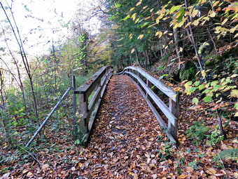
 At 11:00 AM I put my gear in the car and Sheila in the back seat and headed out Old Route 17 and drove across the Flats. I took Old Route 17 and Service Road to the point where they meet Fox Mountain Road. There were no vehicles in the parking lot which was surprising for such a beautiful day. We departed the parking area at 11:17 AM with the temperature at 44 degrees. The open trail just before the woods was damp but much drier than I thought it might be. It did show some signs of erosion. I checked the bushes that I had cut back and they remained well off the trail. We moved on toward the wooded part of the trail. In the shade the trail had a light covering of snow. We immediately ran into some mud pits but they had more water and mud than my previous trip. One look down to the Little Beaverkill showed the stream volume was well above average. I wondered about the condition of the falls and whether they would be as less interesting than my last trip. Sheila was taking her own route and following her nose and getting very close to the edge of the trail where a steep drop led down to the river! I continued picking up some newly fallen branches and throwing them off the trail. It was obvious the recent wind had brought down many branches and small trees. We crossed several muddy areas which were both long and wide. We were soon at the wooden walkways and I decided not to take any pictures until the return trip, if at all. We continued over the wooden walkways and ran into a small tree with a double trunk which had fallen across the bridge. There was no damage to the bridge but tools would be needed to remove the blowdown. The walkway and bridges were covered in a thin layer of snow made them very slippery. This time the water from the small stream was that flows off the roadway above was flowing in a channel it had cut in the far side of the bridge. The culvert under the bridge was completely blocked. After crossing the bridge, we ran into another large mud pit that had a layer of water with a few stepping stones. Just after this there was a very large and complex blowdown across the trail. Further inspection showed that there had been a mudslide which brought down soil and several large trees. The trees came down as the soil was eroded away exposing there roots. Fortunately, the largest trees had fallen into the hill instead of across the trail. I knew it would take an ax and saw and several hours of work to clear what had fallen across the trail. I took some pictures and we moved on.
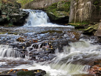
 As we approached the falls, I could hear the sound of the falls. We arrived at the falls and found that there was a huge flow of water. The volume was not quite as high as it is at some times in the spring. The water was somewhat muddy with a green tinge as it flowed over the falls to the basin below. The scene looked cold and bleak. Sheila and I worked our way down the frozen path to a narrow strip of land along the shore of the stream. I took some pictures downstream and across the stream to the other shore. I then started to take shots of the lower rapids and then the main falls. Sheila jumped up on some rocks so I took some pictures of her. We then worked our way back up the bank to the picnic table. I took some pictures of the falls from above and some more shots upstream. We moved on down the trail and I decided not to stop at the next bench. We started toward the Parksville end of the trail at an accelerated pace. We continued on to the end of the trail where we turned around at the sign detailing the hotels in Parksville. So far we had met no one else out for a walk and only the dogs near the end of the trail made a ruckus as we passed. We set a fast pace on the way back toward the parking area. We continued our accelerated pace as I hoped we could beat our time hiking out. We continued our pace passing the falls and working our way through the blowdown. As we approached the end of the trees, I looked at my watch and saw we were hiking a little faster than on the way out. As we broke out of the trees, I could see that my car was the only one in the lot. We arrived at the car at 1:37 PM meaning we had hiked a little les than 3.0 miles in 1 hour and 20 minutes. There is virtually no elevation gain on this short hike but carrying a pack and setting a fast pace helps with the exercise. My goal is to do this hike in 45 minutes without running. It also occurred to me that I could park in Parksville and hike toward Fox Mountain Road. I could then decide to continue the hike on the other side of Fox Mountain Road toward Old Liberty Road. This would allow me to get in a longer hike.
![]()
![]()
![]()
![]() On Saturday, December 16th I planned to get out for the first hike of the week. When I hiked last Saturday I was reminded of how great it makes me feel to get out. I planned to hike several day during the week and the sporting events and ambulance calls destroyed that plan. At noon I began to get ready with the temperature at 42 degrees on the back porch with plenty of bright sunshine. I decided to go across the street to Round Top to hike as I could get back quickly if I was needed on an ambulance call. As we began to get ready, Sheila was keeping a careful eye on me as I dressed as she would hike every day. Sheila often examines and sniffs my clothing to make sure I am serious about hiking. I decided to wear my Mammut long-sleeved crew shirt without a baselayer. This shirt is a little bit warmer and appropriate for the cooler weather. I wore my Railriders hiking pants which are expensive but last along time and have features like deep pockets and a generous cut which I really like. The pants have Velcro closures at the ankles. I decided to put on my new Keen Durand hiking boots which I ordered a half size larger than the previous pair. These shoes fit well out of the box but get much tighter when I add a decent insole. Without the third party insole, by feet hurt from the lack of support. I added a new pair of Xstance insoles in an effort to find the best support and cushioning for my feet. These insoles have shock absorbing gel pads, TPU arch support, and memory foam cushioning all wrapped in a breathable fabric. The insoles have been hyped by their manufacturer and they really do seem to deliver. I decided to take my Leki poles with external locks as the internal twist locks sometimes fail. I did decide to wear my Mammut hoody to block the breezy and keep me warm. It has pit zips that open all the way to the lower hem. I did put on a fleecy hat but eschewed gloves. I did bring along my phone in case there were any calls. At 12:25 PM we walked out the door to start the hike. I grabbed Sheila's leash from my car and put it on her as we walked up the driveway. I aimed to hike for about an hour and complete two figure 8's. Sheila was happy to get out as we headed down the driveway and across the street. We crossed the street and walked to the parking lot next to the Presbyterian Church. We walked to the back of the church and began the ascent of the steepest hill behind the church. The hill is short but gets the circulation pumping and is the steepest and longest climb on the "trail." We did not stop until we reached the top of the hill. At the top we paused for a minute so I could look around at the hills that surround the hamlet of Livingston Manor. I could still see some snow especially in the shade of the surrounding hills. The skies were clear with few clouds and plenty of sun. We continued the hike by turning left at the trailhead. The trail was covered in leaves and damp in a few places but there was no snow.
On Saturday, December 16th I planned to get out for the first hike of the week. When I hiked last Saturday I was reminded of how great it makes me feel to get out. I planned to hike several day during the week and the sporting events and ambulance calls destroyed that plan. At noon I began to get ready with the temperature at 42 degrees on the back porch with plenty of bright sunshine. I decided to go across the street to Round Top to hike as I could get back quickly if I was needed on an ambulance call. As we began to get ready, Sheila was keeping a careful eye on me as I dressed as she would hike every day. Sheila often examines and sniffs my clothing to make sure I am serious about hiking. I decided to wear my Mammut long-sleeved crew shirt without a baselayer. This shirt is a little bit warmer and appropriate for the cooler weather. I wore my Railriders hiking pants which are expensive but last along time and have features like deep pockets and a generous cut which I really like. The pants have Velcro closures at the ankles. I decided to put on my new Keen Durand hiking boots which I ordered a half size larger than the previous pair. These shoes fit well out of the box but get much tighter when I add a decent insole. Without the third party insole, by feet hurt from the lack of support. I added a new pair of Xstance insoles in an effort to find the best support and cushioning for my feet. These insoles have shock absorbing gel pads, TPU arch support, and memory foam cushioning all wrapped in a breathable fabric. The insoles have been hyped by their manufacturer and they really do seem to deliver. I decided to take my Leki poles with external locks as the internal twist locks sometimes fail. I did decide to wear my Mammut hoody to block the breezy and keep me warm. It has pit zips that open all the way to the lower hem. I did put on a fleecy hat but eschewed gloves. I did bring along my phone in case there were any calls. At 12:25 PM we walked out the door to start the hike. I grabbed Sheila's leash from my car and put it on her as we walked up the driveway. I aimed to hike for about an hour and complete two figure 8's. Sheila was happy to get out as we headed down the driveway and across the street. We crossed the street and walked to the parking lot next to the Presbyterian Church. We walked to the back of the church and began the ascent of the steepest hill behind the church. The hill is short but gets the circulation pumping and is the steepest and longest climb on the "trail." We did not stop until we reached the top of the hill. At the top we paused for a minute so I could look around at the hills that surround the hamlet of Livingston Manor. I could still see some snow especially in the shade of the surrounding hills. The skies were clear with few clouds and plenty of sun. We continued the hike by turning left at the trailhead. The trail was covered in leaves and damp in a few places but there was no snow.
We passed by all the places where I had cut trees to remove them from the trail. At the first trail junction, I followed Sheila as she turned right and started up the woods road which has the gentler approach of the two. There were many small branches on the trail from the winds that had passed through the area. I removed these branches either by dragging them off the trail or by using my poles on the smaller ones. It was a pleasure to walk on the trails and it was obvious more people were using them. We reached the end of the woods road and turned left up the hill on the trail. I could see the frame and tarps that covered the mouth of one of the "caves". They were looking like someone had cleaned up the area and might be using it again. We continued up the trail to the first trail junction with the upper blue trail where we turned left to follow the yellow trail along the base of Round Top. We continued on the yellow trail along the base of Round Top. We ran into one small tree across the trail and it was a little too big and secure for me to remove it without tools. The trail along the base of Round Top was covered in snow as it faces north and west. We came to the next junction with the blue trail and turned right to head up the blue trail toward the summit. This trail was also covered in snow but a little walking showed it was not going to be a problem to get a grip. When we got to the switchback, we turned right and followed it until it came back to the main blue trail. The fact that the switchback sidehills in places made the walk a little more difficult especially with the snow. We turned right and then continued straight ahead and up the hill toward the summit of Round Top bypassing the white crossover trail. As we walked over the high point, I removed a couple of branches from the trail. We continued over the summit and down the blue trail toward the junction with the yellow trail. On this side of the hill there was no snow on the trail. We bypassed the white crossover trail again and continued down to the yellow trail. At the junction with the yellow trail we turned right and walked the yellow trail along the base of Round Top to the next junction with the blue trail. Climbing over the blowdown was annoying and I debated going home to get a saw! We turned left and started slightly downhill toward the lookout over town. We passed the "sitting rock" and continued downhill through a sea of sad ferns which were completely brown.
When we reached the lookout, we followed the yellow trail as it turned left and descended the steep hill back to the first trail junction. We immediately turned around and started up the steep hill back to the viewpoint. We followed the yellow trail as it turned right and headed uphill toward the junction with the blue trail. We hiked up a short but steep little hill and arrived at the trail junction. We turned right to follow the trail along the base of Round Top. Sheila was some distance behind when she came roaring passed me at full speed. She passed me, made a 180 degree turn, and came running back. She repeated this several times before I called her off. We arrived at the next junction with the blue trail after climbing over the blowdown. We turned left to start the walk up the blue trail toward the summit. Sheila and I continued toward the summit again bypassing the white crossover trail. We continued over the summit which had a little anow. We started down the other side and turned left on the switchback in the blue trail. We followed the switchback out into the forest and then back to the main trail. We turned left and walked downhill to the yellow trail where a left turn again took us along the base of Round Top passing over the blowdown one last time. At the junction, Sheila and I turned right and walked down the trail to the woods road. We followed the woods road downhill with the ledges to the right. At the first trail junction, we turned left and walked straight out to the trailhead. We turned right and walked downhill and crossed the parking lot to the road. We waited to cross the road as several cars went by and then crossed to the driveway to the house. It was 1:35 PM and we had hiked a little over 2 miles and done some trail maintenance in 1 hour and 10 minutes.
![]()
![]()
![]()
![]() On Saturday, December 9th I knew I had to get in a hike after almost 3 weeks away from the woods! I had been sick but the biggest factor was the ambulance calls that had come in at every hour of the day and night. I had some work to do in the toning but by noon I was ready to go. Sheila could hardly contain her enthusiasm and was running around barking. I decided to take a short hike on Round Top just across the street as it was such a beautiful day. I knew I would have to carry my phone as I was the only EMT to respond on calls. I started to get ready at 12:30 PM with the temperature at 50 degrees on the back porch. I decided to wear my Mammut long-sleeved crew shirt without a baselayer. This shirt is a little bit warmer than some I have and I wondered if it would be warn enough to where alone. I wore my Railriders hiking pants which are expensive but last along time and have features like deep pockets and a generous cut which I really like. The pants have Velcro closures at the ankles. I decided to put on my Keen Durand hiking boots which I ordered a half size larger than the previous pair. These shoes fit well out of the box but get much tighter when I add a decent insole. Without the third party insole, by feet hurt from the lack of support. I added a new pair of Xstance insoles in an effort to find the best support and cushioning for my feet. These insoles have shock absorbing gel pads, TPU arch support, and memory foam cushioning all wrapped in a breathable fabric. I grabbed my Leki external lock poles which I have been using lately since twist locks have proved unreliable. I did don my Mammut hoody which has plenty of zippers to dump heat if needed. I did put on a fleecy orange hat but decided not to bother with gloves. At 12:45 PM we walked out the door to begin our hike. I grabbed Sheila's leash from my trunk as we walked up the driveway. We walked across the street and to the parking lot of the Presbyterian Church. We started off by walking behind the church to get to the road up the hill to the trailhead. Sheila and I began the ascent of the steepest hill behind the church. The hill is short but gets the circulation pumping and is the steepest and longest climb on the "trail." Sheila was setting a fast pace as we climbed the hill but I was having no trouble keeping up. My goal is always to make it all the way up the hill without stopping which I accomplished. I was a little surprised as I had not been out for so long! We stopped at the top of the hill so that we could take a look around at the scenery.
On Saturday, December 9th I knew I had to get in a hike after almost 3 weeks away from the woods! I had been sick but the biggest factor was the ambulance calls that had come in at every hour of the day and night. I had some work to do in the toning but by noon I was ready to go. Sheila could hardly contain her enthusiasm and was running around barking. I decided to take a short hike on Round Top just across the street as it was such a beautiful day. I knew I would have to carry my phone as I was the only EMT to respond on calls. I started to get ready at 12:30 PM with the temperature at 50 degrees on the back porch. I decided to wear my Mammut long-sleeved crew shirt without a baselayer. This shirt is a little bit warmer than some I have and I wondered if it would be warn enough to where alone. I wore my Railriders hiking pants which are expensive but last along time and have features like deep pockets and a generous cut which I really like. The pants have Velcro closures at the ankles. I decided to put on my Keen Durand hiking boots which I ordered a half size larger than the previous pair. These shoes fit well out of the box but get much tighter when I add a decent insole. Without the third party insole, by feet hurt from the lack of support. I added a new pair of Xstance insoles in an effort to find the best support and cushioning for my feet. These insoles have shock absorbing gel pads, TPU arch support, and memory foam cushioning all wrapped in a breathable fabric. I grabbed my Leki external lock poles which I have been using lately since twist locks have proved unreliable. I did don my Mammut hoody which has plenty of zippers to dump heat if needed. I did put on a fleecy orange hat but decided not to bother with gloves. At 12:45 PM we walked out the door to begin our hike. I grabbed Sheila's leash from my trunk as we walked up the driveway. We walked across the street and to the parking lot of the Presbyterian Church. We started off by walking behind the church to get to the road up the hill to the trailhead. Sheila and I began the ascent of the steepest hill behind the church. The hill is short but gets the circulation pumping and is the steepest and longest climb on the "trail." Sheila was setting a fast pace as we climbed the hill but I was having no trouble keeping up. My goal is always to make it all the way up the hill without stopping which I accomplished. I was a little surprised as I had not been out for so long! We stopped at the top of the hill so that we could take a look around at the scenery.
At the top of the hill we turned left and entered the woods to begin our hike. The skies were blue and sunny with a lot of puffy white clouds. The trail was slightly damp in some places with a little bit of mud. At the first trail junction, I followed Sheila as she continued straight ahead up the hill toward the lookout. The trail was well-worn as this is the most popular part of the hike. Some people simply hike up to the lookout over town and then back down. When we reached the top of the trail, I saw a solo male hiker starting down the hill toward us. I pulled Sheila over to the side of the trail and let him pass. We talked briefly about what a beautiful day we had for hiking. Sheila and I continued straight ahead passing the path to the lower lookout. I had tried blocking the trail with brush but people kept removing the obstacles. The problem is there is a growing chasm which could be difficult for some people to cross. At least the path is not marked as part of the trail system. We walked on the yellow trail as it headed uphill toward the next trail junction. As we walked up the trail, I removed a few loose branches from the trail. At one point there was a small tree across the trail but I was able to pick it up and throw it of the trail. We passed the "sitting rock" and continued on the yellow trail to the first junction with the blue trail. At the junction we turned right and walked on the yellow trail along the base of Round Top. At the next junction with the blue trail, we turned left and started up toward the summit. The trails were covered in leaves that had fallen from the trees and in some of the shaded places there was a thin layer of snow. We passed by the white crossover trail and walked oer the summit. We continued down the blue trail on the other side until we turned left on the switchback in the blue trail. We passed some more branches that I had cut and removed from the trail. The switchback took us out into the woods before turning almost 180 degrees to take us back to the main blue trail. We turned left and walked downhill to the yellow trail where we turned left again. We walked along the base of Round Top on the yellow trail. This time we turned right to head down the trail to the woods road. We continued to follow the yellow blazes back to the first trail junction.
I decided I wanted to do another figure 8 so Sheila and I turned around and walked back up the woods road. At the end of the woods road, we followed the yellow trail as the blazes turned up the hill toward the junction with the blue trail. As I looked to the left I saw that the "cave" under the rock ledges seemed to have a fresh blue canvas and another white covering to enclose the area. I am not sure this is legal on public land nor do I know the purpose. When we reached the junction with the blue trail, we turned left and walked the yellow trail along the base of Round Top. At the next junction, with the blue trail, we turned right and began to walk up the blue trail toward the summit. We turned right on the switchback and walked out into the woods and back. We turned right on the blue trail and headed toward the summit. We walked over the top and then headed down the other side passing the white crossover trail. We walked down the trail to the junction with the yellow trail where we turned right. We followed the yellow trail along the base of Round Top. At the next junction with the blue trail, we turned left and continued to follow the yellow trail downhill toward the lookout. We passed the "Sitting Rock" and soon came to the viewpoint. We followed the yellow trail as it turned left and started downhill to the first trail junction. When we reached the first junction, we continued straight ahead to the trailhead where I put Sheila on her leash. We turned right and walked down the road toward the parking lot of the Presbyterian Church. A small dachshund came running up from the house below. The owner was calling it but the dog showed no interested in behaving. The dog kept barking at Sheila who showed little interest. This has happened before and is very annoying! We were almost at the bottom of the hill when my phone sounded indicating an ambulance call. I responded and we quickened our pace. We continued down the hill and walked across Rock Avenue to our driveway. We were back at 1:50 PM after walking about two miles in 1 hour and 5 minutes which included the time needed to do some light trail maintenance. The temperature was still 50 degrees on the back porch. I quickly got ready to go on the call and drove down to the building.
![]()
![]()
![]()
![]() On Friday, November 17th I had not planned to go on a hike as I was not feeling well. I wanted to give myself a chance to recover from my first cold of the winter season which had come early. The pager went off early in the morning and we covered two calls which delayed my visit to my church. Around noon I headed to the church to prepare the music for the Sunday service. When I returned another call changed my further plans for the day. By 2:00 PM I was free and the temperature was 60 degrees. I decided I had to get out for a hike! I decided to take a short hike on Round Top just across the street as it was such a beautiful day. I knew I would have to carry my phone as I was the only EMT to respond on calls. I started to get ready at 2:15 PM with the temperature at 60 degrees on the back porch. I decided to wear my Mammut long-sleeved crew shirt without a baselayer. This shirt is a little bit warmer than some I have and I wondered if it would be warn enough to where alone. I wore my Railriders hiking pants which are expensive but last along time and have features like deep pockets and a generous cut which I really like. The pants have Velcro closures at the ankles. I decided to put on my new Keen Durand hiking boots which I ordered a half size larger than the previous pair. These shoes fit well out of the box but get much tighter when I add a decent insole. Without the third party insole, by feet hurt from the lack of support. I added a new pair of Xstance insoles in an effort to find the best support and cushioning for my feet. These insoles have shock absorbing gel pads, TPU arch support, and memory foam cushioning all wrapped in a breathable fabric. I grabbed my Leki external lock poles which I have been using lately since twist locks have proved unreliable. I did don my Mammut hoody which has plenty of zippers to dump heat if needed. I did not bother to wear a hat. At 2:25 PM we walked out the door to begin our hike. I grabbed Sheila's leash from my trunk as we walked up the driveway. We walked across the street and to the parking lot of the Presbyterian Church. We started off by walking behind the church to get to the road up the hill to the trailhead. Sheila and I began the ascent of the steepest hill behind the church. The hill is short but gets the circulation pumping and is the steepest and longest climb on the "trail." Sheila was setting a fast pace as we climbed the hill and I was having no trouble keeping up. My goal is always to make it all the way up the hill without stopping which I accomplished. We stopped at the top of the hill so that we could take a look around at the scenery.
On Friday, November 17th I had not planned to go on a hike as I was not feeling well. I wanted to give myself a chance to recover from my first cold of the winter season which had come early. The pager went off early in the morning and we covered two calls which delayed my visit to my church. Around noon I headed to the church to prepare the music for the Sunday service. When I returned another call changed my further plans for the day. By 2:00 PM I was free and the temperature was 60 degrees. I decided I had to get out for a hike! I decided to take a short hike on Round Top just across the street as it was such a beautiful day. I knew I would have to carry my phone as I was the only EMT to respond on calls. I started to get ready at 2:15 PM with the temperature at 60 degrees on the back porch. I decided to wear my Mammut long-sleeved crew shirt without a baselayer. This shirt is a little bit warmer than some I have and I wondered if it would be warn enough to where alone. I wore my Railriders hiking pants which are expensive but last along time and have features like deep pockets and a generous cut which I really like. The pants have Velcro closures at the ankles. I decided to put on my new Keen Durand hiking boots which I ordered a half size larger than the previous pair. These shoes fit well out of the box but get much tighter when I add a decent insole. Without the third party insole, by feet hurt from the lack of support. I added a new pair of Xstance insoles in an effort to find the best support and cushioning for my feet. These insoles have shock absorbing gel pads, TPU arch support, and memory foam cushioning all wrapped in a breathable fabric. I grabbed my Leki external lock poles which I have been using lately since twist locks have proved unreliable. I did don my Mammut hoody which has plenty of zippers to dump heat if needed. I did not bother to wear a hat. At 2:25 PM we walked out the door to begin our hike. I grabbed Sheila's leash from my trunk as we walked up the driveway. We walked across the street and to the parking lot of the Presbyterian Church. We started off by walking behind the church to get to the road up the hill to the trailhead. Sheila and I began the ascent of the steepest hill behind the church. The hill is short but gets the circulation pumping and is the steepest and longest climb on the "trail." Sheila was setting a fast pace as we climbed the hill and I was having no trouble keeping up. My goal is always to make it all the way up the hill without stopping which I accomplished. We stopped at the top of the hill so that we could take a look around at the scenery.
At the top of the hill we turned left and entered the woods to begin our hike. The skies were blue and sunny with a lot of puffy white clouds. The trail was slightly damp in some places with a little bit of mud. At the first trail junction, I followed Sheila as she continued straight ahead up the hill toward the lookout. The trail was well-worn as this is the most popular part of the hike. Some people simply hike up to the lookout over town and then back down. When we reached the top of the trail, we continued straight ahead passing the path to the lower lookout. I had tried blocking the trail with brush but people kept removing the obstacles. The problem is there is a growing chasm which could be difficult for some people to cross. At least the path is not marked as part of the trail system. We walked on the yellow trail as it headed uphill toward the next trail junction. As we walked up the trail, I removed a few loose branches from the trail. The trail was flanked by ferns with a thin path through them. The ferns were brown as the fall temperatures had been dropping into the 20's at night. We passed the "sitting rock" and continued on the yellow trail to the first junction with the blue trail. At the junction we turned right and walked on the yellow trail along the base of Round Top. At the next junction with the blue trail, we turned left and started up toward the summit. The trails were covered in leaves that had fallen from the trees where very few leaves still remained. We turned left on the white crossover trail and walked along the trail until it met the blue trail coming down from the summit. We turned left on the blue trail and almost immediately turned left on the switchback in the blue trail. We passed some more branches that I had cut and removed from the trail. The switchback took us out into the woods before turning almost 180 degrees to take us back to the main blue trail. We turned left and walked downhill to the yellow trail where we turned left again. We walked along the base of Round Top on the yellow trail. We turned right to head down the trail to the woods road. We continued to follow the yellow blazes back to the first trail junction.
I decided I wanted to do another figure 8 so Sheila and I turned around and walked back up the woods road. At the end of the woods road, we followed the yellow trail as the blazes turned up the hill toward the junction with the blue trail. When we reached this junction, we turned left and walked the yellow trail along the base of Round Top. At the next junction, with the blue trail, we turned right and began to walk up the blue trail toward the summit. We turned right on the switchback and walked out into the woods and back. We turned right on the blue trail and almost immediately turn right on the white crossover trail. We walked along the trail to the junction with the blue trail where we turned right. We walked down the blue trail to the yellow trail. We turned right on the yellow trail and again followed the yellow trail along the base of Round Top. At the next junction with the blue trail, we turned left and continued to follow the yellow trail downhill toward the lookout. We passed the "Sitting Rock" and soon came to the viewpoint. We followed the yellow trail as it turned left and started downhill to the first trail junction. When we reached the first junction, we continued straight ahead to the trailhead where I put Sheila on her leash. We turned right and walked down the road toward the parking lot of the Presbyterian Church. We continued down the hill and walked across Rock Avenue to our driveway. We were back at 3:30 PM after walking about two miles in 1 hour and 5 minutes which included the time needed to do some light trail maintenance. The temperature was now 58 degrees on the back porch.
![]()
![]()
![]()
![]()
![]() On Monday, November 13th I wanted to get out for a hike after taking a break on Sunday. At 6:30 M the temperature was 20 degrees on the back porch which was alright with me as I had some work to do. By noon the temperature had risen to 44 degrees and I began to get dressed to hike. Sheila was asleep on the couch and I decided not to wake her until I was ready to go. I decided I would go to the Parksville Rail Trail for a quick hike. The skies were blue with lots of sun and some nice white clouds even though the temperature was just over 40 degrees. The Parksville Rail Trail is about 2.5 miles out and back from the parking area near Fox Mountain Road with a beautiful waterfall. I decided to take my phone but leave it in the car so I could enjoy the hike. I decided to wear my Mammut long-sleeved crew shirt with a long-sleeved baselayer. This combination is a warmer than what I had been wearing and appropriate for the cooler weather. I wore a pair of Bauer First Ascent pants which are insulated against the cold and are slightly water repellant. I don't like the fit of these pants and have been looking for a replacement. I decided to put on my Keen Durand hiking boots which I ordered a half size larger than the previous pair. These shoes fit well out of the box but get much tighter when I add a decent insole. Without the third party insole, by feet hurt from the lack of support. I added a new pair of Xstance insoles in an effort to find the best support and cushioning for my feet. These insoles have shock absorbing gel pads, TPU arch support, and memory foam cushioning all wrapped in a breathable fabric. The insoles have been hyped by their manufacturer and they really do seem to deliver. I decided to take my Leki poles with external locks as the internal twist locks sometimes fail. I did decide to wear my Mammut hoody for warmth and to block the breeze. It has pit zips that open almost all the way to the lower hem. I donned a fleecy blaze orange hat and took along a pair of light knit gloves. I thought about putting on my OR Crocodile gaiters to deal with the mud that might be on the trail but in the end I left them home. I woke Sheila from her sleep and she immediately jumped down fem the couch, sniffed my clothing, and ran for the back door!
On Monday, November 13th I wanted to get out for a hike after taking a break on Sunday. At 6:30 M the temperature was 20 degrees on the back porch which was alright with me as I had some work to do. By noon the temperature had risen to 44 degrees and I began to get dressed to hike. Sheila was asleep on the couch and I decided not to wake her until I was ready to go. I decided I would go to the Parksville Rail Trail for a quick hike. The skies were blue with lots of sun and some nice white clouds even though the temperature was just over 40 degrees. The Parksville Rail Trail is about 2.5 miles out and back from the parking area near Fox Mountain Road with a beautiful waterfall. I decided to take my phone but leave it in the car so I could enjoy the hike. I decided to wear my Mammut long-sleeved crew shirt with a long-sleeved baselayer. This combination is a warmer than what I had been wearing and appropriate for the cooler weather. I wore a pair of Bauer First Ascent pants which are insulated against the cold and are slightly water repellant. I don't like the fit of these pants and have been looking for a replacement. I decided to put on my Keen Durand hiking boots which I ordered a half size larger than the previous pair. These shoes fit well out of the box but get much tighter when I add a decent insole. Without the third party insole, by feet hurt from the lack of support. I added a new pair of Xstance insoles in an effort to find the best support and cushioning for my feet. These insoles have shock absorbing gel pads, TPU arch support, and memory foam cushioning all wrapped in a breathable fabric. The insoles have been hyped by their manufacturer and they really do seem to deliver. I decided to take my Leki poles with external locks as the internal twist locks sometimes fail. I did decide to wear my Mammut hoody for warmth and to block the breeze. It has pit zips that open almost all the way to the lower hem. I donned a fleecy blaze orange hat and took along a pair of light knit gloves. I thought about putting on my OR Crocodile gaiters to deal with the mud that might be on the trail but in the end I left them home. I woke Sheila from her sleep and she immediately jumped down fem the couch, sniffed my clothing, and ran for the back door!
 At 12:45 PM I put my gear in the car and Sheila in the back seat and headed out Old Route 17 and drove across the Flats. I took Old Route 17 and Service Road to the point where they meet Fox Mountain Road. There were no vehicles in the parking lot which was surprising for such a beautiful day. We departed the parking area at 1:02 PM with the temperature at 44 degrees. The open trail just before the woods was dry but showed some erosion. I checked the bushes that I had cut back and they remained well off the trail. We moved on toward the wooded part of the trail. We immediately ran into some mud pits but they had less water and mud than our previous trip. One look down to the Little Beaverkill showed the stream volume was about average. I wondered about the condition of the falls and whether they would be as less interesting than my last trip. Sheila was taking her own route and following her nose and getting very close to the edge of the trail where a steep drop led down to the river! I continued picking up some newly fallen branches and throwing them off the trail. We crossed several muddy areas which were not as long or wide as they had been in some time. We were soon at the wooden walkways and I decided not to take any pictures until the return trip. We continued over the wooden walkways and bridges which were dry but covered in dirt ad leaves. I thought about bringing a rake and a broom next time to clean off the bridges which were covered in a mixture of leaves and dirt. This time the water from the small stream was treaty reduced and flowing around the bridge. After crossing the bridge, we ran into another large mud pit that had a layer of water with a few stepping stones.
 As we approached the falls, I could hear the sound of the falls. We arrived at the falls and found that there was a nice flow of water. The volume seemed lower than on our last trip. The water was mostly clear as it flowed over the falls to the basin below. I was hoping the scene would look cold but the sun was beginning to peek through. I decided to continue to the end of the trail and take pictures on the way back. We moved on down the trail and I decided not to stop at the next bench. We started toward the Parksville end of the trail at an accelerated pace. We continued on to the end of the trail where we turned around at the sign detailing the hotels in Parksville. So far we had met no one else out for a walk and the dogs near the end of the trail that usual raise a ruckus were silent. It was 1:27 PM meaning we had set a fast pace on the way out! I was determined to keep the fast pace on the way back toward the parking area. I decided not to take any pictures as the views were not much different than the last trip. We continued our accelerated pace as I hoped we could beat our time hiking out. We continued our pace passing the falls and then the bridge and walkway. As we approached the end of the trees, I looked at my watch and saw we were hiking a little faster than on the way out. As we broke out of the trees, I could see that my car was the only one in the lot. We arrived at the car at 1:51 PM so that the return hike took 24 minutes. We had hiked a little les than 3.0 miles in 49 minutes. There is virtually no elevation gain on this short hike but carrying a pack and setting a fast pace helps with the exercise. My goal is to do this hike in 45 minutes without running. It also occurred to me that I could park in Parksville and hike toward Fox Mountain Road. I could then decide to continue the hike on the other side of Fox Mountain Road toward Old Liberty Road. This would allow me to get in a longer hike.
![]()
![]()
![]()
![]() On Saturday, November 11th I awoke at 6:30 AM with the temperature at 23 degrees. I want to get out for a hike but found I was the only EMT available for most of the day. I also wanted to watch the live stream of the state cross country championships which ran from 9:00 AM to 2:30 PM. As I was watching the live stream, Kept waiting for an ambulance call but there were none. At 3:00 PM the temperature was up to 41 degrees but it was overcast and very raw outside. I almost decided to be lazy and stay home but realized I needed the exercise. I started to get ready as Sheila came over to sniff my clothing. She seemed very happy when she found I was putting on hiking clothes. I decided I would again go across the street to Round Top to hike as I could get back quickly if there was an ambulance call. I planned to do some loops rather than my usual figure 8's just for some variation. I decided to wear my Mammut long-sleeved crew shirt with a long-sleeved baselayer. This combination is a warmer than what I had been wearing and appropriate for the cooler weather. I wore a pair of Bauer First Ascent pants which are insulated against the cold and are slightly water repellant. I don't like the fit of these pants and have been looking for a replacement. I decided to put on my Keen Durand hiking boots which I ordered a half size larger than the previous pair. These shoes fit well out of the box but get much tighter when I add a decent insole. Without the third party insole, by feet hurt from the lack of support. I added a new pair of Xstance insoles in an effort to find the best support and cushioning for my feet. These insoles have shock absorbing gel pads, TPU arch support, and memory foam cushioning all wrapped in a breathable fabric. The insoles have been hyped by their manufacturer and they really do seem to deliver. I decided to take my Leki poles with external locks as the internal twist locks sometimes fail. I did decide to wear my Mammut hoody for warmth and to block the breeze. It has pit zips that open almost all the way to the lower hem. I did bring along my phone in case there were any calls. At 12:05 PM we walked out the door to start the hike. I grabbed Sheila's leash from my car and put it on her as we walked up the driveway. I aimed to hike for about an hour and complete two figure 8's. Sheila was happy to get out as we headed down the driveway and across the street. We crossed the street and walked to the parking lot next to the Presbyterian Church. We walked to the back of the church and began the ascent of the steepest hill behind the church. The hill is short but gets the circulation pumping and is the steepest and longest climb on the "trail." We did not stop until we reached the top of the hill. At the top we turned left at the trailhead. The trail was covered in leaves and damp in a few places.
On Saturday, November 11th I awoke at 6:30 AM with the temperature at 23 degrees. I want to get out for a hike but found I was the only EMT available for most of the day. I also wanted to watch the live stream of the state cross country championships which ran from 9:00 AM to 2:30 PM. As I was watching the live stream, Kept waiting for an ambulance call but there were none. At 3:00 PM the temperature was up to 41 degrees but it was overcast and very raw outside. I almost decided to be lazy and stay home but realized I needed the exercise. I started to get ready as Sheila came over to sniff my clothing. She seemed very happy when she found I was putting on hiking clothes. I decided I would again go across the street to Round Top to hike as I could get back quickly if there was an ambulance call. I planned to do some loops rather than my usual figure 8's just for some variation. I decided to wear my Mammut long-sleeved crew shirt with a long-sleeved baselayer. This combination is a warmer than what I had been wearing and appropriate for the cooler weather. I wore a pair of Bauer First Ascent pants which are insulated against the cold and are slightly water repellant. I don't like the fit of these pants and have been looking for a replacement. I decided to put on my Keen Durand hiking boots which I ordered a half size larger than the previous pair. These shoes fit well out of the box but get much tighter when I add a decent insole. Without the third party insole, by feet hurt from the lack of support. I added a new pair of Xstance insoles in an effort to find the best support and cushioning for my feet. These insoles have shock absorbing gel pads, TPU arch support, and memory foam cushioning all wrapped in a breathable fabric. The insoles have been hyped by their manufacturer and they really do seem to deliver. I decided to take my Leki poles with external locks as the internal twist locks sometimes fail. I did decide to wear my Mammut hoody for warmth and to block the breeze. It has pit zips that open almost all the way to the lower hem. I did bring along my phone in case there were any calls. At 12:05 PM we walked out the door to start the hike. I grabbed Sheila's leash from my car and put it on her as we walked up the driveway. I aimed to hike for about an hour and complete two figure 8's. Sheila was happy to get out as we headed down the driveway and across the street. We crossed the street and walked to the parking lot next to the Presbyterian Church. We walked to the back of the church and began the ascent of the steepest hill behind the church. The hill is short but gets the circulation pumping and is the steepest and longest climb on the "trail." We did not stop until we reached the top of the hill. At the top we turned left at the trailhead. The trail was covered in leaves and damp in a few places.
We passed by all the places where I had cut trees to remove them from the trail. At the first trail junction, I followed Sheila as she turned right and started up the woods road which has the gentler approach of the two. It was a pleasure to walk on the trails and it was obvious more people were using them. We reached the end of the woods road and turned left up the hill on the trail. I could see the frame and tarps that covered the mouth of one of the "caves". They were looking ragged as if no one had used them for some time. We continued up the trail to the first trail junction with the upper blue trail where continued straight ahead on the blue trail toward the summit. We walked uphill passing the white crossover trail. It seemed like a short walk over the summit before we started own the other side. We passed the white crossover trail. Instead of turning left on the switchback in the blue trail, we continued straight ahead on the blue trail. At the bottom of the hill we continued straight ahead on the yellow trail heading toward the viewpoint over town. We passed the "sitting rock" and continued downhill through a sea of ferns which were completely brown. When we reached the lookout, we followed the yellow trail as it turned left and descended the steep hill back to the first trail junction. I looked up and saw a woman hiking up the trail toward us. I grabbed Sheila and directed her off the trail so that the other hiker could pass. We walked down the hill to the first trail junction. We immediately turned around and started up the steep hill back to the viewpoint. We followed the yellow trail as it turned right and headed uphill toward the junction with the blue trail. We hiked up a short but steep little hill and arrived at the trail junction. We continued staright ahead on the blue trail toward the summit. When we came to the switchback, we simply walked passed it toward the summit. We also passed by the white crossover trail and passed over the summit. We continued on the blue trail down the hill passing the white crossover trail . At the junction with the yellow trail we continued straight ahead on the yellow trail. We headed down the yellow trail toward the woods road. We followed the yellow blazes as they took us slightly to the right on the yellow trail. It didn't take us long to return to the first trail junction. I checked my watch and after completing two big loops we were still short of an hour. We turned around and started back up the woods road. I was surprised that I felt very fresh and wished I was on a longer hike away from home! At the end of the woods road, we followed the yellow blazes as they turned left up the hill. When we arrived at the junction with the blue trail, we turned left to walk the yellow trail along the base of Round Top. This route allowed me to complete a short loop and check to see if there were any blowdowns on this part of the trail. The trail was in good shape and we were soon at the next junction with the blue trail. We turned left and continued on the yellow trail toward the lookout. This slight downhill walk went quickly. At the viewpoint we turned left and walked down the steeper hill to the first trail junction. We continued straight ahead to the trailhead where I put Sheila on her leash. We turned right and walked downhill without meeting any wandering dogs. We walked down the hill toward the church and crossed the parking lot to the road. We waited to cross the road as several cars went by and then crossed to the driveway to the house. It was 4:25 PM and we had hiked a little over 2 miles in 1 hour and 10 minutes. Sheila still seemed like she had a lot of energy. Once inside she began a set of zoomies through the living and dining rooms.
![]()
![]()
![]()
![]() On Wednesday, November 8th I wanted to get in a hike near home so that I could cover ambulance calls. I decided to take a short hike on Round Top just across the street as it was a beautiful day. I started to get ready at 12:15 PM with the temperature at 37 degrees on the back porch. I decided to wear my Mammut long-sleeved crew shirt with a long-sleeved baselayer. This shirt is a little bit warmer and appropriate for the cooler weather. I wore a pair of Bauer First Ascent pants which are insulated against the cold and are slightly water repellant. I don't like the fit of these pants and have been looking for a replacement. I decided to put on my new Keen Durand hiking boots which I ordered a half size larger than the previous pair. These shoes fit well out of the box but get much tighter when I add a decent insole. Without the third party insole, by feet hurt from the lack of support. I added a new pair of Xstance insoles in an effort to find the best support and cushioning for my feet. These insoles have shock absorbing gel pads, TPU arch support, and memory foam cushioning all wrapped in a breathable fabric. The insoles have been hyped by their manufacturer and they really do seem to deliver. I decided to take my Leki poles with external locks as the internal twist locks sometimes fail. I did don my Mammut hoody which has plenty of zippers to dump heat if needed. I also put on a light bright orange hat. I took my phone with me so that I could respond to ambulance calls if needed. At 12:35 we walked out the door to begin our hike. I grabbed Sheila's leash from my trunk as we walked up the driveway. We walked across the street and to the parking lot of the Presbyterian Church. We started off by walking behind the church to get to the road up the hill to the trailhead. Sheila and I began the ascent of the steepest hill behind the church. The hill is short but gets the circulation pumping and is the steepest and longest climb on the "trail." Sheila was setting a fast pace as we climbed the hill and I was having some trouble keeping up. My goal is always to make it all the way up the hill without stopping which I accomplished. We stopped at the top of the hill so that we could take a look around at the scenery. There was a large pickup truck parked blocking the road just beyond the trailhead. It always surprises me that people are so inconsiderate of others.
On Wednesday, November 8th I wanted to get in a hike near home so that I could cover ambulance calls. I decided to take a short hike on Round Top just across the street as it was a beautiful day. I started to get ready at 12:15 PM with the temperature at 37 degrees on the back porch. I decided to wear my Mammut long-sleeved crew shirt with a long-sleeved baselayer. This shirt is a little bit warmer and appropriate for the cooler weather. I wore a pair of Bauer First Ascent pants which are insulated against the cold and are slightly water repellant. I don't like the fit of these pants and have been looking for a replacement. I decided to put on my new Keen Durand hiking boots which I ordered a half size larger than the previous pair. These shoes fit well out of the box but get much tighter when I add a decent insole. Without the third party insole, by feet hurt from the lack of support. I added a new pair of Xstance insoles in an effort to find the best support and cushioning for my feet. These insoles have shock absorbing gel pads, TPU arch support, and memory foam cushioning all wrapped in a breathable fabric. The insoles have been hyped by their manufacturer and they really do seem to deliver. I decided to take my Leki poles with external locks as the internal twist locks sometimes fail. I did don my Mammut hoody which has plenty of zippers to dump heat if needed. I also put on a light bright orange hat. I took my phone with me so that I could respond to ambulance calls if needed. At 12:35 we walked out the door to begin our hike. I grabbed Sheila's leash from my trunk as we walked up the driveway. We walked across the street and to the parking lot of the Presbyterian Church. We started off by walking behind the church to get to the road up the hill to the trailhead. Sheila and I began the ascent of the steepest hill behind the church. The hill is short but gets the circulation pumping and is the steepest and longest climb on the "trail." Sheila was setting a fast pace as we climbed the hill and I was having some trouble keeping up. My goal is always to make it all the way up the hill without stopping which I accomplished. We stopped at the top of the hill so that we could take a look around at the scenery. There was a large pickup truck parked blocking the road just beyond the trailhead. It always surprises me that people are so inconsiderate of others.
At the top of the hill we turned left and entered the woods to begin our hike. The skies were blue with a lot of puffy white clouds. The trail was slightly damp in some places with a little bit of mud. At the first trail junction, I followed Sheila as she continued straight ahead up the hill toward the lookout. The trail was well-worn as this is the most popular part of the hike. Some people simply hike up to the lookout over town and then back down. When we reached the top of the trail, we continued straight ahead passing the path to the lower lookout. I had tried blocking the trail with brush but people kept removing the obstacles. The problem is there is a growing chasm which could be difficult for some people to cross. At least the path is not marked as part of the trail system. As we passed by the upper viewpoint, I could see a man standing on the lower lookout and assumed he was the owner of the illegal parked truck. We walked on the yellow trail as it headed uphill toward the next trail junction. As we walked up the trail, I removed a few loose branches from the trail. The trail was flanked by ferns with a thin path through them. The ferns were brown as the fall temperatures had been dropping into the 20's at night. We passed the "sitting rock" and continued on the yellow trail to the first junction with the blue trail. At the junction we turned right and walked on the yellow trail along the base of Round Top. At the next junction with the blue trail, we turned left and started up toward the summit. The trails were covered in leaves that had fallen from the trees where very few leaves still remained. We bypassed the white crossover trail and walked over the summit to start down the other side. We continued on the trail and again bypassed the white crossover trail but turned left on the switchback in the blue trail. We passed some more branches that I had cut and removed from the trail. The switchback took us out into the woods before turning almost 180 degrees to take us back to the main blue trail. We turned left and walked downhill to the yellow trail where we turned left again. We walked along the base of Round Top on the yellow trail. We turned right to head down the trail to the woods road. We continued to follow the yellow blazes back to the first trail junction.
I decided I wanted to do another figure 8 so Sheila and I turned around and walked back up the woods road. At the end of the woods road, we followed the yellow trail as the blazes turned up the hill toward the junction with the blue trail. When we reached this junction, we turned left and walked the yellow trail along the base of Round Top. At the next junction, with the blue trail, we turned right and began to walk up the blue trail toward the summit. We turned right on the switchback and walked out into the woods and back. We turned right on the blue trail and continued over the summit avoiding the white crossover trail. We walked over the summit and started down the other side toward the yellow trail. We contiued out to the main trail and turned right on the yellow trail. We turned right on the yellow trail and again followed the yellow trail along the base of Round Top. At the next junction with the blue trail, we turned left and continued to follow the yellow trail downhill toward the lookout. We passed the "Sitting Rock" and soon came to the viewpoint. We followed the yellow trail as it turned left and started downhill to the first trail junction. When we reached the first junction, we continued straight ahead to the trailhead where I put Sheila on her leash. We turned right and walked down the road toward the parking lot of the Presbyterian Church. The dog from a nearby house came running up the trail toward us followed by his owner. I knew the owner and we was declaring the dog was "OK". The dog did seem to want to play but I prefer dogs on leashes! After a brief conversation with the owner, who had controlled his dog, we continued down the hill. We walked across Rock Avenue to our driveway. We were back at 1:50 PM after walking about two miles in 1 hour and 15 minutes which included the time needed to do some light trail maintenance and to talk to the dog owner. The temperature was now 40 degrees on the back porch.
![]()
![]()
![]()
![]() On Monday, November 6th I planned to get out for a hike after more than a week off for bad weather and ambulance calls. At 11:45 AM I began to get ready with the temperature at 44 degrees on the back porch. I decided to go across the street to Round Top to hike as I could get back quickly if there was an ambulance call. As I began to get ready, Sheila was keeping a careful eye on me as I dressed. Sheila often examines and sniffs my clothing to make sure I am serious about hiking. I decided to wear my Mammut long-sleeved crew shirt with a long-sleeved baselayer. This combination is a warmer than what I had been wearing and appropriate for the cooler weather. I wore a pair of Bauer First Ascent pants which are insulated against the cold and are slightly water repellant. I don't like the fit of these pants and have been looking for a replacement. I decided to put on my Keen Durand hiking boots which I ordered a half size larger than the previous pair. These shoes fit well out of the box but get much tighter when I add a decent insole. Without the third party insole, by feet hurt from the lack of support. I added a new pair of Xstance insoles in an effort to find the best support and cushioning for my feet. These insoles have shock absorbing gel pads, TPU arch support, and memory foam cushioning all wrapped in a breathable fabric. The insoles have been hyped by their manufacturer and they really do seem to deliver. I decided to take my Leki poles with external locks as the internal twist locks sometimes fail. I did decide to wear my Mammut hoody for warmth and to block the breeE. It has pit zips that open almost all the way to the lower hem. I did bring along my phone in case there were any calls. At 12:05 PM we walked out the door to start the hike. I grabbed Sheila's leash from my car and put it on her as we walked up the driveway. I aimed to hike for about an hour and complete two figure 8's. Sheila was happy to get out as we headed down the driveway and across the street. We crossed the street and walked to the parking lot next to the Presbyterian Church. We walked to the back of the church and began the ascent of the steepest hill behind the church. The hill is short but gets the circulation pumping and is the steepest and longest climb on the "trail." We did not stop until we reached the top of the hill. At the top we paused for a minute so I could look around at the hills that surround the hamlet of Livingston Manor. The skies were cloudy but also had a generous expanse of blue. The trees all around us had dropped all of their leaves as had the ones on the hills around Livingston Mnaor. We continued the hike by turning left at the trailhead. The trail was covered in leaves and damp in a few places.
On Monday, November 6th I planned to get out for a hike after more than a week off for bad weather and ambulance calls. At 11:45 AM I began to get ready with the temperature at 44 degrees on the back porch. I decided to go across the street to Round Top to hike as I could get back quickly if there was an ambulance call. As I began to get ready, Sheila was keeping a careful eye on me as I dressed. Sheila often examines and sniffs my clothing to make sure I am serious about hiking. I decided to wear my Mammut long-sleeved crew shirt with a long-sleeved baselayer. This combination is a warmer than what I had been wearing and appropriate for the cooler weather. I wore a pair of Bauer First Ascent pants which are insulated against the cold and are slightly water repellant. I don't like the fit of these pants and have been looking for a replacement. I decided to put on my Keen Durand hiking boots which I ordered a half size larger than the previous pair. These shoes fit well out of the box but get much tighter when I add a decent insole. Without the third party insole, by feet hurt from the lack of support. I added a new pair of Xstance insoles in an effort to find the best support and cushioning for my feet. These insoles have shock absorbing gel pads, TPU arch support, and memory foam cushioning all wrapped in a breathable fabric. The insoles have been hyped by their manufacturer and they really do seem to deliver. I decided to take my Leki poles with external locks as the internal twist locks sometimes fail. I did decide to wear my Mammut hoody for warmth and to block the breeE. It has pit zips that open almost all the way to the lower hem. I did bring along my phone in case there were any calls. At 12:05 PM we walked out the door to start the hike. I grabbed Sheila's leash from my car and put it on her as we walked up the driveway. I aimed to hike for about an hour and complete two figure 8's. Sheila was happy to get out as we headed down the driveway and across the street. We crossed the street and walked to the parking lot next to the Presbyterian Church. We walked to the back of the church and began the ascent of the steepest hill behind the church. The hill is short but gets the circulation pumping and is the steepest and longest climb on the "trail." We did not stop until we reached the top of the hill. At the top we paused for a minute so I could look around at the hills that surround the hamlet of Livingston Manor. The skies were cloudy but also had a generous expanse of blue. The trees all around us had dropped all of their leaves as had the ones on the hills around Livingston Mnaor. We continued the hike by turning left at the trailhead. The trail was covered in leaves and damp in a few places.
We passed by all the places where I had cut trees to remove them from the trail. At the first trail junction, I followed Sheila as she turned right and started up the woods road which has the gentler approach of the two. There were a few branches on the trail from the winds that had passed through the area. I removed these branches either by dragging them off the trail or by using my poles on the smaller ones. It was a pleasure to walk on the trails and it was obvious more people were using them. We reached the end of the woods road and turned left up the hill on the trail. I could see the frame and tarps that covered the mouth of one of the "caves". They were looking ragged as if no one had used them for some time. We continued up the trail to the first trail junction with the upper blue trail where we turned left to follow the yellow trail along the base of Round Top. We continued on the yellow trail along the base of Round Top. The trail remained clear of any blowdowns and the brush was well back from the trail bed. We came to the next junction with the blue trail and turned right to head up the blue trail toward the summit. When we got to the switchback, we turned right and followed it until it came back to the main blue trail. The fact that the switchback sidehills in places made the walk a little more difficult. We turned right and then continued straight ahead and up the hill toward the summit of Round Top bypassing the white crossover trail. As we walked over the high point, I removed a couple of branches from the trail. We continued over the summit and down the blue trail toward the junction with the yellow trail. We bypassed the white crossover trail again and continued down to the yellow trail. At the junction with the yellow trail we turned right and walked the yellow trail along the base of Round Top to the next junction with the blue trail. This time we turned left and started slightly downhill toward the lookout over town. We passed the "sitting rock" and continued downhill through a sea of ferns which were completely brown.
When we reached the lookout, we followed the yellow trail as it turned left and descended the steep hill back to the first trail junction. It was 12:35 PM and it had taken exactly half an hour for the walk over and the first figure 8. We immediately turned around and started up the steep hill back to the viewpoint. We followed the yellow trail as it turned right and headed uphill toward the junction with the blue trail. We hiked up a short but steep little hill and arrived at the trail junction. We turned right to follow the trail along the base of Round Top. Sheila was some distance ahead when she came roaring back at me at full speed. She passed me, made a 180 degree turn, and came running back. She repeated this several times before I called her off. We arrived at the next junction with the blue trail and turned left to start the walk up the blue trail toward the summit. Sheila and I continued toward the summit again bypassing the white crossover trail. We continued over the summit which had a little mud. We started down the other side and turned left on the switchback in the blue trail. We followed the switchback out into the forest and then back to the main trail. We turned left and walked downhill to the yellow trail where a left turn again took us along the base of Round Top. At the junction, Sheila and I turned right and walked down the trail to the woods road. We followed the woods road downhill with the ledges to the right. At the first trail junction, we turned left and walked straight out to the trailhead. We turned right and walked downhill. A small dog started toward us yapping as it came. Sheila wanted to say hello but I guided her down the hill toward the church. We crossed the parking lot to the road. We waited to cross the road as several cars went by and then crossed to the driveway to the house. It was 1:05 PM and we had hiked a little over 2 miles and done some trail maintenance in 1 hour. Sheila still seemed like she had a lot of energy. Once inside she began a set of zoomies through the living and dining rooms.
![]()
![]()
![]()
![]() On Friday, October 27th I wanted to get out for a hike to extend my consecutive days with a hike or a bike. In the morning I went to my church to prepare the Sunday service and was surprised that there were no ambulance calls whole I was there. Most days we get multiple calls in our district or for mutual aid to other districts in the county. I was back by 1:00 PM and got some lunch. I asked Cindy if she would like to hike the Parksville Rail Trail from Fox Mountain Road to Old Liberty Road near Livingston Manor. She agreed and we began to get ready with the temperature at a ridiculous 78 degrees for the end of October. We started getting ready with the temperate at 82 degrees. I got dressed in my White Sierra light crew top and a short-sleeved compression baselayer. I wore my Railriders hiking pants which are expensive but last along time and have features like deep pockets and a generous cut which I really like. The pants have Velcro closures at the ankles. I decided to put on my new Keen Durand hiking boots which I ordered a half size larger than the previous pair. These shoes fit well out of the box but get much tighter when I add a decent insole. Without the third party insole, by feet hurt from the lack of support. I added a new pair of Xstance insoles in an effort to find the best support and cushioning for my feet. These insoles have shock absorbing gel pads, TPU arch support, and memory foam cushioning all wrapped in a breathable fabric. I grabbed my Leki external lock poles which I have been using lately since twist locks have proved unreliable. At 2:15 PM I put our gear in the car and Sheila in the back seat. I headed out Old Route 17 across the Flats and then took Old Route 17 and Service Road to the point where they meet Fox Mountain Road. Just after this intersection is the western parking area for the rail trail. The parking lot had no other cars parked which surprised me for such a nice day.
On Friday, October 27th I wanted to get out for a hike to extend my consecutive days with a hike or a bike. In the morning I went to my church to prepare the Sunday service and was surprised that there were no ambulance calls whole I was there. Most days we get multiple calls in our district or for mutual aid to other districts in the county. I was back by 1:00 PM and got some lunch. I asked Cindy if she would like to hike the Parksville Rail Trail from Fox Mountain Road to Old Liberty Road near Livingston Manor. She agreed and we began to get ready with the temperature at a ridiculous 78 degrees for the end of October. We started getting ready with the temperate at 82 degrees. I got dressed in my White Sierra light crew top and a short-sleeved compression baselayer. I wore my Railriders hiking pants which are expensive but last along time and have features like deep pockets and a generous cut which I really like. The pants have Velcro closures at the ankles. I decided to put on my new Keen Durand hiking boots which I ordered a half size larger than the previous pair. These shoes fit well out of the box but get much tighter when I add a decent insole. Without the third party insole, by feet hurt from the lack of support. I added a new pair of Xstance insoles in an effort to find the best support and cushioning for my feet. These insoles have shock absorbing gel pads, TPU arch support, and memory foam cushioning all wrapped in a breathable fabric. I grabbed my Leki external lock poles which I have been using lately since twist locks have proved unreliable. At 2:15 PM I put our gear in the car and Sheila in the back seat. I headed out Old Route 17 across the Flats and then took Old Route 17 and Service Road to the point where they meet Fox Mountain Road. Just after this intersection is the western parking area for the rail trail. The parking lot had no other cars parked which surprised me for such a nice day.
The temperature was still 76 degrees under blue skies with diffuse white clouds as we began the hike at 2:30 PM. We walked under the Quickway on Fox Mountain Road and crossed the bridge over a stream. We stepped over the guard rail and started out on the trail. Almost immediately we came to what was left of the trestle supports that carried the trail tracks over the stream. We started to walk up the trail to the left of the trestle and immediately came to a blowdown that I had trimmed so that hikers could easily get around it. I decided to come back and cut this with my axe at another time. We walked around the blowdown and up the trail to the top of the trestle. As we entered the shade of the trees, it immediately seemed a little cooler. The trail is rather well defined and stretches ahead for some distance. Like most rail trails it was very straight. Town of Liberty Supervisor Frank DeMayo had told me that this was state land and the town had an agreement from the state to use it during the summer. I saw no POSTED signs along the right-of-way. The hope is to connect the Parksville Rail Trail to all the sections that stretch as far as Livingston Manor. We started to walk along the trail and I noticed there was quite a bit of loud traffic on the Quickway! Between the traffic and the rustling of the leaves it was hard for Cindy and I to talk despite being a few feet part. We were both concerned about ticks but found a prevalence of deer keds! The land drops off steeply from the rail trail to the Little Beaverkill on the right. There was a surprisingly good volume of water in the stream despite the lack of rain for almost a week. On the left were some "cliffs" which were the result of the railroad cutting a path for the tracks. We continued to walk along the well-defined trail. It was a pleasant walk except for the many insects. There are two places along the trail where there were piles of garbage. It is hard to determine why they are there. Both piles had tarps over them which seemed to indicate someone once valued the items. Near the first pile on the right is a VW Bug down over the side of the trail! We soon came to the gate on the trail which is odd since it is state land. No one seems to know why the gate is there or who placed it. We walked around the gate and continued on the trail.
Soon we came to a small pond on the right with a red building behind it. The building looked to be in good shape but the windows were all boarded up. The grass on the trail had been mowed although I did not know who would do this. After hiking about 1.3 miles, we came to a driveway on the left which leads to the Sonoma Falls property. I knew this was private land and decided not to enter. I wish I could find out who owns the land and get explicit permission to walk around the property. It has been more than 12 years since I had last visited this area on a regular basis. At one time there was a campground on the property. Some local business people bought the property and built a cider mill and market. They took the time to construct some hiking trails along the stream. I remember that the falls were very nice with at least five separate drops which increased in height the farther upstream one ventured. We continued on the main trail toward Old Liberty Road and set a quick pace. The walk along the old road was interesting as there were some impressive rock cuts on the left. The waterway on the right had more water than I had seen there in some time. The walk was about .4 miles which was a little longer than I thought. When we arrived at Old Liberty Road, I saw that the trail actually continued straight ahead parallel to the road. I decided to explore this part of the trail on another visit. We turned around at 3:10 PM and walked back toward the car. We set a pretty fast pace on the way back and did not stop at all. There were a few photographic opportunities on the hike but we enjoyed the fast-paced walk. We were back at the car at 3:50 PM having hiked 3.4 miles in 1 hours and 20 minutes. The ascent was 230 feet but it is hardly noticeable as the trail feels flat when walking. I do hope the plans to connect the sections of the trails is successful!
![]()
![]()
![]()
![]()
![]() On Thursday, October 26th I wanted to get out for a hike after few days off for various commitments. At 8:30 AM, the ambulance pager sounded and I was off on a string of four different calls in our district! By the time I got home, I was pretty tired so I asked Cindy If she would like to eat at Caf� 43. She agreed so we met to eat. The food there is always great. We returned home by about 1:00 PM and I started to do some work. By 2:30 PM I could no longer resist the beautiful weather and started to get ready to hike. I decided I would go to the Parksville Rail Trail for a quick hike . The temperature was 78 degrees and the humidity was low with a slight breeze. The skies were blue with lots of sun and some nice white clouds. The Parksville Rail Trail is about 2.5 miles with a beautiful waterfall. I decided to take my phone just in case there was no other EMT around. As I was getting dressed it looked as if Sheila thought we might not hike again! I decided to wear my White Sierra long-sleeved crew shirt with a bight short-sleeved baselayer. This shirt islighter than many I wear and appropriate for the warmer weather. I wore my Railriders hiking pants which are expensive but last along time and have features like deep pockets and a generous cut which I really like. The pants have Velcro closures at the ankles. I decided to put on my new Keen Durand hiking boots which I ordered a half size larger than the previous pair. These shoes fit well out of the box but get much tighter when I add a decent insole. Without the third party insole, by feet hurt from the lack of support. I added a new pair of Xstance insoles in an effort to find the best support and cushioning for my feet. These insoles have shock absorbing gel pads, TPU arch support, and memory foam cushioning all wrapped in a breathable fabric. The insoles have been hyped by their manufacturer and they really do seem to deliver. I decided to take my Leki poles with external locks as the internal twist locks sometimes fail. I thought about putting on my OR Crocodile gaiters to deal with the mud that might be on the trail but in the end I left them home.
On Thursday, October 26th I wanted to get out for a hike after few days off for various commitments. At 8:30 AM, the ambulance pager sounded and I was off on a string of four different calls in our district! By the time I got home, I was pretty tired so I asked Cindy If she would like to eat at Caf� 43. She agreed so we met to eat. The food there is always great. We returned home by about 1:00 PM and I started to do some work. By 2:30 PM I could no longer resist the beautiful weather and started to get ready to hike. I decided I would go to the Parksville Rail Trail for a quick hike . The temperature was 78 degrees and the humidity was low with a slight breeze. The skies were blue with lots of sun and some nice white clouds. The Parksville Rail Trail is about 2.5 miles with a beautiful waterfall. I decided to take my phone just in case there was no other EMT around. As I was getting dressed it looked as if Sheila thought we might not hike again! I decided to wear my White Sierra long-sleeved crew shirt with a bight short-sleeved baselayer. This shirt islighter than many I wear and appropriate for the warmer weather. I wore my Railriders hiking pants which are expensive but last along time and have features like deep pockets and a generous cut which I really like. The pants have Velcro closures at the ankles. I decided to put on my new Keen Durand hiking boots which I ordered a half size larger than the previous pair. These shoes fit well out of the box but get much tighter when I add a decent insole. Without the third party insole, by feet hurt from the lack of support. I added a new pair of Xstance insoles in an effort to find the best support and cushioning for my feet. These insoles have shock absorbing gel pads, TPU arch support, and memory foam cushioning all wrapped in a breathable fabric. The insoles have been hyped by their manufacturer and they really do seem to deliver. I decided to take my Leki poles with external locks as the internal twist locks sometimes fail. I thought about putting on my OR Crocodile gaiters to deal with the mud that might be on the trail but in the end I left them home.
At 3:05 PM I put my gear in the car and Sheila in the back seat and headed out Old Route 17 and drove across the Flats. I took Old Route 17 and Service Road to the point where they meet Fox Mountain Road. There were no vehicles in the parking lot which was surprising for such a beautiful day. We departed the parking area at 3:20 PM with the temperature at 76 degrees. The open trail just before the woods was damp and showed some erosion. I checked the bushes that I had cut back and they remained well off the trail. We moved on toward the wooded part of the trail. We immediately ran into some mud pits with more water and mud than our last trip. One look down to the Little Beaverkill showed the stream volume was higher than I expected with a good volume of water. I wondered about the condition of the falls and whether they would be as more interesting than my last trip. Sheila was taking her own route and following her nose and getting very close to the edge of the trail where a steep drop led down to the river! I looked up and saw two women hiking in our direction with two dogs on leashes. I leashed Sheila as they approached. The women stepped off the trail so I continued passed the. When we came to where they were standing, I struck up a conversation. We let the dogs greet each other and all were well-behaved. We parted hiking in opposite directions. I continued picking up some newly fallen branches and throw them off the trail. We crossed several muddy areas which were not as long or wide as they had been in some time. We were soon at the wooden walkways and I decided not to take any pictures until the return trip. We continued over the wooden walkways and bridges which were dry but covered in dirt ad leaves. I thought about bringing a rake and a broom next time to clean off the bridges which were covered in a mixture of leaves and dirt. This time the water from the small stream was treaty reduced and flowing around the bridge. After crossing the bridge, we ran into another large mud pit that had a layer of water with a few stepping stones.
As we approached the falls, we could hear a loud sound which was the falls. We arrived at the falls and found that there was a nice flow of water. The volume seemed lower than on our last trip. The water was mostly clear as it flowed over the falls to the basin below. I decided to continue to the end of the trail and take pictures on the way back. We moved on down the trail and I decided not to stop at the next bench. We started toward the Parksville end of the trail at an accelerated pace. At this moment my phone went off altering me to an ambulance call. I was pretty far away from the car but knew that I might be the only EMT responding. I called the 911 enter to let them know I was responding and they informed me that we had a driver also. I hurried back toward the falls when the phone sounded again to et me know the call had been canceled. We turned around and continued on to the end of the trail where we turned around at the sign detailing the hotels in Parksville. It was 3:50 PM meaning we had set a fast pace despite the interruption! We set a fast pace back toward the parking area as I wanted to be ready for other call. I decided not to take any pictures as the views were not much different than the last trip. We continued our accelerated pace as I hoped we could beat our time hiking out. We continued our pace passing the falls and then the bridge and walkway. As we approached the end of the trees, I looked at my watch and saw we were hiking faster than on the way out. As we broke out of the trees, I could see that my car was the only one in the lot. We arrived at the car at 4:15 PM so that the return hike took 25 minutes. We had hiked about 3.0 miles in 55 minutes. There is virtually no elevation gain on the hike but carrying a pack helps with the exercise.
![]()
![]()
![]()
![]() On Wednesay, October 25th I planned to get out for a hike but knew I would have to stay close to home to cover ambulance calls. Lisa had contacted me about hiking figure 8's OM Round Top and we agreed to meet at 3L00 PM in the church parking lot. At 2:30 PM I began to get ready with the temperature at 70 degrees on the back porch. As I began to get ready, Sheila was keeping a careful eye on me as I dressed. Sheila often examines and sniffs our clothing to make sure I am serious about hiking. I decided to wear my White Sierra Mammut long-sleeved crew shirt without a baselayer. This shirt is a little bit lighter and appropriate for the warmer weather. I wore my Railriders hiking pants which are expensive but last along time and have features like deep pockets and a generous cut which I really like. The pants have Velcro closures at the ankles. I decided to put on my new Keen Durand hiking boots which I ordered a half size larger than the previous pair. These shoes fit well out of the box but get much tighter when I add a decent insole. Without the third party insole, by feet hurt from the lack of support. I added a new pair of Xstance insoles in an effort to find the best support and cushioning for my feet. These insoles have shock absorbing gel pads, TPU arch support, and memory foam cushioning all wrapped in a breathable fabric. The insoles have been hyped by their manufacturer and they really do seem to deliver. I decided to take my Leki poles with external locks as the internal twist locks sometimes fail. I decided I did not need a jacket or hat due to the unseasonably warm weather. I did bring along my phone in case there were any calls. At 2:55 PM we walked out the door to start the hike. I grabbed Sheila's leash from my car and put it on her as we walked up the driveway. I aimed to hike for about an hour and complete two figure 8's. Sheila was happy to get out as we headed down the driveway and across the street. We crossed the street and walked to the parking lot next to the Presbyterian Church. Lisa was waiting for us and as soon as Sheila saw her she began pulling on her leash. Sheila greeted Lisa who was almost ready to start the hike. We walked to the back of the church and began the ascent of the steepest hill behind the church. The hill is short but gets the circulation pumping and is the steepest and longest climb on the "trail." We did not stop until we reached the top of the hill. At the top we paused for a minute so we could look around at the hills that surround the hamlet of Livingston Manor. The skies were blue with white clouds. The trees all around us had dropped almost all of their leaves but their were still some of the beaches. We continued the hike by turning left at the trailhead. The trail was covered in leaves and damp in a few places.
On Wednesay, October 25th I planned to get out for a hike but knew I would have to stay close to home to cover ambulance calls. Lisa had contacted me about hiking figure 8's OM Round Top and we agreed to meet at 3L00 PM in the church parking lot. At 2:30 PM I began to get ready with the temperature at 70 degrees on the back porch. As I began to get ready, Sheila was keeping a careful eye on me as I dressed. Sheila often examines and sniffs our clothing to make sure I am serious about hiking. I decided to wear my White Sierra Mammut long-sleeved crew shirt without a baselayer. This shirt is a little bit lighter and appropriate for the warmer weather. I wore my Railriders hiking pants which are expensive but last along time and have features like deep pockets and a generous cut which I really like. The pants have Velcro closures at the ankles. I decided to put on my new Keen Durand hiking boots which I ordered a half size larger than the previous pair. These shoes fit well out of the box but get much tighter when I add a decent insole. Without the third party insole, by feet hurt from the lack of support. I added a new pair of Xstance insoles in an effort to find the best support and cushioning for my feet. These insoles have shock absorbing gel pads, TPU arch support, and memory foam cushioning all wrapped in a breathable fabric. The insoles have been hyped by their manufacturer and they really do seem to deliver. I decided to take my Leki poles with external locks as the internal twist locks sometimes fail. I decided I did not need a jacket or hat due to the unseasonably warm weather. I did bring along my phone in case there were any calls. At 2:55 PM we walked out the door to start the hike. I grabbed Sheila's leash from my car and put it on her as we walked up the driveway. I aimed to hike for about an hour and complete two figure 8's. Sheila was happy to get out as we headed down the driveway and across the street. We crossed the street and walked to the parking lot next to the Presbyterian Church. Lisa was waiting for us and as soon as Sheila saw her she began pulling on her leash. Sheila greeted Lisa who was almost ready to start the hike. We walked to the back of the church and began the ascent of the steepest hill behind the church. The hill is short but gets the circulation pumping and is the steepest and longest climb on the "trail." We did not stop until we reached the top of the hill. At the top we paused for a minute so we could look around at the hills that surround the hamlet of Livingston Manor. The skies were blue with white clouds. The trees all around us had dropped almost all of their leaves but their were still some of the beaches. We continued the hike by turning left at the trailhead. The trail was covered in leaves and damp in a few places.
We passed by all the places where I had cut trees to remove them from the trail and I pointed out to Lisa the work that can be done with hand tools. The trail was damp in some places but there was no mud. At the first trail junction, we followed Sheila as she continued straight ahead up the hill toward the lookout. The trail was well-worn as this is the most popular part of the hike. Some people simply hike up to the lookout over town and then back down. When we reached the top of the trail, we continued straight ahead passing the path to the lower lookout. I had tried blocking the trail with brush but people kept removing the obstacles. The problem is there is a growing chasm which could be difficult for some people to cross. At least the path is not marked as part of the trail system. We passed by the upper viewpoint as the views are blocked by several trees that have grown up. We walked on the yellow trail as it headed uphill toward the next trail junction. As we walked up the trail, we removed a few loose branches from the trail. The trail was flanked by ferns with a thin path through them. The ferns were brown as the fall temperatures had been dropping into the 30's at night. We passed the "sitting rock" and continued on the yellow trail to the first junction with the blue trail. At the junction we turned right and walked on the yellow trail along the base of Round Top. I made note that although I had cut back the brush there were still a few branches that were leaning in and needed to be lopped. At the next junction with the blue trail, we turned left and started up toward the summit. The trails were covered in leaves that had fallen from the trees where very few leaves still remained. We bypassed the white crossover trail and walked over the summit to start down the other side. We again bypassed the white crossover trail but turned left on the switchback in the blue trail. We passed some more branches that I had cut and removed from the trail. The switchback took us out into the woods before turning almost 180 degrees to take us back to the main blue trail. We turned left and walked downhill to the yellow trail where we turned left again. We walked along the base of Round Top on the yellow trail. This time when we reached the trail junction we turned right to head down the trail to the woods road. In several places it was clear that a large amount of water had washed over the trail cleaning away the leaves and pine needles. As we followed the yellow blazes back toward the first trail junction, my phone sounded to let me know there was an ambulance call. I knew there were no other EMTs available so I called in to the 911 center. Lisa knew what was going on and we greatly accelerated our pace. When we got back to the first trail junction, we turned left and walked quickly out to the trailhead. We turned right and moved swiftly down the hill. I grabbed a new orange bandana that was Lisa's present to Sheila and headed across the street. It wasn't a long hike but we covered a little over a mile in 35 minutes.
![]()
![]()
![]()
![]() On Saturday, October 21st I planned to get out for a hike if I could find someone to cover ambulance calls for an hour or so. I knew a driver would be available and found an EMT who would be around town. At noon I began to get ready with the temperature at 58 degrees on the back porch. I decided to go across the street to Round Top to hike as I could get back quickly if I was needed on a second call. As we began to get ready , Sheila was keeping a careful eye on me as I dressed. Sheila often examines and sniffs our clothing to make sure I am serious about hiking. I decided to wear my Mammut long-sleeved crew shirt without a baselayer. This shirt is a little bit warmer and appropriate for the cooler weather. I wore my Railriders hiking pants which are expensive but last along time and have features like deep pockets and a generous cut which I really like. The pants have Velcro closures at the ankles. I decided to put on my new Keen Durand hiking boots which I ordered a half size larger than the previous pair. These shoes fit well out of the box but get much tighter when I add a decent insole. Without the third party insole, by feet hurt from the lack of support. I added a new pair of Xstance insoles in an effort to find the best support and cushioning for my feet. These insoles have shock absorbing gel pads, TPU arch support, and memory foam cushioning all wrapped in a breathable fabric. The insoles have been hyped by their manufacturer and they really do seem to deliver. I decided to take my Leki poles with external locks as the internal twist locks sometimes fail. I did decide to wear my OR rain jacket to block the wind. It has pit zips that open all the way to the lower hem. I did bring along my phone in case there were any calls. At 12:20 PM we walked out the door to start the hike. I grabbed Sheila's leash from my car and put it on her as we walked up the driveway. I aimed to hike for about an hour and complete two figure 8's. Sheila was happy to get out as we headed down the driveway and across the street. We crossed the street and walked to the parking lot next to the Presbyterian Church. We walked to the back of the church and began the ascent of the steepest hill behind the church. The hill is short but gets the circulation pumping and is the steepest and longest climb on the "trail." We did not stop until we reached the top of the hill. At the top we paused for a minute so I could look around at the hills that surround the hamlet of Livingston Manor. The skies were overcast and it even looked like it might rain. The trees all around us had dropped almost all of their leaves but their were still some of the beaches. We continued the hike by turning left at the trailhead. The trail was covered in leaves and damp in a few places.
On Saturday, October 21st I planned to get out for a hike if I could find someone to cover ambulance calls for an hour or so. I knew a driver would be available and found an EMT who would be around town. At noon I began to get ready with the temperature at 58 degrees on the back porch. I decided to go across the street to Round Top to hike as I could get back quickly if I was needed on a second call. As we began to get ready , Sheila was keeping a careful eye on me as I dressed. Sheila often examines and sniffs our clothing to make sure I am serious about hiking. I decided to wear my Mammut long-sleeved crew shirt without a baselayer. This shirt is a little bit warmer and appropriate for the cooler weather. I wore my Railriders hiking pants which are expensive but last along time and have features like deep pockets and a generous cut which I really like. The pants have Velcro closures at the ankles. I decided to put on my new Keen Durand hiking boots which I ordered a half size larger than the previous pair. These shoes fit well out of the box but get much tighter when I add a decent insole. Without the third party insole, by feet hurt from the lack of support. I added a new pair of Xstance insoles in an effort to find the best support and cushioning for my feet. These insoles have shock absorbing gel pads, TPU arch support, and memory foam cushioning all wrapped in a breathable fabric. The insoles have been hyped by their manufacturer and they really do seem to deliver. I decided to take my Leki poles with external locks as the internal twist locks sometimes fail. I did decide to wear my OR rain jacket to block the wind. It has pit zips that open all the way to the lower hem. I did bring along my phone in case there were any calls. At 12:20 PM we walked out the door to start the hike. I grabbed Sheila's leash from my car and put it on her as we walked up the driveway. I aimed to hike for about an hour and complete two figure 8's. Sheila was happy to get out as we headed down the driveway and across the street. We crossed the street and walked to the parking lot next to the Presbyterian Church. We walked to the back of the church and began the ascent of the steepest hill behind the church. The hill is short but gets the circulation pumping and is the steepest and longest climb on the "trail." We did not stop until we reached the top of the hill. At the top we paused for a minute so I could look around at the hills that surround the hamlet of Livingston Manor. The skies were overcast and it even looked like it might rain. The trees all around us had dropped almost all of their leaves but their were still some of the beaches. We continued the hike by turning left at the trailhead. The trail was covered in leaves and damp in a few places.
We passed by all the places where I had cut trees to remove them from the trail. At the first trail junction, I followed Sheila as she turned right and started up the woods road which has the gentler approach of the two. There were a few branches on the trail from the winds that had passed through the area. I removed these branches either by dragging them off the trail or by using my poles on the smaller ones. It was a pleasure to walk on the trails and it was obvious more people were using them. We reached the end of the woods road and turned left up the hill on the trail. I could see the frame and tarps that covered the mouth of one of the "caves". They were looking ragged as if no one had used them for some time. We continued up the trail to the first trail junction with the upper blue trail where we turned left to follow the yellow trail along the base of Round Top. We continued on the yellow trail along the base of Round Top. We came to the next junction with the blue trail and turned right to head up the blue trail toward the summit. When we got to the switchback, we turned right and followed it until it came back to the main blue trail. The fact that the switchback sidehills in places made the walk a little more difficult. We turned right and then continued straight ahead and up the hill toward the summit of Round Top bypassing the white crossover trail. As we walked over the high point, I removed a couple of branches from the trail. We continued over the summit and down the blue trail toward the junction with the yellow trail. We bypassed the white crossover trail again and continued down to the yellow trail. At the junction with the yellow trail we turned right and walked the yellow trail along the base of Round Top to the next junction with the blue trail. We turned left and started slightly downhill toward the lookout over town. We passed the "sitting rock" and continued downhill through a sea of ferns which were almost completely brown.
When we reached the lookout, we followed the yellow trail as it turned left and descended the steep hill back to the first trail junction. We immediately turned around and started up the steep hill back to the viewpoint. We followed the yellow trail as it turned right and headed uphill toward the junction with the blue trail. We hiked up a short but steep little hill and arrived at the trail junction. We turned right to follow the trail along the base of Round Top. Sheila was some distance ahead when she came roaring back at me at full speed. She passed me, made a 180 degree turn, and came running back. She repeated this several times before I called her off. We arrived at the next junction with the blue trail and turned left to start the walk up the blue trail toward the summit. Sheila and I continued toward the summit again bypassing the white crossover trail. We continued over the summit which had a little mud. We started down the other side and turned left on the switchback in the blue trail. We followed the switchback out into the forest and then back to the main trail. We turned left and walked downhill to the yellow trail where a left turn again took us along the base of Round Top. At the junction, Sheila and I turned right and walked down the trail to the woods road. We followed the woods road downhill with the ledges to the right. On the way we met two hikers waling up from the woods road toward us. We greeted each other and continued to walk in opposite directions. At the first trail junction, we turned left and walked straight out to the trailhead. We turned right and walked downhill and crossed the parking lot to the road. We waited to cross the road as several cars went by and then crossed to the driveway to the house. It was 1:35 PM and we had hiked a little over 2 miles and done some trail maintenance in 1 hour and 15 minutes.
![]()
![]()
![]()
![]() On Tuesday, October 17th I wanted to get in a hike near home before timing a soccer game in the afternoon. I decided to take a short hike on Round Top just across the street as it was a beautiful day. I started to get ready at 12:30 PM with the temperature at 56 degrees on the back porch. I decided to wear my Mammut long-sleeved crew shirt without a baselayer. This shirt is a little bit warmer and appropriate for the cooler weather. I wore my Railriders hiking pants which are expensive but last along time and have features like deep pockets and a generous cut which I really like. The pants have Velcro closures at the ankles. I decided to put on my new Keen Durand hiking boots which I ordered a half size larger than the previous pair. These shoes fit well out of the box but get much tighter when I add a decent insole. Without the third party insole, by feet hurt from the lack of support. I added a new pair of Xstance insoles in an effort to find the best support and cushioning for my feet. These insoles have shock absorbing gel pads, TPU arch support, and memory foam cushioning all wrapped in a breathable fabric. The insoles have been hyped by their manufacturer and they really do seem to deliver. I decided to take my Leki poles with external locks as the internal twist locks sometimes fail. I did don my Mammut hoody which has plenty of zippers to dump heat if needed. I also put on a light hat. I left my phone at home so that I could enjoy the hike without going on an ambulance call! I grabbed Sheila's leash from my trunk as we walked up the driveway at 12:45 PM. We walked across the street and to the parking lot of the Presbyterian Church. We started off by walking behind the church to get to the road up the hill to the trailhead. I saw a man walking down the hill with two dogs on a leash. As they disappeared, I saw a car pull into the parking area. A man got out of the car to ask me the location of the trailhead for Round Top. I told him the church probably would not mind if he parked in the lot and hiked up the hill to the trails. Sheila and I began the ascent of the steepest hill behind the church. The hill is short but gets the circulation pumping and is the steepest and longest climb on the "trail." Sheila was setting a fast pace as we climbed the hill and I was having some trouble keeping up. My goal is always to make it all the way up the hill without stopping which I accomplished. We stopped at the top of the hill so that we could take a look around at the scenery.
On Tuesday, October 17th I wanted to get in a hike near home before timing a soccer game in the afternoon. I decided to take a short hike on Round Top just across the street as it was a beautiful day. I started to get ready at 12:30 PM with the temperature at 56 degrees on the back porch. I decided to wear my Mammut long-sleeved crew shirt without a baselayer. This shirt is a little bit warmer and appropriate for the cooler weather. I wore my Railriders hiking pants which are expensive but last along time and have features like deep pockets and a generous cut which I really like. The pants have Velcro closures at the ankles. I decided to put on my new Keen Durand hiking boots which I ordered a half size larger than the previous pair. These shoes fit well out of the box but get much tighter when I add a decent insole. Without the third party insole, by feet hurt from the lack of support. I added a new pair of Xstance insoles in an effort to find the best support and cushioning for my feet. These insoles have shock absorbing gel pads, TPU arch support, and memory foam cushioning all wrapped in a breathable fabric. The insoles have been hyped by their manufacturer and they really do seem to deliver. I decided to take my Leki poles with external locks as the internal twist locks sometimes fail. I did don my Mammut hoody which has plenty of zippers to dump heat if needed. I also put on a light hat. I left my phone at home so that I could enjoy the hike without going on an ambulance call! I grabbed Sheila's leash from my trunk as we walked up the driveway at 12:45 PM. We walked across the street and to the parking lot of the Presbyterian Church. We started off by walking behind the church to get to the road up the hill to the trailhead. I saw a man walking down the hill with two dogs on a leash. As they disappeared, I saw a car pull into the parking area. A man got out of the car to ask me the location of the trailhead for Round Top. I told him the church probably would not mind if he parked in the lot and hiked up the hill to the trails. Sheila and I began the ascent of the steepest hill behind the church. The hill is short but gets the circulation pumping and is the steepest and longest climb on the "trail." Sheila was setting a fast pace as we climbed the hill and I was having some trouble keeping up. My goal is always to make it all the way up the hill without stopping which I accomplished. We stopped at the top of the hill so that we could take a look around at the scenery.
At the top of the hill we turned left and entered the woods to begin our hike. I could immediately feel that the temperature had dropped several degrees because of the shade and a slight breeze. The skies were blue with puffy white clouds. The trail was damp in some places but there was no mud. At the first trail junction, I followed Sheila as she continued straight ahead up the hill toward the lookout. The trail was well-worn as this is the most popular part of the hike. Some people simply hike up to the lookout over town and then back down. When we reached the top of the trail, we continued straight ahead passing the path to the lower lookout. I had tried blocking the trail with brush but people kept removing the obstacles. The problem is there is a growing chasm which could be difficult for some people to cross. At least the path is not marked as part of the trail system. We passed by the upper viewpoint as the views are blocked by several trees that have grown up. We walked on the yellow trail as it headed uphill toward the next trail junction. As we walked up the trail, we removed a few loose branches from the trail. The trail was flanked by ferns with a thin path through them. The ferns were brown as the fall temperatures had been dropping into the 30's at night. We passed the "sitting rock" and continued on the yellow trail to the first junction with the blue trail. At the junction we turned right and walked on the yellow trail along the base of Round Top. I made note that although I had cut back the brush there were still a few branches that were leaning in and needed to be lopped. At the next junction with the blue trail, we turned left and started up toward the summit. The trails were covered in leaves that had fallen from the trees where very few leaves still remained. We bypassed the white crossover trail and walked over the summit to start down the other side. I looked up to see the couple that had been in the car hiking up the hill toward us. We stopped to talk and Sheila seemed not to care that there were other people on her trails. The couple was from Syracuse and was hoping Round Top would be a longer hike. I talked to them about hiking at Frick and Hodge Ponds. I also mentioned the short but Beautiful hike to Mongaup Falls. We soon continued in opposite directions. We again bypassed the white crossover trail but turned left on the switchback in the blue trail. We passed some more branches that I had cut and removed from the trail. The switchback took us out into the woods before turning almost 180 degrees to take us back to the main blue trail. We turned left and walked downhill to the yellow trail where we turned left again. We walked along the base of Round Top on the yellow trail. This time when we reached the trail junction the couple were just coming down from the summit of Round Top. We let them go ahead of us but stayed with them to talk. we turned right to head down the trail to the woods road. In several places it was clear that a large amount of water had washed over the trail cleaning away the leaves and pine needles. We continued to follow the yellow blazes back to the first trail junction. The couple turned left continued out to the trailhead.
I decided I wanted to do another figure 8 so Sheila and I turned around and walked back up the woods road. At the end of the woods road, we followed the yellow trail as the blazes turned up the hill toward the junction with the blue trail. When we reached this junction, we turned left and walked the yellow trail along the base of Round Top. At the next junction, with the blue trail, we turned right and began to walk up the blue trail toward the summit. We turned right on the switchback and walked out into the woods and back. We turned right on the blue trail and continued over the summit avoiding the white crossover trail. We walked over the summit and started down the other side toward the yellow trail. We contiued out to the main trail and turned right on the yellow trail. We turned right on the yellow trail and again followed the yellow trail along the base of Round Top. At the next junction with the blue trail, we turned left and continued to follow the yellow trail downhill toward the lookout. We passed the "Sitting Rock" and soon came to the viewpoint. We followed the yellow trail as it turned left and started downhill to the first trail junction. When we reached the first junction, we continued straight ahead to the trailhead where we turned right and walked down the road to the parking lot of the Presbyterian Church. I put Sheila back on her leash to cross the street. We walked across Rock Avenue to our driveway. We were back at 2:00 PM after walking about two miles in 1 hour and 15 minutes which included the time needed to do some light trail maintenance and to talk to the other hikers. The temperature was now 58 degrees and the skies were beginning to darken.
![]()
![]()
![]()
![]()
![]() On Thursday, October 12th I wanted to get out for a hike after few days off for ambulance calls, bad weather and soccer ganes; not necessarily in that order. I wondered if we would see any color still in the trees and if any waterfalls would be roaring from the recent rain. I decided I would go to the Parksville Rail Trail for a quick hike as I wanted to see what the recent heavy rain had done to the volume of the stream and the falls. I asked Cindy if she would like to go along but she declines. The temperature was 66 degrees and the humidity was low with a slight breeze. The skies were blue with some sun and some nice white clouds. I started to get ready at 12:00 PM with Sheila keeping a watchful eye on me. The Parksville Rail Trail is about 2.5 miles with a beautiful waterfall. I decided to leave my pager and phone home as I knew others were around to respond and I needed a break. As I was getting dressed it looked as if Sheila thought we might not hike again! I decided to wear my Mammut long-sleeved crew shirt without a baselayer. This shirt is a little bit warmer and appropriate for the cooler weather. I wore my Railriders hiking pants which are expensive but last along time and have features like deep pockets and a generous cut which I really like. The pants have Velcro closures at the ankles. I decided to put on my new Keen Durand hiking boots which I ordered a half size larger than the previous pair. These shoes fit well out of the box but get much tighter when I add a decent insole. Without the third party insole, by feet hurt from the lack of support. I added a new pair of Xstance insoles in an effort to find the best support and cushioning for my feet. These insoles have shock absorbing gel pads, TPU arch support, and memory foam cushioning all wrapped in a breathable fabric. The insoles have been hyped by their manufacturer and they really do seem to deliver. I decided to take my Leki poles with external locks as the internal twist locks sometimes fail. I thought about putting on my OR Crocodile gaiters to deal with the mud that might be on the trail but in the end I forgot them. I thought about a jacket, hat, and gloves but decided there would be plenty of time for them. I did slip my Silky Sugowaza saw into my pack.
On Thursday, October 12th I wanted to get out for a hike after few days off for ambulance calls, bad weather and soccer ganes; not necessarily in that order. I wondered if we would see any color still in the trees and if any waterfalls would be roaring from the recent rain. I decided I would go to the Parksville Rail Trail for a quick hike as I wanted to see what the recent heavy rain had done to the volume of the stream and the falls. I asked Cindy if she would like to go along but she declines. The temperature was 66 degrees and the humidity was low with a slight breeze. The skies were blue with some sun and some nice white clouds. I started to get ready at 12:00 PM with Sheila keeping a watchful eye on me. The Parksville Rail Trail is about 2.5 miles with a beautiful waterfall. I decided to leave my pager and phone home as I knew others were around to respond and I needed a break. As I was getting dressed it looked as if Sheila thought we might not hike again! I decided to wear my Mammut long-sleeved crew shirt without a baselayer. This shirt is a little bit warmer and appropriate for the cooler weather. I wore my Railriders hiking pants which are expensive but last along time and have features like deep pockets and a generous cut which I really like. The pants have Velcro closures at the ankles. I decided to put on my new Keen Durand hiking boots which I ordered a half size larger than the previous pair. These shoes fit well out of the box but get much tighter when I add a decent insole. Without the third party insole, by feet hurt from the lack of support. I added a new pair of Xstance insoles in an effort to find the best support and cushioning for my feet. These insoles have shock absorbing gel pads, TPU arch support, and memory foam cushioning all wrapped in a breathable fabric. The insoles have been hyped by their manufacturer and they really do seem to deliver. I decided to take my Leki poles with external locks as the internal twist locks sometimes fail. I thought about putting on my OR Crocodile gaiters to deal with the mud that might be on the trail but in the end I forgot them. I thought about a jacket, hat, and gloves but decided there would be plenty of time for them. I did slip my Silky Sugowaza saw into my pack.
At 12:25 PM I put my gear in the car and Sheila in the back seat and headed out Old Route 17 and drove across the Flats. I took Old Route 17 and Service Road to the point where they meet Fox Mountain Road. There were one vehicle in the parking lot which was surprising for such a beautiful day. We departed the parking area at 12:40 PM with the temperature at 66 degrees. The open trail just before the woods was damp and showed some erosion from the steady rain that had occurred lately. I checked the bushes that I had cut back and they remained well off the trail. We moved on toward the wooded part of the trail. We immediately ran into some mud pits with more water and mud than our last trip. One look down to the Little Beaverkill showed the stream volume was higher than I expected with a good volume of water. I wondered about the condition of the falls and whether they would be as more interesting than my last trip. Sheila was taking her own route and following her nose and getting very close to the edge of the trail where a steep drop led down to the river! We began to run into some branches hanging into the trail from the side and above. I continued picking up some newly fallen branches and throw them off the trail. Along the way I looked up to see a couple walking toward us with their dog on a leash. I put Sheila on her leash and we passed by each other with a "hello". We crossed several muddy areas which were longer and wider than they had been in some times but we were soon at the wooden walkways. I decided to take some pictures of the stream and sky from the viewpoint even though I have many such shots. This time the light was not the best but the color of the trees offered a nice contrast to the blue sky. We continued over the wooden walkways and bridges which were wet and muddy from the rain. I thought about bringing a rake and a broom next time to clean off the bridges which were covered in a mixture of wet leaves and mud. This time the water from the small stream was eroding deep channels on the near and far sides of the bridge rather than flowing through the culvert under the bridge. After crossing the bridge, we ran into another large mud pit that had a layer of water with a few stepping stones. We came to one medium sized trunk blocking the left side of the trail. I got out the saw and sliced the trunk near the edge of the trail. The piece I cut was a little heavier than I thought but I got it to the side of the trail. When I was finished, we moved on to the next trunk which was longer but smaller in diameter. I intended to make two cuts on this longer trunk. I made the first cut just off the trail on the left side. I moved to the other side of the trail and cut through a larger diameter section. It looked like the base of the tree might have some spring in it. As I finished the cut the base section sprang up just missing my face! I moved the section off the trail and we moved on.
As we approached the falls, we could hear a loud sound which was the falls. We arrived at the falls and found that there was a nice flow of water. The volume seemed lower than the highest we had seen but it was well above anything we had seen during the summer amd fall. The water was mostly clear as it flowed over the falls to the basin below. I decided to go down to the streambed to take pictures even though I have quite a few pictures from the base of the falls. I took my pack and poles with me as Sheila and I headed down the bank to the stream. I put my pack down by the stream and took out my camera. I took some shots downstream where the light was illuminating the stream and the surrounding banks. I then turned my attention to the falls. I took some shots of the upper falls and lower rapids. After the wide-angle pictures, I took some close-ups of both falls. Sheila posed on a rock amd I took some pictures of her with the falls in the background. When I finished, we climbed back up the bank. I took some shots of the falls from above from different locations and different angles. I also took picture upstream from this higher angle. I could see that the path along the edge of the stream was almost completely covered with water. We moved on down the trail and I decided not to stop at the next bench. We started toward the Parksville end of the trail at an accelerated pace. We continued on to the end of the trail where we turned around at the sign detailing the hotels in Parksville. As we turned, I saw a lone hiker headed toward us in black pants, black jacket, white shirt, and black cap. It was 1:25 PM and we set a fast pace back toward the parking area as I wanted to stay in front of the hiker behind us. I didn't think much about the other hiker until I heard a voice behind us. The hiker had caught up to us and wanted to make sure Sheila would not bother him. I took Sheila by the collar and stepped off the trail as the hiker blew by us. We continued our accelerated pace but the other hiker easily pulled away from us and disappeared. We continued our pace passing the falls and then the bridge and walkway. As we approached the end of the trees, we met the other hiker coming back toward us. I asked him if he had walked the other part of the trail toward Livingston Manor. He said that he had not but would try it. As we broke out of the trees, I could see that my car was the only one in the lot. We arrived at the car at 2:00 PM after hiking about 3.0 miles in 1 hour and 20 minutes. There is virtually no elevation gain on the hike but carrying a pack helps with the exercise.
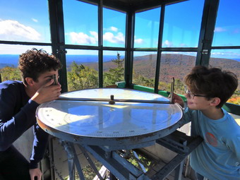
![]()
![]()
![]()
![]()
![]() On Monday, October 9th, I wanted to get out for a hike which was a little harder than I had been doing. I also wanted to get in some elevation gain to see the fall colors from above. My son Karl and I talked about hiking with his whole family to the Red Hill fire tower from the newer trailhead on Denning Road. The trailhead on Dinch-Coons Road is difficult to access in the winter as the road is not cleared and it is equally difficult when it is muddy. Many people park at the top of the hill where there is limited parking. It is a half mile downhill to the trailhead parking lot. The return trip can be nearly impossible if there is ice, packed snow or mud on the road. The new trailhead and parking area is on Denning Road 1.7 miles from the Claryville Post Office. We decided on Friday to meet at 9:00 AM at the parking lot on Denning Road. I knew there was a detour for bridge repair but hoped it was after the parking area. Sunday night into Monday morning we had several ambulance calls so I got very little sleep. A call came in at 7:18 AM which I thought would put an end to my hiking plans but the call was canceled and I decided I wanted to go. At 7:30 AM when I was starting to get ready the temperature was 34 degrees. I hoped it would warm up but also knew the temperature at the trailhead might be lower. As I began to get ready Sheila was keeping a close watch on my movements. I put on my Mammut long-sleeved crew top with a long-sleeved baselayer since the temperature was cool. I wore a pair of Bauer First Ascent pants which are insulated against the cold and are slightly water repellant. I don't like the fit of these pants and have been looking for a replacement. I decided to put on my a pair of Keen Durand hiking boots to which I had added a set of Protalus insoles to replace the ones Keen uses. It is a shame that most high end hiking boot manufacturers include insoles without proper support. Without the third party insole, by feet hurt from the lack of support. I grabbed my Leki external lock poles which I have been using since the spring since twist locks have proved unreliable. I also donned my Mammut hoody which was enough zippers to dump heat when needed. I put on an orange hat and wore a light pair of gloves. I also put on my OR Crocodile gaiters which come almost to my knee to deal with the mud and to keep my lower legs warm. I put my gear in the back of the car and Sheila in the back seat and we left Livingston Manor at 11:15 AM. I headed out the DeBruce Road passing through DeBruce and Willowemoc. At the end of the road I turned right on Route 47 and drove out to the Denning Road. Here I turned left and drove through Claryville. I drove 1.7 miles from the Claryville Post Office, we came to the new parking area on the right side of the road and pulled into the lot. There is a sign hanging from the support on the side of the road to designate the parking area and a kiosk with a description and maps. I was glad I had not run into the detour which is beyond the parking aea on Denning Road. I was also glad that Karl and his family were waiting for me in the lot. Their car was parked in the lot next to a red pickup truck. As I got out of the car, the whole family greeted me and it was obvious they were ready to hike. Karl mentioned that the truck belonged to Doug Hamilton, a tower guide, who had gone on ahead to open the tower cab and observer's cabin. I let Sheila out of the car and she was very happy to see everyone. We walked to the back of the parking area and started up the trail at 9:05 AM with the temperature standing at 34 degrees.
On Monday, October 9th, I wanted to get out for a hike which was a little harder than I had been doing. I also wanted to get in some elevation gain to see the fall colors from above. My son Karl and I talked about hiking with his whole family to the Red Hill fire tower from the newer trailhead on Denning Road. The trailhead on Dinch-Coons Road is difficult to access in the winter as the road is not cleared and it is equally difficult when it is muddy. Many people park at the top of the hill where there is limited parking. It is a half mile downhill to the trailhead parking lot. The return trip can be nearly impossible if there is ice, packed snow or mud on the road. The new trailhead and parking area is on Denning Road 1.7 miles from the Claryville Post Office. We decided on Friday to meet at 9:00 AM at the parking lot on Denning Road. I knew there was a detour for bridge repair but hoped it was after the parking area. Sunday night into Monday morning we had several ambulance calls so I got very little sleep. A call came in at 7:18 AM which I thought would put an end to my hiking plans but the call was canceled and I decided I wanted to go. At 7:30 AM when I was starting to get ready the temperature was 34 degrees. I hoped it would warm up but also knew the temperature at the trailhead might be lower. As I began to get ready Sheila was keeping a close watch on my movements. I put on my Mammut long-sleeved crew top with a long-sleeved baselayer since the temperature was cool. I wore a pair of Bauer First Ascent pants which are insulated against the cold and are slightly water repellant. I don't like the fit of these pants and have been looking for a replacement. I decided to put on my a pair of Keen Durand hiking boots to which I had added a set of Protalus insoles to replace the ones Keen uses. It is a shame that most high end hiking boot manufacturers include insoles without proper support. Without the third party insole, by feet hurt from the lack of support. I grabbed my Leki external lock poles which I have been using since the spring since twist locks have proved unreliable. I also donned my Mammut hoody which was enough zippers to dump heat when needed. I put on an orange hat and wore a light pair of gloves. I also put on my OR Crocodile gaiters which come almost to my knee to deal with the mud and to keep my lower legs warm. I put my gear in the back of the car and Sheila in the back seat and we left Livingston Manor at 11:15 AM. I headed out the DeBruce Road passing through DeBruce and Willowemoc. At the end of the road I turned right on Route 47 and drove out to the Denning Road. Here I turned left and drove through Claryville. I drove 1.7 miles from the Claryville Post Office, we came to the new parking area on the right side of the road and pulled into the lot. There is a sign hanging from the support on the side of the road to designate the parking area and a kiosk with a description and maps. I was glad I had not run into the detour which is beyond the parking aea on Denning Road. I was also glad that Karl and his family were waiting for me in the lot. Their car was parked in the lot next to a red pickup truck. As I got out of the car, the whole family greeted me and it was obvious they were ready to hike. Karl mentioned that the truck belonged to Doug Hamilton, a tower guide, who had gone on ahead to open the tower cab and observer's cabin. I let Sheila out of the car and she was very happy to see everyone. We walked to the back of the parking area and started up the trail at 9:05 AM with the temperature standing at 34 degrees.
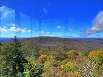 As we began the walk up the trail, I noticed that is was only damp despite the heavy rains onver the weekend. The trail was covered in a layer of fallen leaves. I decided we would get to the summit as quickly as possible and that I would forego any pictures on the way up. We almost immediately came to the first set of stone steps. They were well constructed and in just the right place to help out hikers. I also noticed that a woods road ran off to the right. I thought about walking up it some other time but realized this was DEP land and that hikers were asked to stay on the trails. We continued up the trail with Brynn and Kathleen in the lead and the rest of us close behind. We continued on the trail which was still in good shape even after it had been in place for several years. The treadway was wide and flat with few obstacles. There were several switchbacks and it was obvious that one requirement of the construction was a moderate grade. The forest at these lower elevations was primarily evergreen which is unusual in the Catskills. We did run across a few branches on the trail which we removed. At .4 miles the trail turned sharply to the left in one of its many switchback and we entered an area of hardwoods. There was a small stream that ran across the trail and the construction crew had create a deep ditch along the side of the trail. The ditch directed the water across the trail and at that point there was a stone construction to allow the water to cross the trail and hikers to easily cross the water. There was very little water flowing and the other similar constructions had no water flowing at all. We kept up a lively stream of conversation which made the hike go more quikly. I was surprised at how quickly the grandkids hiked without any complaints. At .7 miles I could see a series of ledges ahead and stone steps that wound between them. This would be repeated several more times over the next quarter mile. Getting up the steps was easy but in the winter they can be tricky. Sheila was walking the trail and then taking a few detours to follow her nose. The last set of steps was the most extensive and interesting. At 1.4 miles we came to a trail junction with the trail that comes in from the Dinch-Coons Road trailhead. The signs indicated the Dinch Road trailhead was .8 miles to the left and the fire tower was .6 miles to the right. We stopped for a few moments and then continued toward the tower.
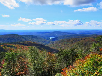 After walking a short distance, the trail began the ascent to the summit of Red Hill. The grade up to the trail junction had been 10% but now increased to 21% which I could feel! After about a quarter mile, there was a spur trail to a spring on the right side of the trail and then a short switchback. I had not climbed much on my recent hikes but this trip seemed to be easier than I had expected. It was certainly true that the company of the family made the hike seem much easier. There was plenty of sun which made me feel good but was also contributing to making me pretty warm. Soon I spotted some familiar landmakes and knew we were almost at the tower clearing. We broke out into the clearing and found Doug sitting on the porch of the observer's cabin. He immediately recognized me and we caught up on several different topics while the rest of the family headed toward the fire tower. I eventually broke away and walked over to a picnic table. I dropped my pack and got out my camera to take some pictures of the tower. I decided to tether Sheila to a picnic table knowing she would follow me up the tower or annoy other hikers. Unlike some dogs, Sheila has no problem climbing up and down the open steps but I did not want to chance it on this day. As I walked over toward the tower, another young man arrived at the clearing and started talking to Doug. Karl, who is not thrilled with heights, was coming down the tower as I started to climb the steps. Without looking, I could tell when I was above the treeline as the breeze hit me. I eventually made it to the landing below the cab and entered the cab to find Bryce and Lukas with their mother. The windows were all closed but I began to take pictures of the surrounding scenery in all directions. The views were clear and beautiful but the leaf colors were dull as I had found in several other places. The views of the Catskill peaks from this tower are spectacular and the Rondout Reservoir can be seen in the avlley. I began to take pictures at different angles and zooms trying to capture some of the colors. I find that I can never get pictures that really reflect the beauty of God's creation. After taking quite a few shots, I took some pictures of the boys in the cab. When we were all done, I started to descend the tower. On the way down, I stopped to take some more pictures from the landing below the cab. Once on the ground, I took more shots of the tower and the clearing.
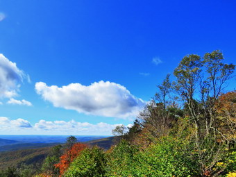 I walked back over to the picnic table and stowed the camera. I was ready to start back down but Karl explained that Doug told him we could walk passed the tower and down the access road. This used to be off limits but the DEP was now allowing public access. Doug told us there was a weather station on the right and then a bend in the trail. Just after this bend was a lookout on the left of the trail which Doug highly recommended. We started off on the road which was slightly downhill and soon came to the weather station. We followed the road an after about half a mile, the viewpoint appeared on the left. The view was spectacular and was at least as good as the ones from the tower. A short trail led down to a rock ledge and the kids ran down to sit and relax. I walked down the path and dropped my pack to get out the camera. I took pictures of the beautiful scene and then returned the camera to my pack to take some time to rest. Soon we decided to start back to the car. We walked back up the road to the tower clearing. We thanked Doug for the suggestion about the viewpoint and the started back down the trail. Not very far down the trail, we saw another family hiking up the trail. I had Bryce pout Sheila on her leash as we passed by the family greeting them as we went by. This happened two more times on the way down. It was nice to see other families out hiking! The climb up the hill had not seemed to tire the grandchildren and they were getting loud and silly, I decided to increase my pace as I want a little more peace and quiet. This work pretty well and shortened the time on the trail. We passed the spur trail to the spring and continued down the trail. The trail was damp with a good amount leaves which made itslippery but using poles really helped. We came to the turn to the left and made the turn to continue our hike back to the parking area. I could feel that the temperature had increased but I kept the fast pace with Sheila right behind me. Every time I slowed I could feel the kids closing in on me! The walk from the junction went quickly and we were soon making the turns through the bottom section of the trails. We passed through the long section of steps and continued down the trail where the kids finally caught up with us. Soon we descended the last few steps to the parking area. It was 12:30 PM and we had hiked 5 miles in 3 hours and 20 minutes with plenty of stopped time at the tower and the viewpoint. Our elevation gain was 1220 feet. The temperature had risen to 52 degrees but some clouds were moving in.
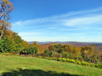
![]()
![]()
![]()
![]()
![]() On Thursday, October 5th I wanted to get out for at least a 6 mile hike and see if I could find some colorful leaves which were sorely lacking around Livingston Manor. I decided to go to the Frick Pond area and hike to the lookouts of Beech Mountain. One viewpoint has a nice view of many of the Catskills high peaks looking to the east while the other looks west over Hodge Pond. I got up at 9:00 AM giving myself some extra time to catch up on sleep after numerous ambulance calls during the week. As I was starting to get ready at 10:15 AM the pager went off and I started to get ready to respond. A few minutes later we were cancelled! This usually annoys me, but in this case I was happy. I started to get ready at 11:00 AM with Sheila watching my every move. The temperature was 73 degrees on the back porch with plenty of sun but I knew it might be cooler at the trailhead. I decided to wear my Mammut long-sleeved crew shirt without a baselayer. This shirt is a little bit warmer and appropriate for the cooler weather. I wore my Railriders hiking pants which are expensive but last along time and have features like deep pockets and a generous cut which I really like. The pants have Velcro closures at the ankles. I decided to put on my new Keen Durand hiking boots which I ordered a half size larger than the previous pair. These shoes fit well out of the box but get much tighter when I add a decent insole. Without the third party insole, by feet hurt from the lack of support. I added a new pair of Xstance insoles in an effort to find the best support and cushioning for my feet. These insoles have shock absorbing gel pads, TPU arch support, and memory foam cushioning all wrapped in a breathable fabric. The insoles have been hyped by their manufacturer and they really do seem to deliver. I decided to take my Leki poles with external locks as the internal twist locks sometimes fail. I thought about putting on my OR Crocodile gaiters to deal with the mud that might be on the trail but in the end decided against them. I thought about a jacket but decided there would be plenty of time for that. I did add my Silky Sugowaza saw just in case I ran into blowdown or two. I got my gear in the car and put an excited Sheila in the back seat as I drove out the DeBruce Road toward Frick Pond at 11:15 AM. After about 6 miles, I turned left on the Mongaup Pond and stayed left on Beech Mountain Road at the fork. There was one car parked in the smaller lot as I pulled in at 11:20 AM. I set my GPS and we immediately started our hike by crossing the road and heading out on the Flynn Trail toward Hodge Pond.
On Thursday, October 5th I wanted to get out for at least a 6 mile hike and see if I could find some colorful leaves which were sorely lacking around Livingston Manor. I decided to go to the Frick Pond area and hike to the lookouts of Beech Mountain. One viewpoint has a nice view of many of the Catskills high peaks looking to the east while the other looks west over Hodge Pond. I got up at 9:00 AM giving myself some extra time to catch up on sleep after numerous ambulance calls during the week. As I was starting to get ready at 10:15 AM the pager went off and I started to get ready to respond. A few minutes later we were cancelled! This usually annoys me, but in this case I was happy. I started to get ready at 11:00 AM with Sheila watching my every move. The temperature was 73 degrees on the back porch with plenty of sun but I knew it might be cooler at the trailhead. I decided to wear my Mammut long-sleeved crew shirt without a baselayer. This shirt is a little bit warmer and appropriate for the cooler weather. I wore my Railriders hiking pants which are expensive but last along time and have features like deep pockets and a generous cut which I really like. The pants have Velcro closures at the ankles. I decided to put on my new Keen Durand hiking boots which I ordered a half size larger than the previous pair. These shoes fit well out of the box but get much tighter when I add a decent insole. Without the third party insole, by feet hurt from the lack of support. I added a new pair of Xstance insoles in an effort to find the best support and cushioning for my feet. These insoles have shock absorbing gel pads, TPU arch support, and memory foam cushioning all wrapped in a breathable fabric. The insoles have been hyped by their manufacturer and they really do seem to deliver. I decided to take my Leki poles with external locks as the internal twist locks sometimes fail. I thought about putting on my OR Crocodile gaiters to deal with the mud that might be on the trail but in the end decided against them. I thought about a jacket but decided there would be plenty of time for that. I did add my Silky Sugowaza saw just in case I ran into blowdown or two. I got my gear in the car and put an excited Sheila in the back seat as I drove out the DeBruce Road toward Frick Pond at 11:15 AM. After about 6 miles, I turned left on the Mongaup Pond and stayed left on Beech Mountain Road at the fork. There was one car parked in the smaller lot as I pulled in at 11:20 AM. I set my GPS and we immediately started our hike by crossing the road and heading out on the Flynn Trail toward Hodge Pond.
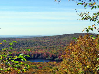 The trail was barely damp as we walked the Flynn Trail through the woods. When we hit the wide woods road that is the Flynn Trail, I realized I had walked passed the two large trees that Ranger Stratton and I had removed in August. It had certainly made the trail easier to negotiate. We turned right and I noticed that the grass was only slightly damp as was the trail bed. The woods road once led to the Beech Mountain Boy Scouts Camp. The camp was serviced by the extension of Beech Mountain Road which is now the Flynn Trail. The temperature was 68 degrees at the trailhead but I was getting warm already just from the exertion of hiking uphill. The sun was out and there were white, puffy clouds in the blue sky. We were keeping a pretty fast pace but it didn't seem to bother me. We walked passed the large hemlock tree that a DEC crew had cleared from the trail. At 1.2 miles we came to the path to the clearing on the right side of the trail. I decided that even though I had not been there for some time I would skip it as the hike I planned was already longer than I had been hiking. We continued toward the junction with the Big Rock Trail. Along the way I removed some large branches and small trunks that had fallen on the trail. Just before the junction with the Big Rock trail there was a medium-sized trunk across the trail. I probably could have cut it with my saw but decided to wait until another day when I could bring an axe. It took us 55 minutes to reach the first trail junction with the Big Rock Trail at 1.7 miles into the hike. This was faster than I expected from the pace that we were keeping.
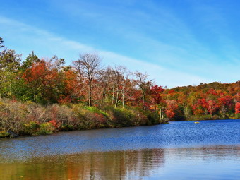 We continued straight ahead on the Flynn Trail passing through the gate that separates state land from Beaverkill Valley Land Trust property. After walking for a relatively short time, we arrived at the point where the Flynn Trail bears left down to Hodge Pond. We turned right and followed on the woods road toward the site of the Boy Scout camp and the lookouts I wanted to visit. The woods road we were walking on was once Beech Mountain Road leading to the Beech Mountain Boy Scout Camp. As we walked I had been removing small branches from the trail by habit. After a short walk, a trail turned off to the left to go down to the pond and the road we were on continued straight ahead. Another road was sandwiched in between the two and leads to the site of the former Boy Scout camp which has been leveled by the Beaverkill Valley Land Trust. At the road junction there were two signs that said "Parking" and pointed to the area of an old gravel and dirt quarry. I had no idea what event had taken place or was going to take place! We continued straight ahead on the road that started up the hill. The road was covered in leaves which were mostly brown and yellow. I could tell we were walking uphill again but I quickly adapted to the change in terrain even though I could feel it was more tiring. I was really warm now but had not brought another shirt to change into. We passed a spring house on the right and Sheila stopped to get a drink but there was barely enough water to get her feet wet. The trails so far had been much drier than I expected. The grade became steeper as we climbed the hill and at about 2.6 miles the road made a sharp turn to the right. We stopped so that I could take some pictures from a small viewpoint, but the viewpoint is now grown and there is no view so we continued on the road. As the road made another sharp turn, this time to the left, a trail went off to the right. We continued to follow the road to the left came to the top of a little hill. Several woods roads lead upward and along the ridge to Flynn's Point of Beech Mountain which is the highest point in Sullivan County. We continued on the road walking downhill. As the road turned right, I noticed the path that leads toward Mongaup Mountain, one of the CHH peaks. I knew there was a nice viewpoint there but I did not want to take the time to bushwhack out to it. We turned right on the road and came to a beautiful lookout to the east with a view of many of the Catskill high peaks. The color of the leaves was disappointing! I could not tell whether the leaves still needed some time to reach peak color or whether they were passed peak and falling. I knew this would probably be the case but was a little disappointed. I knew that the winds on Saturday might take down many of the leaves before they changed color. I took quite a few pictures before putting the camera away and continuing on the path that led up to the trail around Beech Mountain.
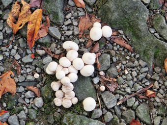 These paths and trails were marked with red markers placed by the Beaverkill Land Trust. I also noticed some very nice tent platforms near the trail but it looked like they had not been used much. We continued around the mountain a circular direction passing some interesting ledges on the right. I had tried to take some pictures of these impressive stone formations in the past but the pictures never do them justice. We continued on the path around Flynn's Point on Beech Mountain until we came to the lookout over Hodge Pond on the left. When I walked out to the stone ledge that makes up the viewpoint, I could see the leaf color was better than the last viewpoint. Most of these colors were around Hodge Pond. I took several pictures at different zooms and at different angles. When I was done, I packed up ad we continued in a clockwise direction around Beech Mountain on the woods road. I considered bushwhacking up to the Sullivan County high point but decided to continue on down to Hodge Pond as the colors were so nice there. We walked out the trail to the road and turned left. We continued on the road and set a quick pace down the hill. At the base of the hill, we turned right on the woods road that leads down to Hodge Pond. We turned left when the road intersected a jeep trail and started along the east side of the pond. I though I heard voices or music and looked down at the pond to see a bright yellow inflatable boat. I wondered if whoever was using it carried it all the way in to Hodge Pond! We continued on the road and ended up at the outlet end of Hodge Pond. We walked over to the shore of the pond where I dropped my pack and got out the camera. Sheila decided to go wading briefly and I took a few shots. The colors I had seen from the lookout were even better from the level of the pond. The colors were not as bright as I had hoped but I looked forward to coming back in a week to see how they developed. I took some shots of the pond concentrating on the leaves. I also got some pictures of some ducks on the pond diving for dinner. The outlet to the pond was still dammed up making the level of the pond high and flooding the Flynn Trail. The sky was blue with puffy white clouds. When I was done, I ate a bar and got a drink before picking up and walking to where the Flynn Trail enters the woods. We started climbing the hill back to the junction where we had turned right some time before. This ascent can sometimes seem long but on this day it went quickly. I stopped to take a few shots of some white mushrooms growing on the trail. At the top of the hill we stayed to the right on the Flynn Trail and followed the route we had taken out. We passed through the gate and continued on the trail.
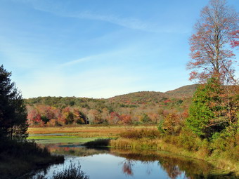 We were soon approaching the junction with the Big Rock Trail. I thought about whether to return on the Flynn Trail or add a little mileage by taking the Big Rock Trail. I decided on the Big Rock Trail since it would allow me to check out more trails. We turned right on the Big Rock Trail and started the long downhill hike. The walk down the Big Rock Trail went quickly even though there are several points where it seems the descent has ended only to continue toward Times Square. We were soon at Times Square where we continued straight across to stay on the Big Rock Trail. Times Square which is usually wet and muddy was barely damp. The trails had been almost completely dry up to this time but there were a few muddy areas on the Big Rock Trail. We passed by another large blowdown Ranger Stratton and I had cut. This one was about hip high and not easy to get over so I was glad it was gone. As we continued on the trail, we came to the two bridges over the inlet streams. The bridge abutments are beginning to deteriorate and really need to be replaced. I stopped at the first bridge to take some shots of some colorful trees. As we continued to hike, we walked through the beautiful spruce forest and over the wooden walkways which also need repair. Some sections of the walkways are poorly supported and some have boards are coming loose. I took some picture in this spruce tunnel which was hard to do as it was very sunny. We avoided the mud pit just before the junction with the Quick Lake Trail by following the detour hikers have created. Soon we were at the junction with the Quick Lake Trail where we turned left toward the bridge at the outlet of Frick Pond. The large mud pit that the Willowemoc Trail crew had worked on was still easy to cross due to the increased drainage and stepping stones. Once passed the muddy area, it wasn't long until we were at the bridge at the outlet end of Frick Pond. Despite the fact that I have hundreds of pictures from this spot, I took a few more. The trees around the pond were colorful but not quite as far along as the ones around Hodge Pond. I finished my photography and we started up the hill to Gravestone Junction. I noted that the Lobdell memorial marker was upright as we passed by. The marker is a memorial to two children who died in the 1930's in a fire that consumed their cabin. As we walked along the Quick Lake Trail back to our cars, I noticed that the trail was wet with some standing water and a few places with flowing water. The Willowemoc Trail Crew had done some work here but it is hard to drain the trail as it is the lowest spot in most areas. At the trail register, we continued straight ahead to return to the car in the smaller parking area. By 3:30 PM we were back at the car after hiking 7.3 miles in 3 hours and 45 minutes with 15 minutes of stopped time. This was good for a moving pace of 2.0 mph. We also gained 1305 feet of elevation.
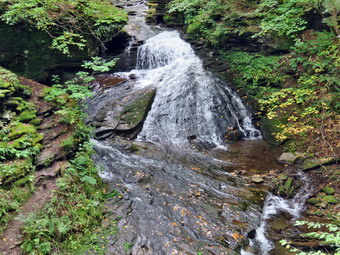
![]()
![]()
![]()
![]()
![]() On Monday, October 2nd I planned to get in a slightly longer hike with a little elevation gain. From Saturday morning to Monday afternoon I had been on ambulance calls ranging from a house that exploded to call canceled as we were arriving on scene and I needed to get away! I have gotten into the habit of staying in Livingston Manor and taking short hikes so that I can respond to calls. This is not good for my physical or mental health! I asked Cindy if she would like to go to Trout Pond and she agreed. We began getting ready at 12:15 PM with overcast and hazy skies from wildfires burning far away. As we were getting ready the temperature was 62 degrees. Sheila was pretty excited as we started to get ready as she always is when we go hiking. She switches between Cindy and I sniffing our clothing and whining. I decided to wear my Mammut long-sleeved crew shirt without a baselayer. This shirt is a little bit warmer and appropriate for the cooler weather. I wore my Railriders hiking pants which are expensive but last along time and have features like deep pockets and a generous cut which I really like. The pants have Velcro closures at the ankles. I decided to put on my new Keen Durand hiking boots which I ordered a half size larger than the previous pair. These shoes fit well out of the box but get much tighter when I add a decent insole. Without the third party insole, by feet hurt from the lack of support. I added a new pair of Xstance insoles in an effort to find the best support and cushioning for my feet. These insoles have shock absorbing gel pads, TPU arch support, and memory foam cushioning all wrapped in a breathable fabric. The insoles have been hyped by their manufacturer and they really do seem to deliver. I decided to take my Leki poles with external locks as the internal twist locks sometimes fail. I thought about putting on my OR Crocodile gaiters to deal with the mud that might be on the trail but in the end decided against them. I thought about a jacket but decided there would be plenty of time for that. I put our gear in the back of the car and Sheila in the back seat. We left Livingston Manor at 12:20 PM as I drove north on the Quickway towards Roscoe. I got off at exit 94 and headed north on Route 206 towards Downsville. After crossing the Rockland Flats and passing the Roscoe Nursing Home, I turned left on Morton Hill Road and drove to the intersection with Russell Brook Road. There were twp cars sitting in the "lot" at the intersection of the two roads. People see the open space and park there without thinking about the fact that the land is private. I knew Cindy would not want to have to walk back up Russell Brook Road at the end of the hike so I decided to drive down the road to park in the lower lot. Russell Brook Road is a seasonal maintenance road and it did look like it had recently been maintained. There was a car parked at the camping area on the left side of the road and another across the road in a spot which is not for parking. I drove a little further down the road and pulled over on the right at the viewpoint over the upper falls. I grabbed my camera from my pack and walked down the steep bank to the viewpoint. I was surprised to see that the folume of water was very low but I took some shots anyway. I walked back up the bank wondering about the low volume of water in the stream. I drove down to the lower parking lot and parked the car next to two others.
On Monday, October 2nd I planned to get in a slightly longer hike with a little elevation gain. From Saturday morning to Monday afternoon I had been on ambulance calls ranging from a house that exploded to call canceled as we were arriving on scene and I needed to get away! I have gotten into the habit of staying in Livingston Manor and taking short hikes so that I can respond to calls. This is not good for my physical or mental health! I asked Cindy if she would like to go to Trout Pond and she agreed. We began getting ready at 12:15 PM with overcast and hazy skies from wildfires burning far away. As we were getting ready the temperature was 62 degrees. Sheila was pretty excited as we started to get ready as she always is when we go hiking. She switches between Cindy and I sniffing our clothing and whining. I decided to wear my Mammut long-sleeved crew shirt without a baselayer. This shirt is a little bit warmer and appropriate for the cooler weather. I wore my Railriders hiking pants which are expensive but last along time and have features like deep pockets and a generous cut which I really like. The pants have Velcro closures at the ankles. I decided to put on my new Keen Durand hiking boots which I ordered a half size larger than the previous pair. These shoes fit well out of the box but get much tighter when I add a decent insole. Without the third party insole, by feet hurt from the lack of support. I added a new pair of Xstance insoles in an effort to find the best support and cushioning for my feet. These insoles have shock absorbing gel pads, TPU arch support, and memory foam cushioning all wrapped in a breathable fabric. The insoles have been hyped by their manufacturer and they really do seem to deliver. I decided to take my Leki poles with external locks as the internal twist locks sometimes fail. I thought about putting on my OR Crocodile gaiters to deal with the mud that might be on the trail but in the end decided against them. I thought about a jacket but decided there would be plenty of time for that. I put our gear in the back of the car and Sheila in the back seat. We left Livingston Manor at 12:20 PM as I drove north on the Quickway towards Roscoe. I got off at exit 94 and headed north on Route 206 towards Downsville. After crossing the Rockland Flats and passing the Roscoe Nursing Home, I turned left on Morton Hill Road and drove to the intersection with Russell Brook Road. There were twp cars sitting in the "lot" at the intersection of the two roads. People see the open space and park there without thinking about the fact that the land is private. I knew Cindy would not want to have to walk back up Russell Brook Road at the end of the hike so I decided to drive down the road to park in the lower lot. Russell Brook Road is a seasonal maintenance road and it did look like it had recently been maintained. There was a car parked at the camping area on the left side of the road and another across the road in a spot which is not for parking. I drove a little further down the road and pulled over on the right at the viewpoint over the upper falls. I grabbed my camera from my pack and walked down the steep bank to the viewpoint. I was surprised to see that the folume of water was very low but I took some shots anyway. I walked back up the bank wondering about the low volume of water in the stream. I drove down to the lower parking lot and parked the car next to two others.
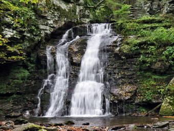 I had not brought my GPS unit as we had done the hike many times before. We started our hike at 12:40 PM by walking down the woods road toward the bridge across Russell Brook. The road was almost dry with no mud. As we crossed the bridge, I could see that the brook wasn't very high which was surprising as there had been recent rain storms in many areas. We decided to go to the falls at the beginning of the hike rather than to save a visit for the return trip. The Japanese knotweed was still very much alive and encroaching on the path. I stopped and took a few pictures. We turned to the right on the path that leads to the falls. The path was very narrow and overgrown despite an indication that people were visiting the area. I walked to the spot where the path descends to the streambed and walked down to the bottom. I put down my pack and got out my camera. I took some pictures of the falls at different angles and zooms. I also took shots of the stream. The volume was very low and I began to realize that this area had not gotten much, if any, of the rain from the recent storms. I had Sheila pose in front of the falls and then returned to my pack. I put away the camera and we returned to the main trail where we turned right. The history of this area is very interesting. Russell Brook Falls had been the site of a dam that impounded water for a waterwheel in Butternut Grove. The wheel was still there a few years ago. The area near the register box was the "landing zone" for loggers who cleared the evergreen trees, not for tanning but, for the production of wood alcohol. The trees were transported on narrow gauge railway that ran parallel to Russell Brook. The railway met the mainline O&W near Butternut Grove where the logs were unloaded. There were several acid factories in the area that produced wood alcohol. There was also a factory on the lower part of Russell Brook that produced khaki dye for the uniforms of American troops during World War I. We followed the main trail passed the register box and up the trail toward Trout Pond. The trail was almost dry which was a contrast to many times when it has been wet and muddy. I did notice that wherever the trail was damp or muddy that there were tire tracks that formed a deep impression into the trail. Crews come to work on the bridge and lean-tos amd do a great job but cause problems on the trails which they do not fix.
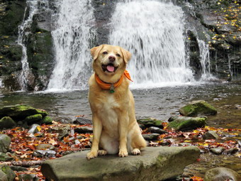 As we walked up the trail we met a young man walking toward us. I pulled Sheila off the trail as he passed. We said "Hello" and he responded. We continued and soon met an older man and a young girl. I again corralled Sheila and greeted the two as they passed. We started back on the trail and almost immediately met a woman hiking toward us. I cam to the conclusion that this was a family of four hiking at slightly different speeds. We weren't pushing the pace but the walk seemed to go very quickly as we passed the path to the first primitive campsite on the left. We could hear the outlet stream from Trout Pond and I explained to Cindy how, on my last visit, I had walked down to the stream and bushwhacked up to the dam at the outlet end of Trout Pond. I told her about all the interesting rapids and small falls I had seen. Soon we were at the outlet end of the pond and we walked over to the shore where the water was low enough to have a nice "beach". I dropped my pack to take pictures of the lake. The skies were clearing and the sun was shining through in places. The leaves were as pretty and as colorful as we had seen anywhere. I kept seeing new shots to take. Sheila took a quick dip and I took a few pictures. I packed up and we returned to the main trail to walk the flat woods road toward the inlet end of the pond. This trail is always wet but on this day the large ponds that had been present the last time were almost dry! I stopped several times to take pictures of the trail and some across the lake to take in the leaves. The small stream just before the trail junction near the leanto was easily crossed as it was almost dry. When we came to the bridge, I stopped to take a few pictures of the pond from just before the bridge and from the bridge itself. There were two hikers on the trail that leads to the upper lean-to and we let them go ahead of us in the trail that starts up Cherry Ridge. The fire pit at the lower lean-to was smoldering and I did not see anyone around. I thought about walking over to see the modifications that had recently been done to make the lean-to and privy ADA compliant but decided to continue hiking. We crossed the bridge and stayed to the right on the Mud Pond Trail which would take us over Cherry Ridge and form our loop back to the parking area. The trail was nearly dry but very rocky as we started to ascend the hill. As we continued up the trail, we both slowed a little as the grade increases. There had been some very large trees across the trail but they had been cut by a DEC crew or the rangers.
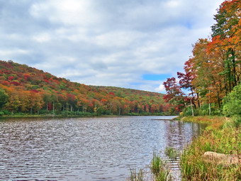 From the bridge at the inlet we climbed 430 feet over the next .75 miles. The trail headed west from the inlet until turning sharply south at around 2.3 miles. The highest point on the trail was at 2.2 miles after which most of the rest of the hike is downhill. I was getting a little tired on the climb and wondered if Cindy was having any problems. I slowed my pace a little but Cindy seemed to be doing alright despite her aversion to assigning. As we started down the other side, the trail was damp in spots but there was no standing or running water which I have some to expect. The relatively dry conditions continued for the rest of the trip making the hike more enjoyable than my last outing here. We ascended a small hill to the stand of small birch trees and then descended the other side where there was some mud. At 3.7 miles we had descended 420 feet from Cherry Ridge to the snowmobile trail near Mud Pond. I could see that the trail was just damp so we stayed on the woods road. We ascended a small hill before starting downhill back toward the parking area. This section usually has some running water across the trail but on this day all the streams were dried up. All told, we dropped another 380 feet over the next .7 miles back to the bridge just before the trail register. We stopped on the bridge over the outlet stream from Trout Pond and I pointed out to Cindy how high it had been last time. We continued on the trail to the junction and turned right and continued on the main trail toward the parking area. We continued across the bridge and up the trail to the parking area where there were now two diffeent cars parked. We were back at the car at 3:35 PM and we had hiked 4.3 miles in 2 hours and 55 minutes with an elevation gain of 863 feet. We had stopped many times for pictures and to look around.
![]()
![]()
![]()
![]() On Thursday, September 28th I planned to get out for a hike inbetween ambulance calls and afternoon girls soccer that I was timing. The temperature was 64 degrees and I decided to go across the street to Round Top to hike a clear a few small trees that had fallen on the trail. I knew Cindy does not like the climbs but I asked her anyway and to my surprise she agreed. As we began to get ready just after 12:30 PM, Sheila was keeping a careful eye on both of us as we dressed. Sheila often examines and sniffs our clothing to make sure we are serious about hiking. I decided to wear my Mammut long-sleeved crew shirt without a baselayer. This shirt is a little bit warmer and appropriate for the cooler weather. I wore my Railriders hiking pants which are expensive but last along time and have features like deep pockets and a generous cut which I really like. The pants have Velcro closures at the ankles. I decided to put on my new Keen Durand hiking boots which I ordered a half size larger than the previous pair. These shoes fit well out of the box but get much tighter when I add a decent insole. Without the third party insole, by feet hurt from the lack of support. I added a new pair of Xstance insoles in an effort to find the best support and cushioning for my feet. These insoles have shock absorbing gel pads, TPU arch support, and memory foam cushioning all wrapped in a breathable fabric. The insoles have been hyped by their manufacturer and they really do seem to deliver. I decided to take my Leki poles with external locks as the internal twist locks sometimes fail. I thought about putting on my OR Crocodile gaiters to deal with the mud that might be on the trail but in the end decided against them. I thought about a jacket, hat, and gloves but decided there would be plenty of time for them. I didn't think I would be taking any pictures but I did put my silky Sugowaza saw in my pack which I hoped was all I would need to clear the trails. At 12:55 PM we walked out the door to start the hike. I grabbed Sheila's leash from my car and put it on her as we walked up the driveway. I aimed to hike for about an hour and clear the trails as we went. I left my pager and phone at home so that I could have some time without worrying about ambulance calls! Sheila was happy to get out as we headed down the driveway and across the street. We crossed the street and walked to the parking lot next to the Presbyterian Church. We walked to the back of the church and began the ascent of the steepest hill behind the church. The hill is short but gets the circulation pumping and is the steepest and longest climb on the "trail." We stopped a couple of times for Cindy to catch her breath but were soon at the top of the hill. At the top of the hill we paused for a minute so we could look around at the hills that surround the hamlet of Livingston Manor. The skies were overcast and it even looked like it might rain. The trees all around us were beginning to turn colors and some leaves were falling. I had my pack but had not included my camera. I was a little sorry I did not have the camera as there were some good photographic opportunities. We continued the hike by turning left at the trailhead. The trail was bare but damp in a few places.
On Thursday, September 28th I planned to get out for a hike inbetween ambulance calls and afternoon girls soccer that I was timing. The temperature was 64 degrees and I decided to go across the street to Round Top to hike a clear a few small trees that had fallen on the trail. I knew Cindy does not like the climbs but I asked her anyway and to my surprise she agreed. As we began to get ready just after 12:30 PM, Sheila was keeping a careful eye on both of us as we dressed. Sheila often examines and sniffs our clothing to make sure we are serious about hiking. I decided to wear my Mammut long-sleeved crew shirt without a baselayer. This shirt is a little bit warmer and appropriate for the cooler weather. I wore my Railriders hiking pants which are expensive but last along time and have features like deep pockets and a generous cut which I really like. The pants have Velcro closures at the ankles. I decided to put on my new Keen Durand hiking boots which I ordered a half size larger than the previous pair. These shoes fit well out of the box but get much tighter when I add a decent insole. Without the third party insole, by feet hurt from the lack of support. I added a new pair of Xstance insoles in an effort to find the best support and cushioning for my feet. These insoles have shock absorbing gel pads, TPU arch support, and memory foam cushioning all wrapped in a breathable fabric. The insoles have been hyped by their manufacturer and they really do seem to deliver. I decided to take my Leki poles with external locks as the internal twist locks sometimes fail. I thought about putting on my OR Crocodile gaiters to deal with the mud that might be on the trail but in the end decided against them. I thought about a jacket, hat, and gloves but decided there would be plenty of time for them. I didn't think I would be taking any pictures but I did put my silky Sugowaza saw in my pack which I hoped was all I would need to clear the trails. At 12:55 PM we walked out the door to start the hike. I grabbed Sheila's leash from my car and put it on her as we walked up the driveway. I aimed to hike for about an hour and clear the trails as we went. I left my pager and phone at home so that I could have some time without worrying about ambulance calls! Sheila was happy to get out as we headed down the driveway and across the street. We crossed the street and walked to the parking lot next to the Presbyterian Church. We walked to the back of the church and began the ascent of the steepest hill behind the church. The hill is short but gets the circulation pumping and is the steepest and longest climb on the "trail." We stopped a couple of times for Cindy to catch her breath but were soon at the top of the hill. At the top of the hill we paused for a minute so we could look around at the hills that surround the hamlet of Livingston Manor. The skies were overcast and it even looked like it might rain. The trees all around us were beginning to turn colors and some leaves were falling. I had my pack but had not included my camera. I was a little sorry I did not have the camera as there were some good photographic opportunities. We continued the hike by turning left at the trailhead. The trail was bare but damp in a few places.
We passed by all the places where I had cut trees to remove them from the trail. At the first trail junction, we followed Sheila as she turned right and started up the woods road which has the gentler approach of the two. There were a few branches on the trail from the winds that had passed through the area. I removed these branches either by dragging them off the trail or by using my poles on the smaller ones. It was a pleasure to walk on the trails and it was obvious more people were using them. We reached the end of the woods road and turned left up the hill on the trail. I could see the frame and tarps that covered the mouth of one of the "caves". They were looking ragged as if no one had used them for some time. We continued up the trail to the first trail junction with the upper blue trail where there was a long but small diameter trunk arcoss the trail. I put the pack down and got out the saw. I cut the tree on the side of the trail opposite the stump. I then turn my attentions to the other end. I cut around the stump in an effort to loosen the trunk. The wood was wet and stringy so I had to get tough and kick it a couple of times before lifting and dropping it which finally broke it loose. I dragged the trunk off the trail and we resumed our walk by turning left to follow the yellow trail along the base of Round Top. In a short distance there was another somewhat larger white birch across the trail. The trunk was very long and I did not know whether I could cut it without pinching the saw. I had Cindy stabilize the trunk while I cut the trunk on the top side off the trail. This went quickly without the saw binding. I went to the other side of the trail and started to cut the wider part of the trunk which was nearer the stump. This also went quickly and a large section was soon on the ground. I was able to lift this piece and throw it into the woods. I pit the saw back in its scabbard in the pack and we continued on the yellow trail along the base of Round Top. A little farther along we found some bushes leaning over into the trail. I put down the pack and got out the saw and made short work of them. Back on the trail we came to the next junction with the blue trail. We turned right and headed up the blue trail toward the summit. When we got to the switchback, we turned right and followed it until it came back to the main blue trail. The fact that the switchback sidehills in places made the walk a little more difficult. We turned right and then continued straight ahead and up the hill toward the summit of Round Top bypassing the white crossover trail. As we walked over the high point, I removed a couple of branches off the trail. We continued over the summit and down the blue trail toward the junction with the yellow trail. We bypassed the white crossover trail again and continued down to the yellow trail. At the junction with the yellow trail we turned right and walked the yellow trail along the base of Round Top to the next junction with the blue trail. We turned left and started slightly downhill toward the lookout over town. We passed the "sitting rock" and continued downhill through a sea of ferns which were turning brown.
When we reached the lookout, I regretted leaving my camera home as there were some pretty views down to town and the school from the viewpoint. There were also some nice views of the hills around town. Normally, we follow the yellow trail as it turns left and descends the steep hill back to the first trail junction. This means when we turn around we have to climb that short but steep hill. In an effort to keep Cindy with me I offered to turn around at the lookout to avoid that climb and Cindy reluctantly agreed. Sheila seemed pleased as she dashed ahead of us up the trail. We followed the trail as it turned right and headed uphill toward the junction with the blue trail. We hiked up a short but steep little hill and arrived at the trail junction. We turned right to follow the trail along the base of Round Top. Sheila was some distance ahead when she came roaring back at us at full speed. She passed us, made a 180 degree turn, and came running back. She repeated this several times before I called her off. We arrived at the next junction with the blue trail and I turned left to start the walk up the blue trail toward the summit. Cindy decided she did not want to go up and would wait for us at the junction. Sheila and I continued toward the summit but turned left on the white crossover trail. I was surprised there were no trunks or branches on this trail. We were soon at the blue trail where we turned left and then left again on the switchback in the blue trail. We followed the switchback out into the forest and then back to the main trail. We turned left and walked downhill to the yellow trail where a left turn again took us along the base of Round Top. At the junction, I looked for Cindy but she was not there as she had promised. I hoped she had followed the trail to the trailhead! Sheila and I turned right and walked down the trail to the woods road. We followed the woods road downhill with the ledges to the right. On the way we passed two young people sitting on a log to the left of the trail. They were smoking and a sweet, coying odor wafted in our direction. They said a woman had just walked passed them and Sheila and I sped up to catch her. At the first trail junction, we turned left and walked straight out to the trailhead. We turned right and walked downhill spotting Cindy about a third of the way down the hill. We caught up to her and we all walked down the hill and crossed the parking lot to the road. We waited to cross the road as several cars went by and then crossed to the driveway to the house. It was 2:15 PM and we had hiked a little over 2 miles and done some trail maintenance in 1 hour and 20 minutes.
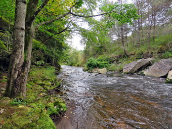
![]()
![]()
![]()
![]()
![]() On Tuesday, September 26th I wanted to get out for a hike after almost a week off for ambulance calls, bad weather and church commitments; not necessarily in that order. This had delayed our first hike of the fall and I wondered if we would see many trees changing color. I decided I would go to the Parksville Rail Trail for a quick hike as I wanted to see what the recent heavy rain had done to the volume of the stream and the falls. I asked Cindy if she would like to go along and she said "Yes". I think we both felt it would be a good day to hike as the temperature was 62 degrees and the humidity was low with a slight breeze. The skies were blue with some sun and some nice white clouds. We started to get ready at 12:15 PM with Sheila keeping a watchful eye on both of us. The Parksville Rail Trail is about 2.5 miles with a beautiful waterfall. I decided to leave my pager and phone home as I knew others were around to respond and I need a break. As we were getting dressed it looked as if Sheila thought we might not hike again! I decided to wear my Mammut long-sleeved crew shirt without a baselayer. This shirt is a little bit warmer and appropriate for the cooler weather. I wore my Railriders hiking pants which are expensive but last along time and have features like deep pockets and a generous cut which I really like. The pants have Velcro closures at the ankles. I decided to put on my new Keen Durand hiking boots which I ordered a half size larger than the previous pair. These shoes fit well out of the box but get much tighter when I add a decent insole. Without the third party insole, by feet hurt from the lack of support. I added a new pair of Xstance insoles in an effort to find the best support and cushioning for my feet. These insoles have shock absorbing gel pads, TPU arch support, and memory foam cushioning all wrapped in a breathable fabric. The insoles have been hyped by their manufacturer and they really do seem to deliver. I decided to take my Leki poles with external locks as the internal twist locks sometimes fail. I thought about putting on my OR Crocodile gaiters to deal with the mud that might be on the trail but in the end I forgot them. I thought about a jacket, hat, and gloves but decided there would be plenty of time for them.
On Tuesday, September 26th I wanted to get out for a hike after almost a week off for ambulance calls, bad weather and church commitments; not necessarily in that order. This had delayed our first hike of the fall and I wondered if we would see many trees changing color. I decided I would go to the Parksville Rail Trail for a quick hike as I wanted to see what the recent heavy rain had done to the volume of the stream and the falls. I asked Cindy if she would like to go along and she said "Yes". I think we both felt it would be a good day to hike as the temperature was 62 degrees and the humidity was low with a slight breeze. The skies were blue with some sun and some nice white clouds. We started to get ready at 12:15 PM with Sheila keeping a watchful eye on both of us. The Parksville Rail Trail is about 2.5 miles with a beautiful waterfall. I decided to leave my pager and phone home as I knew others were around to respond and I need a break. As we were getting dressed it looked as if Sheila thought we might not hike again! I decided to wear my Mammut long-sleeved crew shirt without a baselayer. This shirt is a little bit warmer and appropriate for the cooler weather. I wore my Railriders hiking pants which are expensive but last along time and have features like deep pockets and a generous cut which I really like. The pants have Velcro closures at the ankles. I decided to put on my new Keen Durand hiking boots which I ordered a half size larger than the previous pair. These shoes fit well out of the box but get much tighter when I add a decent insole. Without the third party insole, by feet hurt from the lack of support. I added a new pair of Xstance insoles in an effort to find the best support and cushioning for my feet. These insoles have shock absorbing gel pads, TPU arch support, and memory foam cushioning all wrapped in a breathable fabric. The insoles have been hyped by their manufacturer and they really do seem to deliver. I decided to take my Leki poles with external locks as the internal twist locks sometimes fail. I thought about putting on my OR Crocodile gaiters to deal with the mud that might be on the trail but in the end I forgot them. I thought about a jacket, hat, and gloves but decided there would be plenty of time for them.
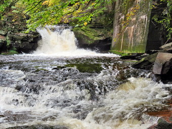 At 12:40 PM I put our gear in the car and Sheila in the back seat and headed out Old Route 17 and drove across the Flats. I took Old Route 17 and Service Road to the point where they meet Fox Mountain Road. There were no vehicles in the parking lot which was surprising for such a beautiful day. We departed the parking area at 12:55 PM with the temperature at 62 degrees. The open trail just before the woods was pretty damp and showed some erosion from the steady rain that had occurred lately. I checked the bushes that I had cut back and they remained well off the trail. We moved on toward the wooded part of the trail. We immediately ran into some mud pits with more water and mud than ourlast trip. One look down to the Little Beaverkill showed the stream volume was higher than I expected with a good volume of water. I wondered about the condition of the falls and whether they would be as more interesting than my last trip. Sheila was taking her own route and following her nose and getting very close to the edge of the trail where a steep drop led down to the river! We began to run into some branches hanging into the trail from the side and above. There were two new trunks hanging across the trail which I knew I could cut with a saw. I did pick up some newly fallen branches and throw them off the trail. I continued to do this for the rest of the hike as the winds from the storms had loosened branches that had then fallen on the trail. We crossed several muddy areas which were longer and wider than they had been in some times but we were soon at the wooden walkways. I decided not to take some pictures of the stream and sky from the viewpoint as there was nothing very different. We continued over the wooden walkways and bridges which were wet and muddy from the rain. I thought about bringing a rake and a broom next time to clean off the bridges which were covered in a mixture of wet leaves and mud. This time the water from the small stream was eroding deep channels on the near and far sides of the bridge rather than flowing through the culvert under the bridge. After crossing the bridge, we ran into another large mud pit that had a layer of water with a few stepping stones. There continued to be small branches to remove as we walked.
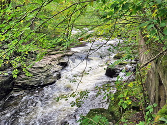 As we approached the falls, we could hear a loud sound which was the falls. We arrived at the falls and found that there was a nice flow of water. The volume seemed lower than the highest we had seen but it was well above anything we had seen during the summer. The water was mostly clear as it flowed over the falls to the basin below. I decided to go down to the streambed to take pictures even though I have quite a few pictures from the base of the falls. I took my pack and poles with me as Sheila and I headed down the bank to the stream. I put my pack down by the stream and took out my camera. I took some shots downstream where the light was illuminating the stream and the surrounding banks. I then turned my attention to the falls. I took some shots of the upper falls and lower rapids. After the wide-angle pictures, I took some close-ups of both falls. When I finished, we climbed back up the bank. I took some shots of the falls from above from different locations and different angles. I also took picture upstream from this higher angle. I could see that the path along the edge of the stream was almost completely covered with water. We moved on down the trail and I decided not to stop at the next bench. We started toward the Parksville end of the trail at an accelerated pace. Along the way we ran into some loud music and an even louder dog. The dog was on the other shore of the stream and really looked and sounded like he wanted to join us. We continued on to the end of the trail where we turned around at the sign detailing the hotels in Parksville. It was 1:35 PM and we set a respectable pace back toward the parking area which was even faster as we were not stopping to remove branches or take pictures. I think we were both lost in our own thoughts as we did not talk much while walking. As we broke out of the trees, I could see a woman with two dogs on leashes coming toward us from the parking lot. We passed by each other with a quick "Hello". We arrived at the car at 2:15 PM after hiking about 3.0 miles in 1 hour and 20 minutes. There is virtually no elevation gain on the hike but carrying a pack helps with the exercise.