| Pick a Catskill 35 Peak: |
Indian Head
Indian Head is often climbed in conjunction with Twin. The more adventuresome and fit may also include Sugarloaf. Twin has some of the most beautiful views in the Catskills. From Indian Head, you can see Kaaterskill High Peak and the Catskill Community or Bruderhof at the old police camp.
| Trailhead Coordinates | |
|---|---|
| Name | Coordinates |
| Prediger Road | N42.1339 W74.1043 |
| Roaring Kill | N42.1512 W74.1315 |
| Platte Clove | N42.1338 W74.0819 |
| Quick Look - Indian Head loop (Clockwise Prediger) | ||||
|---|---|---|---|---|
| Difficulty | Round trip | Total climb | Location | Internet Maps |
| 6.2 mi. | 1845 ft. | N42.1161 W74.1150 | AllTrails | |
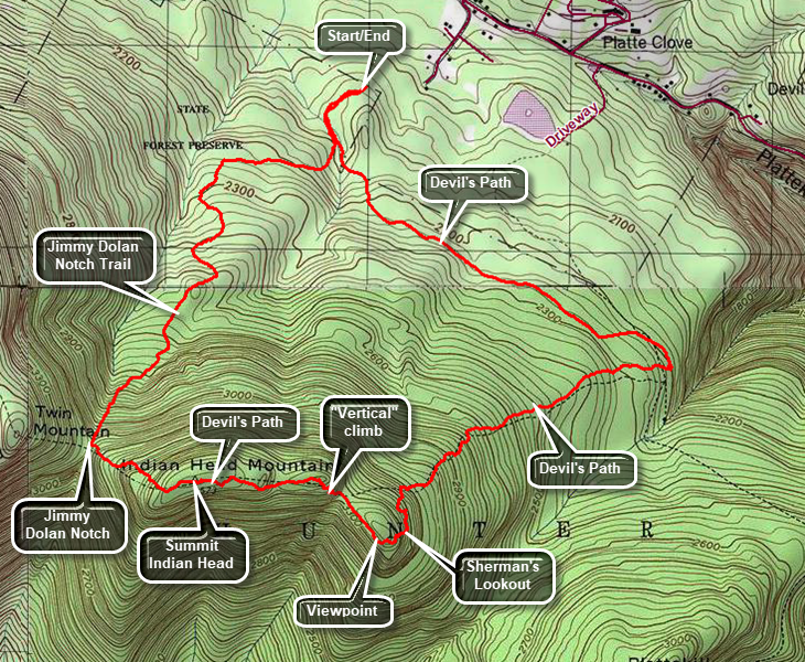
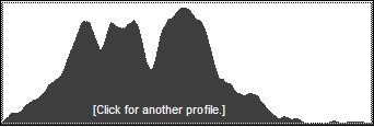
Turn onto Bloomer Rd. off Route 23A just west of Tannersville. At the Y in the road bear left onto Platte Clove Rd. Continue on this road to Prediger Road on the left. Drive to the end of the road and turn right onto the access road to the trailhead parking. Exit the parking lot on the Devil's Path and walk .3 miles to the first trail junction. Stay to left on the red-blazed Devil's Path. Walk 1.3 miles on a trail that is often muddy and gains and loses elevation. At the next trail junction turn right and walk a short distance to another right turn. At this point the Devil's Path turns up the mountain and starts to climb. Along the way to the summit you will find rock and root scrambles varying from short and easy to longer and more challenging. There are also several lookouts along the way. At 2.85 miles you will have climbed over 1300 feet from the trailhead. Your reward is Sherman's Lookout which gives spectacular views of over 180 degrees from Kaaterskill High Peak and Round Top to the north to Plattekill Mountain to the south. Also visible are the Catskill Bruderhof in the shadow of Kaaterskill High Peak and the ribbon of the Hudson River. A little farther up the trail a left turn will bring you to another lookout to the south. Echo Lake and Overlook Mountain are visible from this viewpoint. Just after this lookout is the most interesting rock scramble on the trail. It is almost vertical but had plenty of foot placements and handholds. At the top of this climb there is another lookout which gives a nice view of the false peak of Indian Head. Continue on the trail through some more rock scrambles and at 3.8 miles you will be at the summit. A limited viewpoint shows Overlook Monutain with the television tower and to the left of it the Overlook fire tower. The trail now descends a rocky .5 miles to Jimmy Dolan Notch which is the col between Indian Head and Twin. Turn right on the blue-blazed Jimmy Dolan Notch Trail and get ready for a rocky nightmare on your descent. The trail eventually levels some but the rocks and roots remain. Follow the blazes as the trail has been reputed at least once and is hard to follow. Eventually you will be back at the very first trail junction with only .3 miles to go back to the parking area.

| Quick Look - Indian Head and Twin from Kaaterskill PA | ||||
|---|---|---|---|---|
| Difficulty | Round trip | Total climb | Location | Internet Maps |
| 9.2 mi. | 2700 ft. | N42.1161 W74.1150 | AllTrails | |
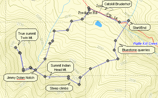
Turn onto Bloomer Rd. off Route 23A just west of Tannersville. At the Y in the road bear left onto Platte Clove Rd. Continue on this road passed the Catskill Bruderhof and pull into the parking Lot for Kaaterskill High Peak. Walk back down the access road and take a right on Platte Clove Rd. Walk a short distance to the Platte Clove Preserve owned by the Catskill Center. Get on the aqua-blazed trail which is part of the Long Path. Follow this for .95 miles to the junction with the Overlook Trail and the Devil's Path. Turn right on the red-blazed Devil's Path. Ascend 1.25 miles through some steep areas to a lookout to the north. From here you can see the profile of Kaaterskill High Peak and a view of the Bruin. Continue on the trail for another .5 miles and get the view from another spectacular lookout. The peak of Indian Head Mountain (3573 ft.) is another .65 miles ahead. At this point you can retrace your route or continue down the other side to Jimmy Dolan Notch. At the notch you can turn back to the parking area or climb Twin Mountain. The best choice is to do Twin while you are there.
Follow the Devil's Path for .4 miles until you arrive at Jimmy Dolan Notch. Continue straight ahead
and up. The east summit of Twin Mountain is .4 miles ahead. At this point you will walk out onto a flat
rock prominence which gives a wonderful view of the valley below and includes Indian Head, Sugarloaf
and Plateau Mountains. In another .7 miles you will be at the summit of Twin Mountain (3640 ft.) Take
in the view an then turn around an return the 1.5 miles to Jimmy Dolan Notch. Now turn left on the
blue-blazed Jimmy Dolan Notch Trail and walk 1.2 miles downhill to an old logging road. In another
.4 miles, after you walk through the new parking area, you will be at the end of Prediger Road. Walk .2 miles to the end of Prediger Road
and turn right on Platte Clove Rd. Walk about 1 mile passed the Catskill Bruderhof and back to the
parking area.

| Quick Look - Indian Head and Twin Loop from Prediger Road | ||||
|---|---|---|---|---|
| Difficulty | Round trip | Total climb | Location | Internet Maps |
| 8.4 mi. | 2590 ft. | N42 06.98 W74 06.90 | AllTrails | |
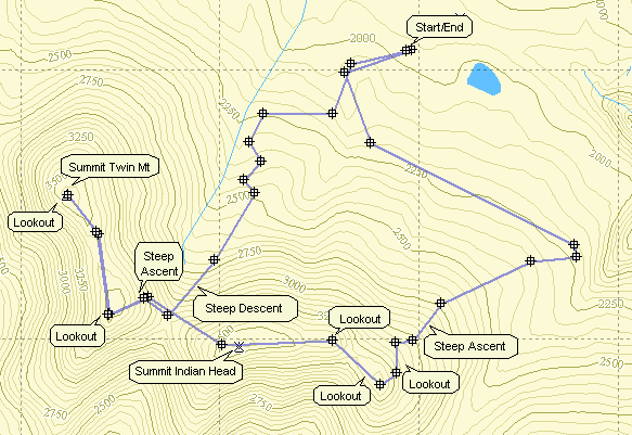
Turn onto Bloomer Rd. off Route 23A just west of Tannersville. At the Y in the road bear left onto
Platte Clove Rd. Continue on this road for about 3.75 miles and turn right on Prediger Rd. Go to the end
of the road and park on the right side obeying the signs the private landowner has posted. The Devil's Path
actually begins at the intersection of Prediger Rd and Platte Clove Road! Get on the red-blazed Devil's Path
and hike .25 miles to the junction with the Jimmy Dolan Notch Trail. Bear left staying on the Devil's Path.
After 1.5 miles turn left on the Overlook Road. Walk a short distance and turn right on the Devil's Path.
After 1.25 miles and several steep ascents there is a very nice lookout to the north. From here you can see the
Catskill Bruderhof with Kaaterskill High Peak behind it. Another .5 miles of ascent brings another lookout.
Continue for another .65 miles to the summit of Indian Head Mountain. Continue on a descent for .4 miles into
Jimmy Dolan Notch. Another .4 miles of steep climbing brings you to the east peak of Twin Mountain. The view
from this rock ledge on a clear day is hard to match anywhere in the Catskills. Since this peak is NOT the
highest on Twin, continue another .7 miles to "bag" the higher west peak. Retrace your footsteps to Jimmy
Dolan Notch. Turn left on the blue-marked Jimmy Dolan Trail. Continue following the markers for 1.6 miles
at which time the trail intersects the Devil's Path. Turn left and hike .25 miles back to the parking area.

| Quick Look - Indian Head and Twin from Prediger Road | ||||
|---|---|---|---|---|
| Difficulty | Round trip | Total climb | Location | Internet Maps |
| 6.8 mi. | 2270 ft. | N42 06.98 W74 06.90 | AllTrails | |
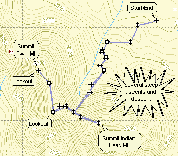
Turn onto Bloomer Rd. off Route 23A just west of Tannersville. At the Y in the road bear left onto
Platte Clove Rd. Continue on this road for about 3.75 miles and turn right on Prediger Rd. Go to the end
of the road and turn right onto the access road for the new parking area. The Devil's Path
actually begins at the intersection of Prediger Rd and Platte Clove Road! After parking in the new parking area, get on the red-blazed Devil's Path
and hike .25 miles to the junction with the Jimmy Dolan Notch Trail. Bear right on the Jimmy Dolan Trail.
Hike 1.6 miles to Jimmy Dolan Notch. Turn left and hike the .4 miles to the summit of Indian Head. Retrace
your steps back to the Notch and continue straight ahead on the red-marked Devil's Path. About .4 miles of
steep climbing brings you to the east peak of Twin Mountain. The view from this rock ledge on a clear day is
hard to match anywhere in the Catskills. Since this peak is NOT the highest on Twin, continue another .7 miles
to "bag" the higher west peak. Retrace your footsteps to Jimmy Dolan Notch. Turn left on the blue-marked Jimmy
Dolan Trail. Continue following the markers for 1.6 miles at which time the trail intersects the Devil's Path.
Turn left and hike .25 miles back to the parking area.

| Quick Look - Indian Head, Twin and Sugarloaf Loop from Prediger Road | ||||
|---|---|---|---|---|
| Difficulty | Round trip | Total climb | Location | Internet Maps |
| 9.9 mi. | 4000 ft. | N42 06.98 W74 06.90 | AllTrails | |
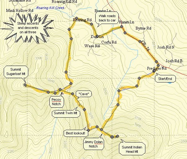
Turn onto Bloomer Rd. off Route 23A just west of Tannersville. At the Y in the road bear left onto Platte Clove Rd. Continue on this road for about 3.75 miles and turn right on Prediger Rd. Go to the end of the road and turn right onto the access road for the new parking area. The Devil's Path actually begins at the intersection of Prediger Rd and Platte Clove Road! After parking in the new parking area, get on the red-blazed Devil's Path and hike .25 miles to the junction with the Jimmy Dolan Notch Trail. Bear right on the Jimmy Dolan Trail. Hike 1.6 miles to Jimmy Dolan Notch.
Turn left and hike the .4 miles to the summit of Indian Head. Retrace your steps back to the Notch and continue straight ahead on the red-marked Devil's Path. About .4 miles of steep climbing brings you to the east peak of Twin Mountain. The view from this rock ledge on a clear day is hard to match anywhere in the Catskills. Since this peak is NOT the highest on Twin, continue another .7 miles to "bag" the higher west peak. This peak also has a nice view. Continue on the Devil's Path to your left. It leads down for about .5 miles to Pecoy Notch which is the gap or col between Twin and Sugarloaf.
Continue on the Devil's Path up Sugarloaf Mountain for about 1.1 miles. There is no view from the summit although
there is a lookout if you continue on toward Plateau. Turn around and retrace your steps to the notch. Here you may go
over Twin again and back to the car on the Jimmy Dolan Notch Trail. This is a hard go so turn left on the blue blazed
Pecoy Notch Trail. Walk 1.5 miles to the junction with the Roaring Kill Trail and take this trail for about .4 miles to
the parking area. Unfortunately, your car is back on Prediger Road. Turn right on Roaring Kill Rd., left when it joins
Dale Lane, right onto Platte Clove Road and then right onto Prediger. This whole distance is about 2.7 miles but it is
flat and fast compared to the trek back over Twin!
