
| Pick a Catskill 35 Peak: |
Blackhead
This peak is usually done in conjunction with Black Dome and Thomas Cole. This makes sense since getting up to the ridge is the longest part of the hike. Each of these three peaks is challenging alone and even more so as a trio. Both of the Blacks have some areas with rock scrambles and exposed rock faces.
| Trailhead Coordinates | |
|---|---|
| Name | Coordinates |
| Batavia Kill | N42.2886 W74.1143 |
| Barnum Road | N42.2639 W74.1767 |
| Quick Look - Big Hollow from the East | ||||
|---|---|---|---|---|
| Difficulty | Round trip | Total climb | Location | Internet Maps |
| 4.4 mi. | 1740 ft. | N42.2677 W74.1053 | AllTrails | |
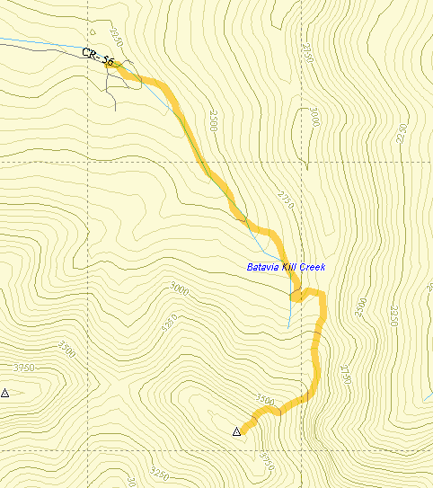
Park at the trailhead at the end of Big Hollow Road. Find the red-blazed Black Dome range Trail and hike .6 miles. At this point bear left on the yellow-blazed Batavia Kill trail. Follow this yellow trail for .9 miles where it meets the blue-blazed Escarpment Trail. Take a right and follow this trail for 1 mile until the junction with the yellow-blazed Blackhead Mountain Trail. This trail is EXTREMELY steep at times and rises about 1300 ft. in less than a mile. Be prepared to do some climbing up "stairs" and over rocks and roots. After the climb you will be at the summit of Blackhead Mountain. Stop to look around at the scenery on the way up since there isn't much of a view from the summit. Retrace your route to return to the parking area.
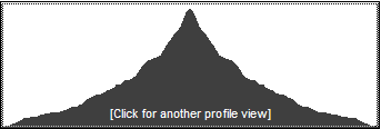
(The image above is the vertical profile for the hike starting at the Batavia Kill PA. This includes the trail up the east side of Blackhead and then back down to the PA.)
| Quick Look - Big Hollow from the West | ||||
|---|---|---|---|---|
| Difficulty | Round trip | Total climb | Location | Internet Maps |
| 4.5 mi. | 1922 ft. | N42 16.06 W74 06.32 | AllTrails | |
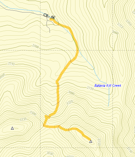
Park at the trailhead at the end of Big Hollow Road. Find the red-blazed Black Dome range Trail and hike .6 miles. At this point bear right to stay on the red trail. A yellow-blazed trail goes off to the left. After another 1.4 miles of ascent with switchbacks to make the climb "easier", you arrive at the Blackhead Mountain trail with only .65 miles to the summit. There is a rather steep ascent here over an open rock face. Make sure you have a good foothold and look back over your shoulder for a great view of Black Dome. The exposed rock that you see is where you will be shortly as you ascend that mountain. A more stable and equally fine view is available as you finish this short, steep climb. Retrace your route back down Blackhead to the col where you picked up the yellow trail. At this point retrace your route to the parking area.
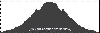
(The image above is the vertical profile for the hike starting at the Batavia Kill PA to Lockwood Gap, up Blackhead and back down.)
| Quick Look - Black Dome and Blackhead from Big Hollow | ||||
|---|---|---|---|---|
| Difficulty | Round trip | Total climb | Location | Internet Maps |
| 5.6 mi. | 2570 ft. | N42 16.25 W74 08.2 | AllTrails | |
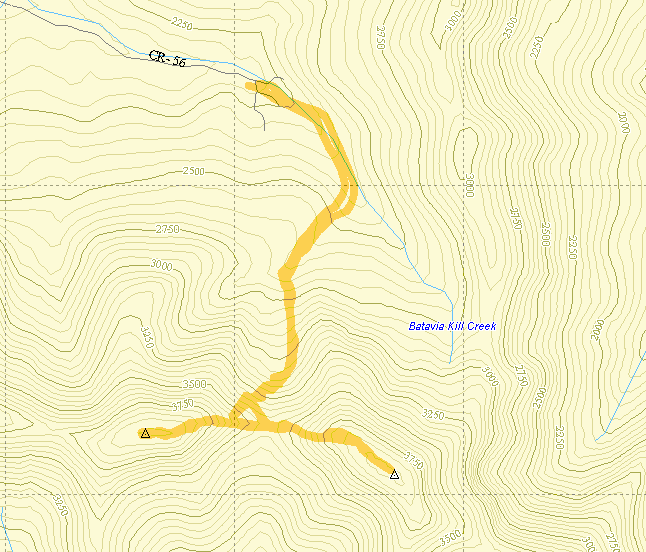
Park at the trailhead at the end of Big Hollow Road. Find the red-blazed Black Dome range Trail and hike .6 miles. At this point bear right to stay on the red trail. A yellow-blazed trail goes off to the left. After another 1.4 miles of ascent with switchbacks to make the climb "easier", you arrive at the Blackhead Mountain Trail. Turn left onto this trail and climb .65 miles to the summit. Once you reach the flat rock and trail junction that mark the summit, turn around and retrace your path back to the col. Continue straight ahead on the red Black Dome Range Trail for .6 miles to the summit of Black Dome Mountain. As you climb over the steepest rock scrambles, hold on and look over your shoulder to see Blackhead Mountain. From the summit of Black Dome retrace your route back to the col between Black Dome and Blackhead. Turn left to stay on the red trail and proceed back to the parking area.
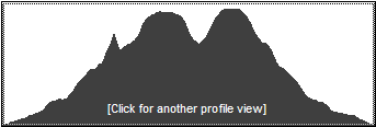
(The image above is the vertical profile for the hike starting at the Batavia Kill PA. This includes the trail to Lockwood Gap to the Col between Blackhead and Black Dome and then to the summit of Blackhead and then Black Dome.)
| Quick Look - Blackhead Range from Big Hollow | ||||
|---|---|---|---|---|
| Difficulty | Round trip | Total climb | Location | Internet Maps |
| 6.7 mi. | 2850 ft. | N42 16.06 W74 06.32 | AllTrails | |
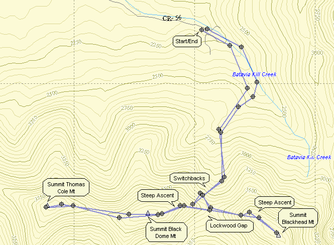
Park at the trailhead at the end of Big Hollow Road. Find the red-blazed Black Dome range Trail and hike .6 miles. At this point bear right to stay on the red trail. A yellow-blazed trail goes off to the left. After another 1.4 miles of ascent with switchbacks to make the climb "easier", you arrive at the Blackhead Mountain trail with only .65 miles to the summit. There is a rather steep ascent here over an open rock face. Make sure you have a good foothold and look back over your shoulder for a great view of Black Dome. The exposed rock that you see is where you will be shortly as you ascend that mountain. A more stable and equally fine view is available as you finish this short, steep climb. Retrace your route back down Blackhead to the col where you picked up the yellow trail. At this point you can simply retrace your route to the parking area if Blackhead was your only goal for the day. If you want to include the other two mountains, get back on the red trail and follow it for .6 miles to the summit of Black Dome. As you climb over the steepest rock scrambles, hold on and look over your shoulder. The exposed rock you see on Blackhead is where you were just a little while ago. From the summit of Black Dome you continue for another rather uneventful .8 miles to the summit of Thomas Cole Mountain. To return, retrace your route back to the col between Black Dome and Blackhead. Stay on the red trail and proceed back to the parking area.

| Quick Look - Loop from Big Hollow | ||||
|---|---|---|---|---|
| Difficulty | Round trip | Total climb | Location | Internet Maps |
| 4.5 mi. | 1840 ft. | N42 16.06 W74 06.32 | AllTrails | |
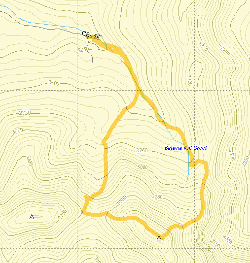
Park at the trailhead at the end of Big Hollow Road. Find the red-blazed Black Dome range Trail and hike .6 miles. At this point bear left on the yellow-blazed Batavia Kill trail. Follow this yellow trail for .9 miles where it meets the blue-blazed Escarpment Trail. Take a right and follow this trail for 1 mile until the junction with the yellow-blazed Blackhead Mountain Trail. This trail is EXTREMELY steep at times and rises about 1300 ft. in less than a mile. Be prepared to do some climbing up "stairs" and over rocks and roots. After the climb you will be at the summit of Blackhead Mountain. Stop to look around at the scenery on the way up since there isn't much of a view from the summit. Go right on the Blackhead Mountain Trail and descend .65 miles to the col between Blackhead and Black Dome. There are some nice viewpoints on the way down. In the Col turn right on the red-blazed Black Dome Range Trail and hike 2.0 miles back to the parking area.

(The image above is the vertical profile for the hike starting at the Batavia Kill PA up the east side of Blackhead to the summit. It then descends the west side to Lockwood Gap and proceeds back to the parking area. Of course, this loop can be reversed.)
| Quick Look - Blackhead Range Loop from Big Hollow (Blackhead first) | ||||
|---|---|---|---|---|
| Difficulty | Round trip | Total climb | Location | Internet Maps |
| 7.8 mi. | 2850 ft. | N42 16.06 W74 06.32 | AllTrails | |
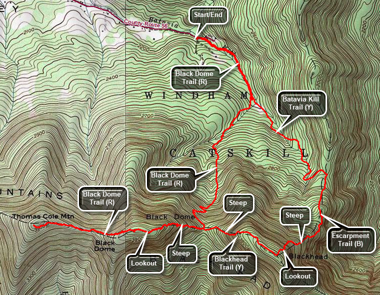
Park at the trailhead at the end of Big Hollow Road. Find the red-blazed Black Dome Range Trail and hike .6 miles. At this point bear left on the yellow-blazed Batavia Kill Trail. After another 1.1 miles turn right on the blue Escarpment Trail and get ready for an even steeper ascent. After ascending over 1000 feet in .85 miles, the trail comes to the summit of Blackhead Mountain. Turn left and walk a short distance to a lookout watching for some old inscriptions on the rocks. Turn around and return to the summit of Blackhead. Continue straight ahead on the yellow Blackhead Mountain Trail which briefly crosses the flat summit before descending steeply to Lockwood Gap. Watch for a lookout along the way. At Lockwood Gap you will have hiked 3.3 miles but it may seem longer. Continue straight ahead on the red Black Dome Trail which begins a short but steep .5 mile ascent to the summit of Black Dome Mountain. There are several possible lookouts along the way. Continue on the Black Dome Trail for another .8 miles to the summit of Thomas Cole. Compared to the trip so far, the section to Thomas Cole is tame. There is no view from the summit. Turn around and retrace your route back to Lockwood Gap. Turn left on the Black Dome trail and follow it for 1.9 miles back to the parking area.

| Quick Look - Blackhead Range Loop from Big Hollow (Black Dome first) | ||||
|---|---|---|---|---|
| Difficulty | Round trip | Total climb | Location | Internet Maps |
| 7.7 mi. | 2840 ft. | N42 16.06 W74 06.32 | AllTrails | |

Park at the trailhead at the end of Big Hollow Road. Find the red-blazed Black Dome Range Trail and hike .6 miles. At this point the yellow-blazed Batavia Kill Trail goes off to the left. Bear right to continue on the Black Dome Range Trail for 1.3 miles to Lockwood Gap. Turn right to stay on the Black Dome Range Trail and to start the steep climb up Black Dome. After .5 miles climbing a 19% grade you will pass the summit of Black Dome 2 miles into the hike. Watch for a lookout on the left of the trail. Continue on the Black Dome Range Trail for another .8 miles to the summit of Thomas Cole. Turn around and follow your route back down Thomas Cole, up and over Black Dome to Lock wood gap at 4.6 miles. Continue straight ahead on the yellow Blackhead Trail for .6 miles to the summit of Blackhead Mountain. This is the steepest climb on this route with short sections approaching a 30% grade. The trail levels at the top and the summit is at a big rock where the short Blackhead Trail meets the blue Escarpment Trail. You can walk a short distance to the right on the Escarpment Trail to find some old inscriptions in the rock. Continuing in this direction for another 1.3 miles brings you to Arizona, a particularly nice viewpoint. From the summit of Blackhead turn left and walk around the rocks and down the blue blazed Escarpment Trail. Down is the most important word as the trail drops 1070 feet in .8 miles averaging a 25% grade with one short section registering 40%. At 6 miles into the hike, turn left on the yellow Batavia Kill Trail which continues to descend for a mile back to the Black Dome Range Trail at a more reasonable grade. At 7 miles turn right on the Black Dome Range Trail and retrace your steps earlier back to the car.

| Quick Look - Blackhead Black Dome Loop from Big Hollow | ||||
|---|---|---|---|---|
| Difficulty | Round trip | Total climb | Location | Internet Maps |
| 6.2 mi. | 2300 ft. | N42 16.06 W74 06.32 | AllTrails | |
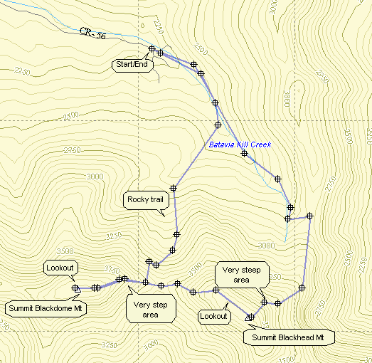
A variation of the above route is possible. Park at the trailhead at the end of Big Hollow Road. Find the red-blazed Black Dome range Trail and hike .6 miles. At this point bear left on the yellow-blazed Batavia Kill trail. Follow this yellow trail for .9 miles where it meets the blue-blazed Escarpment Trail. Take a right and follow this trail for 1 mile until the junction with the yellow-blazed Blackhead Mountain Trail. This trail is EXTREMELY steep at times and rises about 1300 ft. in less than a mile. Be prepared to do some climbing up "stairs" and over rocks and roots. After the climb you will be at the summit of Blackhead Mountain. Go right on the Blackhead Mountain Trail and descend .65 miles to the col between Blackhead and Black Dome. There are some nice viewpoints on the way down. See the route above for the remaining possibilities.

(The image above is the vertical profile for the entire hike starting at the Batavia Kill PA. This includes the trail up the east side of Blackhead and down into Lockwood gap. It then proceeds up Black Dome before returning the same way to the Gap and then back to the PA.)
| Quick Look - Blackhead Range from Barnum Road | ||||
|---|---|---|---|---|
| Difficulty | Round trip | Total climb | Location | Internet Maps |
| 8.6 mi. | 2920 ft. | N42 16.25 W74 08.2 | AllTrails | |
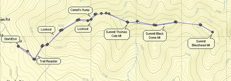
Park at the trailhead on Barnum Road of the Maplecrest Road. Find the red-blazed Black Dome Range Trail that follows an old road for about .45 miles. Turn left off the road and register for the hike. Follow the red trail which climbs steadily for 1.6 miles over two hills named Caudal and Camel's Hump. Some believe that Camel's Hump should be surveyed again as it appears to be over 3500 feet and far enough away from Thomas Cole to be considered a new 35. On the way up the Caudal there is a lookout off the trail to the right. It offers some nice views to the south. Some parts of this trail are steep while others have switchbacks to help keep the climb manageable. Near the top of the Camel's Hump is another more popular lookout to the right. This also offers views to the south but they are more extensive. Continue on the red trail for another .85 miles to the summit of Thomas Cole Mountain. The descent from Camel's Hump into the col is not very difficult. There are very few views along the way. At one point as you walk along the flat area in the col between the Hump and Cole, Thomas Cole Mountain is directly in front of you. The final ascent up Thomas Cole is steep in parts and rather long. There are no views from the summit.
Continue on the red trail for .8 miles to the summit of Black Dome. The descent into the Col and subsequent ascent of Black Dome are both steep and you will repeat them as you retrace your steps back to the parking area! Just before the summit on Black Dome is another lookout again to the south. Continue on this trail for 1.25 miles passing through the col on the way to Blackhead Mountain. The summit of Blackhead as no views but as you ascend the western flank of Blackhead there are great views back to the west at Black Dome. After reaching the rock and trail junction that mark the summit, turn around and retrace your path back to the parking area.
| Quick Look - Windham High Peak and Blackhead from Big Hollow | ||||
|---|---|---|---|---|
| Difficulty | Round trip | Total climb | Internet Maps | |
| 10.8 mi. | 3400 ft. | AllTrails | ||
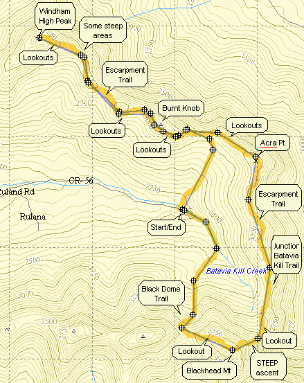
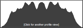
From Rt. 23C take Maplecrest Road north to Maplecrest and then turn right onto Big Hollow Rd. Go to the "end" of Big Hollow Road and park in the parking area on the right. You may also use the snow plow turn around on the left when there is no snow. On the left side of the road find the trail head for the red-blazed Black Dome Trail. The first water crossing across Batavia Kill is on a bridge so there is no problem. Right after the bridge and trail register you must cross a small tributary which can be all but impossible during high water. If you cannot cross here, you may be able to bushwhack along the left side of the stream to an easier crossing. After about a mile the Black Dome Trail ends at a T with the blue-blazed Escarpment Trail. Turn left toward Burnt Knob and Windham High Peak. The climb up Burnt Knob is short but can be tricky. In the winter the narrow trail is hard to negotiate with snow shoes. In the drier seasons the loose dirt in some areas makes falling very easy. After about .25 miles there is a side trail to the left which offers a beautiful view of the Blackhead Range to the south. Back on the main trail you will begin to descend from Burnt Knob in only .1 miles. There is a view of Windham just as you begin to descend. The view is much better when there are no leaves on the trees. After about 1.5 miles of most flat walking the climb up Windham begins. There are several spots along the way that offer views; some better than others. One spot in particular is about halfway between Burnt Knob and Windham. Walk off the trail to the right and a rock ledge offers wonderful views to the north and east. The climb up Windham gets steeper at times but a few switchbacks help out. The distance is less than a mile and Windham is only 3524 ft. in elevation. As you near the top there are two nice lookouts on the right. Continue on to a big pine tree near the top that marks the highest spot on the peak. Retrace your steps to the lookouts and enjoy the view. To get back to the junction with the Black Dome Trail just reverse your course and return the way you came. At the trail junction continue straight ahead on the Escarpment Trail as it ascends Acra Point. There are some nice views of the valley from lookouts on Acra Point. At 7.9 miles into the hike the Batavia Kill Trail departs to the right. Stay on the Escarpment Trail by continuing straight ahead and get ready for the most challenging climb of the hike up the east side of Blackhead. This part of the Escarpment Trail begins to ascend almost immediately and although it does level out after the first ascent it then becomes VERY STEEP. It rises around 1300 feet in less than one mile. At 8.6 miles you will be at the open rock that marks the summit of Blackhead. Signs here indicate that the Escarpment Trail goes to the left. Turn right on the Blackhead Trail which takes you across the summit plateau and then down to Lockwood Gap. Along the way there are some lookouts which have nice views of Black Dome. At the trail junction in Lockwood Gap turn right to take the Black Dome Trail back to the parking area. The walk back to the car is about 1.6 miles but it is all downhill dropping over 1200 feet!
| Quick Look - Blackhead from Colgate Lake | ||||
|---|---|---|---|---|
| Difficulty | Round trip | Total climb | Internet Maps | |
| 13.8 mi. | 2650 ft. | AllTrails | ||
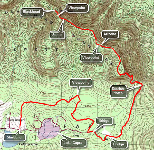
From Route 23A in Tannersville head north on County Route 23C. The road ascends to a stone chapel at the top. The views of the Devil's Path from the stone chapel are worth a quick stop. As you drive down the other side of the hill from the chapel, watch for Colgate Road which is also marked as County Route 78 on the right. Turn right and drive 1.7 miles to the parking area for the hike on the left. The parking area is just passed Colgate Lake which is on the right. From the parking area there are some nice views of Blackhead in the distance. Walked out the end of the parking area to cross a field before walking into the woods. The initial part of the trail is largely an old woods road. The trail follows this road but is somewhat circuitous to avoid the private inholding of Lake Capra. The road connected the fertile Jewett Valley with the markets on the east side of the Escarpment by passing through a gap called Dutcher's Notch. The first bridge is at 1.25 miles followed by a second at 2.0 miles. Just after the 2 mile mark the trail is often very wet with standing water and mud. It is possible to avoid walking through much of it by staying on the sides of the trail or taking a slight detour. At about 2.3 miles there is an evergreen forest and a large beaver meadow on the left with nice views of the Escarpment, Arizona and the Blackhead Range. At 2.5 miles there is a third bridge over the East kill or one of its smaller tributaries. There is a beaver pond on the left of the trail on the other side of the bridge. Shortly after this there is a fourth bridge made up of two logs after which the trail takes a sharp right onto an old road. A field on the left offers some more great views of the Blackhead Range. A little farther along there is a small falls on the right of the trail. The trail/road here was a lot of rocks making the walk a little tricky. For the next 1.5 miles the trail ascends toward Dutcher Notch and begins to climb a little more seriously. In many places high stone cliffs rise on either side. In other places there is a deep gorge on the left side of the trail. After 4.25 miles there is a junction with the Escarpment Trail. Turn left and start to gain some real elevation on the climb to Arizona. There are some beautiful views, several switchbacks and a few scrambles up and over rocks. There was even a "tunnel" in one spot. When you reach the plateau near the top, there are nice lookouts at the 5 mile mark. Lake Capra is visible just below the viewpoint and on a nice day the Hudson can be seen. For the next .8 miles there is about a 300 foot elevation gain as the trail follows the narrow spine of the escarpment and the Blackhead Range. After this there is a drop of over a 100 feet and then a gentle climb up toward Blackhead for .75 miles. At this point the climb begins to get steep all the way to the summit of the mountain. For the next half mile there is a gain of 500 feet. There are two areas before the summit that look remarkably like the top but are "false summits". The second has the legend "Camp Steel 1936" painted in white on the rocks. Once you are at the true summit there isn't much to see. To complete the hike turn around and follow the same route back to the car.
