
West Hudson Trails
Besides the thirty-five 3500 foot peaks in the Catskills, there are many other smaller mountains to climb. In addition, there are hundreds of miles of trails to hike. There are also MANY other places to hike also. I have divided the Trails section into list of All Trail, the Catskills, the Shawangunks, Bear Mt/Harriman, East Hudson, West Hudson, New Jersey and Other Trails. The All Trails list includes over 400 different trails and may load slowly on your computer. The "divided" list should load more quickly.
You can view all the West Hudson Trails here.
Clicking on ![]() will bring up an index of trails. Clicking on
will bring up an index of trails. Clicking on ![]() will return you to the top of the page.
will return you to the top of the page.
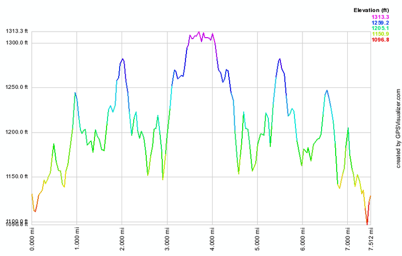
Bellvale Mt: Mt Peter to Bellvale Mt
| Quick Look | |||||
|---|---|---|---|---|---|
| Difficulty | Round trip | Total climb | Internet Maps | ||
| 7.5 mi. | 987 ft. | AllTrails | |||
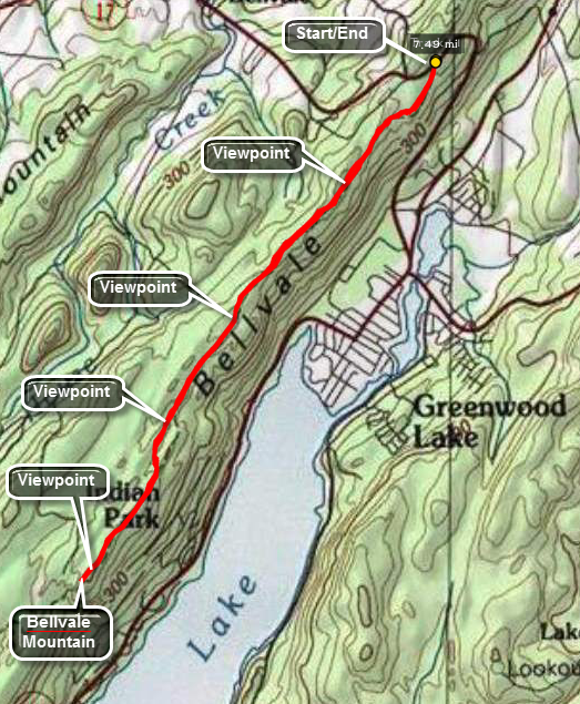 To park for this hike travel on Route 17A from Warwick to Greenwood Lake or vice versa. A little less than two miles north of the intersection of Routes 17A and 210 in Greenwood Lake there is a pulloff at the top of the hill on the south side near some rundown buildings. Park here but watch for broken glass! You may also see the white signs or blazes fro the AT as it crosses the road here. Find the trail and start to walk southwest on the AT. This route starts at Mt. Peter near Warwick, NY and travels southwest paralleling Greenwood Lake. The ridge is rugged but the elevation profile accentuates the small ups and downs and makes it look far worse than it is. It part of the AT that runs along Bellvale Ridge until it gets to Bellvale Mountain. Through hikers on the AT are often found here during the summer. There are at lead four good viewpoints along the ridge that look east and south across Greenwood Lake. Bellvale Mountain is a good point for the hiker without a car spot to turn around and hike back to the car. You may continue on the trail down a steep descent and go as far as you like. One objective would be a hike around Surprise Lake but this will add over 5 miles to the hike!
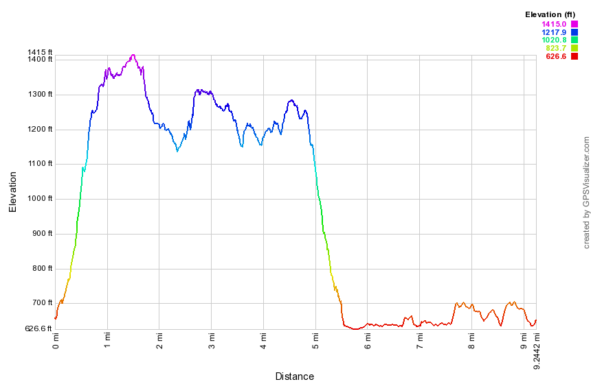
Bellvale Mt: NYNJ Border to Village Vista
| Quick Look | |||||
|---|---|---|---|---|---|
| Difficulty | Round trip | Total climb | Internet Maps | ||
| 9.3 mi. | 1670 ft. | AllTRails | |||
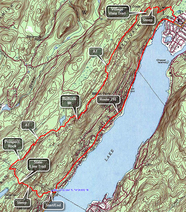 To park for this hike travel on Route 17A from Warwick to Greenwood Lake. At the bottom of the hill stay right on Route 210 through the village of Greenwood Lake. Route 210 travels along the west shore of the lake and heads toward New Jersey. Watch for a sign that says "Welcome to New Milford Township". Just before the sign turn up the driveway to the trailhead parking. Try to park so that you do not block any of the boats from the marina that shoes the parking area. Head out on the blue State Line Trail which seems to be quite popular as the ground is well-packed. In addition, people have walked off the trail wherever they want which makes the main trail hard to follow. The trail blazes can also be confusing so watch the paint very carefully. After wandering along the base of the ridge to the west for about a quarter of a mile the trail turns right or northwest and starts up the ridge. Although there are some switchbacks along the way, there are also some steep sections. The sidetracks continue to be a problem as are the faded blazes. Some parts of the trail are packed dirt but there are several sections with a lot of rocks which makes walking harder. Over the next .8 miles you will gain 650 feet to the top of the ridge. At the top of the ridge an SL sign is painted on the rocks. Turn right to get on the AT and head northeast. At 1.5 miles, you will ascend to Prospect Rock which has a flag on top. Prospect Rock is the highest point on the AT in New York state. Continue on your way from the top of Prospect Rock as the trail descends for the next .9 miles. Sometimes you will be walking along the knife edge of rock outcrops while other times you will be in the shade of pine trees with over soft, marshy ground. At 2.4 miles begin to ascend Bellvale Mountain. The ascent is .4 miles and gains about 200 feet. Along the way you will encounter several rock scrambles. One ascent is nearly vertical and has an aluminum ladder tethered to the rock face. If you are hiking with a dog, I can only tell you that Sheila made it with no problem! At the top of the climb you will be on Bellvale Mountain. Continue along the ridge as the trail repeatedly descends and ascends with open rock faces and dark stretches through the evergreens. Some ascents are steep although brief. There are several large rock cairns along the way. After a little more than 2 miles you will arrive at the Village Vista trail 4.9 miles into the hike. Turn right onto the Village Vista which starts out almost level but changes immediately as it begins to descend to the lake. There were several switchbacks but the grade is still challenging and would be more so on the ascent. The "vista" is disappointing as most of the view is blocked by trees. Continue down the trail from the vista as it become steeper and rockier. Where the trail is not rocky it can be dusty which makes getting a good grip difficult. You will eventually break out into a sand and gravel yard almost at the bottom of the ridge. The trail turns left onto a road but then immediately turns right turned back into the woods briefly until it comes out onto some local streets. you will be about 5.7 miles into the hike. Follow the streets out to Route 210. which has pretty good shoulder for walking. Route 210 is flat and level compared to the ridge with only few hills that are easily negotiated. The house numbers decrease as you approach the state border. After walking another 3.6 miles, the sign for the marina will come into view. Turn right to walk up to the car.
Black Rock Forest: Complete Loop
| Quick Look | ||||
|---|---|---|---|---|
| Difficulty | Round trip | Total climb | Internet Maps | |
 |
10.4 mi. | 2267 ft. | AllTrails | |
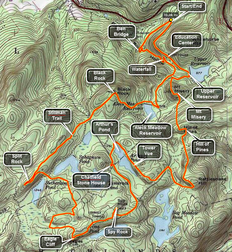 From the south, get on Route 9W on the west side of the Hudson River heading north from West Point toward Newburg. From the junction with Route 293 near the Unites States Military Academy at West Point, drive 3.5 miles north on 9W. Look for Mountain Road and the Storm King School on your right. Turn onto Mountain Road and immediately make an almost 180 degree turn into the tunnel that passes back underneath Route 9W. Use CAUTION since the tunnel is VERY NARROW! Only one car can pass through at a time. Continue straight ahead on Reservoir Road until you get to the parking area on your right.
From the north, get on Route 9W south from Newburgh to West Point. From the junction with Interstate 84 in Newburgh , drive 8.5 miles south on 9W. Look for Old West Point Road on your right. Turn right onto Old West Point Road and follow it to the junction with Reservoir Road. Turn right and continue straight ahead on Reservoir Road until you get to the parking area on your right.
The trail and route description below are representative of the MANY variations you can use in this area. A combination of trails, woods roads and roads give the hiker an opportunity to custom tailor an outing.
Find the trailhead with maps and an overview of the area. Get on the red Duggan Trail and walk about .5 miles until it meets the blue Reservoir Trail. Turn left here and cross Ben's Bridge over the stream that is the outlet for the Upper Reservoir. Follow this trail for about .5 miles as it parallels the brook and climbs to the area near the Education Center. Passed the center the yellow trail begins to climb Mount Misery. Bear right onto White Oak Road and follow it .5 miles to the Aleck Meadow Reservoir. At the reservoir turn right and walk along the shore and across a small bridge just below the spillway. At this point you will be on the yellow Stillman Trail.
Follow the Stillman Trail for .5 miles as it ascends Black Rock. Follow the Stillman Trail for about .4 miles at which you will come to a confusing intersection of roads and trails with two separate gates. Stay on the Stillman Trail by passing through the first and second gates. Just after the second gate turn right. Continue on the Stillman Trail for 1.35 miles and watch for a white trail on the left. This is the Split Rock Trail. Turn left an follow this trail for .3 miles until it meets the Sutherland Road which travels in and east-west direction. Continue walking straight ahead on the Chatfield Road between the two ponds. After only about .15 miles turn right on the yellow Secor Trail. This trail joins with the blue Chatfield Trail in only about .25 miles.
Turn right on the Chatfield Trail and walk .3 miles to the white Scenic Trail. Stay on the Scenic Trail for .25 miles and watch for the blue Eagle Cliff Spur trail on the right. Walk a few hundred feet out to Eagle Cliff. Get on the red Rut Trail and walk .15 miles to the yellow Stropel Trail. Turn left and walk a few hundred feet back to the white Scenic Trail. Continue on this trail for .35 miles to the blue Spy Rock Spur Trail on the left. Walk a few hundred feet up to Spy Rock, look around and return. Walk for about .25 miles and turn left on Continental Road. About .5 miles up the Continental Road is the Chatfield Stone House. From here continue .1 miles on the road and turn right on the while White Oak Trail to the shores of Arthur's Pond.
Continue .15 miles across the outlet of Arthur's Pond and up a short hill to the yellow Tower Vue trail. Turn right here and walk .55 miles along the shore of the pond and back to the white Scenic Trail. Turn left and continue .2 miles on the trail which is also Bog Meadow road a this point. Turn right into the woods following the white Scenic trail as it heads south and the loops north and northeast again. After .5 miles and some climbing you will be at the top of Rattlesnake Hill. In another .7 miles you will crest Hill of Pines. After about .25 miles more you will cross the blue Swamp Trail and in only a few hundred feet the white Scenic trail ends at a junction with the yellow Stillman Trail. Turn right here to ascend .15 miles to the top of Mount Misery.
Descend .15 miles down Mount Misery and turn right on White Oak Road. In .17 miles you will be at the upper Reservoir. Turn left on Reservoir Road and walk .25 miles down to the Education Center. Another easy .55 miles on the road delivers you back to your car in the parking area.
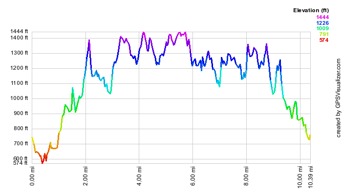
(The image at the left shows the profile of the hike. Remember that all vertical profiles are relative!)
Black Rock Forest: Black Rock Hollow Loop
| Quick Look | ||||
|---|---|---|---|---|
| Difficulty | Round trip | Total climb | Internet Maps | |
| 5.8 mi. | 1180 ft. | AllTrails | ||
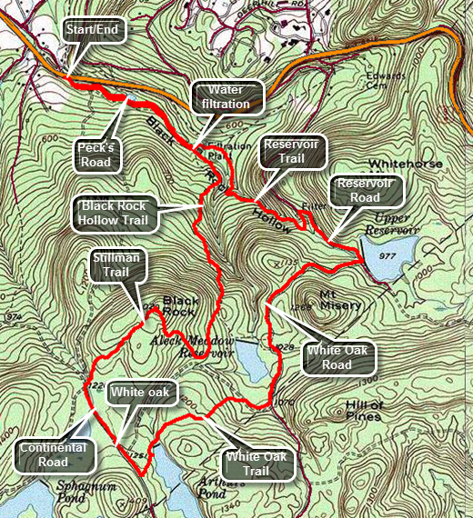 Black Rock Forest has many trails and roads. A map is essential to being able to navigate your way around this interesting but confusing maze. From the south, get on Route 9W on the west side of the Hudson River heading north from West Point toward Newburg. From the junction with Route 293 near the Unites States Military Academy at West Point, drive a little more than 4 miles north on 9W. Look for Mountain Road and the Storm King School on your right. The parking area is on the west side of the road about .7 miles passed the school. From the north, get on Route 9W on the west side of the Hudson River heading south toward West Point. From I84 it is just less than 8 miles to the parking area on the west side of Route 9W. The parking area is about a mile south of Angola Road. Pull over and park in the lot and start out on Peck's Road which has a gravel surface and is in great shape. For the first .6 miles stay on the road which has a very gradual uphill grade. When you reach the water filtration plant, the Black Rock Hollow Trail turns right off the road into the woods following and old woods road. The woods road is rocky and eroded in places but the trail is sited to avoid the worst spots. Over the next .9 miles gain almost 600 feet along a 12% grade with some steeper sections. At 1.5 miles there is a junction with the yellow Stillman Trail. Turn right to head toward Black Rock. Continue following the Stillman Trail northwest toward Black Rock. By the time you hit the highest point on Black Rock you will have gained another 260 feet in the .3 miles from the trail junction. The view from Black Rock is more than 180 degrees to the south, west and north. Look southwest or to the left to see a fire tower which is just a shell and closed to the public. To the northwest the Schunnemunk Ridge is prominent and with the Moodna Viaduct just below it. The viaduct was opened in 1909 and is still the longest and highest railroad trestle east of the Mississippi River! To the north is the Hudson River and the Newburgh-Beacon Bridge. Follow the Stillman Trail as it makes a steep descent and watch for the black deposits that give the rock its name. The descent isn't long but the first part is very steep. I have done this in the winter and spikes are almost a must if there is any ice or snow. At 2.3 miles turn left onto Continental Road and hike along the well groomed surface until you reach a large white oak tree at 2.6 miles. This tree seems to be in pretty good condition. Continue on a few hundred feet and turn left the white blazed White Oak Trail to Arthur's Pond. Continue on the trail as it crosses just below the spillway of the pond. After crossing the spillway, follow the White Oak Trail as it heads into the woods to the left. The trail comes to an end on White Oak Road. Turn right on the road and follow it as it passed along the shore of Aleck Meadow Reservoir. Continue to follow the road as it passes Aleck Meadow Reservoir and heads toward the Upper Reservoir. At the Upper Reservoir continue on Reservoir Road to the Mailey's Mill Bridge near the research center. At 4.5 miles turn left and cross over the bridge to the blue Reservoir Trail. The stream on the right once powered the mill. Continue on the trail crossing the stream on Ben's Bridge until the trail ends at the water filtration plant at 5.25 miles. Turn right on Peck's Road. From there it is only .6 miles downhill to the car.
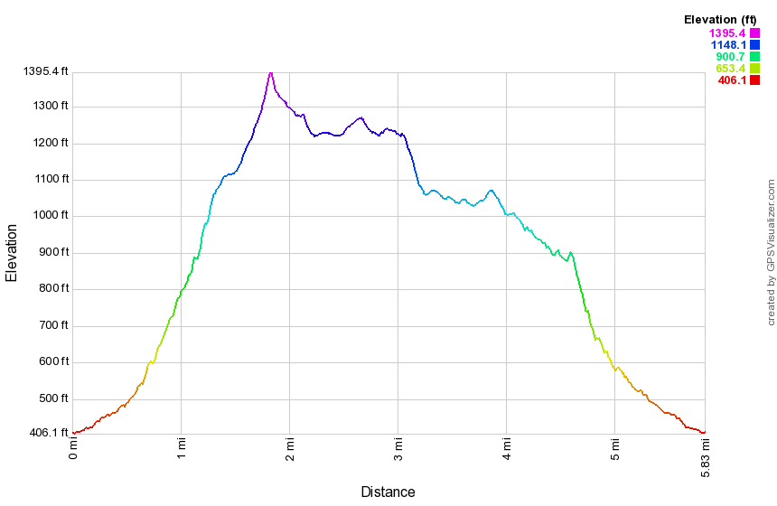
(The image at the left shows the profile of the hike. Remember that all vertical profiles are relative!)
Fort Lee to New York Border
| Quick Look | |||
|---|---|---|---|
| Difficulty | Round trip | Total climb | Internet Maps |
| 13.5 mi. | 1265 ft. | AllTrails | |
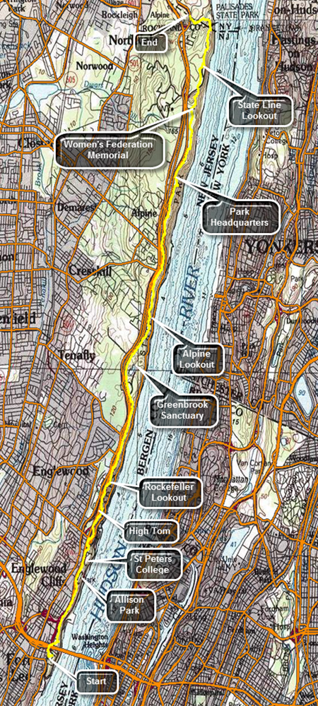
This hike is 13.5 miles ONE WAY. Unless you feel you can cover 27 miles, you will need to arrange a car spot or a ride.Take exit 11, Nyack, off the NYS Thruway. After getting off the exit turn left on Route 59 and then right on Route 9W not far down the road. Head south on Route 9W passing through Palisades and turning left onto Ludlow Lane at the state border. Park on the shoulder of Route 9W just north of the bus stop as far off into the grass as possible. Call a car service for a ride to Fort Lee or drive another car to Fort Lee Historical Park to start the hike. The easiest route is to get on the Palisades Parkway just south of where you are parked. Get off at exit one and take Route 505 south. The entrance to Fort Lee Historical Park is on the left after you pass under I95. The first part of the trail goes out to Route 505 where it heads north and passes under I95. Right after this it goes up a set of stairs on the right and then crosses another road on a pedestrian bridge. From here the Long Path passes through a wooded strip of land that is for the most part sandwiched between the Palisades Parkway on the west and the escarpment and Hudson River on the east. At about .5 miles there is a side trail that goes out to a viewpoint which is the first of many you will encounter. The George Washington Bridge and the city skyline are prominent from this lookout. Walk a little farther and there is another lookout. At the base of the cliff there is what looks like a park and the views of the Palisades cliffs are impressive. This general pattern repeats itself many times throughout the hike. At .8 miles blue and white trail blazes mark the Carpenter's Trail to the right that leads to the Shore Trail. At about 1.6 miles there is an iron fence ahead of us and the Long Path blazes turn to the left around Allison Park. Walk passed the entrance to the park, along the access road and then on a narrow strip of land near the parkway. Walk in front of St. Peter's College at about 2.1 miles. After passing the college, there is another viewpoint. At 2.5 miles descend some steps to East Palisades Avenue, turned right and then almost immediately left to cross the road. The aqua blazes go up some steps and then onto the trail along the edge of the cliffs. There are again nice views to the east side of the Hudson. At about 3.1 miles the Long Path turns left but there is a nice viewpoint straight ahead. Walked on an unmarked trail to the top of High Tom for some great views. Continue on the Long Path to some more great views at about 3.5 miles at the Rockefeller Lookout. At 4.6 mils there is another lookout at Clinton Point opposite East Clinton Avenue. After another viewpoint, there is a chain link fence a fence at 5.1 miles. Walk along the fence until you cross a stream and a road at 5.4 miles. There is a gate in the fence which surrounds Greenbrook Sanctuary which is a private sanctuary that preserves areas of forest and habitats that were once common in the area. Continue on the Long Path dipping twice to cross streams. At 6.25 miles a red trail, the Huyler's Landing Trail leaves the Long Path to the right and heads down to the Shore Path. Continue straight ahead on the Long Path which again runs along the cliffs. At about 6.75 miles reach the Alpine Lookout which has several different viewpoints. The largest one is near the top of a short hill with views up and down the river. Continue along a stone wall and then enter the woods again. The trail is on an old paved surface again and passes by several stone walls and some foundations. Continue walking along the trail with the parkway on the left and glimpses of the cliffs and river on the right. At 8.35 miles descend a hill to the Alpine Access Road bordered by a stone wall. The trail turns right and passed through a tunnel under the road. On the other side the trail begins to ascend a very rocky trail as it heads toward the headquarters for the New Jersey section of the Palisades Interstate Park. The trail continues at the far end of the parking area and passes through hardwood and evergreen forests. At 9.3 miles there is a path to the right which has a short bridge out to a rock outcrop. Walk across the bridge and out onto the rocks for some more nice views of the river. Over the next mile or so the trail follows some dirt and gravel roads while other paths cross the trail. Watch the aqua blazes carefully and you will have no trouble staying on the Long Path. At 10.7 miles there is a clearing with a small "castle". This is a monument to the New Jersey Federation of Women's Clubs which played a big part in preserving lands on the Palisades. The monument also has another good lookout. Climb the stairs to the top of the monument if you like although there are no better views from the top. Continue on the Long Path by descending some stone steps. Pass a blue and white trail, the Forest View Trail which descends to the Shore Trail. At 11.2 miles cross the access road to the State Line Lookout. There are many ski trails in the area but the aqua blazes are always very prominent. Continue to follow the blazes until at 11.7 miles and you will be behind the State Line Lookout snack bar. The trail turns left here but walk out to this very large viewpoint. Walk back to the trail and follow it as it winds its way back to the old access road. Walk along the road until the trail turns to the right into the woods again. At 12.4 miles there is a chain link fence that marks the state border. The Long Path turns right here and begins to descend a set of stone steps which are steep at times. Turn left and pass through a gate into New York continuing to descend on the steps. At 12.8 miles the descent ends and you cross a small stream on a bridge. A white trail to the right leads down to the Peanut Leap Cascade and the remnants of Lawrence Gardens. Continue on the trail which can be wet at times in these lower spots. The trail heads up a hill and soon meets Ludlow Lane. Walk back to your car on Route 9W.
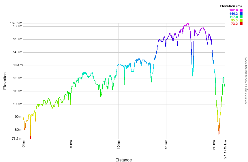 (The image at the left shows the profile of the hike. Remember that all vertical profiles are relative!)
Heritage Trail
| Quick Look | |||
|---|---|---|---|
| Difficulty | Round trip | Total climb | Internet Maps |
| 11.6 mi. | 360 ft. | AllTrails | |
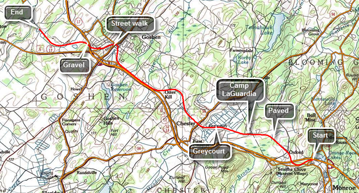 This route is a one way hike from east to west. This requires a you to spot a car at the end or get a ride. The 23.2 mile roundtrip would be difficult.Take the Fletcher Street exit, exit 126, off Route 17 heading east. Turn right and right again onto Cheechunk Road. Drive about 1.7 miles west to Hartley Road. Turn left and park at the Heritage Trail pulloff only a few hundred feet in on the right. Drop a car here. Drive back out to Route 17 and take exit 129. Park in the Heritage Trail parking lot on the right before the large commuter lots on the left. The trail starting in Monroe is a hard paved surface which makes walking it very easy. Throughout the walk you will meet other people who are walking and running some with their dogs. You will also meet people on bicycles. Everyone seems very respectful of the other people using the trail and many use it several times a week. Within .75 miles the trail passes under Route 17. Shortly after that there is a small cemetery nestled between the trees on the right side of the trail. It acts as a reminder that this area of Orange County has been settled for some time. There isn't much indication that the trail was once a railroad bed except where the trail crossed over another road. In several, places the tracks and original bridge are still intact. At about 1 mile the farmlands begin and you can catch glimpses of the countryside through the trees. You can still hear the noise of traffic but the atmosphere is very rural. Around 2.5 miles the trail passes by Camp Laguardia but most of the building are hidden by the high bank on the left side of the trail. There is also some fencing at various points along the route. Around 3.8 miles you will see the flat open fields of a black dirt region on the right or north of the trail. Just before the trail enters the village of Chester there is a railroad siding at Greycourt. A signboard tells the history of the area. As you enter Chester, there is an old railroad station on the left. The next section of trail is a little more than 4 miles and ends in Goshen. There is a lot of farmland on both sides of the trail. There are also three different marble benches dedicated to various people along the way. Where the trail crosses several roads traffic usually stops for pedestrians in the cross walk. There is even a portable toilet at one intersection. The village of Goshen is 8.5 miles from Monroe. Turned right on St. James Place and then left onto South Church Street. Continue on South Church and turn left on West Main after crossing Route 207. Keep looking for the aqua blazes on poles and signs. About .5 miles from South Church there is a large cemetery and the turn to the left is clearly marked with aqua blazes. Followed the blazes across the street and down a lane to the beginning of the last section of the Heritage Trail. From the village of Goshen to its end on Hartley Road, the trail is "paved" with crushed stone or it is simply packed earth. There are fewer people using this section. Pass under Route 17 at about 9.65 miles and continue on the flat, straight section. The predominant view on either side of the trail is a series of ponds and wetlands. There is one sign indicating that the Audubon Society maintains a bird sanctuary in the area. There is one final bench near the bird sanctuary with no dedication. After this it is a quick walk to Hartley Road.
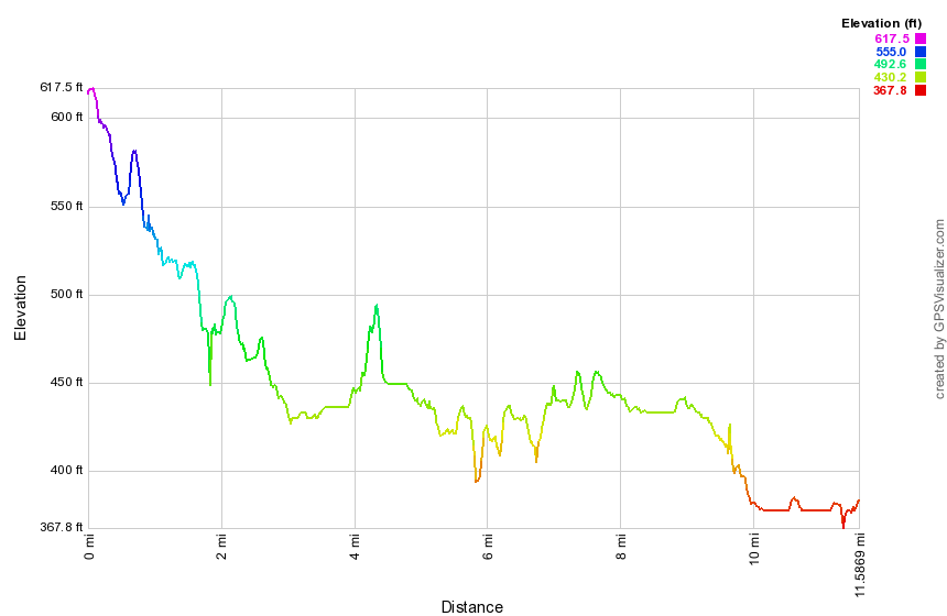 (The image shows the profile of the hike. Remember that all vertical profiles are relative!)
Landing Road to High Tor
| Quick Look | |||
|---|---|---|---|
| Difficulty | Round trip | Total climb | Internet Maps |
| 12.0 mi. | 2610 ft. | AllTrails | |
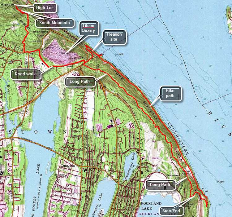
Take exit 12, Palisades Center, off the NYS Thruway. After getting off the exit watch for signs for Route 303 north. Watch for Lake Road on the right at a stop light. Turn right and followed Lake Road to Route 9W. Cross 9W to pick up Rockland Lake Road and drive around the southern tip of the lake and north along the eastern shore. At the intersection with Landing Road turn right onto Landing Road and park in the small lot. Look for the aqua blazes of the Long path on the north side of the parking area. The trail immediately begins a climb from the parking area as it passes by the Wells Family Cemetery. Within about .25 miles there is a high point but the trail immediately starts down the other side. This pattern continues all along the ridge. Along the ridge you may find a few limited viewpoints shown on some maps and mentioned in some trail description. Almost all of these points are now obscured by trees. You may try walking off the trail to find lookouts but it may be best to wait for High Tor! At 2.7 miles the trail hits the highest point on the ridge and starts down toward Lost Clove and Route 9W. On the way down there is a white blazed trail called the Treason Trail on the right. Descend to Route 9W where there is a small parking area. Straight across Route 9W is Lost Clove Road which is closed to traffic for some distance. Cross Route 9W and hike on Lost Clove Road passing the Tilcon Quarry on the right. The basalt that makes up most of the Palisades has been quarried here since 1920 and the operation is huge. Soon Last Clove Road becomes open to traffic and the Long Path then turns right on Scratchup Road to get to Old Route 303 or the Haverstraw Road. Turn left on Old Route 303 and start hiking west being very careful as the road has almost no shoulder and there can be a lot of traffic. Hike for about a quarter mile until the blazes indicate a right turn into the woods to begin the assault on High Tor. The trail is very rocky and poorly blazed in a few spots. After an initial climb the trail levels a little and then starts a gentle ascent passing a house on the left as it makes its way up toward the ridge. Hike almost directly north and at 5 miles descend a little to the junction with the spur trail to the left to High Tor Vineyards. Continued a little farther north and then follow the trail as it turns northwest to start the ascent up what is sometimes called South Mountain. You can chose to ascend through a rock scramble to the very top or follow the blazes of the Long Path around to the south side for an easier route. Follow the blazes to the final climb to the top of High Tor. The trail climbs the south side of the tor to the top with good views in all directions. From the summit the Hudson is just below with the village of Haverstarw at the base of the tor. To the south is Deforest Lake in the foreground with several other lakes further away including Rockland Lake. When you are ready, head back the way you came. Follow the trail back to Old Route 303 and from there walk back to Route 9W. You may now hike back over the Hook Mountain ridge or walk down to the bike path along the Hudson. Walk through the gate and follow the path to the left down to the railroad tracks. Carefully cross the tracks and watch for a path leading down to the bike path that runs along the river from Haverstraw to Nyack. Once on the bike path turn right to walk south to your car. Within a short distance there is a sign marking the spot where Benedict Arnold and John Andre discussed the betrayal of the fort at West Point. A little farther along there is a tunnel to the right that allows the trains to pass under the Hook Mountain ridge. At 8.3 miles there are some ruins down near the water. Walk down a path to the shores of the Hudson. The ruins aren't very old and aren't very interesting. All along the entire bike path are small stone buildings which look like they may have been bathhouses or restrooms. You may walk to the waters edge where you will be almost at sea level. When you are done, walking back up to the bike path and turn left to head south again. The path actually rolls some unlike the southern portion which is very flat. Eventually you will walk up a little hill a junction. Turning to the left takes you to Nyack. Turn right and follow the paved road up the hill and back to the parking area.
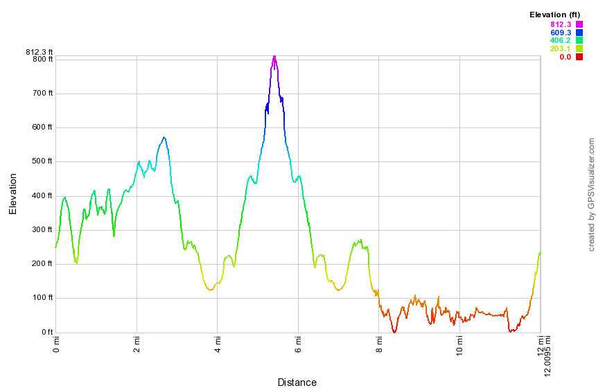 (The image at the left shows the profile of the hike. Remember that all vertical profiles are relative!)
Mount Ivy to Route 106
| Quick Look | |||
|---|---|---|---|
| Difficulty | Round trip | Total climb | Internet Maps |
| 7.5 mi. | 1630 ft. | AllTrails | |
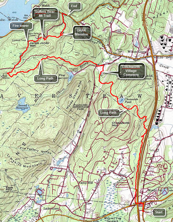
Note: This hike is best done with a car spot as the round trip would be 15 miles over difficult trails.Take the Palisades Parkway to Exit 15 and turn left onto Route 106. Drive to the junction with Route 98 and turn right. The parking area is a short distance up the road on the left. Park one car here. Drive back out to the Palisades Parkway South and take exit 13. Turn left on Route 202 and then right and the next light onto Route 45. The parking area for South Mountain County Park is just up the hill on the left. Walk down Route 45 to the traffic light and cross Route 202 to the other side. Walk under the parkway and then up a bank to the right. Continue through a short stretch of wood and then cross the exit ramp to the parkway and enter the woods on the other side. For the next 1.2 miles the trail follows a narrow strip of woods along the parkway. At 1.65 miles cross a stream by walking along the edge of a "culvert" that conducts the stream under the parkway. At this point the trail begins to turn to the northwest ascending the northern shoulder of Cheesecote Mountain. At about 2.4 miles the trail joins a road which skirts Cheesecote Pond. Turn to the left and follow the blazes around the pond. The trail soon enters the trees again on a woods road. Ascend a small hill and then descend the other side of the hill and head down toward Call Hollow Road. At 3.5 miles there is a cemetery that is marked on the map. There are very few gravestones with most plots being marked only by a small metal marker with a number. As you continue around the cemetery there are some stone benches in front of a monument with a bronze plaque inscribed with a list of names. The plaque has an inscription that read "Those Who Shall Not Be Forgotten". One of the stone benches bears the words "Giving Names to Souls Forgotten No Longer". This is "The Letchworth Village Cemetery 1914-1967". Letchworth Village was a residential institution located in Rockland County built for the physically and mentally disabled of all ages from the newborn to the elderly. It was opened in 1911 and at its peak consisted of over 130 buildings spread out over many acres of land. Many of the residents were placed there by their families and forgotten. Walk out the access road to Call Hollow Road, turn left and walk a few hundred feet up the road before turning right into the woods at 3.7 miles. Cross a stream on a bridge and follow the aqua blazes as best you can. The problem is that the blazes are few and hard to spot among the trees. At 4.6 miles the trail intersects Old Turnpike. Cross the wide woods road to pick up the blazes of the Long Path. Cross a small stream and watch carefully for the blazes on the other side as they are hard to spot. From this point on the trail is poorly marked. The trail continues to ascend and at 5.7 miles comes to an intersection with the yellow blazed Suffern Bear Mountain Trail and a woods road. If you need to "tag" the Big Hill shelter follow the aqua blazes to the left. Walk up to the shelter and then back to this junction. Otherwise make a hard right and follow the yellow blazes. In .7 miles you will be at the top of Jackie Jones Mountain. There is a fire tower here which is not blocked so you may climb to the landing just under the cab. There are a few steps missing and the remaining steps and landing have seen better days. There is a nice view from the top except for the communications complex just to the northeast of the fire tower! To the north of the tower is Lake Welch and farther to the east the Hudson. Get back on the trail and negotiate a few open rock faces until you come to the ruins of the ORAK Mansion at 7.5 miles. This mansion was built in 1923 by George Briggs Buchanan, a vice president of the Corn Products Refining Company, which manufactured Karo syrup. Orak is Karo spelled backwards. After Buchanan died in 1939, his heirs sold the mansion to the park, and it was demolished in 1973. Walk to the right off the trail and into the area that was once the dining room. Little remains except for a rock wall with a door and small round windows. Buchanan had the floor of the dining room built to sway like the deck of a ship and the round widows acted as portholes. Return to the trail and walk down the hill passing the remains of the mansion, the servants quarters and the gatehouse. The trail soon meets the access road for the communications complex and it is less than half a mile to Route 106. Turn right on the road and walk a few hundred feet back to the car.
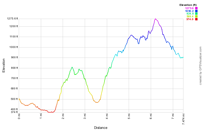 (The image at the left shows the profile of the hike. Remember that all vertical profiles are relative!)
New Jersey Border to Nyack
| Quick Look | |||
|---|---|---|---|
| Difficulty | Round trip | Total climb | Internet Maps |
| 10.5 mi. | 1720 ft. | AllTrails | |
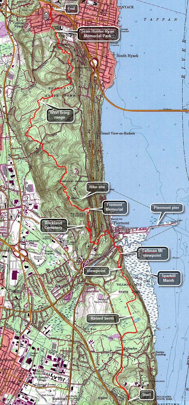
This hike is 10.5 miles ONE WAY. Unless you feel you can cover 21 miles, you will need to arrange a car spot or a ride.Take exit 11, Nyack, off the NYS Thruway. Turn left at the traffic light at the end of the exit onto Route 59. Park in a parking lot in one of the strip malls as close to where you turned as possible. Be sure to park away from any stores. Drive another car or get a ride to the Lamont-Doherty Observatory entrance which is south on Route 9W at the New York-New Jersey border to begin your hike. Walk passed then gatehouse down the sidewalk to find the aqua blazes of the Long Path. The first .7 miles of the trail heads downhill and parallels Route 9W passing through some hardwood forest and eventually meeting Route 9W. The traffic on 9W can be heavy at times but the road has wide shoulders. Head north on the road until 1.2 miles where the trail crosses the road to the parking area for Tallman State Park on the other side. The trail begins as a wide woods road and bike path with a firm surface which makes it easy to walk. Walk east and then turn north at 1.5 miles on what is more like a hiking trail. For the next .5 miles the trail follows along a raised walkway with lower wetlands on both sides. Some areas are just marshy while others have small ponds. At 2 miles turn east again and then start heading NNW along the edge of the escarpment. Look to the right to see the Hudson River and some views of the large Sparkill marsh below. Trees limit the photographic opportunities until the trail descends a hill to an area with benches at about 2.9 miles. From this area walk up a paved walkway and then turn onto a trail to get to the plateau that makes up what is called Tallman Mountain. Walk passed the shelter at the top on a paved roadway to a lookout just north of the shelter. Tallman Mountain has a maximum elevation of only 171 feet. From here you can still see the marsh below as well as views of the Tappan Zee Bridge and the village of Piermont below. The most interesting feature is a long spit of land that juts out into the river from Piermont. This is the mile long Piermont pier that was a terminus for the Erie Railroad. It also served as a point for ferry service to Dobbs Ferry on the other side of the river. Walk a little farther to find another lookout that has views down into Piermont. Back on the main trail walk down a steep hill to the road. Cross Sparkill Creek on a bridge and start walking north on Piermont Avenue passing some small shops. The trail is well-marked by aqua blazes and soon they will indicate a left turn onto a side street. Walk up Tate Street and near the top turn left up a set of stairs to Ash Street. At the corner across from you is the old Erie Railroad station for Piermont. The building is over 100 years old but has been resided. Follow the blazes on Ash Street west to Piermont Place. Head south on Piermont Place and then west on Crescent Road. Crescent Road is a dead end but the trail follows an old fire road at the end which heads south and then west to Route 9W. Turn right on Route 9W and then almost immediately left on Castle Road. Follow Castle Road for a short distance until the blazes indicated a right turn into the woods. Continue on the trail passing through some woods but still climbing. The trail eventually leads to the roads that run through the Rockland County Cemetery. Turned right almost 180 degrees and ascend to the top of the hill through a switchback. Follow the roads heading north along the escarpment and pass by many impressive grave markers. At 5 miles the Long Path passes the memorial for John C. Fremont. Fremont was a colorful figure who had a checkered career as an adventurer, politician, and military officer. Continue to follow the road until the blazes indicate a turn to the right. The trail heads west and then north continuing to climb and leaving the Rockland County Cemetery land to cross property marked as "Military Reservation". The Long Path skirts the summit of Mount Nebo and then reaches a high point at 585 feet on the shoulder of another unnamed hill. At about 5.75 mile an orange trail branches off to the right. The trail goes to Mount Nebo which was once the site of a Nike missile silo that protected New York City. It is now a recreation area. The trail starts to descend through hardwood forests as it enters Clausland Mountain County Park. At 7 miles cross Clausland Mountain Road and enter Tackamack Town Park which is maintained by the Town of Orangetown. Head northwest for about .25 miles to a small pond where the trail turns northeast and at 7.5 miles crosses Marisco Court to enter Blauvelt State Park. This is the first time on the hike that there is an evergreen forest as the trail begins to swing to the northeast. At about 8 miles you will cross over a low cement wall and turn to the right. Soon you will come to a higher cement wall. These are the remains of a World War I firing range and target walls. The tunnels connecting the two still remain here underground. Begin another ascent crossing a few streams along the way some with and some without bridges. At 8.8 miles cross North Tweed Boulevard and continue to climb to the highest point on the hike at about 625 feet. Some maps indicate a viewpoint here but there isn't too much to see. There is a large amount of broken glass on the rocks where inconsiderate people had found breaking bottles irresistible! Descend from this high point only to climb another and then another as you head generally north toward Nyack. Leave Blauvelt State Park and cross Bradley Hill Road at 9.8 miles. Make a quick ascent and then start the final descent into town. You are now in Sean Hunter Ryan Memorial Park. Sean Hunter Ryan was a Rockland County resident who died with his climbing partner, Philip Otis, on Mount Rainier in 1995. The two young men were park rangers involved in a rescue mission under extremely dangerous conditions. They remain the only two rangers to die on a rescue mission on Rainier. The trail comes to Towt Street where you should walk downhill to Waldron Avenue. Walk down the street and out to Route 59. Cross Route 59 and walk back to your car.
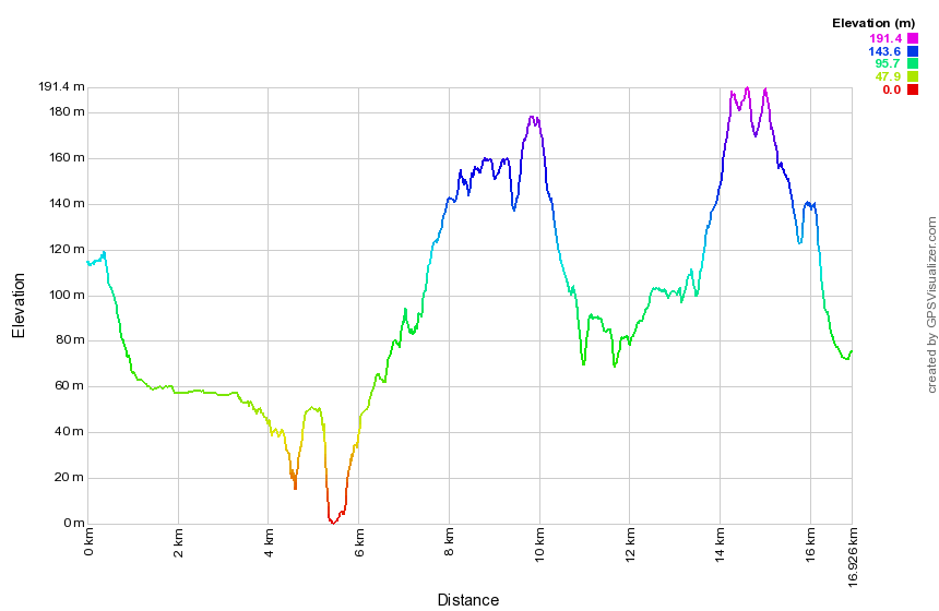 (The image at the left shows the profile of the hike. Remember that all vertical profiles are relative!)
Schunemunk Mountain: High Knob
| Quick Look | ||||
|---|---|---|---|---|
| Difficulty | Round trip | Total climb | Internet Maps | |
| 3.4 mi | 1240 ft | AllTrails | ||
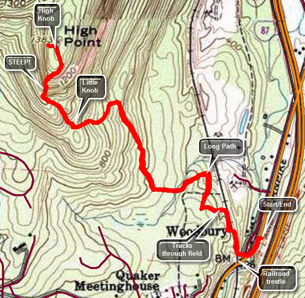 This hike is only 3.4 miles round trip but there are some VERY steep sections which can be difficult going both up and down.From the Woodbury Commons shopping mall, take Route 32 north through Woodbury and Highland Mills. Watch for a railroad trestle over the road. The trail start just north of the trestle. Just before the railroad trestle Evans Lane goes off to the left. You may be able to park on Evans Lane. The owner of the antique store just north of the trestle may let you park but be sure to ask him before you do. Start your hike by walking to the end of the private drive just north of the railroad trestle watching for the aqua blazes of the Long Path. Walk up the stone steps to the road that runs under the trestle. Cross the road and walk up the incline next to the trestle. There is a chain link fence along the right-of-way to discourage people from crossing over the tracks. The fence ends after a short distance by flaring up the bank from the tracks. DO NOT pass around the end of the fence to continue on the railroad right-of-way. Currently there may be no way to do this hike legally. The Long Path may have to be rerouted do to the new fencing. The trails in the fields to the left are on the property of Highland Stone whose office is just north on Route 32. Ask their permission before using the route described here. Turn left to walk out into the fields and find a path. Turn right and follow the trail which at first parallels the railroad tracks but then begins to head west. At about .4 miles turn right on the first trail that goes in that direction. In .1 miles you will be back on the Long Path and should make an immediate left to begin to climb. The surface of the trail is well-worn as this is a popular hike. It can be very dry with many loose stones. The trail is easy to follow and has a gentle slow at the beginning. At 1.25 miles you will be in the area of Little Knob and will have gained over 600 feet. Little Knob is to the right of the trail and there are informal paths that go to the top. You may visit Little Knob but the best views are on the trail up High Knob and from the top. Over the next .3 miles gain 420 feet until the trail finally levels as it approaches the highest spot on High Knob. This is an average of a 28% grade and some spots are even steeper! As you climb the view to the south and west comes into view. Immediately below is the village of Kiryas Joel with rows of neatly placed houses. Beyond are mountains and hills which are often shrouded in a haze. Be careful as you climb as some parts of the trail are rather exposed. Continue up until the trail levels and we were on top. The views from the top are especially nice looking north and east. To the north is the Newburgh-Beacon Bridge and North Beacon Mountain with its transmission towers. When you have taken in the views, you can continue to the Schunemunk Ridge where there are many possible loops. To return, turn around and work your way carefully back down the steep section to the easier trail below. Retrace your route back to the car.
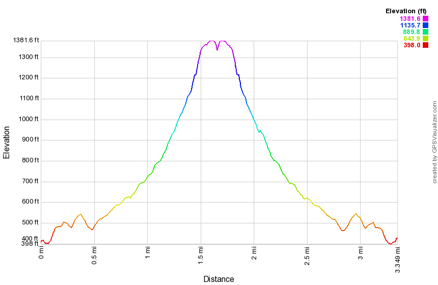 (The image at the left shows the profile of the hike. Remember that all vertical profiles are relative!)
Schunemunk Mountain: HilMar Counterclockwise
| Quick Look | ||||
|---|---|---|---|---|
| Difficulty | Round trip | Total climb | Internet Maps | |
| 6.8 mi | 1853 ft | AllTrails | ||
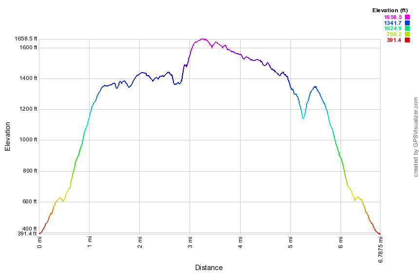
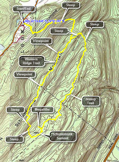 Take Route 94 to Salisbury Mills near Washingtonville. Turn east on Orrs Mills Road and after only .3 miles turn south on Clove Road. In about 1.3 miles watch for the HilMar Lodge on the left. The parking area is a few hundred feet beyond the entrance and is marked "Hiker Parking". From the parking area orange markers are visible as you look toward the woods. This trail is now called the Western Ridge Trail and is the one you should use to get to the western ridge of Schunemunk. The first part of the trail starts out with a very gentle slope and meanders through a hardwood forest at the base of the ridge. It starts heading southeast and then turns to the east. The trail becomes steeper as it climbs to the ridge but several switchbacks help. At about a mile the trail turns almost due south and ascends to the ridge where the Barton Swamp Trail ascends from the area between the two ridges. The walk to the ridge covers about 1.25 miles with an ascent of 970 feet. The walk along the western ridge is about 1.3 miles. Much of the time you will hike on slabs of conglomerate smoothed by glacial action. In other places the trail requires balancing on a ridge of the same rock. The trees are mostly dwarf pines shaped by their exposure to the winds on the ridge. Most of the time it is clear you are on a ridge as you can see both sides of it. To the east is a view of the eastern ridge and to the west lie the flatlands of Orange County. At 1.6 miles into the hike there is a viewpoint that gives a spectacular view to the west. The near view is of the flat land of Orange County which was once farms but is slowly changing to housing. In the distance to the west and north are the peaks of the Catskills. At the base of the ridge on the west is a large sand and gravel pit. As you continue to walk along the ridge another viewpoint appears at 2.2 miles. After this the trail descends along a rock face. Watch for the blue blazes of the trail that takes you down to the area between the ridges and then up to the eastern ridge. The descent is short but tricky and soon you will be on the red Barton Swamp Trail that runs the length of the area between the two ridges. Turn right and walk a short distance until the two trails split and follow the blue trail up to the eastern ridge. This ascent is considerably longer than the descent since the eastern ridge is higher. There are many places where you will have to scramble up the rocks. In .3 miles you gain 275 feet to where the trail moderates some on the ridge. At the top of the ridge you will find the Jessup Trail which is marked with its own yellow blazes. It also has the aqua blazes of the Long Path and signs designating it as part of the Highlands Trail. Turn left and within a few hundred feet you will be standing on the highest point on either ridge at 1664 feet. This is also the highest point in Orange County. Continue on the main trail for about 500 feet more and watch for the spur trail to the left that leads to the Megaliths. These are huge masses of rock that have split from the main rock of the ridge. The walk out to the megaliths is short and well worth the visit. Back on the main trail head north on the eastern ridge. The rest of the hike will be downhill except for the climb from the area between the ridges back up to the western ridge. At 3.8 miles you will pass the junction with the Dark Hollow Trail and at 4.6 miles you will find the junction with the Sweet Clover Trail. Stay on the Jessup Trail as it works its way north and starts to descend the north end of the ridge. From several viewpoints you can see the Hudson River and the Newburgh Beacon Bridge. At 5.3 miles you will have descended to the area between the ridges where the Jessup Trail continues off to the right. Follow the red Barton Swamp Trail as it climbs 200 feet in .25 miles to the eastern ridge. Within a few hundred feet from the top you will be back at the junction with the Western Ridge Trail that takes you back to your car.
 (The image at the left shows the profile of the hike. Remember that all vertical profiles are relative!)
Schunemunk Mountain: Otterkill to Dark Hollow
| Quick Look | ||||
|---|---|---|---|---|
| Difficulty | Round trip | Total climb | Internet Maps | |
| 8.2 mi | 2053 ft | AllTRails | ||
 Park at trail head parking area on Otterkill Road just outside of Salisbury Mills in Orange County.
The parking area is easily in sight of the Metro North train trestle. Walk on the road toward the
trestle. In less than .25 miles and just before the trestle, cross the road an enter the woods.
The trail immediately begins to climb up a hill on a wide trail or woods road. At the first
junction keep to the left to get on the red Otterkill Trail. After about 1.5 miles of fairly easy walking,
you will arrive at the junction with the yellow-blazed Jessup Trail and the aqua-blazed Highland Trail.
At this point a bridge crosses Baby Brook. The brook runs under the tracks through a short but interesting
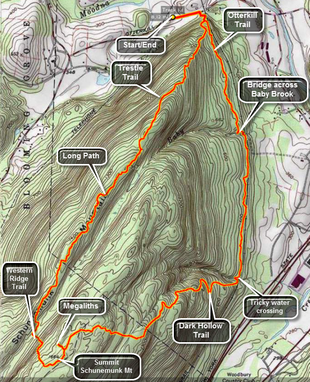
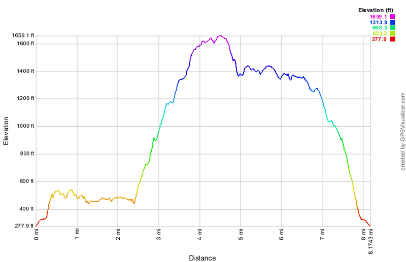
tunnel. There is also a small waterfall at this location. The Otterkill Trail parallels the railroad tracks for 2.1 miles. Although the total ascent amounts to 300 feet the change in elevation from one end to the other is 10 feet! It is flat but rolls a little. This does not mean that it is boring. As you start out on the trail and ascend a little rise there is a lookout to the east. This viewpoint is not very high but offers a nice view of the hills to the east. There is an extensive network of stone walls in this area. Some of these wall are low but many are built up. These remnants of a past way of life are interesting. The solid construction of these walls makes them permanent and a real indication that someone worked hard and sweated hard to farm the land. At 1.2 miles the trail turns sharply to the left on one of the many woods roads in the park. Baby Brook is straight ahead with a bridge to get you to the other side. There is a tunnel here to carry the railroad over the brook. There is also a small falls below the bridge. Continue along the trail until at 2.4 miles there is another nice falls and a crossing of Dark Hollow Brook that has no bridge. This crossing is easy when the weather has been dry but more difficult under wet conditions. Almost immediately after the crossing the Otterkill Trail ends and the dark Hollow Trail starts up the mountain to the right. The Dark Hollow Trail follows an old woods road generally southeast and up the ridge. The road is eroded and very rocky in places It makes several switchbacks in places as the grade would have been too steep for horse drawn wagons otherwise. At about 2.9 miles there is a nice lookout after a short climb. The views to the east and north are very nice. Continue to hike after I took some pictures. In some spots the trail leaves the road and makes a short climb up to the next level to rejoin the same road. This cuts a little distance and avoids the long switchbacks. These "shortcuts" also make the hike more interesting. As the trail climbs two things happen. First, there were at least four places where you seem to be on the top of the ridge. Second, the maps show two crossings of Dark Hollow Brook but there are at least four. At 3.6 miles there is another viewpoint on top of a massive rock outcrop. Climb again and the trail flattens at about 3.8 miles in an open area with incredible views in all directions except to the west. This might be the best viewpoint in the whole park. Continue on the trail and at about 4 miles you will be at the end of The Dark Hollow Trail at Dark Hollow Junction. Turn left onto Jessup Trail which is also the Highlands trail to head toward the Megaliths. The Jessup Trail winds its way along the eastern ridge over many open rock faces with scrub pines. This is an entirely different ecology than at the lower elevations. At times the trail climbs over rock outcrops and at others dives into the pines. At 4.3 miles the spur trail to the Megaliths turns right. Approach quietly since the local vultures often hang out on the rocks surveying the countryside below. Back on the main Jessup Trail turn right and at 4.6 miles turn right onto the blue Western Ridge Trail. This trail is routed over some open rocks faces before it starts to descends the ridge. Just at the point it starts the descent is another nice viewpoint. On the descent the trail becomes very narrow and hen the rocks are damp this can be quite a challenge. Continue down the Western Ridge Trail until it bottoms out a Barton Swamp. There is some old corduroy here to help you across. Once on the other side of the swamp turn right on the red Barton Swamp Trail and then turn left almost immediately to head up to the western ridge. The trail here runs right along an open rock face pitched at about 40 degrees. It soon turns up to the safety of the ridge but the first part is interesting. Once on the ridge there are places where the trail is sited directly on top of a knife edge of rock. There are a few ups and down to keep things interesting. There are also several informal paths which can mislead hikers who do not pay attention. The further you walk along the ridge the better the views become. There is a nice lookout at 5.6 miles and then the Sweet Clover`Trail comes over from the eastern ridge at 6 miles. Just passed this junction another lookout gives a nice view of the valley. Prominent in the view are a sand and gravel pit to the southwest and a lake with homes to the north. Head to the next trail junction and turn to the right to follow the Jessup Trail briefly. When the Jessup Trail meets the Trestle Trail continue straight ahead on the Trestle Trail. This trail is always rocky with small pebbles which like to roll making the footing tricky. At 7.45 miles walk out to a memorial bench which has a great view. Head down the trail to the road and your car.
Park at trail head parking area on Otterkill Road just outside of Salisbury Mills in Orange County.
The parking area is easily in sight of the Metro North train trestle. Walk on the road toward the
trestle. In less than .25 miles and just before the trestle, cross the road an enter the woods.
The trail immediately begins to climb up a hill on a wide trail or woods road. At the first
junction keep to the left to get on the red Otterkill Trail. After about 1.5 miles of fairly easy walking,
you will arrive at the junction with the yellow-blazed Jessup Trail and the aqua-blazed Highland Trail.
At this point a bridge crosses Baby Brook. The brook runs under the tracks through a short but interesting
tunnel. There is also a small waterfall at this location. The Otterkill Trail parallels the railroad tracks for 2.1 miles. Although the total ascent amounts to 300 feet the change in elevation from one end to the other is 10 feet! It is flat but rolls a little. This does not mean that it is boring. As you start out on the trail and ascend a little rise there is a lookout to the east. This viewpoint is not very high but offers a nice view of the hills to the east. There is an extensive network of stone walls in this area. Some of these wall are low but many are built up. These remnants of a past way of life are interesting. The solid construction of these walls makes them permanent and a real indication that someone worked hard and sweated hard to farm the land. At 1.2 miles the trail turns sharply to the left on one of the many woods roads in the park. Baby Brook is straight ahead with a bridge to get you to the other side. There is a tunnel here to carry the railroad over the brook. There is also a small falls below the bridge. Continue along the trail until at 2.4 miles there is another nice falls and a crossing of Dark Hollow Brook that has no bridge. This crossing is easy when the weather has been dry but more difficult under wet conditions. Almost immediately after the crossing the Otterkill Trail ends and the dark Hollow Trail starts up the mountain to the right. The Dark Hollow Trail follows an old woods road generally southeast and up the ridge. The road is eroded and very rocky in places It makes several switchbacks in places as the grade would have been too steep for horse drawn wagons otherwise. At about 2.9 miles there is a nice lookout after a short climb. The views to the east and north are very nice. Continue to hike after I took some pictures. In some spots the trail leaves the road and makes a short climb up to the next level to rejoin the same road. This cuts a little distance and avoids the long switchbacks. These "shortcuts" also make the hike more interesting. As the trail climbs two things happen. First, there were at least four places where you seem to be on the top of the ridge. Second, the maps show two crossings of Dark Hollow Brook but there are at least four. At 3.6 miles there is another viewpoint on top of a massive rock outcrop. Climb again and the trail flattens at about 3.8 miles in an open area with incredible views in all directions except to the west. This might be the best viewpoint in the whole park. Continue on the trail and at about 4 miles you will be at the end of The Dark Hollow Trail at Dark Hollow Junction. Turn left onto Jessup Trail which is also the Highlands trail to head toward the Megaliths. The Jessup Trail winds its way along the eastern ridge over many open rock faces with scrub pines. This is an entirely different ecology than at the lower elevations. At times the trail climbs over rock outcrops and at others dives into the pines. At 4.3 miles the spur trail to the Megaliths turns right. Approach quietly since the local vultures often hang out on the rocks surveying the countryside below. Back on the main Jessup Trail turn right and at 4.6 miles turn right onto the blue Western Ridge Trail. This trail is routed over some open rocks faces before it starts to descends the ridge. Just at the point it starts the descent is another nice viewpoint. On the descent the trail becomes very narrow and hen the rocks are damp this can be quite a challenge. Continue down the Western Ridge Trail until it bottoms out a Barton Swamp. There is some old corduroy here to help you across. Once on the other side of the swamp turn right on the red Barton Swamp Trail and then turn left almost immediately to head up to the western ridge. The trail here runs right along an open rock face pitched at about 40 degrees. It soon turns up to the safety of the ridge but the first part is interesting. Once on the ridge there are places where the trail is sited directly on top of a knife edge of rock. There are a few ups and down to keep things interesting. There are also several informal paths which can mislead hikers who do not pay attention. The further you walk along the ridge the better the views become. There is a nice lookout at 5.6 miles and then the Sweet Clover`Trail comes over from the eastern ridge at 6 miles. Just passed this junction another lookout gives a nice view of the valley. Prominent in the view are a sand and gravel pit to the southwest and a lake with homes to the north. Head to the next trail junction and turn to the right to follow the Jessup Trail briefly. When the Jessup Trail meets the Trestle Trail continue straight ahead on the Trestle Trail. This trail is always rocky with small pebbles which like to roll making the footing tricky. At 7.45 miles walk out to a memorial bench which has a great view. Head down the trail to the road and your car.
 (The image at the left shows the profile of the hike. Remember that all vertical profiles are relative!)
Schunemunk Mountain: Trestle to Jessup Trails (Clockwise)
| Quick Look | ||||
|---|---|---|---|---|
| Difficulty | Round trip | Total climb | Internet Maps | |
| 6.7 mi | 1838 ft | AllTrails | ||
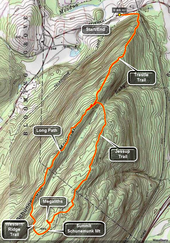 Park at trail head parking area on Otterkill Road just outside of Salisbury Mills in Orange County.
The parking area is easily in sight of the Metro North train Trestle. Walk on the road toward the
trestle. In less than .25 miles and just before the trestle, cross the road an enter the woods.
The trail immediately begins to climb up a hill on a wide trail or woods road. At the first
junction keep to the right to stay on the Trestle Trail which is marked with white blazes. After
about 1.2 miles of steady climbing, you will arrive at the junction with the red-blazed Jessup Trail.
You are on the western ridge. Turn left and be prepared to descend quickly across and over bare
rock faces. CAUTION: These rocks can be very slippery when wet or when covered
with snow or ice! After about .15 miles of descent cross Baby Brook and ascend to the
eastern ridge. The crossing of Baby Brook can be tricky for some at high water but usually poses
no real impediment. The ascent is steep and again is over much exposed rock.
Park at trail head parking area on Otterkill Road just outside of Salisbury Mills in Orange County.
The parking area is easily in sight of the Metro North train Trestle. Walk on the road toward the
trestle. In less than .25 miles and just before the trestle, cross the road an enter the woods.
The trail immediately begins to climb up a hill on a wide trail or woods road. At the first
junction keep to the right to stay on the Trestle Trail which is marked with white blazes. After
about 1.2 miles of steady climbing, you will arrive at the junction with the red-blazed Jessup Trail.
You are on the western ridge. Turn left and be prepared to descend quickly across and over bare
rock faces. CAUTION: These rocks can be very slippery when wet or when covered
with snow or ice! After about .15 miles of descent cross Baby Brook and ascend to the
eastern ridge. The crossing of Baby Brook can be tricky for some at high water but usually poses
no real impediment. The ascent is steep and again is over much exposed rock.
The Jessup Trail runs across the eastern ridge and alternates between areas of rock and forest. Most of the rocky areas are tilted and offer little or no vegetation to assist in your traverse. Some parts of the trail are routed up and over substantial boulders or outcroppings. Other parts take you along thin spines of conglomerate. If you have the time, look carefully at the rock. At first it looks similar to that in the Shawangunks. On closer inspection the conglomerate has a pink tingle from hematite deposits. It also has more defined and larger white quartz crystals and is "rougher" in appearance. Be careful as you are hiking to put your safety before your geological studies. The trail continues to ascend for about 1.5 miles. At this point it flattens somewhat and a spur trail with white markings goes off to the left. This trail leads to the Megaliths. These are larger blocks of rock which have broken off from the bedrock and have fallen in place. They are worth the trip since the whole walk is less than a quarter mile!
Back on the main trail there is slight ascent to the highest point on Schunemunk Mountain at 1664 feet. It seems much higher and like you have done more climbing. This may be because the trail head elevation is only 250 feet. within .35 miles the Western Ridge Trail turns right. Follow these blue marks down into Barton Swamp to the red blazed Barton Swamp Trail. Part of this area is on private land so stay on the trail as you negotiate your way through this swamp. Stay on the red and blue blazes for less than a quarter mile where the Western Ridge trail ascends directly up to the top of the western ridge. This ascent is short but very steep and the rocks seem smoother and slippery than on the eastern side.
At the top of the ridge turn right and look for the aqua blazes of the Long Path. Stay on the
Long Path for about 1.25 miles. The Long Path is much like the Jessup Trail on the eastern ridge.
It passes over areas of bare rock and through areas of forest. On this ridge there seems to be
more forest and less rock which makes the hiking easier. The elevation change is also not as
pronounced as on the eastern ridge. After 1.25 miles look for the red blazes of the Jessup Trail
on the right. Turn onto the trail and follow it for about .2 miles. At this point you will see the
white blazes of the Trestle Trail on the left and you will be at the junction where you turned
at the beginning of the hike. Turn left on the Trestle Trail and descend back to the road and to
your car at the parking area. Be careful on the descent since the trail is steeper than you might
think. Descending the trail gives you a good idea of why ascending required so much effort at the
beginning of the hike!
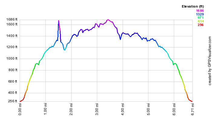 (The image at the left shows the profile of the hike. Remember that all vertical profiles are
relative!)
(The image at the left shows the profile of the hike. Remember that all vertical profiles are
relative!)
Schunemunk Mountain: Trestle to Long Path (Anticlockwise)
| Quick Look | ||||
|---|---|---|---|---|
| Difficulty | Round trip | Total climb | Internet Maps | |
| 6.5 mi | 1797 ft | AllTrails | ||
Park at trail head parking area on Otterkill Road just outside of Salisbury Mills in Orange County.
The parking area is easily in sight of the Metro North train Trestle. Walk on the road toward the
trestle. In less than .25 miles and just before the trestle, cross the road an enter the woods.
The trail immediately begins to climb up a hill on a wide trail or woods road. At the first
junction keep to the right to stay on the Trestle Trail which is marked with white blazes. After
about 1.2 miles of steady climbing, you will arrive at the junction with the red-blazed Jessup Trail.
You are on the western ridge. Turn right walk a VERY short distance to another trail junction with the Long Path where the Jessup Trail ends. Turn left to stay on the Long Path and walk the western ridge. Over the next 1.3 miles the Long Path stays on the western ridge and your walk is almost flat with a few ups and downs across the open conglomerate rock face. At 2.7 miles the blue Western Ridge Trail comes up to the ridge from Barton Swamp below. Turn left here and follow the blazes down into the swampy area and up to the eastern ridge. Near the top of the ascent the Western Ridge Trail ends at the red Jessup Trail on the eastern Ridge. Turn left and in a few hundred feet you will be at the summit of Schunemunk Mountain. A USGS seal embedded in the rock and an inscription noting the site of a fire tower mark this point. In .25 miles a short side trail to the left leads to the Megaliths. These are larger blocks of rock which have broken off from the bedrock and have fallen in place. Back on the main trail you will walk a gentle descent for about 1.6 miles until at 5 miles you reach a crossing of Baby Brook. The trail is steeper but shorter up the other side to the junction with the Trestle Trail. Turn right on the white Trestle Trail and walk the 1.4 miles back to the car.
They are worth the trip since the whole walk is less than a quarter mile!
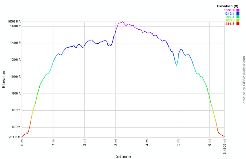
(The image at the left shows the profile of the hike. Remember that all vertical profiles are relative!)
Schunemunk Mountain: Trestle to Otterkill to Jessup Trails
| Quick Look | ||||
|---|---|---|---|---|
| Difficulty | Round trip | Total climb | Internet Maps | |
| 8.0 mi | 1818 ft | AllTrails | ||
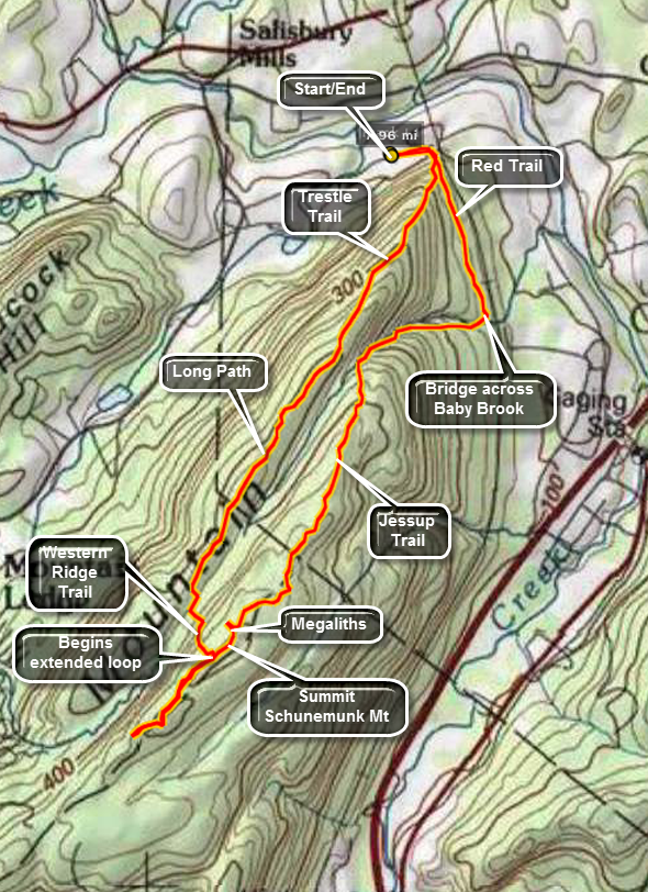 Park at trail head parking area on Otterkill Road just outside of Salisbury Mills in Orange County.
The parking area is easily in sight of the Metro North train Trestle. Walk on the road toward the
trestle. In less than .25 miles and just before the trestle, cross the road an enter the woods.
The trail immediately begins to climb up a hill on a wide trail or woods road. At the first
junction keep to the left to get on the Red Trail. After about 1.5 miles of fairly easy walking,
you will arrive at the junction with the yellow-blazed Jessup Trail and the aqua-blazed Highland Trail.
At this point a bridge crosses Baby Brook. The brook runs under the tracks through a short but interesting
tunnel. There is also a small waterfall at this location. Turn right to pick up the Jessup-Highland Trail.
These trails parallel Baby Brook for some distance. There are several small rapids or waterfalls along the way
but most are hidden by thick brush. At one spot the trail passes closer to the brook and there is another small
cascade at this location. As you climb to the eastern ridge you can see the ridge looming over you. At the next
junction turn left and follow the Jessup-Highland trail. The ascent is steep and again is over much exposed rock.
Park at trail head parking area on Otterkill Road just outside of Salisbury Mills in Orange County.
The parking area is easily in sight of the Metro North train Trestle. Walk on the road toward the
trestle. In less than .25 miles and just before the trestle, cross the road an enter the woods.
The trail immediately begins to climb up a hill on a wide trail or woods road. At the first
junction keep to the left to get on the Red Trail. After about 1.5 miles of fairly easy walking,
you will arrive at the junction with the yellow-blazed Jessup Trail and the aqua-blazed Highland Trail.
At this point a bridge crosses Baby Brook. The brook runs under the tracks through a short but interesting
tunnel. There is also a small waterfall at this location. Turn right to pick up the Jessup-Highland Trail.
These trails parallel Baby Brook for some distance. There are several small rapids or waterfalls along the way
but most are hidden by thick brush. At one spot the trail passes closer to the brook and there is another small
cascade at this location. As you climb to the eastern ridge you can see the ridge looming over you. At the next
junction turn left and follow the Jessup-Highland trail. The ascent is steep and again is over much exposed rock.
The Jessup Trail runs across the eastern ridge and alternates between areas of rock and forest. Most of the rocky areas are tilted and offer little or no vegetation to assist in your traverse. Some parts of the trail are routed up and over substantial boulders or outcroppings. Other parts take you along thin spines of conglomerate. If you have the time, look carefully at the rock. At first it looks similar to that in the Shawangunks. On closer inspection the conglomerate has a pink tingle from hematite deposits. It also has more defined and larger white quartz crystals and is "rougher" in appearance. Be careful as you are hiking to put your safety before your geological studies. The trail continues to ascend for about 1.5 miles. At this point it flattens somewhat and a spur trail with white markings goes off to the left. This trail leads to the Megaliths. These are larger blocks of rock which have broken off from the bedrock and have fallen in place. They are worth the trip since the whole walk is less than a quarter mile!
Back on the main trail there is slight ascent to the highest point on Schunemunk Mountain at 1664 feet. It seems much higher and like you have done more climbing. This may be because the trailhead elevation is only 250 feet. Within .35 miles the Western Ridge Trail turns right. Continue straight ahead for .75 miles to the junction with the Long Path. Turn around and walk back to the junction with the orange blazed Western Ridge Trail. Follow th orange marks down into Barton Swamp and along Barton Swamp Trail. Part of this area is on private land so stay on the trail as you negotiate your way through this swamp. Stay on the this trail for less than a quarter mile where the orange Western Ridge trail ascends directly up to the top of the western ridge. This ascent is short but very steep and the rocks seem smoother and slipperier than on the eastern side.
At the top of the ridge turn right and follow the orange blazes of the Western Ridge Trail. Stay on this
trail for about 1.25 miles. The Western Ridge is much like the Jessup Trail on the eastern ridge. It passes over areas of bare rock and through areas of forest. On this ridge there seems to be
more forest and less rock which makes the hiking easier. The elevation change is also not as pronounced as on the eastern ridge. After 1.25 miles look for the red blazes of the Jessup Trail
on the right. Turn onto the trail and follow it for about .2 miles. At this point you will see the
white blazes of the Trestle Trail on the left and you will be at the junction where you turned
at the beginning of the hike. Turn left on the Trestle Trail and descend back to the road and to
your car at the parking area. Be careful on the descent since the trail is steeper than you might
think. Descending the trail gives you a good idea of why ascending required so much effort at the
beginning of the hike!
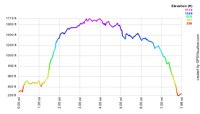
(The image at the left shows the profile of the hike. Remember that all vertical profiles are relative!)
Schunemunk Mountain: Trestle to Western Ridge (Out and Back)
| Quick Look | ||||
|---|---|---|---|---|
| Difficulty | Round trip | Total climb | Internet Maps | |
| 5.5 mi | 1412 ft | AllTrails | ||
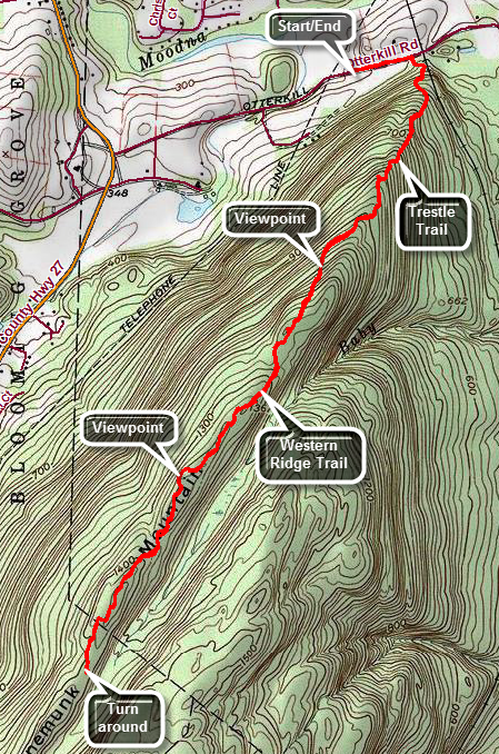 Park at trail head parking area on Otterkill Road just outside of Salisbury Mills in Orange County. The parking area is easily in sight of the Metro North train Trestle. Walk on the road toward the trestle. In less than .25 miles and just before the trestle, cross the road an enter the woods. The trail immediately begins to climb up a hill on a wide trail or woods road. At the first junction keep to the right to stay on the Trestle Trail which is marked with white blazes. Near the top of the climb watch for spur trail on the right that leads to a bench and a nice viewpoint. After about 1.2 miles of steady climbing, you will arrive at the junction with the red-blazed Jessup Trail. You are on the western ridge. Turn right walk a VERY short distance to another trail junction with the orange-blazed Western Ridge Trail where the Jessup Trail ends. Turn left to stay on the Western Ridge Trail and walk the western ridge. Over the next 1.3 miles the Western Ridge Trail stays on the western ridge and your walk is almost flat with a few ups and downs across the open conglomerate rock face. Watch for a nice lookout with open views to the north and west. The Catskills are visible in the distance. Below the lookout there is a sand and gravel operation next to beautiful Lenni Lenape Lake. At 2.7 miles Western Ridge Trail descends to Barton Swamp below. Turn around here and retrace your steps back to the parking area.
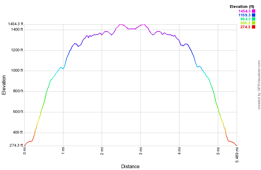
(The image at the left shows the profile of the hike. Remember that all vertical profiles are relative!)
Shaupeneak Ridge: Blue, Yellow, Orange, Aqua Trails
| Quick Look | ||||
|---|---|---|---|---|
| Difficulty | Round trip | Total climb | Internet Maps | PDF Maps |
| 5.8 mi. | 825 ft. | AllTrails | PDF Maps | |
To get to the Poletown Road trailhead for Shaupeneak Ridge, drive north or south on Route 9W to the hamlet of Esopus. Old Post Road travels west from Route 9W and is just across from Parker Avenue. After making the turn, cross the railroad tracks and drive 1.7 miles on Old Post Road to where the road makes a sharp left turn. Continue straight ahead on Popletown Road and drive .8 miles to the trailhead on the left. Leave the parking area on the blue trail heading southwest to start a clockwise loop around the pond. The trail starts off as a gravel path which is very even and well groomed. Almost immediately there is an area with two benches and a nice view over Louisa Pond. Continue along the blue trail to the kayak launch within a few hundred feet. We walk down to the shore for another view of the pond. Get back on the blue trail and walk over a wooden walkway after which the trail becomes more like a trail rather than a path. Walk through a rocky area and then enter a pine forest at the outlet end of the lake to the southwest. The trail here can be slippery when it is wet or damp. At about .4 miles you will arrive at the beaver dam that impounds the water for the pond. There is another nice view over the entire pond. Continue on around the pond by walking up a hill and heading northeast. The blazes for the orange trail will appear on the left but this trail will be saved for later in the hike. Continue along the blue trail and passed the second junction with the orange trail and the beginning of the green trail. Continue on the blue trail back to the parking area at 1.35 miles. Find the yellow trail that heads up the bank from the parking area. This trail parallels the blue trail around the pond but is a little further away and travels along a series of rock ledges. At the start of the trail there is a sign that explains the significance of stone walls. This trail has a series of these signs with some being more informative and understandable than others. The trail is short and soon descends to meet the blue trail. Turn left and start clockwise around the lake again. At 1.85 miles turn left onto the orange trail which heads south and then turns west. At 2.15 miles there is a deep gorge and the trail swings north to loop around the top of this area. Follow the trail continuing to gain elevation as it eventually heads west and then south again along the ravine. Eventually you will be at a point directly across from where you started the loop. The detour is a little over .3 miles to get to a point 170 feet away from where you started! The trail goes west a short distance and then heads north. Watch for the crossover trail that connects the orange to the green trail and is marked with orange and green blazes. At 2.75 miles the crossover trail turns off to the left and heads north to the green trail. It drops elevation for its entire .2 mile length. When you hit the green trail, turn left and follow the green trail to 3.1 miles where the aqua trail begins on the left.Turn left and followed the trail until it splits within a few hundred feet. Head left first heading south.Pass through an open forest where the forest floor is covered in ferns. Continue south to about 3.6 miles where the trail makes an almost 180 degree turn north. At 3.85 miles the trail makes a large loop to the west before heading northeast. The aqua trail is another trail that, like the green trail, was created for both mountain biking and hiking. There are some impressive rock ledges along the way which makes the walk interesting despite the lack of expansive views. At 4.4 miles you will be back at the point where the aqua trail splits. Walk out to the green trail and turn right to retrace your steps back to the crossover trail. Turn right and climb out of the hollow to the ridge. Once back at the junction with the orange trail, turn left to complete the loop of this trail. This trail also has no views but is an interesting walk along a high set of rock ledges. Soon you will be at the junction with the blue trail. Turn left to go around the northern end of the wetland since this is a better part of the blue trail. The last .4 miles of the hike went quickly is a part of the trail you walked earlier and should go quickly.
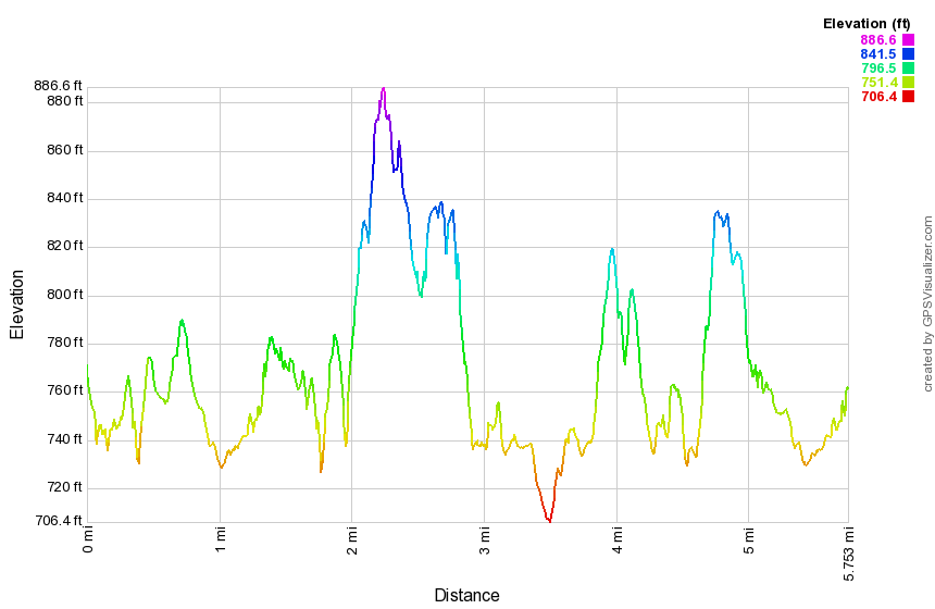
(The image at the left shows the profile of the hike. Remember that all vertical profiles are relative!)
Shaupeneak Ridge: White, Red, Green Trails
| Quick Look | ||||
|---|---|---|---|---|
| Difficulty | Round trip | Total climb | Internet Maps | PDF Maps |
| 6.8 mi. | 1345 ft. | AllTrails | PDF Maps | |
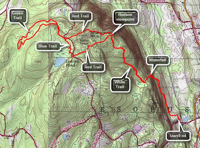
To get to the Old Post Road trailhead for Shaupeneak Ridge, drive north or south on Route 9W to the hamlet of Esopus. Old Post Road travels west from Route 9W and is just across from Parker Avenue. After making the turn, cross the railroad tracks and look for a sign for the parking area on the right. Leave the parking area on the white trail passing the kiosk which has trail maps for the entire ridge. The trail is well packed and travels first through an open area and then enters the woods. Immediately start to gain elevation although the trail is not steep. At .65 miles a purple trail branches off to the right. Follow it several hundred feet where it ends at a waterfall. The waterfall may be almost absent in dry weather and all you may see is the rocky stream bed. Return to the white trail, turn right and continued to climb. Much of the hike seems to be of the "roots, rocks, trees" variety although it is very pretty. Over the final mile of the white trail, you will climbed 560 feet for an average of about a 10% grade. At the top of the white trail turn right on the red trail and immediately come to a lookout to the Hudson River. Leave the viewpoint to continue on the red trail hiking west and descending some. At 2.4 miles the red trail ends at the blue trail. Turn right and follow the blue trail as it heads northwest around the north end of the pond. At 2.5 miles the green trail begins turning right and is a loop constructed by mountain bikers. The trail includes some rock ledges. Begin a short descent along a woods road. On the right there is an extensive network of stone walls and, at one point, a road built up of rock near a small pond. Continue along the green trail until it forks and turn right at 2.6 miles to take the more northern route. The trail begins to ascend slightly and heads southwest. Along the way you will pass through an area that has some very tall trees and where the ground is covered with a dense layer of ferns. Continue on the trail passing some nice rock ledges and some stone paved steps. There are also some logs that had been flattened on top for the more skilled bike riders. Watch for a garden gnome on the left side of the rail in a small "cave" under a boulder! At 3.4 miles the green trail makes an almost 180 degree turn to head back toward its origin and the aqua trail branches to the right. Follow the green trail to complete the entire green loop! Continue on the green trail back to the blue trail and turn left to follow the trail down the east shore of Louisa Pond. When you arrive at the parking area for Shaupeneak Ridge on Popletown Road, turn left and walk out to the entrance of the lot. Cross the road to pick up the more southern branch of the red trail at 4.65 miles. Walk .55 miles over this part of the red trail which rolls a little but gains some elevation. At 5.2 miles turn right on the white trail to follow it southeast back to the cars. The trail is a descent all the way except for one small climb.
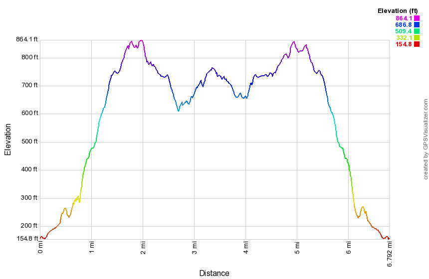
(The image at the left shows the profile of the hike. Remember that all vertical profiles are relative!)
Sterling Forest: Bare Rock Loop
| Quick Look | ||||
|---|---|---|---|---|
| Difficulty | Round trip | Total climb | Internet Maps | |
| 10.7 mi. | 2145 ft. | AllTRails | ||
Take Route 17A from Warwick, NY south and east toward Greenwood Lake. In Greenwood Lake bear left as Route 17A climbs the ridge. Park in the large parking area near the top of the ridge where the Allis Trail crosses the road.
Park at the lot for the Sterling Ridge and Sterling Valley Trails. Take the yellow Sterling Valley Loop Trail out of the parking area just passed a gate> In a short distance turn right and up to the ridge on the blue Sterling Ridge Trail. This trail climbs for about .25 miles and then travels along the ridge with a few ups and downs. At about 2 miles there is a nice viewpoint overlooking Sterling Lake. At about 2.3 miles the orange blazed Bare Rock Trail branches off to the right. The Bare Rock Trail stays rather level for a short distance and then begins to descend somewhat. After descending the trail rises toward a ridge; that parallels Greenwood Lake. The trail stays off the ridge and you will wonder if it ever gets to the lookout. At 3.7 miles a clearly marked side trail drops to the viewpoint on the east side of Greenwood Lake. The viewpoint is VERY nice allowing views of the lake and the Bellvale-Bearfort Ridge. Back up on the main trail turn right to continue the loop hike. For the next 1.6 miles the trail climbs over a hill and then begins a descent to the junction with the green blazed West Valley Trail and the red blazed Fire Tower Trail. The trails here are poorly marked and may cause some confusion. In addition, a beaver dam has flooded the area immediately ahead on the green trail. The best option is to find a way across Jennings Creek and then walk through the woods (bushwhack) to the top of the ridge where you can pick up the Sterling Ridge Trail. You may find a woods road or a white blazed trail up to the ridge but these are not on most maps. Once on the Sterling Ridge and Highlands Trail you will ascend an interesting part of the trail to a lookout and then descend before tackling the steep trail up to the tower. The part of the trail up to the tower is only .4 miles but gains almost 300 feet. Whether the tower is open or closed seems to be a hit-or-miss situation! There are good views of both Greenwood Lake and Sterling Lake. Descend the red Fire Tower Trail until you hit the red Fire Tower Connector trail at 7.75 miles and turn north. In a short distance you will find the Sterling Lake Loop Trail headed north along the lake shore. Walk 1.2 miles along the shore to the junction with the yellow Sterling Valley Loop Trail. Before going to the left on this trail and back up to the car bear to the right and go down to a nice viewpoint on the lake. There is a small point of land that sticks out into the lake. Walk back to the trail junction and turn right. The last 1.6 miles starts out flat along a wide road and then begins to ascend near the end to regain the elevation of the parking lot.
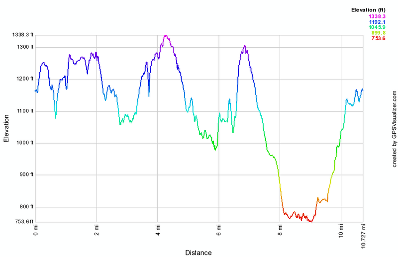
(The image at the left shows the profile of the hike. Remember that all vertical profiles are relative!)
Sterling Forest: Complete Loop
| Quick Look | ||||
|---|---|---|---|---|
| Difficulty | Round trip | Total climb | Internet Maps | |
| 9.2 mi. | 1467 ft. | AllTrails | ||
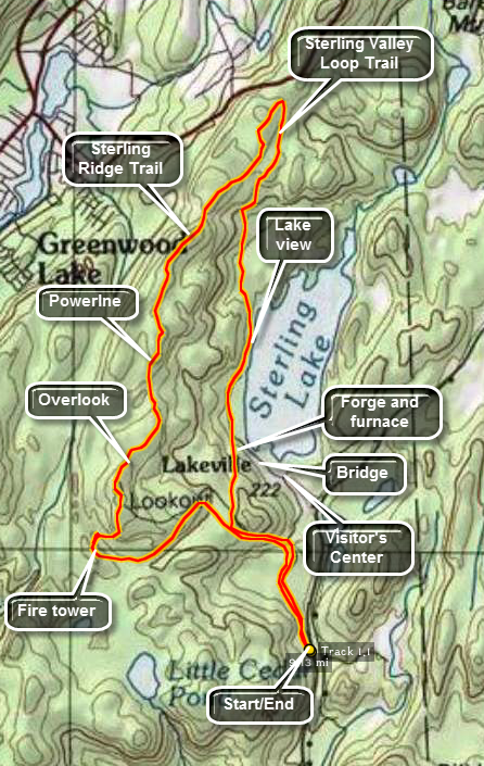
From Route 17A near Indian Reservoir, take Long Meadow Road south. Pass the entrance to the Sterling Forest Visitor's Center on Old Forge Road and continue south for another 1.5 miles. A road that leads to the seasonal parking area will be on the right. You may have to park outside the gate if the road is closed for the winter. Walk to the far end of the parking area and continue on Lakeville Road. Watch for the three red blazes on your left that signal the beginning of the Fire Tower Trail. This trail climbs rather gently through open forest to Sterling Ridge. After about 1.4 miles you will be at the fire tower. This tower is believed to be the only active fire tower left in New York State. A ranger is assigned to the tower to watch for fires in southern New York and northern New Jersey. The ranger is NOT always on duty so call ahead to the Visitor's Center to find out if the tower will be open. When a ranger is not on duty, a locked gate blocks access to the tower. The views from Sterling Ridge are limited in most areas but the views from the tower are great in all directions.
Once you are satisfied that you have seen all you can from the tower, find the blue blazes of the Sterling Ridge Trail as they head north toward Route 17A. Most of the views from the ridge are blocked by trees but just after the tower there are some nice views down to Sterling lake. This is a nice place to stop and take some pictures and to have lunch or a snack. After this the trail wanders up and town, crosses a power line right-of-way and then meets the orange Bare Rock Trail after 1.25 miles. This trail comes up from Sterling Lake near the Visitor's Center and is a good "bail out" I time becomes limited. Continue for 1.85 miles on the Sterling Ridge Trail to the parking area near Route 17A. This route goes some distance passed the head of Sterling lake before turning back toward the lake.
Turn right on yellow Sterling Valley Loop Trail which heads back toward the lake. Continue 1.3 miles to Sterling Lake and the blue Sterling Lake Loop Trail. Where these two trails meet is a nice view of the lake. The Lake Loop trail is nearly flat and eventually joins some of the local roads that serve private residences in the area and allow access for authorized vehicles in the park. After .55 miles the orange Bare Rock Trail begins on the right and the Sterling Lake Loop Trail turns left to Visitor's Center. In this area there are the ruins of the Sterling Forge and Furnace. The blue trail cuts across the out let of Sterling Lake. From the bridge that cross by the dam and spillway there are nice views of the lake and the outlet stream.
Continue straight ahead on Fire Tower Connector Trail for .55 miles to the Fire Tower Trail. Turn left and retrace your steps from earlier in the hike. Walk .5 miles back to the parking area and, if necessary, down the access road to your car on Long Meadow Road.
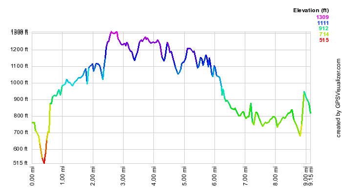
(The image at the left shows the profile of the hike. Remember that all vertical profiles are relative!)
Sterling Forest: AT from Fitzgerald Falls to Little Dam Lake
| Quick Look | ||||
|---|---|---|---|---|
| Difficulty | Round trip | Total climb | Internet Maps | |
|
9.6 mi. | 2280 ft. | AllTrails | |
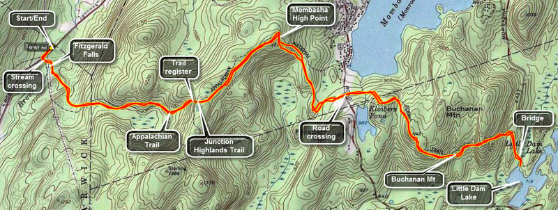
The parking area for the start of this hike is on Orange County Route 5 which may be marked as Dutch Hollow Road, Mountain Lakes Road or Lakes Road. Take Route 17A west from the New York State Thruway or south and east from New York State Route 17 (Quickway). Drive toward Greenwood Lake. From the east drive between the two parts of Greenwood Lake on Route 17A. At the junction with Route 210 bear right before going up the hills. This is Lakes Road. From the Quickway turn right at the bottom of the hill just before entering Greenwood lake. If you reach the Route 210 junction you have gone too far. About 4 miles north on Lakes Road an power line crosses the road. Park just south of this in the pullout by the side of the road. The trail begins here. There is only room here for a few cars. If this area is full, you may be able to park just north of the power lines. Watch for NO PARKING signs. The trail leaves from the eastern side of the road and crosses under the power lines.
Cross a small footbridge and follow the white blazes of the AT as you will all day. The trail crosses Trout Brook which may be a problem when the water is high. No areas are very deep but the crossing is WIDE. In less than .25 miles you will be at Fitzgerald Falls. The falls is formed as Trout Brook cascades down from the ridge above. The trail climbs the rocky ledge next to the brook on the right hand side. In the next half mile you will cross Trout Brook or its small tributaries 4 or 5 times. The trail will gently rise for 1.3 miles until it meets the Highlands Trail marked in blue with the diamond trail markers. The Highlands Trail heads south. At this point there is an AT trail register box. Sign in and read some of the comments made by others. Turn right onto the Highlands Trail and walk a hundred feet for a nice lookout. Return to the trail register and continue east on the AT.
For about .75 miles walk the ridge toward the Mombasha High Point. The trail climbs slightly for the entire length and a little more steeply as you come to the high point. As you approach this point the trail abruptly turns right and follows the edge of a rocky ledge. The trail is well marked but don't miss this sharp turn. At the high point you will have views of the surrounding area. Walk a little further and Mombasha Lake can be seen to the east and north. The view is blocked by trees but when the leaves are not present the lake can be clearly seen. Descend the AT from the high point. The descent is steep at first and then moderates. Some areas are not very well marked so watch ahead for the white blazes. The trail heads south for .5 miles and then turns east again for .25 miles before reaching Route 91. Near the end of the trail it crosses a brook and ascends toward the road. This area can be marshy when it is wet. There is a boardwalk that starts shortly after the stream and continues almost to the road. A small pond appears on the left as you approach the road.
Cross Route 91 and continue on the At over a rocky path that may once have been a stone wall. The trail switches to a smoother and flatter woods road before crossing another stream and ascending slightly. Mombasha Lake is visible on the left and Kloibers Pond is hidden on the right. From here the trail starts to ascend for .85 miles to the shoulder of Buchanan Mountain. The trail turns south for a while and then east as it approaches the mountain. The actual ascent up the mountain becomes steeper passing over and through a rocky area as it reaches the highest point on this part of the trail. From here the trail again starts a descent until it meets a large wall or ridge of rock. You may think that the trail turns to avoid this but, in fact, this is the last climb. It may be the most demanding on this part of the trail. It is rocky and steep and large trees may lay across parts causing you to find creative ways over or around them. One place requires squeezing under and around a large tree across the path. Further up some pretty high steps make the use of hands almost mandatory. This is all made more interesting when the trail is wet or icy!
At the top of the climb the trail levels off and then almost immediately starts to descend for .2 miles to East Mombasha Road. At the road cross over and continue to follow the AT down to the lake. There is room to park along the side of this road. The trail heads almost due south for about .3 miles where there is a footbridge that crosses the area between the two parts of the lake. The AT continues on passed the lake. Follow it for a few hundred feet to get a better view of the lake. At this point you may continue on the AT as far as you want but you have already walked 5 miles and there are 5 miles to go back to the car. The trip back is much the same as the trip out. You will be more tired and the descents become ascents and vice versa.
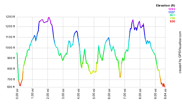
(The image at the left shows the profile of the hike. Remember that all vertical profiles are relative!)
Sterling Forest: AT from Mt. Peter to Fitzgerald Falls (and Beyond)
| Quick Look | ||||
|---|---|---|---|---|
| Difficulty | Round trip | Total climb | Internet Maps | |
|
10.1 mi. | 2237 ft. | AllTrails | |
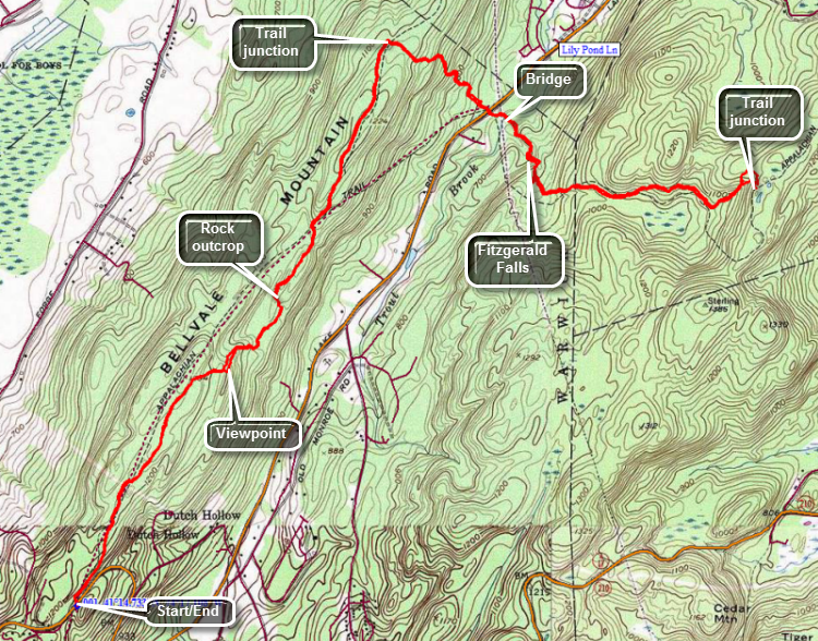
The parking area for the start of this hike is on Route 17A. Take Route 17A west from the New York State Thruway or south and east from New York State Route 17 (Quickway). Drive toward Greenwood Lake. At the top of the hill just passed Mt. Peter, pull into the roadside parking area where the AT crosses the road. The trail is just across the road from the parking area.
Cross the road and turn right as the AT (white blazes) turns in that direction. The blue trail in the opposite direction goes to Mt. Peter. The trail is generally open and easy to follow. There may be several ponds along the way depending on the season. Blowdowns can be a nuisance as they are not always promptly cleared. At 1.3 miles the AT goes up and over a rock outcrop than can be very slippery when wet or icy. The view from top is nice. Avoid this route by using the Highlands Trail to bypass the outcrop. The Highlands Trail turns left off the AT just before the rocks and rejoins the AT not too far to the northeast. The trail heads northeast along the ridge and loses and gains some elevation as it goes. At 1.7 miles another rock outcrop is easily bypassed by the Highlands trail to right. At about 2.3 miles there is a spur trail to the left which goes to the Wildcat Shelter. At 2.9 miles the blue Highlands Trail continues straight ahead. Turn right on the AT as it descends from the ridge to Lakes Road. Cross Lakes Road and pick up the AT directly across the road. You will cross a wooden bridge over Trout Creek. Your next stop is Fitzgerald falls at 3.9 miles. This would be a good place to turn around but you may continue as far as you like since the AT is headed to Maine! Continue on the AT by climbing the steps next to the right of the falls. At the top of the falls walk along the creek until you see the At blazes as they head up to the right. Continue to follow the AT blazes which can be hard to spot at times. You will be on Avery rocky part of the trail which ascends the ridge to a trail junction. At the junction the Highlands Trail heads south while the AT continues northeast and east toward Little Dam Lake. You can continue but turning around here will make the hike very close to 10 miles.
(The image at the left shows the profile of the hike. Remember that all vertical profiles are relative!)
Stewart State Forest (Swamp Figure 8)
| Quick Look | ||||
|---|---|---|---|---|
| Difficulty | Round trip | Total climb | Internet Maps | |
|
6.7 mi. | 700 ft. | AllTrails | |
Find Ridge Road from Route 17K. One way to do this is to take exit 116 east off State Route 17. Turn left on Route 17K and drive 15 miles to Ridge Road which will be on the right. Drive south on Ridge Road for .9 miles and turn left onto Maple Ave. Make an immediate right into the parking lot. This area has several multipurpose trails, many woods roads and a maze of bike trails. This hike is a figure 8 which includes the Great Swamp boardwalk and Buchanan Hill. The trails are not well marked but are easy to follow. The trails roll over low hills with grades of less than 10%.
Start the hike by walking out the blue blazed Scofiled Trail at the back left corner of the parking area. The trail heads south and slightly uphill. The trail is pretty well maintained through a sea of prickers and what look, at times, like Japanese knotweed. There are some small hills to help you get warmed up. After a mile or so, there may be somewet and muddy areas on the trail. At 1.4 miles there is a small pond on the right of the trail. The pond is not marked on maps but is formed by an obvious man-made dam. At 1.6 miles a yellow trail appears on the left. This trail leads to the swamp boardwalk. Turn left and start walking downhill. After .25 miles you will at the beginning of the boardwalk. The boardwalk is very impressive and the construction very sturdy. It includes steel pipes to anchor it in the swamp, stainless steel cables between pipes, and a composite decking. You will enjoy walking along the boardwalk and stopping to take in the view and look for critters. When you reach the end of the boardwalk continue walking on the trail to another section of boardwalk. At the end of this section continue on a dirt road to Maple Avenue. Turne right and almost immediately turn left on the blue blazed Buchanan Hill Trail. Walk downhill to another small pond. Continue your walk passing the end of the pond to a fork in the trail. There is a single blue blaze on a tree in the middle of the fork which gives no indication of which way to go! Choose right and begin to climb up a small hill and then descend the other side. The descent can be wet and muddy. Within a short distance, the trail begins the long but gentle climb up to the top of Buchanan Hill. The trail here may not as well maintained with some briars across the path. From 2.9 miles to 3.4 miles you will climb 150 feet along a gentle 6% grade. Before reaching the summit plateau, you may want to stop to get some pictures of the mountains to the east on the other side of the Hudson. The trail continues as a wide swathe cut through the tall grass and brush arcoss the top of the hill. There are some marker posts as there are other wide swathes cut at times in different directions. The trail eventually enters the woods again but remains wide and easy to follow. After hiking another.7 miles, you will be at Maple Avenue which is 4.1 miles into the hike. Turn right and start the 2.5 mile road walk back to the car. the road is closed to most traffic year-round and is slightly uphill. With about .4 miles to go the road changes to pavement which leads through a gate back to the parking area.
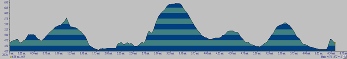
(The image at the left shows the profile of the hike. Remember that all vertical profiles are relative!)
Storm King: All Points Loop from 9W
| Quick Look | ||||
|---|---|---|---|---|
| Difficulty | Round trip | Total climb | Internet Maps | |
| 8.6 mi. | 3201 ft. | AllTrails | ||
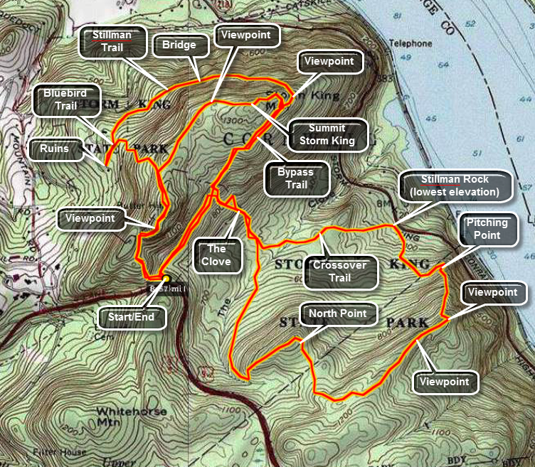 Get on Route 9W on the west side of the Hudson River heading north from West Point toward Newburgh. Between West Point and Newburgh are several parking areas. The "second" parking area on the east side of the highway has a large parking area and is on a rather sharp left hand turn. Heading south you will have to go beyond the area and turn around further down the road since this is a "no turns" part of Route 9W. This approach is easier than parking on Storm King Highway since the ascent is less but not it is as steep or steeper than the trail up from Storm King Highway! Get on the orange trail at the north end of the parking lot and immediately begin to climb. You will pass through an area that has stone pillars that were the "gateway" for some large estate. After this the trail really begins to get steep with only a few flatter sections until near the top. There are areas of exposed rock face and others that require some rock scrambling using feet and hands. As the trail ascends there are some viewpoints along the way but none compare to the ones near and at the top. Keep climbing! After only a little more than half a mile on the trail, it ends at the junction with the yellow blazed Stillman Trail. Turn right here and continue to climb. In a short distance a series of rock ledges open up with great views of Route 9W, the parking area and south on the Hudson. North Point is also visible below and this is an area you may soon visit. After taking in the views and taking some pictures continue on the Stillman Trail bypassing the left turn onto the Bluebird trail and, alter, the right onto the Howell Trail. After the Howell Trail, the Stillman Trail bears left. With half a mile the views from Storm King open up so that you can see north up the Hudson and to the west and east. Each view is better than the next until you are right on top of Storm King with a COMPLETELY open view. This happens just before the trail begins to descend. From this vantage point the Newburgh-Beacon Bridge is visible to the north. To the east is Breakneck Ridge and North and South Beacon Mountains. Pollepel Island is visible with Bannerman Castle. Boats can be seen in marinas lining the river and plying the waters. The views depend on the amount of haze and fog present but on a clear day you can see well beyond the bridge.
The options at this point are many. The shortest is probably back to the car the way you came but this misses some other spectacular views. Perhaps the longest route is the one described in detail here which includes trekking the Orange, Stillman, Bypass, Howell, Stillman Springs, Crossover, and Bluebird Trails! Some of these are used more than once!
Continue on the Stillman Trail as it travels east and slightly south. At the junction with the white marked Bypass Trail turn onto the white trail. The Stillman Trail hooks sharply left and heads back north and west. Continue west on the bypass trail for less than half a mile where it meets the blue blazed Howell Trail. Turn left onto the Howell Trail which you will be on for several miles. The trail descends into The Clove through a series of switchbacks and then climbs out of The Clove to higher ground. The trail widens into a woods road as it winds its way toward North Point passing the junction with the Bobcat Trail. North Point has been burned over at least once and shows it by the being relatively open with many dead trees. There is a large rock near the top which marks the best viewpoint. From here there are wonderful views north toward the bridge and beyond. From North Point you can also look down on Storm King Highway, Bannerman Castle and across the river to Breakneck Ridge. From North Point the Howell Trail continues on around this elevated area. The views change so that you can see south toward West Point with good views down onto the river. The trail near the end descends rather sharply to Pitching Point which looks directly down to the river. The slop then moderates as you descend through open forest to the lowest point on the hike, Storm King Highway.
At the Stillman Springs Rock, pick up the white blazed Stillman Springs Trail which heads north and west. You may continue on this trail until it meets the Howell Trail again or you may look for the Crossover Trail. The markings for the Crossover Trail WERE red but have been painted over in gray signifying that the trail is no longer maintained. I decided to try to follow it just for something different to do. After a short walk up from Storm King Highway, the marks of the Crossover Trail appear on the right. The trail is a little hard to follow and you may find yourself staring intently through the forest at times. A short distance along the trail is an open, grassy clearing on the right. This appears to be a pond in wetter weather. The Crossover Trail is short. When you get to the Howell Trail turn right. The Howell Trail will again take you through The Clove and back up to the Bypass Trail. Turn right on the Bypass Trail and continue to the Stillman Trail.
At the Stillman Trail you may want to go BACK to the top of Storm King by turning left. Sometimes the views later in the day are clearer as the haze burns off. Whether you take this side trip or not get back on the Stillman Trail as it makes a sharp turn around Storm King and heads north and west. The trail at this point passes through some evergreen trees giving the walk a different feel. There are some viewpoints along the way and many switchbacks as the trail skirts and then descends the north slope of the mountain. Along the way is a bridge attached to a rock face to get across a small ravine. Watch for the Bluebird Trail on the left marked with red and blue paint. You can turn left on the Bluebird Trail or right on an old woods road. Down the road are some ruins of moderate interest. The Bluebird Trail ascends back to near the top of Storm King and the ascent is steep at times.
When the Bluebird Trail ends, turn right on the Stillman Trail and retrace your path from earlier in the day. Be sure to stop at the various lookouts as the light will be different. These views can look MUCH different in the afternoon than in the morning! Descend the yellow Stillman Trail and watch for the orange trail back to the parking area on Route 9W. The orange trail turns to the left. Be careful as you descends since some areas are VERY steep and accidents more often occur on descents! The entire route is about 8 miles but your time can vary greatly depending on the number of stops and their length.
(The image at the left shows the profile of the hike. Remember that all vertical profiles are relative!)
Storm King: Bobcat Trail Loop from 9W
| Quick Look | ||||
|---|---|---|---|---|
| Difficulty | Round trip | Total climb | Internet Maps | |
| 8.4 mi. | 3138 ft. | AllTrails | ||
_map.png) Get on Route 9W on the west side of the Hudson River heading north from West Point toward Newburgh. Between West Point and Newburgh are several parking areas. Watch for a small parking area on the east side of the highway with a small kiosk. This is the trailhead for the Bobcat Trail. The Bobcat Trail descends from the Route 9W parking area to a junction with the blue blazed Howell Trail that ascends to North Point. The Bobcat Trail is a little over a quarter mile long to the junction with the Howell Trail. Turn right at the junction to climb up and over North Point. Take some pictures of Storm King and the upper Route 9W parking area. You can see how the Storm King Highway really DOES hang on the edge of the mountain! The trail makes a right turn after North Point and heads southeast until it again rises to a point higher than North Point. After this the trail turns northeast and descends a ridge line towards the river. From this ridge there are views down to the river and across the river to the Hudson Highlands especially to Mount Taurus and Little Stony Point. Walk along this ridge for .65 miles until you are on a lookout on a cliff right above the river. You will be about 1.7 miles into the hike and ready to start the decent down to the Storm King Highway. From the lookout down to Pitching Point the trail drops over 500 feet in .4 miles with an average grade of over 20%. At the bottom of the steep descent the trail turns sharply to the left. Turn to the right and walk a short distance out to Pitching Point. The views here are actually not as good as from the top but it is interesting to look at the highway less than 300 feet away and almost straight down! Back on the main trail and walk about .4 miles downhill to the Storm King Highway. The trail ends/begins at a parking area near Stillman Springs. The Storm King land was donated to the Palisades Interstate Park Commission by the Stillman family in 1922 and there is an inscription near a spring that commerce this act. Walk north along the highway and then immediately pick up the white blazed Stillman Spring Trail at about 2.5 miles into the hike and 850 feet lower than your starting point.
Get on Route 9W on the west side of the Hudson River heading north from West Point toward Newburgh. Between West Point and Newburgh are several parking areas. Watch for a small parking area on the east side of the highway with a small kiosk. This is the trailhead for the Bobcat Trail. The Bobcat Trail descends from the Route 9W parking area to a junction with the blue blazed Howell Trail that ascends to North Point. The Bobcat Trail is a little over a quarter mile long to the junction with the Howell Trail. Turn right at the junction to climb up and over North Point. Take some pictures of Storm King and the upper Route 9W parking area. You can see how the Storm King Highway really DOES hang on the edge of the mountain! The trail makes a right turn after North Point and heads southeast until it again rises to a point higher than North Point. After this the trail turns northeast and descends a ridge line towards the river. From this ridge there are views down to the river and across the river to the Hudson Highlands especially to Mount Taurus and Little Stony Point. Walk along this ridge for .65 miles until you are on a lookout on a cliff right above the river. You will be about 1.7 miles into the hike and ready to start the decent down to the Storm King Highway. From the lookout down to Pitching Point the trail drops over 500 feet in .4 miles with an average grade of over 20%. At the bottom of the steep descent the trail turns sharply to the left. Turn to the right and walk a short distance out to Pitching Point. The views here are actually not as good as from the top but it is interesting to look at the highway less than 300 feet away and almost straight down! Back on the main trail and walk about .4 miles downhill to the Storm King Highway. The trail ends/begins at a parking area near Stillman Springs. The Storm King land was donated to the Palisades Interstate Park Commission by the Stillman family in 1922 and there is an inscription near a spring that commerce this act. Walk north along the highway and then immediately pick up the white blazed Stillman Spring Trail at about 2.5 miles into the hike and 850 feet lower than your starting point.
The Stillman Spring Trail starts at the highway and heads west and southwest back toward the Howell Trail. Along its .7 mile length it gains over 400 feet. You may find the short Crossover Trail on the right but this has been "and can be hard to find. When you reach the Howell Trail, turn right to head toward "The Clove", the low point between North Point and Storm King. The Clove has two different streams running through it. At 3.45 miles you should be at the bottom and ready to start the climb up toward Storm King. The trail rises 550 feet in .5 miles to a junction with the white Bypass Trail. Turn right on the Bypass Trail as it has some nice views to the south which you cannot get from the summit of the mountain. The walk along the Bypass Trail presents some very nice views and there are several opportunities to take alternate routes which visit different viewpoints. There is a nice lookout at the junction of the Bypass Trail and the Stillman Trail. When you reach the lookout, walk up to a large open rock for some nice views. Continue on the Stillman Trail which wraps around the north side of Storm King Mountain. In many places the trail really hangs on the side of the mountain with a steep drops to the north and little room on the other side. This makes the trail "challenging" when it is wet or icy! At one point you will come to a bridge that spans a spot where there would be no trail without it. From the junction of The Bypass and Stillman Trails is only .9 miles. Turn left on the Bluebird Trail which regains in .5 miles the 480 feet lost on the way down the Stillman Trail. There are numerous switchbacks on the trail but it is still a good climb. At the next trail junction turn left of the Stillman Trail to head over the summit of Storm King. This .7 mile section is relatively flat but does gain almost 100 feet to the summit before dropping back down to the junction with the Bypass Trail. The last viewpoint is the only one really worth the stop since it is much more open than the others.
At 6.5 miles you should be back at the junction with the Bypass Trail where you should turn right to start your trip back. Drop down the Bypass Trail to the junction with the Howell Trail and then continue down through "The Clove". Once you are at the junction with the Stillman Springs Trail continue straight ahead on the Howell Trail back to the junction with the Bobcat Trail just before the Howell Trail climbs North Point. It is only .8 miles from the Stillman Springs junction to the parking area.
_gra.png)
(The image at the left shows the profile of the hike. Remember that all vertical profiles are relative!)
Storm King: Bypass Loop from 9W
| Quick Look | ||||
|---|---|---|---|---|
| Difficulty | Round trip | Total climb | Internet Maps | |
| 6.4 mi. | 2555 ft. | AllTrails | ||
 Get on Route 9W on the west side of the Hudson River heading north from West Point toward Newburgh. Between West Point and Newburgh are several parking areas. The "second" parking area on the east side of the highway has a large parking area and is on a rather sharp left hand turn. Heading south you will have to go beyond the area and turn around further down the road since this is a "no turns" part of Route 9W. This approach is easier than parking on Storm King Highway since the ascent is less but not it is as steep or steeper than the trail up from Storm King Highway!
Take the orange Butter Hill Trail out of the parking area and watch for the stone columns at the top of the first short climb. At .3 miles right on the yellow Stillman Trail, one of the main trails in the park. Continue climbing up to the top of the Stillman Trail at about .4 miles and then descend to the junction with the blue and red Bluebird Trail at .6 miles. There aren't many views along this trail and the walk is difficult since it alternates between rocky sections and wet areas. There is a woods road along the way that turns left to some ruins. These ruins aren't very old and aren't too impressive but they are only a short distance and right on the road. At 1 mile turn right at the junction with the yellow Stillman Trail. This part of the trail enters some nice evergreen forest and begins to climb on the edge of the mountain. The trail is narrow and in one place a bridge is needed to cross a usually dry "gorge". As the trail climbs it heads toward the river and skirts the summit of Storm King Mountain. There are some nice views of the river below. The Stillman Trail continues to the summit of Storm King where there are some nice views to the north. Retrace your path back down the Stillman Trail to the junction with the white Bypass Trail. The Bypass Trail descends until at about 2.4 miles it meets the blue Howell Trail which heads south. The Howell Trail continues to descend into a low area called The Clove between the higher ground of Storm King on one side and North Point on the other. At 2.7 miles turn left on the red Crossover Trail. This trail is now unofficial and the blazes have been painted over but you can take it anyway. At 3.0 miles you will intersect the white Stillman Spring Trail where you should turn left and continue to descend. The Stillman Spring Trail eventually ends at Stillman Spring on the Storm King Highway. This is the lowest point on the hike and represents an almost 1100 foot drop from Storm King. At the spring pick up the beginning of the blue Howell Trail which starts your long climb to North Point. At 3.6 miles walk straight ahead as the main trail turns right. This will bring you to a nice lookout called Pitching Point. The Howell Trail continues to climb as it heads south and then southwest. The vegetation here is almost all hardwood with a lot of small trees and brush. There are also many open fields. The area around North Point has burned several times accounting for the ecology that is so evident. You will hit the highest point on this part of the southern loop and then descend slightly before climbing to North Point. The area here is very open and there are intriguing views of the river, Polopel Island and Storm King Highway as it winds its way around the mountain. Walk across the open space at the top of North Point. To your right you may be able to spot you car in the parking area further up 9W. Walk down to a wide woods road where the white Bobcat Trail joins from the lower parking area on 9W. Continued on the Howell Trail as it descends into The Clove passing the Stillman Trail at 5.4 miles and the Crossover Trail at 5.6 miles. From this low point in the Clove, the gain in elevation is almost 500 feet over the next .35 miles on the Howell Trail. At the top if the climb turn left on a "proposed" trail which seems to be an extension of the Bypass Trail. There are only a few blazes but the wide road is easy to follow. On your right side will be some really impressive cliffs that make up the foot of Storm King. Continue to hike up a steep little grade to the parking area.
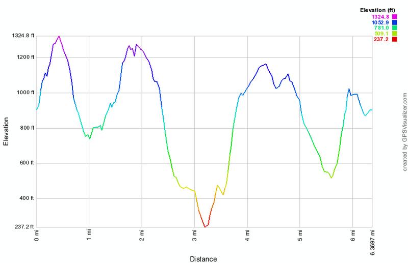
(The image at the left shows the profile of the hike. Remember that all vertical profiles are relative!)
Storm King: Loop from Storm King Highway
| Quick Look | ||||
|---|---|---|---|---|
| Difficulty | Round trip | Total climb | Internet Maps | |
| 5.8 mi. | 2127 ft. | AllTrails | ||
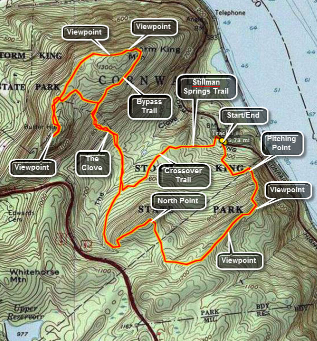 Get on Storm King Highway on the west side of the Hudson River. Between West Point and Cornwall-on-Hudson are several parking areas. The "middle" parking area on the east side of the highway has a spring and a rock with an inscription commemorating the gift of land by the Stillman family. Park here and your adventure is about to begin! The trail to the left of the spring is the blue blazed Howell Trail. This approach is more difficult than parking on 9W since the ascent is greater but not too difficult. The trail ascends to a woods road and then continues upward on an old woods road. After less than a mile, the trail turns right and ascends more steeply along a route involving a couple of switchbacks and some stone steps. Eventually the trail opens up onto some rocks giving you the first of some absolutely spectacular views. This is Pitching Point with views across the river to Breakneck Ridge and Bannerman Castle. Up the river is the Newburgh-Beacon Bridge while downriver you can see West Point. As good as these views are the best is yet to come!
Continue on the Howell Trail and enjoy the various views as they come your way. Look over to Storm King Mountain and down to the highway which appears to hang on its very edge. A little further west and closer is an almost bald, burned over area. This is North Point and the Howell Trail will take you there soon enough. Watch on your left for more views down the Hudson. The quality of the views depends largely on the amount of humidity and haze in the air. Soon the Howell Trail which was headed west takes a sharp turn right and heads north. You will notice more open areas and many dead trees as you ascend to North Point. From North Point you can look northeast toward Storm King Mountain, directly north to Butter Hill or a little west of north and see Route 9W. On 9W is another parking area which allows easier access to trails that ascend Storm King.
The Howell Trail now descends the other side of North Point and joins a woods road for some distance. be sure to STAY ON the blue blazed trail as other trails and unmarked woods roads intersect the Howell trail at several points. One of the trails is the Stillman Springs Trail which you will use on the way back. You will descend into The Clove rather gently but then ascend out of The Clove rather more steeply. The Howell Trail makes an abrupt right near the top of the ascent, joins a woods road and moderates some. After a very short walk, the Howell Trail heads north again. At this point the Bypass Trail, your route on the way back, goes straight ahead. Continue on the blue trail until it meets the yellow blazed Stillman Trail. This is the main trail that accesses Storm King Mountain. Turning right at the junction takes you directly around Storm King. Turn left and head toward Butter Hill for some nice views of the Hudson and Route 9W. You will get to an open rock faces where these views are very obvious. At this point turn around and retrace your steps back to the junction with the Howell Trail. Turn left to continue on the Stillman Trail around Storm King Mountain.
As you hike along the Stillman Trail there are numerous lookouts and viewpoints each more amazing than the next. Most of these views are to the north and east. On a clear day you can see well passed the Newburgh-Beacon Bridge to the north. The fire tower on South Beacon Mountain is clearly visible as is the summit of North Beacon Mountain. The climbers working their way up Breakneck Ridge are an interesting site! As you head south on the trail you will arrive at a point where the Stillman Trail abruptly turns east and then hooks back north and west. The views here are to the east and south toward West Point. As the yellow blazed Stillman Trail makes its turn, the white marks of the Bypass Trail appear on the right. Turn here to head back toward the Howell Trail which will be your way back to your car. The Bypass Trail passes between two low rock ridges as it makes its way back to the Howell Trail. There are views primarily to the south and east but you may have to walk up onto the rock ridge on your left to see them.
After a short walk, turn left on the blue blazed Howell Trail and descend into The Clove. This is the ascent you made earlier so things SHOULD look familiar. The blazes on the red marked Crossover Trail have been painted over to indicate it is no longer available. Continue on the Howell Trail until the white blazes of the Stillman Springs Trail appear on the left. This is mostly an old woods road and the pitch is not too steep. In less than a mile you will be back on Storm King Highway just north of where you are parked. The total distance is under 6 miles and will and will vary based on how many side trips you take. The time can be relatively quick but most people stop for pictures and to marvel at the views.
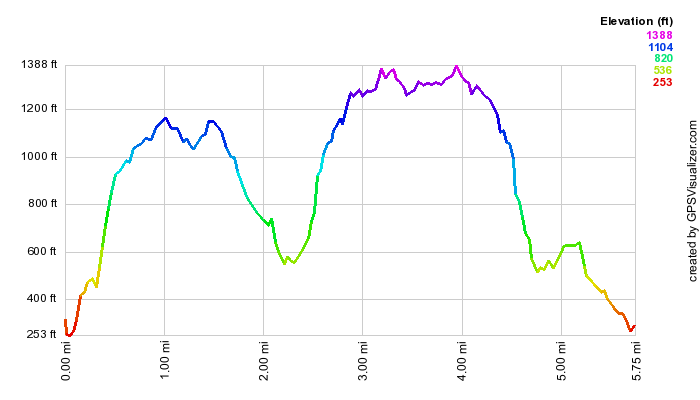
(The image at the left shows the profile of the hike. Remember that all vertical profiles are relative!)
Storm King: Stillman Loop from 9W
| Quick Look | ||||
|---|---|---|---|---|
| Difficulty | Round trip | Total climb | Internet Maps | |
| 6.8 mi. | 3005 ft. | AllTrails | ||
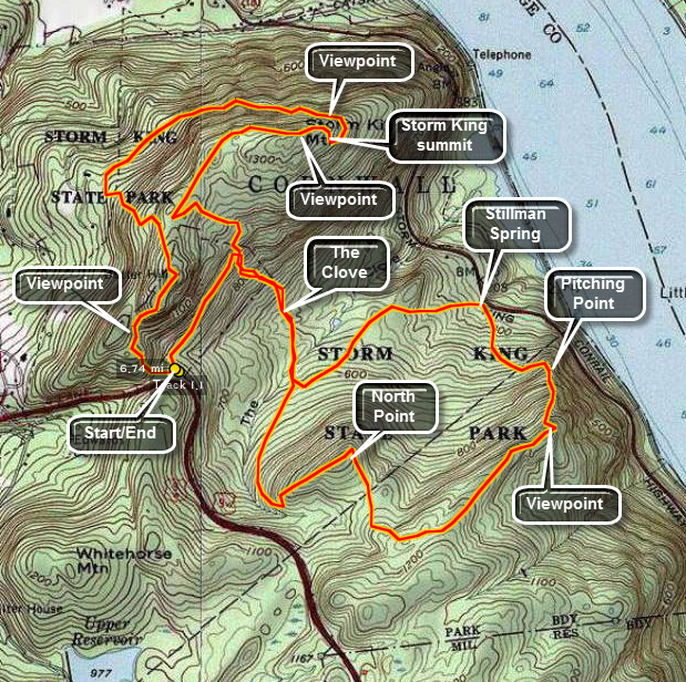 Get on Route 9W on the west side of the Hudson River heading north from West Point toward Newburgh. Between West Point and Newburgh are several parking areas. The "second" parking area on the east side of the highway has a large parking area and is on a rather sharp left hand turn. Heading south you will have to go beyond the area and turn around further down the road since this is a "no turns" part of Route 9W. This approach is easier than parking on Storm King Highway since the ascent is less but not it is as steep or steeper than the trail up from Storm King Highway!
Take the orange Butter Hill Trail out of the parking area. Boterberg or Butter Hill is one of the early Dutch names for Storm King since it looked like a lump of butter. This name is still used for the western summit which actually is 40 feet higher at 1380 feet than Storm king itself! There are some nice views from Butter Hill across the river to Little Stony Point, Mount Taurus and Breakneck Ridge. To get to the top of Butter Hill turn right on the yellow Stillman Trail which leads to the summit. Continue over the top on the Stillman Trail and begin to descend into the area between Butter Hill and Storm King. When you meet the red and blue marked Bluebird Trail turn left and begin an interesting descent. The Bluebird Trail descends steeply in places and there aren't many viewpoints. The Bluebird Trail ends with a junction with the Stillman Trail as it come up from Mountain Road in Cornwall. Turn right to walk along the edge of Storm King as the trail slowly ascends the mountain through a series of shallow grades and switchbacks. Cross the Stillman Bridge, a wooden structure which bridges a gap in the trail where there is no ground to speak of but a steep drop off near a vertical rock wall. Right after the bridge is an open wooden staircase. Just after the bridge a series of switchbacks announces the climb up Storm King is almost done. On the way up the Stillman Trail several nice views can be had from a few lookouts. Near the top of the trail there are even more viewpoints as the trail passes by several open rock shelves. The only view that is blocked is to the north! Continue on the Stillman Trail up over the top of Storm King to take in some of the best views especially to the north. Continue on the Stillman Trail down the other side of the mountain. At the junction with the blue Howell Trail turn left and descend through The Clove. There is NOTHING to see as you descend into The Clove. The trail is steep in places . Near the bottom you will cross the small stream that lies at the bottom of The Clove. Just before this crossing you may see the markings of the former Crossover Trail which are now painted over indicating the trail is officially closed. Just after the stream you will see the white marks of the Stillman Spring Trail on the left. Continue on the Howell Trail as it starts to ascend out of the clove rather steeply but then moderates on an old woods road. After this the road ascends more steeply and the trail turns off to the left. At this point the Bobcat Trail comes in from the lower parking area on 9W. Follow the Howell Trail to the left and begin the steep but short hike up to North Point. There are GREAT views here down to and across the river! Continue down the Howell Trail off North Point and walked for a while before the trail starts to head due east towed the river and several nice viewpoints start to appear. These viewpoints are mostly to the south and east and views of West Point are possible. The trail begins to descend again very steeply as it heads down toward the river and the Storm King Highway. The last good lookout is Pitching Point which is less than 500 horizontal feet from the highway. The trail then winds its way away from the road and switches back several times before ending at Stillman Spring. Walked north a hundred feet on the highway before turning left back into the woods on the white Stillman Spring Trail. This trail ascends right from the beginning but never steeply as it heads back to the Howell Trail just above the deepest part of The Clove. At the Howell Trail turn right and hike up out of the Clove toward Storm King. As the trail nears the area where it levels off near the top of the mountain, another trail turns left. This trail is marked in white but is shown as "proposed" on the maps. The maps also show the trail running directly west but it really runs southwest. This trail descend some before ascending and then descending again. The last few hundred feet is a steep climb back to the parking area on 9W.
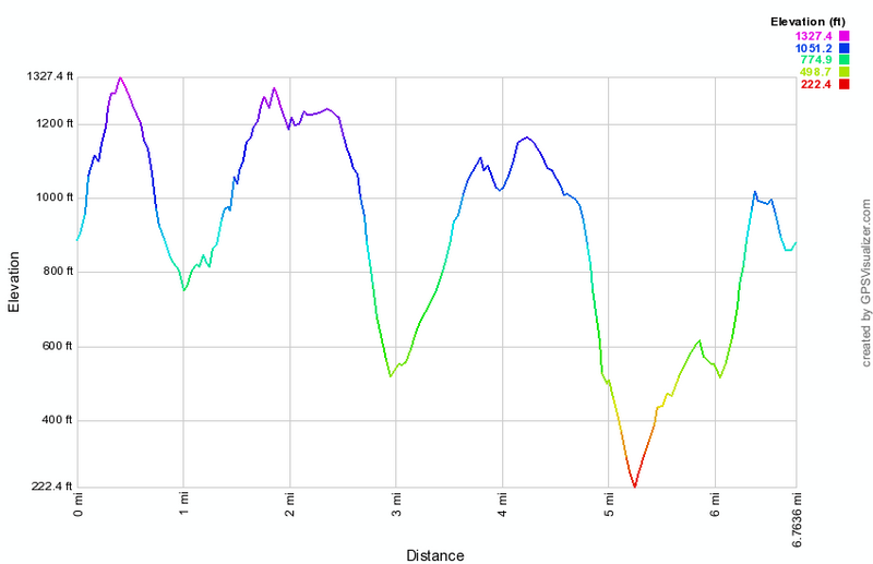
(The image at the left shows the profile of the hike. Remember that all vertical profiles are relative!)
Tors: Little Tor and High Tor
| Quick Look | ||||
|---|---|---|---|---|
| Difficulty | Round trip | Total climb | Internet Maps | |
| 8.5 mi. | 1492 ft. | AllTrails | ||
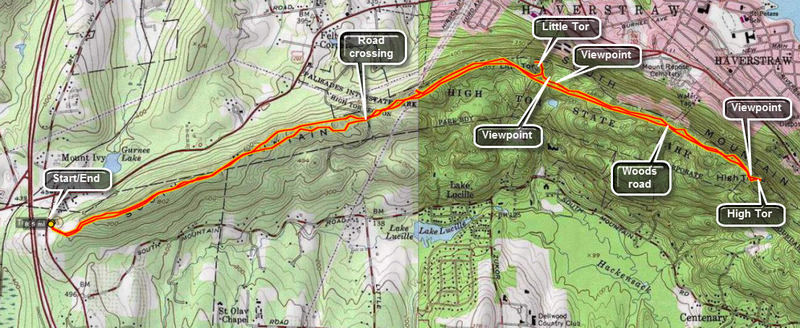
Take the Palisades Parkway to Exit 13 and turn onto Route 202 East. At the first traffic light turn south on Route 45. Just up the hill is a parking lot on the right or east side of the road. Park here. Note the signs warning about ticks and Lyme Disease and be sure to take appropriate precautions. The hike is a relatively straight forward out and back route that follows the Long Path for its entire length. The trail meanders up and down some and back and forth only slightly as it follows the ridge line the entire way. You may cut off the first part of the hike by parking on Route 33 where the Long Path crosses the road. There is room for several cars. Little Tor and High Tor are both east of this parking area and the "trail" is over wide woods roads for the mots part.
From the Route 45 parking area walk east on the Long Path following the aqua blazes. Walk off the trail to the left or right occasionally to enjoy the view. North or left is heavily populated while south or right seems more wild. After 1.75 miles, you will descend to Route 33. Be careful when crossing since both north and south have blind curves and the drivers are always going too fast. At this point the trail becomes a wide road which is often covered with stone chips. The walking is easy and your pace can increase. After only .3 miles a power line crosses the trail and a path leads up and to the left. This is a good lookout to the north but nothing like what is to come. In a little more than 1 mile from Route 33 a wide path turns to the left away from the main trail and leads to Little Tor.
As you walk up the path stop on the edge of the cliff and look at the views laid out below. Now turn back to the path and follow it to the top of Little Tor for the really remarkable 360 degree panorama. The Hudson River is to the east and the jutting rock formation is part of High Tor. When you have taken in all you can, retrace your route to the main trail and walk another 1.25 miles to High Tor. The trail breaks up a little and may be wet in places but this is not really a problem. As you approach High Tor you may wonder how you can climb such a massive piece of rock. Do not fear! The Long Path bends to the right hear and then turns sharply left up the "back" of the tor. This part of the trail is steep in places with some rock scrambling but it is also short and well worth the effort.
After the brief climb, the trail levels some and then ascends to the top of the tor. To the left is a large, flat, open rock outcropping which offers unhindered views of the populated area below. There are also views of the Hudson River and the more forested areas west and south. Immediately to the east rises another prominent rock outcropping which is the top of the tor. Head for this area and ascend over the bare rock face which can be slippery when wet. Near the top you will see four anchors which are all that remain of a tower which housed and airplane beacon. You will now have an unhindered 360 degree view of all that is near and far. On a clear day the view is one of the nicest in the lower Hudson Valley. After getting a drink and a snack, take some pictures and then retrace your route back to the car.
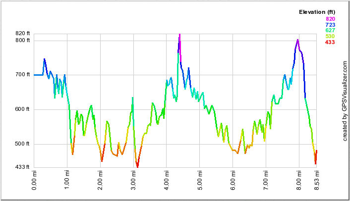 (The image at the left shows the profile of the hike. Remember that all vertical profiles are
relative!)
(The image at the left shows the profile of the hike. Remember that all vertical profiles are
relative!)